7th May 2022 @ 9.00 pm.
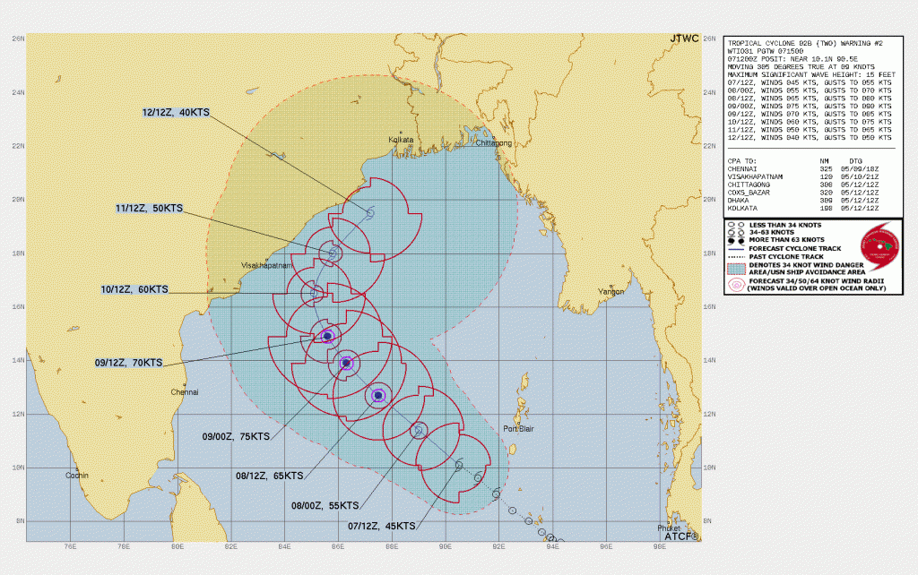
JTWC Tropical Cyclone Warning No. 2 ( Deep Depression as per IMD)
6th May 2022
દક્ષિણ આંદામાન ના દરિયા અને લાગુ દક્ષિણ પૂર્વ બંગાળ ની ખાડી માં આજે સવારે એક લો પ્રેસર થયું – આ સિસ્ટમ ઉત્તર પશ્ચિમ તરફ ગતિ કરશે અને ઉત્તરોત્તર મજબૂત થશે. તારીખ 8 મેં સુધીમાં વાવાઝોડા માં ફેરવાય જાય તેવી શક્યતા છે.
A Low Pressure Develops Over South Andaman Sea & Adjoining Southeast Bay Of Bengal – Expected To Intensify To Cyclonic Storm by 8th/9th May 2022
A Low Pressure Area lies over South Andaman Sea & adjoining Southeast Bay of Bengal at 0830 hours IST of today, the 6th May, 2022. It is very likely to move northwestwards and intensify into a Depression over southeast Bay of Bengal by 7th May evening and into a Cyclonic Storm over Eastcentral Bay of Bengal by 8th May evening. It is very likely to continue to move northwestwards and reach Westcentral and adjoining northwest Bay of Bengal off North Andhra Pradesh and Odisha coasts on 10th May. System track from 10th onwards will be updated in a day or two.
દક્ષિણ આંદામાન ના દરિયા અને લાગુ દક્ષિણ પૂર્વ બંગાળ ની ખાડી માં આજે સવારે એક લો પ્રેસર થયું છે. આ સિસ્ટમ ઉત્તર પશ્ચિમ તરફ ગતિ કરશે અને ઉત્તરોત્તર મજબૂત થશે. તારીખ 8 મેં સુધીમાં વાવાઝોડા માં ફેરવાય જાય તેવી શક્યતા છે. તારીખ 10 સુધી માં નોર્થ આંધ્ર ઓડિશા ના કિનારા બાજુ પહોંચશે. ત્યાર બાદ ના સિસ્ટમ ટ્રેક બાબત અસ્પષ્ટ છે, જે હવે પછી અપડેટ થશે.
IMD SPECIAL MESSAGE (BOB/03/2022)
TIME OF ISSUE:0100 HOURS IST DATED: 06.05.2022
Current Weather Conditions on 6th May 2022
Gujarat Observations:
Currently no Heat Wave prevails over Saurashtra, Gujarat & Kutch. The Maximum Temperatures are currently near normal or above normal by 1 C.
Maximum Temperature on 5th May 2022 was as under:
Ahmedabad 41.6 C
Rajkot 41.3 C
Amreli 40.6 C
Bhuj 40.4 C
Forecast: Saurashtra, Gujarat & Kutch: 6th May To 13th May 2022
Winds will blow mainly from Westerly till 9th May and then from Southwesterly direction till 13th May. Wind speed of 10 to 25 kms/hour during 6th to 8th May. The wind speed will increase from 9th May onwards to 15-30 kms/hour with gusts of 35 kms/hour.
Maximum Temperature expected to increase by 1 C to 3 C between 8th May to 10th May and Maximum Temperature range of 42C to 44 C and subsequently 41 C- to 43 C range till end of forecast period.
An UAC could develop near/over Gujarat State during 10th/13th May. Scattered Cloudy weather expected during this time with atmospheric instability. Possibility of scattered showers.
પરિસ્થિતિ:
સૌરાષ્ટ્ર ગુજરાત અને કચ્છ માં ગરમી નોર્મલ નજીક છે. તાપમાન 40C થી 42 C રેન્જ માં છે.
આગાહી સૌરાષ્ટ્ર, ગુજરાત અને કચ્છ 6 મે થી 13 મે 2022
તારીખ 10 મે સુધી પવન મુખ્યત્વે પશ્ચિમી અને ત્યાર બાદ આગાહી આખર સુધી દક્ષી પશ્ચિમી પવન રહેશે. પવન ની ગતિ 10-25 કિમિ/કલાકે 6 થી 8 મે સુધી અને ત્યાર બાદ 9 મે થી આગાહી અંત સુધી પવન 15-30 કિમિ/કલાકે ની ઝડપ અને ઝાટકા ના પવન 35 કિમિ/કલાકે ના રહેશે. આખા દિવસ માં સૌથી વધુ પવન સાંજે જોવા મળશે.
સૌરાષ્ટ્ર, ગુજરાત અને કચ્છ માં મહત્તમ તાપમાન માં આવતી કાલ થી ક્રમશ વધશે અને તારીખ 8 થી 10 મે દરમિયાન 42 C થી 44 C રેન્જ માં રહેવાની શક્યતા. બાકી ના દિવસો માં 41 C થી 43 C ની શક્યતા છે.
ગુજરાત રાજ્ય ઉપર /આસપાસ એક યુએસી થવાની શક્યતા છે તારીખ 10 થી 13 મેં દરમિયાન. છુટા છવાયા વાદળો થશે અને અસ્થિરતા જોવા મળશે. છાંટા છૂટી ની શક્યતા.
Caution: Please refer/rely on IMD/RSMC Bulletins/Advisories for Storms & Weather related matter.
સાવચેતી: સ્ટોર્મ કે હવામાન અંગે ની માહિતી માટે ભારતીય હવામાન ખાતા/ગવર્મેન્ટ ના બુલેટીન/સુચના પર નિર્ભર રહેવું.
Read Comment Policy – કમેન્ટ માટે માર્ગદર્શન વાંચો
How To Upload Profile Picture For WordPress – વર્ડપ્રેસ માં પ્રોફાઈલ પિક્ચર કેમ રાખવું
Forecast In Akila Daily Dated 6th May 2022
Forecast In Sanj Samachar Daily Dated 6th May 2022