Current Weather Conditions on 13th June 2021
As per IMD:
The Southwest Monsoon has further advanced into some more parts of Madhya Pradesh; entire Chhattisgarh, Odisha, West Bengal, Jharkhand and Bihar; most parts of East Uttar Pradesh; some parts of West Uttar Pradesh; entire Uttarakhand, Himachal Pradesh and Jammu & Kashmir, Ladakh, Gilgit-Baltistan & Muzaffarabad; some parts of north Haryana, Chandigarh and north Punjab today, the 13th June, 2021. Conditions are favorable for further advance of southwest monsoon into most parts of Madhya Pradesh; remaining parts East Uttar Pradesh; Delhi; some parts of West Uttar Pradesh, Haryana and Punjab during next 48 hours.
The Low Pressure Area lies over northwest Bay of Bengal and adjoining coastal areas of West Bengal and north Odisha and the associated cyclonic circulation extends up to mid-tropospheric levels tilting southwestwards with height. It is likely to move west-northwestwards across Odisha, Jharkhand and
North Chhattisgarh during next 2-3 days. A trough runs from central Pakistan to center of low pressure area over Northwest Bay of Bengal in lower tropospheric levels and another trough runs from the cyclonic circulation associated with low pressure area to Eastcentral Arabian Sea in mid tropospheric levels. An off shore trough at mean sea level runs from north Maharashtra coast to Lakshadweep area.
Under the influence of above systems: Scattered to widespread rainfall with isolated thunderstorm & lightning over most parts of Northwest, Central, East, Northeast & south Peninsular India and over parts of West India. Isolated heavy to very heavy rainfall very likely over parts of Northwest India during next 3 days; over parts of East, Central & West India during next 3-4 days; over parts of Northeast India during next 5 days and over parts of south Peninsular India during next 4-5 days. Isolated extremely heavy falls also very likely over Konkan & Goa on 14th & 15th and over Coastal Karnataka and Madhya Maharashtra on 15th June, 2021.
ચોમાસુ નોર્થ ઇન્ડિયા સુધી પહોંચ્યું છે. છતાં નોર્થ વેસ્ટ ઇન્ડિયા, પશ્ચિમ યુપી, એમપી ના અમુક ભાગો બાકી છે. સૌરાષ્ટ્ર કચ્છ તેમજ ગુજરાત રિજિયન ના મોટા ભાગો બાકી છે. નકશામાં ચોમાસુ રેખા બતાવેલ છે.
દક્ષિણ સૌરાષ્ટ્ર કિનારે ચોમાસુ રોકાયેલ છે. સૌરાષ્ટ્ર ગુજરાત અને કચ્છ માટે ચોમાસા ની ગતિ મંદ રહેલ છે.
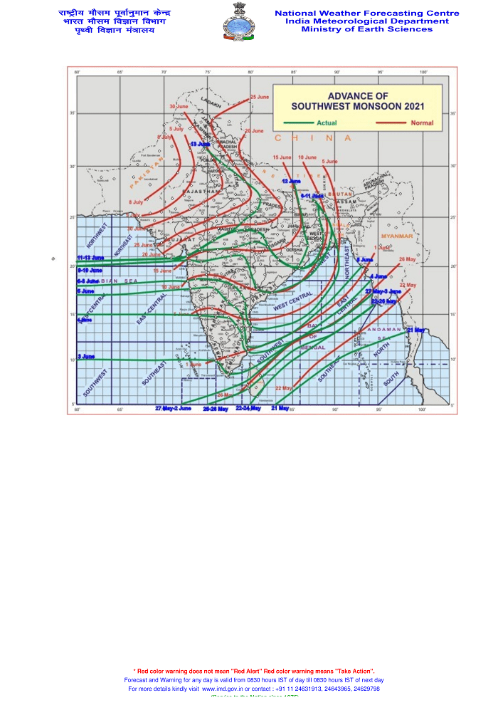
સૌથી ઉપર ની લીલી લીટી ના છેડે જે તારીખ હોઈ તે તારીખે લીટી ની નીચે ના ભાગ માં બધે ચોમાસું પોંચી ગયું છે તેમ સમજવું.
લાલ લીટી જે તે વિસ્તાર માં નોર્મલ ચોમાસું બેસવાની તારીખ દર્શાવે છે
The date shown at the end of green line shows that the Southwest Monsoon has set in over areas below the green line on that date.
The red line shows the normal date of onset of Southwest Monsoon over various regions
Caution: Please refer/rely on IMD/RSMC/Government Bulletins/Advisories for Storms & Weather related matter.
સાવચેતી:સ્ટોર્મ કે હવામાન અંગે ની માહિતી માટે ભારતીય હવામાન ખાતા/ગવર્મેન્ટ ના બુલેટીન/સુચના પર નિર્ભર રહેવું.
Click the links below. Page will open in new window
Read Comment Policy– કમેન્ટ માટે માર્ગદર્શન
ઉપર ની બધી અલગ લિન્ક ક્લિક કરો. નવી વિન્ડો માં પેજ ખૂલશે