Southwest Monsoon Marking Time Near South Coastal Saurashtra & South Gujarat 11th June 2021 Onwards
દક્ષિણ પશ્ચિમ ચોમાસુ દક્ષિણ સૌરાષ્ટ્ર કિનારે અને દક્ષિણ ગુજરાત પર 11 જૂન થી સ્થગિત છે.
Current Weather Conditions on 16th June 2021
Some weather parameters as per IMD:
The Northern Limit of Monsoon (NLM) continues to pass through lat. 20.5°N/ Long. 60°E, Diu, Surat, Nandurbar, Bhopal, Nowgong, Hamirpur, Barabanki, Bareilly, Saharanpur, Ambala and Amritsar.
Large-scale atmospheric conditions are not favorable for further advance of monsoon into Rajasthan, remaining parts of Gujarat, Punjab, Haryana and Delhi. However, there could be slow progress into some more parts of Uttar Pradesh during next five days in association with the existing cyclonic circulation over East Uttar Pradesh in the lower levels.
The Low Pressure Area over east Uttar Pradesh & adjoining Bihar has become less marked. However, the associated cyclonic circulation lies over East Uttar Pradesh & neighborhood and extends up to 3.1 km above mean sea level.
The Western Disturbance is now seen as a trough in mid & upper tropospheric westerlies with its axis at 5.8 km above mean sea level roughly along Long. 70°E to the north of Lat. 22°N.
The trough at mean sea level from Northwest Rajasthan to northwest Bay of Bengal now runs from south
Punjab to south Assam across south Haryana, north Uttar Pradesh, central Bihar and north Gangetic West Bengal and extends up to 0.9 km above mean sea level.
The off shore trough at mean sea level now lies off Karnataka-Kerala coasts.
The trough from east central Arabian sea to South Konkan now runs from central parts of south Arabian Sea to south Konkan between 4.5 km & 5.8 km above mean sea level
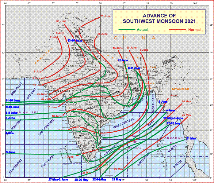
સૌથી ઉપર ની લીલી લીટી ના છેડે જે તારીખ હોઈ તે તારીખે લીટી ની નીચે ના ભાગ માં બધે ચોમાસું પોંચી ગયું છે તેમ સમજવું.
લાલ લીટી જે તે વિસ્તાર માં નોર્મલ ચોમાસું બેસવાની તારીખ દર્શાવે છે
The date shown at the end of green line shows that the Southwest Monsoon has set in over areas below the green line on that date.
The red line shows the normal date of onset of Southwest Monsoon over various regions
Forecast 16th June to 23rd June 2021
For Saurashtra, Gujarat & Kutch: Monsoon progress expected to be weak. Widespread significant rainfall is not expected during the forecast period. Isolated showers and light rain possible at different locations on different days of forecast period, with more quantum and probability over Coastal Saurashtra, South Gujarat and North Gujarat areas. Due to humidity the real fill Temperature will be uncomfortable. Winds mainly from Southwest direction at 15-25 km speed and higher in evening time. Cloudy of and on.
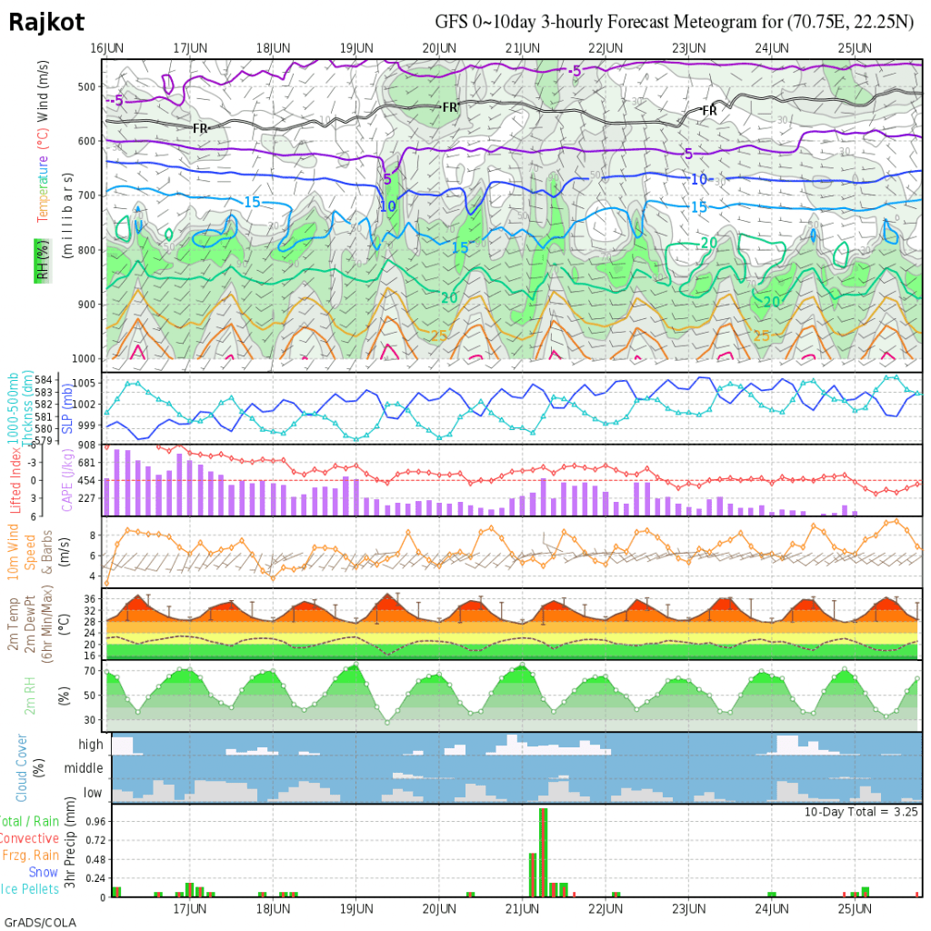
COLA Meteogram For Rajkot Dated 16th June to 25th June 2021
Caution: Please refer/rely on IMD/RSMC/Government Bulletins/Advisories for Storms & Weather related matter.
સાવચેતી:સ્ટોર્મ કે હવામાન અંગે ની માહિતી માટે ભારતીય હવામાન ખાતા/ગવર્મેન્ટ ના બુલેટીન/સુચના પર નિર્ભર રહેવું.
Click the links below. Page will open in new window
Read Forecast In Akila Daily Dated 16th June 2021
Read Forecast In Sanj Samachar Daily Dated 16th June 2021
Read Comment Policy– કમેન્ટ માટે માર્ગદર્શન
ઉપર ની બધી અલગ લિન્ક ક્લિક કરો. નવી વિન્ડો માં પેજ ખૂલશે