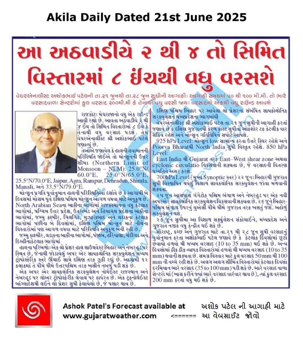
Multiple Rounds of Rainfall Likely Over Saurashtra, Kutch & Gujarat: 21st–28th June 2025
સૌરાષ્ટ્ર, કચ્છ અને ગુજરાતમાં 21થી 28 જૂન 2025 દરમિયાન એકથી વધુ વખત વરસાદ ના રાઉન્ડ ની શક્યતા
Current Weather Conditions – 21st June 2025
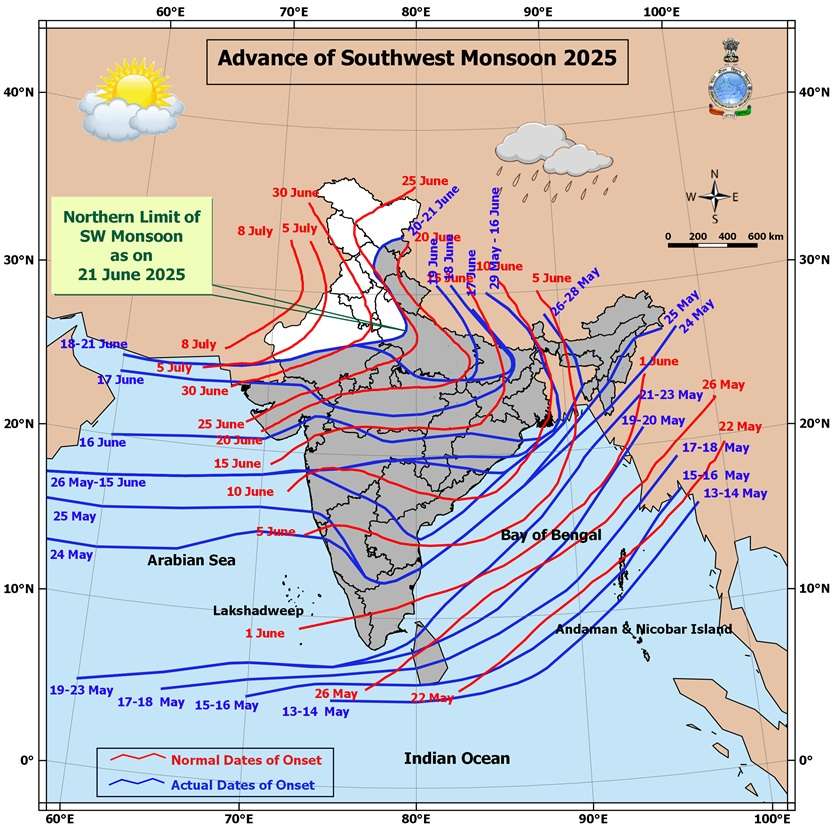
Northern Limit of Monsoon (NLM):
The NLM continues to pass through:
25.0°N/60.0°E, 25.0°N/65.0°E, 25.5°N/70.0°E, Jaipur, Agra, Rampur, Dehradun, Shimla, Manali, and 33.5°N/79.0°E.
Monsoon Progress Outlook:
-
Conditions are favorable for further advance of the Southwest Monsoon over:
-
Remaining parts of North Arabian Sea
-
Additional parts of Rajasthan
-
Remaining parts of West Uttar Pradesh, Uttarakhand, Himachal Pradesh
-
Some parts of Jammu & Kashmir, Gilgit-Baltistan, Muzaffarabad, and Ladakh
in the next 2 days
-
-
Further, conditions are becoming favorable for the monsoon to advance into:
-
Remaining parts of Jammu & Kashmir and Ladakh
-
Some parts of Punjab, Haryana, Chandigarh & Delhi
in the subsequent 2 days -
-
Synoptic Features
-
A Low Pressure Area lies over southwest Bihar & neighborhood, with an associated upper air cyclonic circulation tilting southward with height in the middle tropospheric levels.
It is expected to move slowly northwestward and weaken gradually over the next 12 hours. -
An upper air cyclonic circulation is present over northeast Rajasthan & neighborhood in the lower tropospheric levels.
-
A trough runs from northeast Bangladesh to south Gujarat, passing through:
-
The cyclonic circulation associated with the low pressure area over southwest Bihar
-
Central parts of Madhya Pradesh, in the lower tropospheric levels
-
Expected Weather Parameters
Forecast Period: 21st – 28th June 2025
MSLP (Mean Sea Level Pressure):
-
The off-shore trough along the South Gujarat to Kerala coast is expected to remain active on some days, enhancing monsoon activity.
925 hPa Level:
-
A monsoon low is expected to persist north of normal, remaining positioned over North India throughout the forecast period.
850 hPa Level:
-
An East-West shear zone or cyclonic circulation is likely to develop from East India towards Gujarat, influencing rainfall distribution and intensity.
700 hPa Level (Key Synoptic Layer):
-
22nd June: A broad cyclonic circulation is expected to extend from Bihar to Gujarat.
- Another upper air cyclonic circulation is likely to form over Gangetic West Bengal & neighborhood around 25th June.
-
26th June: The UAC over West Bengal is likely to track westward toward Gujarat. Broad Circulation expected.
-
By 26th/27th June: The broad circulation is expected to shrink and consolidate, becoming more concentrated near Madhya Pradesh and Gujarat.
Rainfall Forecast for Saurashtra, Kutch & Gujarat
Period: 21st to 28th June 2025
-
On some days, light to moderate rainfall (10 to 35 mm) is expected over scattered areas.
-
On other days, fairly widespread rainfall (10 to 35 mm) is likely.
-
Cumulative rainfall during the forecast period may range from 50 mm to 100 mm over most areas (wide spread).
-
Isolated pockets may receive heavy rainfall (35 to 100 mm) on a few days.
-
At select locations, total rainfall could exceed 200 mm during the period, especially where such heavier spells occur.
સૌરાષ્ટ્ર, કચ્છ અને ગુજરાતમાં 21થી 28 જૂન 2025 દરમિયાન એકથી વધુ વખત વરસાદ ના રાઉન્ડ ની શક્યતા
હાલની હવામાન પરિસ્થિતિ – 21st June 2025
મોન્સૂનની ઉત્તર સીમા (Northern Limit of Monsoon – NLM):
NLM નીચેના સ્થળો પરથી પસાર થાય છે:
25.0°N/60.0°E, 25.0°N/65.0°E, 25.5°N/70.0°E, Jaipur, Agra, Rampur, Dehradun, Shimla, Manali, અને 33.5°N/79.0°E.
મોન્સૂન પ્રગતિ પૂર્વાનુમાન:
હાલની પરિસ્થિતિઓ દર્શાવે છે કે આગામી 2 દિવસમાં મોસમ પૂર્વ દક્ષિણ પશ્ચિમ મોન્સૂન આગળ વધવા માટે અનુકૂળ છે:
-
North Arabian Seaના બાકીના ભાગોમાં
-
Rajasthanના વધુ કેટલાક ભાગોમાં
-
West Uttar Pradesh, Uttarakhand, અને Himachal Pradeshના બાકીના ભાગોમાં
-
Jammu & Kashmir, Gilgit-Baltistan, Muzaffarabad, અને Ladakhના કેટલાક ભાગોમાં
પછીના 2 દિવસોમાં, દક્ષિણ પશ્ચિમ મોન્સૂન માટે નીચેના વિસ્તારોમાં પણ આગળ વધવા માટે પરિસ્થિતિ અનુકૂળ બની રહી છે:
-
Jammu & Kashmir અને Ladakhના બાકીના ભાગોમાં
-
Punjab, Haryana, Chandigarh & Delhiના કેટલાક ભાગોમાં
હાલ ના પરિબળો (Synoptic Features):
-
એક Low Pressure Area હાલ southwest Bihar & neighborhood પર સ્થિત છે, જેનાથી જોડાયેલું upper air cyclonic circulation મધ્યમ ટ્રોપોસ્ફેરિક સ્તરે ઊંચાઈ સાથે દક્ષિણ તરફ ઝૂકી રહ્યું છે.
આગામી 12 કલાકમાં તે ધીમે ધીમે ઉત્તરપશ્ચિમ તરફ ખસીને નબળું પડી શકે છે. -
એક upper air cyclonic circulation northeast Rajasthan & neighborhood પર lower tropospheric level પર કાર્યરત છે.
-
એક trough northeast Bangladeshથી લઈને south Gujarat સુધી ફેલાયેલો છે, જે પસાર થાય છે:
-
southwest Bihar પર આવેલા low pressure ના સંબંધિત cyclonic circulation
-
Madhya Pradeshના મધ્યભાગમાંથી
-
અપેક્ષિત હવામાન પરિબળો
અવધિ: 21st – 28th June 2025
MSLP (Mean Sea Level Pressure):
South Gujaratથી Kerala coast સુધીનો off-shore trough કેટલીક વાર સક્રિય રહેશે અને મોન્સૂન ગતિવિધિને સપોર્ટ આપશે.
925 hPa Level:
મોન્સૂન low સામાન્ય કરતા ઉત્તરે સ્થિર રહેશે અને Poorva Bharatથી North India સુધી વિસ્તૃત રહેશે.
850 hPa Level:
East India થી Gujarat તરફ East–West shear zone અથવા cyclonic circulation વિકસવાની શક્યતા છે, જે વરસાદની વિતરણ પધ્ધતિને અસર કરશે.
700 hPa Level (મુખ્ય Synoptic સ્તર):
-
22nd June: Bihar થી Gujarat સુધી વિસ્થાપિત થયેલું વિશાળ cyclonic circulation જોવા મળવાની શક્યતા.
- 25th June આસપાસ Gangetic West Bengal & neighborhood પર એક નવી upper air cyclonic circulation વિકસવાની શક્યતા છે.
-
26th June: Bihar/West Bengal ઉપરનું UAC ધીમે ધીમે Gujarat તરફ ખસતું જશે. બહોળું સર્ક્યુલેશન થશે.
-
27th June સુધીમાં: આ વિશાળ સર્ક્યુલેશન સંકોચાઈને, Madhya Pradesh અને Gujarat નજીક વધુ કેન્દ્રીત થઈ શકે છે.
Saurashtra, Kutch & Gujarat માટે વરસાદનું પૂર્વાનુમાન
અવધિ: 21st to 28th June 2025
-
કેટલાક દિવસોમાં છૂટો છવાયો હળવો થી મધ્યમ વરસાદ (10 to 35 mm) થઈ શકે છે.
-
અન્ય દિવસોમાં ઠીક ઠીક વ્યાપક વિસ્તારોમાં હળવો થી મધ્યમ વરસાદ (10 to 35 mm) થવાની શક્યતા છે.
-
સમગ્ર વિસ્તાર માટે કુલ વરસાદ 50 mm થી 100 mm ની વચ્ચે રહી શકે છે.
-
અલગ અલગ સીમિત વિસ્તારોમાં કેટલાક દિવસો દરમિયાન ભારે વરસાદ (35 to 100 mm) પડી શકે છે.
-
ભારે વરસાદ વાળા સેન્ટરો માં (ખાસ કરીને જ્યાં ભારે વરસાદ વારંવાર થાય છે), ત્યાં કુલ વરસાદ 200 mm કરતાં વધુ થઈ શકે છે.
-
⚠️ Advisory
Caution: Please refer/rely on IMD/RSMC Bulletins/Advisories for Storms & Weather related matter.
સાવચેતી: સ્ટોર્મ કે હવામાન અંગે ની માહિતી માટે ભારતીય હવામાન ખાતા/ગવર્મેન્ટ ના બુલેટીન/સુચના પર નિર્ભર રહેવું.
Read Comment Policy – કમેન્ટ માટે માર્ગદર્શન વાંચો
How To Upload Profile Picture For WordPress – વર્ડપ્રેસ માં પ્રોફાઈલ પિક્ચર કેમ રાખવું
Forecast In Akila Daily Dated 21st June 2025
Forecast In Sanj Samachar Daily Dated 21st June 2025
તારીખ 29 જુન 2025 આજની પરિસ્થિતિ ભારતીય હવામાન વિભાગ અનુસાર મીડ ડે બુલેટિન ➢ નૈઋત્ય નું ચોમાસુ આજે 29 જૂન 2025 ના રોજ રાજસ્થાન, પશ્ચિમ ઉત્તર પ્રદેશ અને હરિયાણાના બાકીના ભાગો અને સમગ્ર દિલ્હીમાં આગળ વધ્યું છે. આમ, તે 29 જૂન, 2025 ના રોજ સમગ્ર દેશને આવરી લે છે, જે સામાન્ય તારીખ 08 જુલાઈ (સમગ્ર ભારતને આવરી લેવાની સામાન્ય તારીખથી 9 દિવસ પહેલા) છે. ➢ લો પ્રેશર આજે 29 જૂન 2025 ના રોજ ભારતીય સમય મુજબ સવારે 08:30 વાગ્યે ઉત્તર પશ્ચિમ બંગાળની ખાડી અને તેની આસપાસના પશ્ચિમ બંગાળ અને બાંગ્લાદેશ દરિયાકાંઠા પર છે. તેનુ આનુષાંગિક UAC સરેરાશ સમુદ્ર સપાટીથી 7.6 કિમી… Read more »
Sir badha aagahi kar kahe chhe 26 thi weat saurashtra ma jordar varsad chalu Thai jase pan windy ma kyay 5 Divas varsad nu kai batavtu nathi to shu west saurashtra ma hji rah jovo pad chhe
Wunderground ma check karo. Andaj aavashe
Wunderground ma jam kandorana aave ke nhi
Your location select karo
Vadodara na amuk vistaaro ma dhodhmar varsad chalu ane baki na areas ma madhyam varsad chalu
Ajj vatavaran chokhu thayu che.
Sir maro ek prasna che jyare Akash chokhu thayu tyare cloud forming and high humidity cloud ne saru condensation provide kare che ne?
Yes bija varsad na round mate taiyari thay che. Pure Gujarati language ma kahie to navo maal taiyar thay che. Pan Vadodara ma to atyare varsad chaluj che full etle tamare pan aje sanjhe Kem vaaro avi jase.
Varo ave to bau saru kemke Khali chanta chuti thay che last week thi
Aavi gayo ne vaaro aje sanjh pachi tamaro.. saro varsad padyo tamare
Aaje grmi vdhi che….upar thi tadko nikdo che so fingers crossed 🙂
Baki chokkhu vatavaran……..clouds forming ane condensation mate to vatavaran saru hovu joi….jem k humidity + other good conditions and systems near around….as per my knowledge
Tarikh 30 june suthi varasadi vatavaran saru rese all gujarat mate.
Kd bhai July mahinama aagla divsoma kevu rese
Jsk rajesh bhai…….hal aavu, joye aagad have.
૨૯ જૂન પછી પણ વરસાદી માહોલ છે !બધાનો વારો આવશે!
Vyara ma dhimi dhare chaluj varsad che
જયશ્રી કૃષ્ણ સર , મિત્રો મોજ કરો , સર આ વખતે લાંબુ ચાલસે , સિસ્ટમને ક્યાંય નીકળવા ની જગ્યા દેખાતી નથી , આખા દેશમાં સામ સામુ દબાણ છે, એટલે બધાનો વારો આવી જસે , સુર્ય દેવ પણ લાંબા ટાઈમે દર્શન આપસે એવુ લાગે છે
સર bfs મોડેલ લોન્ચ કર્યું ૨૬ જૂને ત્યાર પછી તેનું forcast સચોટ રહ્યું છેલા બે દિવસ બરાબર નથી રહ્યા તે કેટલા વાગ્યે અપડેટ થાય છે
Time by 12 bapore
Check karay kalake kalake
સર ગઈ કાલે સાંજે 5 વાગ્યાથી ધીમો મધ્યમ વરસાદ ચાલુ છે
Sri ashok patel lmd GFS UTC krtli kalake update thay 6e
Dar 12 kalake 10 divas and dar vache 06 UTC and 18 UTC 3 divas maate
સર તમે મગફળી નું વાવેતર વાવેતર કર્યૂછે
Yes
Mathe 2 divas varsad chhe
અમારે પણ બે દિવસ વરસાદ થયો વાવણી વાવ્યા ઉપર
Saheb amne aa round no labh madse ??
Ahmedabad Dholka
5 vagya thi dhimidhare pachi
Adhi kalak thi gajvij jode zordar varsad
Gota area Sg Highway ,Amdavad ma sanj no dhimi dhare Varsad chalu.
Sar Amara dhrol no varo avshe amari rada japta chha
Vadodara ma chella 2 kallak thi gajvij sathe dhodhmar varsad
Mehta bhai amaro varo aava dyo have……
Aavi jase tamaro pan vaaro Dhirenbhai chinta na karo. Chomasu aa vakhate June mahina thij ekdam active che..
Dar roj atla vadada thay che but varsad nai avto hath tadi apni ne jato re chhe
Rainfall data update karo Last
Vadodara ghana vistaar ma 1/2 thi 4 inch varsaad
તારીખ 24 જુન 2025 આજની પરિસ્થિતિ ભારતીય હવામાન વિભાગ અનુસાર મીડ ડે બુલેટિન ➢ નૈઋત્ય નું ચોમાસું આજે ઉત્તર અરબી સમુદ્રના બાકીના ભાગો, પશ્ચિમ ઉત્તર પ્રદેશના કેટલાક ભાગો, હરિયાણાના કેટલાક ભાગો; ચંદીગઢ, હિમાચલ પ્રદેશ અને જમ્મુના બાકીના ભાગો અને પંજાબના કેટલાક ભાગોમાં આગળ વધ્યું છે. ➢ નૈઋત્ય ના ચોમાસાની રેખા હવે 25.0°N/60.0°E, 25.0°N/65.0°E, 25.5°N/70.0°E, બાડમેર, જોધપુર, જયપુર, આગ્રા, રામપુર, બિજનોર, કરનાલ, હલવારા અને 33.0°N/70.5°E માંથી પસાર થાય છે. ➢ નૈઋત્ય નું ચોમાસું આગામી 36 કલાક દરમિયાન રાજસ્થાન, પંજાબ, હરિયાણા; દિલ્હી અને પશ્ચિમ ઉત્તર પ્રદેશના બાકીના ભાગોમાં નૈઋત્ય નું ચોમાસું વધુ આગળ વધવા માટે પરિસ્થિતિઓ અનુકૂળ છે. ➢ એક UAC દક્ષિણ… Read more »
Extremely heavy Rain in entire panchmahal dist since 1.00 afternoon
Vadodara ma atyare ek kallak thi gajvij sathe madhyam varsad chalu
Upleta ma atyare 2 vagye Suraj Dada na Darshan thaya che
Light rains in dholka
પ્રણામ ગુરૂજી
આ રાઉન્ડ માં ઢસા વિસ્તારમાં તા 23 સુધી મા ઝરમર હળવો મધ્યમ વરસાદ અંદાજે 1 ઇંચ થી 2.50 ઇંચ વરસાદ વિસ્તાર પ્રમાણે હતો
હવે પછી ના સમય ગાળા મા બંગાળ ની સિસ્ટમ સિયરજોન બહોળુ સરકયુલેશન ટ્ફ વિગેરે પરિબળો ની અસર થી તા 30 સુધી મા સારો ભારે વરસાદ આવશે એવું બધા મોડલો જોતા લાગે છે
મુખ્ય વિસ્તાર વડોદરા થી ભાવનગર રાજકોટ જામનગર પોરબંદર દ્વારકા પટી પૂર્વ થી પશ્ચિમ અને સુરેન્દ્રનગર બોટાદ ઢસા જસદણ અમરેલી કુડલા પટી ઉત્તર થી દક્ષિણ રહશે
તમારા બહોળા અનુભવ અનુસાર
જણાવવા આપશ્રી ને નમ્ર વિનંતી
Aje East central Gujarat no varo avse evu Lage che…
Savare thi cloud movement sari chhe
Sab aaj thi varsad ni matra dhatse?
Ghatse
Varsad hamna roj ocha vadhta pramaan ma chaluj rese
Sir,aa round ma varsad anticlockwise faryo hoy avu lagyu.
North Gujarat thi Kutch thai ne Saurashtra ane South Gujarat pachi Central Gujarat ane have fari North Gujarat baju avse avu lage chhe.
UAC aamaj fartu hoy !
Bhai kutchh ne bypass karyo che Baki badhe faryo varsad
Sir date 27/06 to 30/06/2025 sudhi madhyapradesh na ujjain Ane indore ma kevo varshad rehase? Mare javanu che
Javab apso sir
Wunderground ma jovo
Surat ma ghana varsh pachi aavi jordar varsad joyo ashokbhai haju dhimi dhare chalu che lagbhag 15 inch thava aavyo gaikal ne atyar sudhi no.
Sir.mare aavti date 2 thi 10 ma Kutch ma family sathe gadi lay ne farva javu che to tyare varsad nu kevu rahese…javay ke n javay…
Hu LGAKN
Andaj mate..lambhu to che j..
30 તારીખ થી વિન્ડી માં અનુમાન કરી લો
50% અંદાજ આવી જશે
સુરત શહેર ના રાત્રી ના 12 થી સવાર ના 6 વાગ્યા સુધી ના આંકડા
Center zone 104 mm
East zone A 159 mm
East zone. B 127 mm
West zone 98 mm
North zone 91 mm
South zone 28 mm
South east zone 100 mm
South west zone 44 mm
આ લખાય છે ત્યારે સુરત માં મધ્યમ વરસાદ ચાલુ છે.
Surat 346 in 24 hours.
Kamrej 272 in 24 hours.
Ahi Rainfall Data update thayel chhe.
સુરત શહેર માં અત્યારે તોફાની વરસાદ ચાલુ છે..!
આ આંકડા સુરત ના વરાછા ના યોગીચોક,સીમાડા અને સરથાણા વિસ્તાર ના છે છેલ્લા 24 કલાક ના
હું સુરત માં છેલ્લા 14 વર્ષ થી છું પણ છેલ્લે આવો વરસાદ 2012 કા 2013 માં જોયો હતો અને આજ નો વરસાદ ઓરીજનલ દક્ષિણ ગુજરાત ના કપરાડા ધરમપુર સ્ટાઇલ માં હતો
Kya app
More than 2 inches rainfall in dholka
Again under reporting
Dholke me barish to kafi hoti h par akde bhai kam dikhate he
સાચી વાત છે કાલે બપોરે 12 થી 2 માં 2 થી 3 ઇંચ વરસાદ થયો પરંતુ આંકડા માં ભૂલ થતી હોય એવું લાગે છે
Amuk vistar rahi jata hoy ane rain mapvanu centre tyaj hoy evu lage che
આ વર્ષે જામ ખંભાળીયા અને કલ્યાણ પુર તાલુકાના ગ્રામ્ય વિસ્તારમાં 10 to 35 mm નો રાઉન્ડ જ ભાગ માં આવે છે
સર તમારી આગાહી મુજબ એક થી વધુ રાઉન્ડ આવી શકે તો અમારે તારીખ. ૨૨.૨૩મા બે રાઉન્ડ આવી ગયા પાણજોગ તો હવે વરસાદ માં કાલથી ઘટાડો જોવા મળશે
25th June આસપાસ Gangetic West Bengal & neighborhood પર એક નવી upper air cyclonic circulation વિકસવાની શક્યતા છે.
26th June: Bihar/West Bengal ઉપરનું UAC ધીમે ધીમે Gujarat તરફ ખસતું જશે. બહોળું સર્ક્યુલેશન થશે.
27th June સુધીમાં: આ વિશાળ સર્ક્યુલેશન સંકોચાઈને, Madhya Pradesh અને Gujarat નજીક વધુ કેન્દ્રીત થઈ શકે છે.
Vadodara ma 4 vagya no light gajvij sathe madhyam thi bhare varsad constant chalu. Alag alag vistaro ma juda juda pramaan ma varsad
Sir, IMD Ahmedabad nu Rain Radar khotkayu chhe ke su?
Hu bahar chhu
Jasdan ma reda chhe khali
sar dem storej na deta hoy to apdet karo ne
https://wrd.guj.nic.in/dam/
લીંક સાચવજો.
Sir rajkot ma varshad na chans kharo ke have aamaj rese ans please
હળવદ વાળા બોલજો
એક UAC સૌરાષ્ટ્ર અને કચ્છ પર છે અને તે સરેરાશ સમુદ્ર સપાટીથી 3.1 કિમી પર છે. ano સૌરાષ્ટ્ર અને કચ્છ ne faydo thay ???????
કાલે ઝરમર ઝરમર અડધો ઇંચ દિવસનો વરસાદ અને રાતે પણ અડધો ઇંચ અને આજે પણ સવારનો ધીમીધારે વરસાદ શરૂ છે હવે આ વરસાદ બંધ નહીં થાય તો કપાસિયા ઉગેલા બળી જશે. તો સર આ વરસાદ હવે ક્યારે બંધ થશે. હવે બે ત્રણ દિવસ વરાપ નીકળે તો સારું
Cyclonic Circulation over Saurashtra and Kutch, so with this system rainfall intensity increases?
Je thavanu hoy te paribad joyel hoy.
Ahmedabad Dholka
12:30 thi 2 vagya sudhi gajvij jode Dodhmar varsad hto
સાહેબ ના અનુભવ ને સલામ છે….
Wankaner vistar na gramy.saro varsad chalu che
તારીખ 23 જુન 2025 આજની પરિસ્થિતિ ભારતીય હવામાન વિભાગ અનુસાર મીડ ડે બુલેટિન ➢ નૈઋત્ય ના ચોમાસાની રેખા 25.0°N/60.0°E, 25.0°N/65.0°E, 25.5°N/70.0°E, જયપુર, આગ્રા, રામપુર, દેહરાદૂન, શિમલા, પઠાણકોટ, જમ્મુ અને 33.5°N/73.0°E અને 34.0°N/71.0°E માંથી પસાર થાય છે. ➢ નૈઋત્ય નું ચોમાસું આગામી 2 દિવસ દરમિયાન ઉત્તર અરબી સમુદ્રના બાકીના ભાગો, રાજસ્થાનના કેટલાક ભાગો, પંજાબ, હરિયાણા, ચંદીગઢ અને દિલ્હીના કેટલાક ભાગો, પશ્ચિમ ઉત્તર પ્રદેશના બાકીના ભાગો, હિમાચલ પ્રદેશ અને જમ્મુના બાકીના ભાગો પર નૈઋત્ય નું ચોમાસુ આગળ વધવા માટે પરિસ્થિતિઓ અનુકૂળ છે. ➢ દક્ષિણપૂર્વ ઉત્તર પ્રદેશ અને તેના આસપાસના વિસ્તાર પર નુ UAC હવે દક્ષિણ ઉત્તર પ્રદેશના મધ્ય ભાગો પર છે અને… Read more »