Multiple Rounds of Rainfall Likely Over Saurashtra, Kutch & Gujarat: 21st–28th June 2025
સૌરાષ્ટ્ર, કચ્છ અને ગુજરાતમાં 21થી 28 જૂન 2025 દરમિયાન એકથી વધુ વખત વરસાદ ના રાઉન્ડ ની શક્યતા
Current Weather Conditions – 21st June 2025
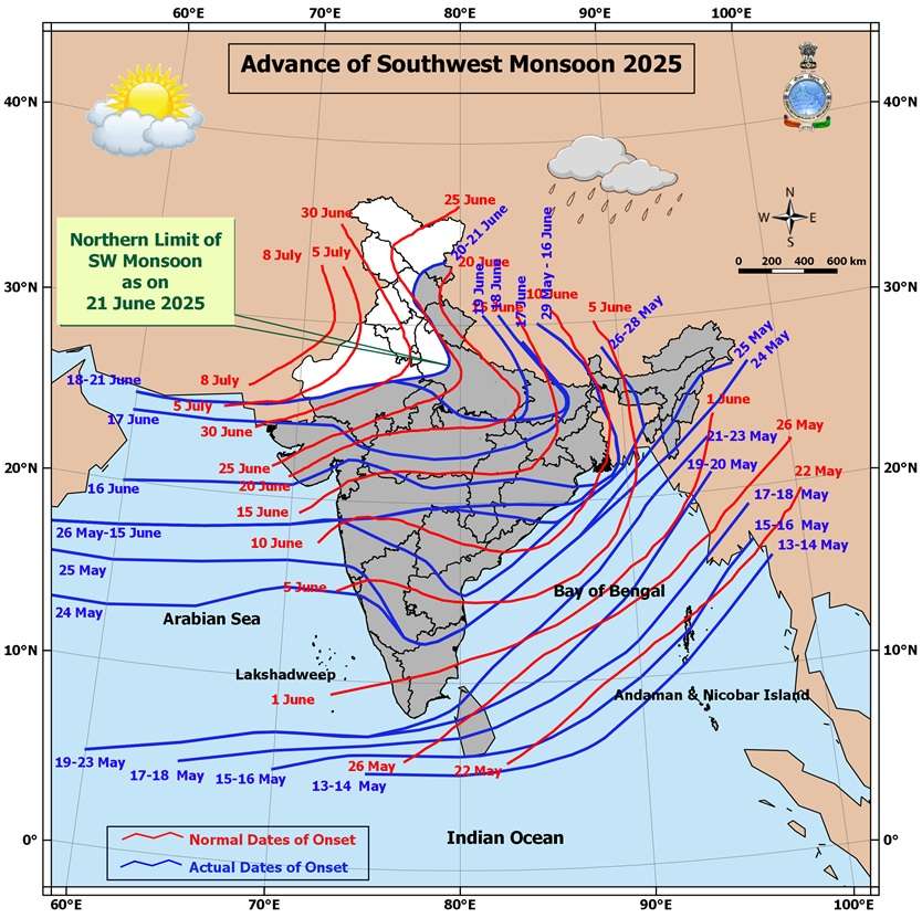
Northern Limit of Monsoon (NLM):
The NLM continues to pass through:
25.0°N/60.0°E, 25.0°N/65.0°E, 25.5°N/70.0°E, Jaipur, Agra, Rampur, Dehradun, Shimla, Manali, and 33.5°N/79.0°E.
Monsoon Progress Outlook:
-
Conditions are favorable for further advance of the Southwest Monsoon over:
-
Remaining parts of North Arabian Sea
-
Additional parts of Rajasthan
-
Remaining parts of West Uttar Pradesh, Uttarakhand, Himachal Pradesh
-
Some parts of Jammu & Kashmir, Gilgit-Baltistan, Muzaffarabad, and Ladakh
in the next 2 days
-
-
Further, conditions are becoming favorable for the monsoon to advance into:
-
Remaining parts of Jammu & Kashmir and Ladakh
-
Some parts of Punjab, Haryana, Chandigarh & Delhi
in the subsequent 2 days -
-
Synoptic Features
-
A Low Pressure Area lies over southwest Bihar & neighborhood, with an associated upper air cyclonic circulation tilting southward with height in the middle tropospheric levels.
It is expected to move slowly northwestward and weaken gradually over the next 12 hours. -
An upper air cyclonic circulation is present over northeast Rajasthan & neighborhood in the lower tropospheric levels.
-
A trough runs from northeast Bangladesh to south Gujarat, passing through:
-
The cyclonic circulation associated with the low pressure area over southwest Bihar
-
Central parts of Madhya Pradesh, in the lower tropospheric levels
-
Expected Weather Parameters
Forecast Period: 21st – 28th June 2025
MSLP (Mean Sea Level Pressure):
-
The off-shore trough along the South Gujarat to Kerala coast is expected to remain active on some days, enhancing monsoon activity.
925 hPa Level:
-
A monsoon low is expected to persist north of normal, remaining positioned over North India throughout the forecast period.
850 hPa Level:
-
An East-West shear zone or cyclonic circulation is likely to develop from East India towards Gujarat, influencing rainfall distribution and intensity.
700 hPa Level (Key Synoptic Layer):
-
22nd June: A broad cyclonic circulation is expected to extend from Bihar to Gujarat.
- Another upper air cyclonic circulation is likely to form over Gangetic West Bengal & neighborhood around 25th June.
-
26th June: The UAC over West Bengal is likely to track westward toward Gujarat. Broad Circulation expected.
-
By 26th/27th June: The broad circulation is expected to shrink and consolidate, becoming more concentrated near Madhya Pradesh and Gujarat.
Rainfall Forecast for Saurashtra, Kutch & Gujarat
Period: 21st to 28th June 2025
-
On some days, light to moderate rainfall (10 to 35 mm) is expected over scattered areas.
-
On other days, fairly widespread rainfall (10 to 35 mm) is likely.
-
Cumulative rainfall during the forecast period may range from 50 mm to 100 mm over most areas (wide spread).
-
Isolated pockets may receive heavy rainfall (35 to 100 mm) on a few days.
-
At select locations, total rainfall could exceed 200 mm during the period, especially where such heavier spells occur.
સૌરાષ્ટ્ર, કચ્છ અને ગુજરાતમાં 21થી 28 જૂન 2025 દરમિયાન એકથી વધુ વખત વરસાદ ના રાઉન્ડ ની શક્યતા
હાલની હવામાન પરિસ્થિતિ – 21st June 2025
મોન્સૂનની ઉત્તર સીમા (Northern Limit of Monsoon – NLM):
NLM નીચેના સ્થળો પરથી પસાર થાય છે:
25.0°N/60.0°E, 25.0°N/65.0°E, 25.5°N/70.0°E, Jaipur, Agra, Rampur, Dehradun, Shimla, Manali, અને 33.5°N/79.0°E.
મોન્સૂન પ્રગતિ પૂર્વાનુમાન:
હાલની પરિસ્થિતિઓ દર્શાવે છે કે આગામી 2 દિવસમાં મોસમ પૂર્વ દક્ષિણ પશ્ચિમ મોન્સૂન આગળ વધવા માટે અનુકૂળ છે:
-
North Arabian Seaના બાકીના ભાગોમાં
-
Rajasthanના વધુ કેટલાક ભાગોમાં
-
West Uttar Pradesh, Uttarakhand, અને Himachal Pradeshના બાકીના ભાગોમાં
-
Jammu & Kashmir, Gilgit-Baltistan, Muzaffarabad, અને Ladakhના કેટલાક ભાગોમાં
પછીના 2 દિવસોમાં, દક્ષિણ પશ્ચિમ મોન્સૂન માટે નીચેના વિસ્તારોમાં પણ આગળ વધવા માટે પરિસ્થિતિ અનુકૂળ બની રહી છે:
-
Jammu & Kashmir અને Ladakhના બાકીના ભાગોમાં
-
Punjab, Haryana, Chandigarh & Delhiના કેટલાક ભાગોમાં
હાલ ના પરિબળો (Synoptic Features):
-
એક Low Pressure Area હાલ southwest Bihar & neighborhood પર સ્થિત છે, જેનાથી જોડાયેલું upper air cyclonic circulation મધ્યમ ટ્રોપોસ્ફેરિક સ્તરે ઊંચાઈ સાથે દક્ષિણ તરફ ઝૂકી રહ્યું છે.
આગામી 12 કલાકમાં તે ધીમે ધીમે ઉત્તરપશ્ચિમ તરફ ખસીને નબળું પડી શકે છે. -
એક upper air cyclonic circulation northeast Rajasthan & neighborhood પર lower tropospheric level પર કાર્યરત છે.
-
એક trough northeast Bangladeshથી લઈને south Gujarat સુધી ફેલાયેલો છે, જે પસાર થાય છે:
-
southwest Bihar પર આવેલા low pressure ના સંબંધિત cyclonic circulation
-
Madhya Pradeshના મધ્યભાગમાંથી
-
અપેક્ષિત હવામાન પરિબળો
અવધિ: 21st – 28th June 2025
MSLP (Mean Sea Level Pressure):
South Gujaratથી Kerala coast સુધીનો off-shore trough કેટલીક વાર સક્રિય રહેશે અને મોન્સૂન ગતિવિધિને સપોર્ટ આપશે.
925 hPa Level:
મોન્સૂન low સામાન્ય કરતા ઉત્તરે સ્થિર રહેશે અને Poorva Bharatથી North India સુધી વિસ્તૃત રહેશે.
850 hPa Level:
East India થી Gujarat તરફ East–West shear zone અથવા cyclonic circulation વિકસવાની શક્યતા છે, જે વરસાદની વિતરણ પધ્ધતિને અસર કરશે.
700 hPa Level (મુખ્ય Synoptic સ્તર):
-
22nd June: Bihar થી Gujarat સુધી વિસ્થાપિત થયેલું વિશાળ cyclonic circulation જોવા મળવાની શક્યતા.
- 25th June આસપાસ Gangetic West Bengal & neighborhood પર એક નવી upper air cyclonic circulation વિકસવાની શક્યતા છે.
-
26th June: Bihar/West Bengal ઉપરનું UAC ધીમે ધીમે Gujarat તરફ ખસતું જશે. બહોળું સર્ક્યુલેશન થશે.
-
27th June સુધીમાં: આ વિશાળ સર્ક્યુલેશન સંકોચાઈને, Madhya Pradesh અને Gujarat નજીક વધુ કેન્દ્રીત થઈ શકે છે.
Saurashtra, Kutch & Gujarat માટે વરસાદનું પૂર્વાનુમાન
અવધિ: 21st to 28th June 2025
-
કેટલાક દિવસોમાં છૂટો છવાયો હળવો થી મધ્યમ વરસાદ (10 to 35 mm) થઈ શકે છે.
-
અન્ય દિવસોમાં ઠીક ઠીક વ્યાપક વિસ્તારોમાં હળવો થી મધ્યમ વરસાદ (10 to 35 mm) થવાની શક્યતા છે.
-
સમગ્ર વિસ્તાર માટે કુલ વરસાદ 50 mm થી 100 mm ની વચ્ચે રહી શકે છે.
-
અલગ અલગ સીમિત વિસ્તારોમાં કેટલાક દિવસો દરમિયાન ભારે વરસાદ (35 to 100 mm) પડી શકે છે.
-
ભારે વરસાદ વાળા સેન્ટરો માં (ખાસ કરીને જ્યાં ભારે વરસાદ વારંવાર થાય છે), ત્યાં કુલ વરસાદ 200 mm કરતાં વધુ થઈ શકે છે.
-
⚠️ Advisory
Caution: Please refer/rely on IMD/RSMC Bulletins/Advisories for Storms & Weather related matter.
સાવચેતી: સ્ટોર્મ કે હવામાન અંગે ની માહિતી માટે ભારતીય હવામાન ખાતા/ગવર્મેન્ટ ના બુલેટીન/સુચના પર નિર્ભર રહેવું.
Read Comment Policy – કમેન્ટ માટે માર્ગદર્શન વાંચો
How To Upload Profile Picture For WordPress – વર્ડપ્રેસ માં પ્રોફાઈલ પિક્ચર કેમ રાખવું
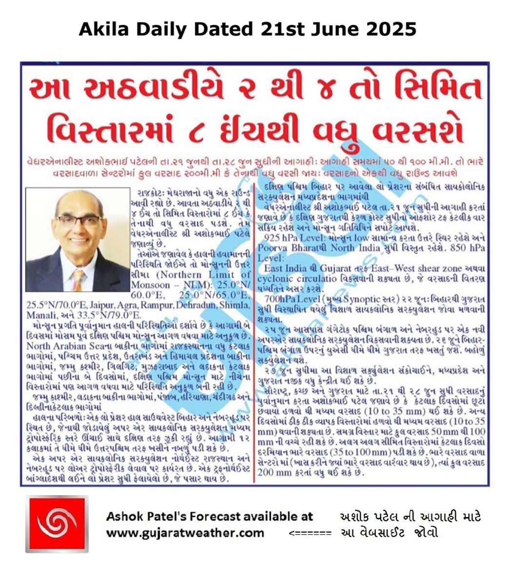
Forecast In Akila Daily Dated 21st June 2025
Forecast In Sanj Samachar Daily Dated 21st June 2025
તારીખ 29 જુન 2025 આજની પરિસ્થિતિ ભારતીય હવામાન વિભાગ અનુસાર મીડ ડે બુલેટિન ➢ નૈઋત્ય નું ચોમાસુ આજે 29 જૂન 2025 ના રોજ રાજસ્થાન, પશ્ચિમ ઉત્તર પ્રદેશ અને હરિયાણાના બાકીના ભાગો અને સમગ્ર દિલ્હીમાં આગળ વધ્યું છે. આમ, તે 29 જૂન, 2025 ના રોજ સમગ્ર દેશને આવરી લે છે, જે સામાન્ય તારીખ 08 જુલાઈ (સમગ્ર ભારતને આવરી લેવાની સામાન્ય તારીખથી 9 દિવસ પહેલા) છે. ➢ લો પ્રેશર આજે 29 જૂન 2025 ના રોજ ભારતીય સમય મુજબ સવારે 08:30 વાગ્યે ઉત્તર પશ્ચિમ બંગાળની ખાડી અને તેની આસપાસના પશ્ચિમ બંગાળ અને બાંગ્લાદેશ દરિયાકાંઠા પર છે. તેનુ આનુષાંગિક UAC સરેરાશ સમુદ્ર સપાટીથી 7.6 કિમી… Read more »
Sir
Heavy rain in surat city 7:15am to 1:30pm 7″ inch somthing, midium rain haju chalu j chhe.
Aa rawund ma nava Aagahi karva vada rakhdi padya.. ashok sar No.1
Kaymi ne mate Gujrat wether ni savari salamati ni savari.
Sir surat thi mara mitro no msg hato bov varsad che Comrcial complex na celro bhari didha nuksan bov hase
Sir mare aavu lakhelu aave che badhi try kari
Browser change karo
24 kalak thi parmar varshad damnagar gariyadhar na gamoma
Sar sistam hal Kiya ce paschim savrast upar ce
Freemetyo mare ke nay khultu hoy koy janav so please
Freemeteo Rajkot
Search ma tamaru gaam nakho
Free meteo app nai khule web kholo
30 minit thi saro varsad salu se
Surat 7 to 8 inch rainfall in 2 hours
Uditrajsinh Solanki – SURAT
Kai Varsad hoy toe janavajo !!!
Sir savare 7 vagya thi satat 11 vagya suthi saro varsad padiya surat City na anek jagya a pani bharana che haju gajvij sadhe dhimo varsad chalu che
Haha,atyare enjoy karva dyo tadko aavse etle aavse!
Amare bharuch ma saro varsad pdyo
સુરત માં સવાર ના સાત વાગ્યા થી બપોર બે વાગ્યા સુધી માં 9 ઈંચ વરસાદ પડ્યો કોમશીયલ બિલ્ડીંગ નાં બેઝમેન્ટ માં પાણી ઘુસી ગયા ઘણું નુકશાન છે
Ecmwf kai khaas notu dekhadtu Ane gai kaale Jamnagar, Junagadh, Porbandar, Rajkot ma ghani jagaye bhaare varsad varsi gayo. 100% correct prediction by Sir.
Jsk Anubhavi mitro, Vatavran bantu aave che. Bopor pachi west saurashtra ne labh madse evu lage che ? mahiti aapjo
Upleta ma Kale savarna 9 thi Ratna 8 sudhi medium varsad hato aaje 23 tarikhe Shanti che bapor baad kai navu thay to nakki nahi
Kale amare 30mm varsad adyo katake katake. Mosam no total 158 mm.
અમારે તો વાવણી પછી ઝરમર વરસાદ છે નથી સારો આવતો કે નથી વરાપ દેતો કઈ કામ પણ નથી કરવા દેતો
Sir amare ajno varsad 80 mm…atyare viram chhe…!
Namste Sir amare gai kale sanje 5:00 vage chalu thayo hato varsad…aaje savare 8 9 avgya jevo bandh Thayo talavo nadi Nala Chhalkay gya…
Sir jodiya ma aje no ketlo varsad chhe kem ke stanik akda mujab 6:30 inch kahe chhe
સર, તમે ભારે વરસાદ વારંવાર થાય શબ્દ નો ઉલ્લેખ કર્યો તે વિસ્તાર ડાંગ, સાપુતારા જેવા દક્ષિણ ગુજરાત ના વિસ્તાર કે ??
કે પછી હમણાં અમારે ૧૬/૧૭ જુને પડ્યો એ વિસ્તાર અમરેલી, ભાવનગર જિલ્લાના??
Chalu athvadiye je bhare varsad thay teni vaat chhe
સર આજે સારો વરસાદ થઈ ગયો 2″+ હશે
Sir, Dhoraji ma total 3 Ench
આજે બપોરે ના ૨:૦૦ વાગ્યે થી સાંજે ૭:૦૦ વાગ્યા સુધીમાં ઓછામાં ઓછો ૫ થી ૬ ઈંચ વરસાદ પડી ગયો. ફુલ મોજ…
જામનગર જિલ્લા ના જોડીયા તાલુકા માં વરસાદ દે ભૂકા બોલાવી દીધા સાત ઈંચ હજુ કન્ટીન્યૂ
Devraj bhai 7 vaga pacchi dhimo padi gayo hato ane 8 vage sav viram lidhi
Jetalsar ma aaj no 2ich varsad
સર આજે બપોર ના 1 થી 4 વાગ્યા સુધી માં જોરદાર ગાજવીજ સાથે 125 mm વરસાદ
Sir amare khub saro varsad padi rahiyo che.kyarek dhimo to kyarek ful…
Sir
Aaj no varsad 6.5 inch
Has sir have varsad dhimo padyo keshod ma…. Jay shree radhe krishna ji….
Sir amare aajno 2inch+ varsad avi gayo haju dhimidhare chalu chhe sir a vakhate imd gfs sachot sabit thayu brobar ne sir
sar agahi amay ma mansun rekha dakshin Rajasthan sudhi avse
Yes
sar te ketli niche sudhi svse
Gujarat par
Jsk સર…. તો તાં ઉત્તર અને પક્ષિમ સૌરાષ્ટ્ર ની ખો નીકળી જાહે કે હું સર?
Padodar…bapor na 1.30 thi sanja na 6.30 sudhi ma 80 mm varsad .. taluka…. keshod…jillo…. Junagadh
Jsk સર… 4 વાગ્યા થી ધીમી ધારે.. રેડે રેડે વરસાદ ચાલુ શે અમારે
Mitro forcast mujab 28k nu kachu sonu varahi rahiyu che……….
Amare atiyare jamnagar ma lagbhag 4 ka 4.30 no chalu thyo che dhimo normal gajtoto tyare
Atiyare 1 kalak thi full dhodhmar ave che
ગયા વર્ષે જ્યાં જ્યાં ઓછો વરસાદ હતો ત્યાં આ વર્ષે શરૂઆત સારી થઈ છે. દરેક શહેર ના વરસાદ ના આંકડા નો ડેટા પહેલા ની જેમ rain fall data માં કેમ નથી આવતો..ફક્ત 24 કલાક વાળો જ આવે છે. આ સિઝન ના કુલ વરસાદ ના આંકડા નથી આવતા.
Data aapel chhe
24 hours Daily Rainfall jovo
સૌરાષ્ટ્રમાં કેટલા દિવસ શક્યતા છે?
Sar 3 ins aajno padigayo hase
Sir peli var imd gfs bija model karta vdahu sachot sabit thayu varsad ma a round mate
Sir keshodma meghtandav jevo varsad pade chhe jane ke badha level mathi varsad pade chhe keshod upar…. Jay Shree Radhe Krishna Ji….
Supedi ma savare 8.30 vagya no chalu che varsad kyrek dhimo kyrek full
સર અમે તો પેલા જ દિવસે 50mm થી 100mm નિ વચ્ચે આવી ગયા આજે ખુબ જ ધોધમાર વરસાદ પડે છે અમારા કેશોદ વિસ્તારમાં એવુ લાગે છે કે અમને આજે જ 200mm ઉપર પહોંચાડી દેશે.
અશોક સર એક કલાક થી ધોધમાર વરસાદ ચાલુ અલિયાબાડાં
12.30 thi 5 dhimi dhare andaje 3inch thi vadhu
Amare 10 am thi dhimi dhare varasad chalu se 1″+ thai giyo
શ્રી અશોકભાઈ નમસ્તે!
જય શ્રીકૃષ્ણ જય ઉમિયાજી
અમારે વડાળી લગભગ પચાસ મિનિટ થયા સારો વરસાદ ચાલુ છે
અત્યારે પણ ચાલુ છે
આભાર
Sir amare 1 inch thi vadhu varsad 3.30 thi 4.30 pm sudhi
12 vagya thi satat vadhti zadap sathe… Continue chalu zordar….3.15 in.hju pan dhodhmar chalu
Sar rainfall data updat karo ne
Sir 30 minit thya sara reda chalu che gaj vij hare.
Thanks for new update sir
એક કલાક થો ધીમી ધારે વરસાદ પડી રહ્યો છે
11vageya thi Chali