Current Weather Conditions on 30th July 2013 @ 2.00 pm.
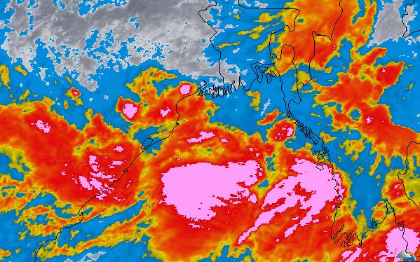
Yesterday’ Low Pressure over Northeast Bay of Bengal tracked Westwards and has strengthened to a Depression this morning over Northwest Bay of Bengal and adjoining areas of West Bengal & North Odisha centered at 21.0 N. & 88.5 E. about 75 Kms. East of North Odisha Coast. System is expected to track West Northwest and cross Odisha Coast by tonight.
Wunderground Map showing Clouding Associated with the Depression
30-07-2013 @ 11.30 IST.
Squally winds speed reaching 45-55 kmph gusting to 65 kmph would prevail along
and off Odisha coast during next 48 hrs. Sea condition will be rough to very rough along and
off Odisha coast during this period.
System initially expected to track West Northwestwards over Odisha, Chhhatishgarh
& Vidarbha and M.P. border areas.
Under the influence of this system, rainfall would occur at most places over Odisha,
Chattisgarh and Vidharba with heavy to very heavy falls at a few places during next 48 hours .
Extremely heavy falls would also occur at isolated places over Odisha during next 24 hrs.
Updates of its effect on Saurashtra, Gujarat & Rajasthan will be given tomorrow.
Weather Forecast In Akila Daily dated 30th July 2013

.