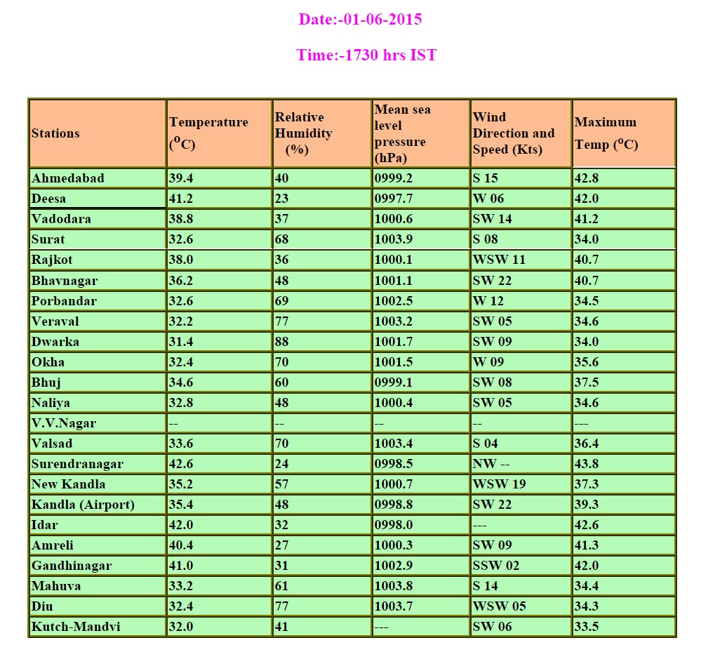
Maximum Temperature over Saurashtra & Gujarat have maintained the 41-44 range over some centers. Surendranagar recorded 43.8 C, Ahmedabad 42.8 C, & Gandhinagar/Deesa 42.0 C on 1st June 2015.
A Western Disturbance is now located over Pakistan and North India. There is an induced UAC over Central Pakistan & adjoining West Rajasthan extending up to 1.5 Kms. above mean sea level.
There is an UAC in the Bay Of Bengal off the South Andhra Pradesh Coast between 2.1 Kms. to 3.6 Kms. above mean sea level.
There is an UAC over Lakshadweep area & vicinity between 3.1 Kms. & 5.8 Kms. above mean sea level.
The Maximum Temperature today for locations over Saurashtra, Gujarat & Kutch were as follows :
The number of Hot Centers (Major) Of India 45.0 C and above have decreased today
Daltonganj (India) 45.4 °C
Jaisalmer (India) 45.4 °C
Gaya (India) 45.3 °C
Forecast: 1st June to 5th June 2015
Saurashtra, Gujarat & Kutch:
The Maximum temperature will come down between 2nd June to 4th June over Saurashtra, Gujarat & Kutch by 1 to 3 C. The afternoon/evening humidity is expected to increase further thereby increasing the Heat Index. Generally there will be windy weather on 2nd June.
Upper level trough associated with the Western Disturbance is expected to deep down from Rajasthan to over Saurashtra, Gujarat & Kutch on 3rd-4th June. There is 50% possibility of scattered showers over Saurashtra, Gujarat & Kutch on 3rd-4th June.
Maximum Temperature could inch up again on 5th June.
Rest Of India :
Hot weather areas will decrease till 4th June over most States of North India, Central India and Adjoining States. The Maximum Temperature as well as areas will increase on 5th June, especially over North India.
Due to Western Disturbance there will be light to medium rain over North India including Rajasthan on 1st to 3rd June.
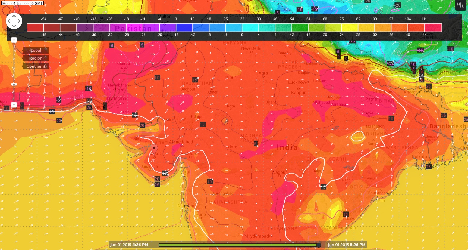
Wunderground Map showing Forecast Temperature at 0900 UTC
(02.30 pm.) on 1st June 2015
Wunderground Map showing Forecast Temperature at 0900 UTC
(02.30 pm.) on 5th June 2015
Monsoon Progress:
During the past 24 hours, winds in the lower tropospheric levels have become more Westerlies/South Westerlies leading to downstream convergence and increase in rainfall over Lakshadweep area and Southern parts of Peninsular India. Persistence of convection indicates that conditions are becoming favorable for onset of Southwest monsoon over Kerala around 5th June.
Weather Forecast In Akila Daily Dated 1st June 2015
Weather Forecast In Sanj Samachar Daily Dated 1st June 2015
Hi Ashok Bhai, I have 2 questions…..can you please explain a bit? : 1) When monsoon days come near in those days we see clouds passing very fast in the sky in the morning…..what may be the reason for that? – Might be more humidity in the morning? but why so fast? 🙂 2) In kerala….I observe that heavy rains take place before monsoon & IMD declares monsoon when there is less amount of rain in kerala & vicinity……why so? & as we know that right now heavy rains lashes in karnataka then also it is not said that monsoon… Read more »

sar dvarka jilama kedi vavni thase
Arbian Sea ma koi System thaay te jovu pade.
Update thashe kai hashe toe
Sir Rajkot aspass 2-3 day ma vavani layak varasad thase? Pl an.
Aagahi vancho.
Namskar Ashokbhai :Atyaray 11:47pm naytrutva khun mathi vadad aavy chy to Su chomasu aagad jadap thi vathi rayhiyou chy aim Mani sakay?
Nichaen a pavan ane vadado ala alag disha ma pan jata hoi. ane bahu ooncha vadado tenathi alag disha ma jata hoi chhe. Kai spast na kahi shakaay.
sir,tame je rite mahiti apo cho tema prashn puchhavano avto j nathi.thodik apdi hosiyari rakhi samajvu mitro.thanx ashok bhai
Sir,vavni layak varsadni shakyata kyare ?
CHomasu Kerala ma bese pachhi 10 thi 15 divas.
sir,aa varshe varsad kevo raheshe ?
Havaman Khata e kahel chhe ke chomasu 93% chhe whole India.
Hu Laambaa gaadaa ni agahi nathi karto.
Sir barometer nu pressure 1000 mb jetalu aaje nichu vayu gayu che to te monsoon mate ni sari sign ganay?
It is because of pressure is low over rajasthan and vicinity.
sir haju 15 thi 20 divas vavani layak varsad ni sakyata khub osi ne ?
Kai ritey chomasu aagad chale chhe te 4/5 divas ma khyal avashe.
Sir ek lowpreser. Bob ma che ane bihu low arabi
yan sea ma che. Ane distubunce anand ma asarkarta rehse
Ekey low pressure nathi BOB ya Arabian ma
Hi Ashok Bhai, I have 2 questions…..can you please explain a bit? : 1) When monsoon days come near in those days we see clouds passing very fast in the sky in the morning…..what may be the reason for that? – Might be more humidity in the morning? but why so fast? 🙂 2) In kerala….I observe that heavy rains take place before monsoon & IMD declares monsoon when there is less amount of rain in kerala & vicinity……why so? & as we know that right now heavy rains lashes in karnataka then also it is not said that monsoon… Read more »
Read this http://www.imd.gov.in/section/nhac/dynamic/mok.pdf
sir incase low preser create thay to sw monson ne effect a thai sake?
It depends on location of Low Pressure and strength of low Pressure.
Sir idar mo aje sauth to north pavan che aenu su karan kayam west thi est hato?
Rajasthan ma UAC chhe etle hoi shake.
sir, does the western disterbence affect the advancment of monsoon,
Most probably it will not affect.