Current Weather Conditions on 25th October 2014 @ 7.30 am.
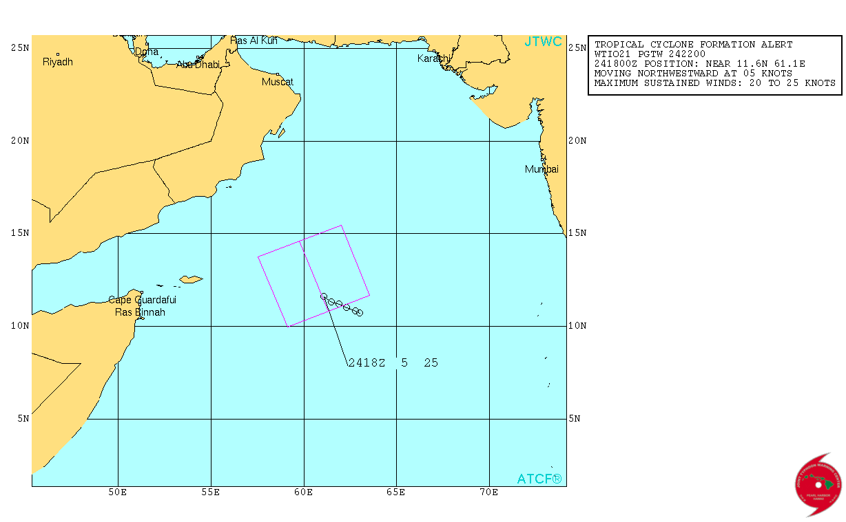
The Well Marked Low Pressure area over West Central Arabian Sea & Adjoining Southwest Arabian Sea has concentrated and reached Depression strength early morning. This has yet to be confirmed by IMD. System is likely to move initially in a North Northwest direction towards Oman and and also expected to further intensify into a Cyclonic Storm.
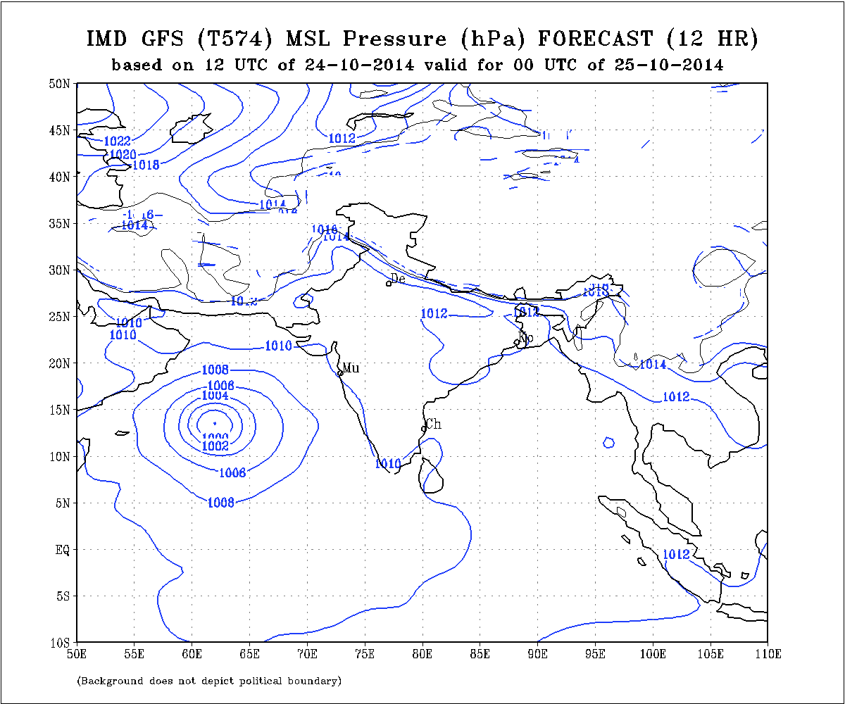
IMD GFS (T574) MSLP Forecast Chart Valid 25th October 2014 @ 00 UTC
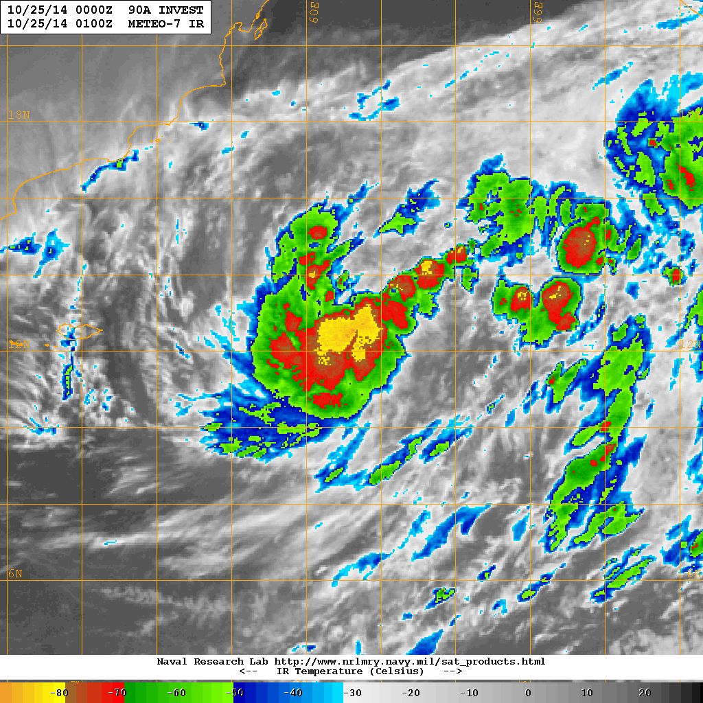
This system is being monitored by NRL as 90A.INVEST. Current location is Lat. 12.0 N & Long. 61.2 E with 30 knots and 1000 mb. in the West Central Arabian Sea & Adjoining Southwest Arabian Sea @ 0000 UTC of 25th October 2014.
JTWC has Issued a Tropical Cyclone Formation Alert
NRL IR Satellite Image Dated 25th Ocotber 2014 @ 0100 UTC
Depression is expected to intensify two notches into a Cyclonic Storm as it tracks initially North Northwestwards towards Oman.
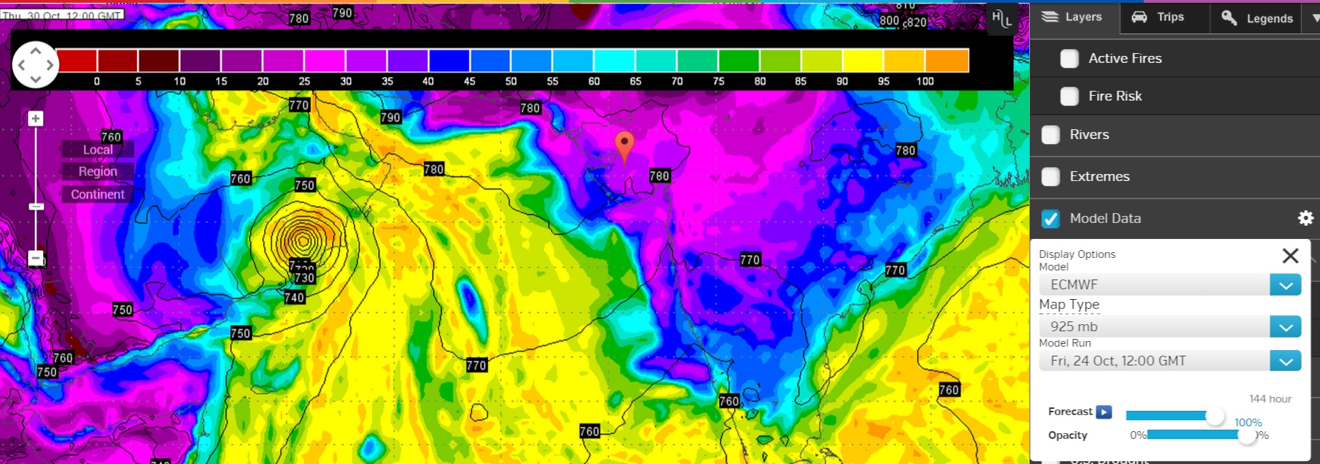
Latest Wunderground ECMWF 925 hPa Forecat Chart Valid 30th October 12 UTC
(based on ECMWF Forecast run dated 24th October 12 UTC)
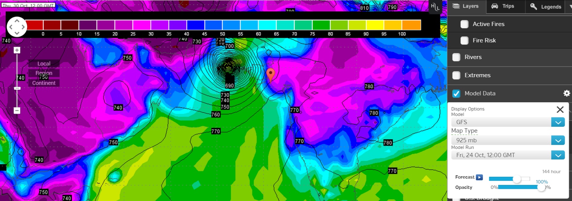
Latest Wunderground GFS 925 hPa Forecat Chart Valid 30th October 12 UTC
(based on GFS Forecast run dated 24th October 12 UTC)
Forecast: 25th to 31st October 2014
ECMWF & GSF are now having different outcome for the System in the West Central Arabian Sea & Adjoining Southwest Arabian Sea. GFS is nearly consistent with the forecast track by subsequently tracking the System Eastwards towards Gujarat/Pakistan, however, the latest ECMWF shows the System tracking towards Oman and making initial Landfall over Oman and weakening considerably by 30th October. Since there is differing outcome from various forecast models, not much confidence is put on the final outcome currently. Since one of the forecast track takes this System towards Gujarat & Saurashtra, farmers should be cautious. Western Disturbance as well as future WD during the forecast period could affect the final outcome this System. Forecast outcome has changed and updates will be given again when some more clarity of track is available.
આગાહી તારીખ ૨૫ થી ૩૧ ઓક્ટોબર ૨૦૧૪:
અરબી સમુદ્ર માં વેલ માર્કડ લો પ્રેસર હતું તે હાલ ડીપ્રેસન ની માત્રા એ પોંચ્યું છે. ૧૨.૦ N. અને ૬૧.૨ E. ઉપર છે. ૩૦ નોટ ના ( ૧ નોટ = ૧.૮૫ કિમી ) પવનો ફૂંકાય છે અને ૧૦૦૦ મિલીબાર પ્રેસર છે. આ સીસ્ટમ હજુ મજબૂત બનશે અને બે દિવસ માં વાવાઝોડામાં પરિવર્તિત થશે. હાલ માં સીસ્ટમ ઊત્તર ઊત્તર પશ્ચિમ તરફ ગતિ કરશે જેથી પહેલા ઓમાન બાજુ જશે. ત્યાર બાદ બંને ફોરકાસ્ટ મોડલ માં મતમતાંતર છે.
એક મોડલ ઓમાન તરફ લઇ જાય છે જયારે બીજું મોડલ તે ઓમાન બાજુથી ૩૦/૩૧ તારીખ આસપાસ પાકિસ્તાન અને ગુજરાત આવે તેવું બતાવે છે. આ સીસ્ટમ પહેલા ઓમાન બાજુ જતી હોઈ સૌરાષ્ટ્ર ગુજરાત તરફ કઈ રીતે આવશે તે જોવાનું છે. હાલ માં આ સીસ્ટમ ની ચાલ કઈ તરફ રહેશે તેમાં ચોક્કસતા નથી લાગતી. હજુ ૨૪ થી ૪૮ કલાક આ સીસ્ટમ નો અભ્યાસ કરી ફોરકાસ્ટ ટ્રેક ની ચોક્કસતા જાણવા મળશે.
ટૂંક માં સૌરાષ્ટ્ર ગુજરાત અને કચ્છ માં સજાગ રહેવું કારણ કે જો ફોરકાસ્ટ મોડલ પ્રમાણે આ સીસ્ટમ સૌરાષ્ટ્ર ગુજરાત અને કચ્છ બાજુ આવે તો પવન અને વરસાદ નું નૂકસાન પણ થઇ શકે. આ સીસ્ટમ ના અનૂસંગિક વાદળ સમૂહો બહુ મોટા વિસ્તાર માં ફેલાશે અને ક્યારેક ક્યારેક તેની પૂછડીયો સૌરાષ્ટ્ર ગુજરાત ઉપર થી પસાર થશે. રવિવાર થી વાદળો નું પ્રમાણ વધશે.
નોંધ: વાવાઝોડા અને આવી સીસ્ટમ માટે હવામાન ખાતા ની માહિતી ઉપર મદાર રાખવો.
00votes
Article Rating
15 Add your comment here
Inline Feedbacks
View all comments
Bhupendra Tejani
25/10/2014 6:33 pm
Sir,
Just now I have seen that Skymet has given news about this depression. The last destination is Karanchi/ Kandla on Dt 29-10-14 viaya Saurashtra.
Umesh lalkiya
25/10/2014 5:35 pm
Sir .. Sistam ne anusangik vadalo thi ak be divas ma sourastra ma varsad ni sakyata che?
Sir,
Since 3 days I ma watching your forecast about Cyclone. But nor any paper nor IMD nor Skymet has confirmed it.
Amit Bhalani
25/10/2014 3:17 pm
Sir cyclone nu su nema aapva ma aavse.ne keyare?
Bhupendra Tejani
25/10/2014 1:46 pm
Sir, I am taking deep interest in your current topic of cyclone from three days. I have not seen news from local papers and from skymet who is forecasting weather report for India, about this cyclone.
As news papers are on mini vacation I have taken picture of current
satellite and your gujarati bulletin and circulate it on Whats app.
અમિત ઠક્કર
25/10/2014 12:50 pm
સર ૨૭ તારીખે આ સિસ્ટમ વાવાઝોડુ બનસે અને તેનુ નામ પાકિસ્તાન દ્વારા આપવામા આવશે “નિલોફર”.પણ સર ખરેખર આ વાવાઝોડા નુ લેન્ડ ફોલ ક્યા થાશે એ હજુ અવઢવ મા છે.વેસ્ટન ડિસ્ટર્બન્સ ને કારણે તે ગુજરાત બાજુ પણ આવી શકે.?
vipin
25/10/2014 12:03 pm
I still feel this will move towards north guj..coz of wind movement from western disturbance effect…
virani naren keshod
25/10/2014 11:57 am
sir gujrat ma vavajodu avse
Rajan Mehta
25/10/2014 11:42 am
sir if this cyclone goes to oman, is there any possibilities that saurashtra will get rain from the effect of this system?
meet patel
25/10/2014 11:40 am
Sir pakku kyare thase ke anand ma varsad padse.ane cyclone ni sakyata khari.
Ramesh Karangia MBA
25/10/2014 10:16 am
Sir kesho ma south direction mathi pavan ave che te cyclone ni asar che
Sir,
Just now I have seen that Skymet has given news about this depression. The last destination is Karanchi/ Kandla on Dt 29-10-14 viaya Saurashtra.
Sir .. Sistam ne anusangik vadalo thi ak be divas ma sourastra ma varsad ni sakyata che?
Yes
Sir etv news na 3p.m nap samachar ma gujrat upar thi cyclone nu sankat tadi gayu.tamaru su kaho cho Sir.?
Maare je kahevanu hoi te update ma apel hoi chhe.
Sir,
Since 3 days I ma watching your forecast about Cyclone. But nor any paper nor IMD nor Skymet has confirmed it.
Sir cyclone nu su nema aapva ma aavse.ne keyare?
Sir, I am taking deep interest in your current topic of cyclone from three days. I have not seen news from local papers and from skymet who is forecasting weather report for India, about this cyclone.
As news papers are on mini vacation I have taken picture of current
satellite and your gujarati bulletin and circulate it on Whats app.
સર ૨૭ તારીખે આ સિસ્ટમ વાવાઝોડુ બનસે અને તેનુ નામ પાકિસ્તાન દ્વારા આપવામા આવશે “નિલોફર”.પણ સર ખરેખર આ વાવાઝોડા નુ લેન્ડ ફોલ ક્યા થાશે એ હજુ અવઢવ મા છે.વેસ્ટન ડિસ્ટર્બન્સ ને કારણે તે ગુજરાત બાજુ પણ આવી શકે.?
I still feel this will move towards north guj..coz of wind movement from western disturbance effect…
sir gujrat ma vavajodu avse
sir if this cyclone goes to oman, is there any possibilities that saurashtra will get rain from the effect of this system?
Sir pakku kyare thase ke anand ma varsad padse.ane cyclone ni sakyata khari.
Sir kesho ma south direction mathi pavan ave che te cyclone ni asar che
so dubai ma rain na chance che ?