Updated @ 2.00 pm.
Current Weather Conditions on 2nd August 2014 @ 2.00 am.
The shortfall in cumulative rainfall over Saurashtra & Kutch as well as Gujarat region has drastically reduced from 90% to now just 18% shortfall for Saurashtra & Kutch while shortfall over Gujarat has reduced to just 23%. Whole India shortfall till 1st August has gone down to 21%.
IMD Map Showing Cumulative Rainfall Performance Till 1st August 2014
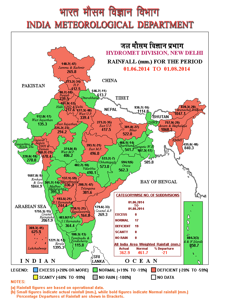
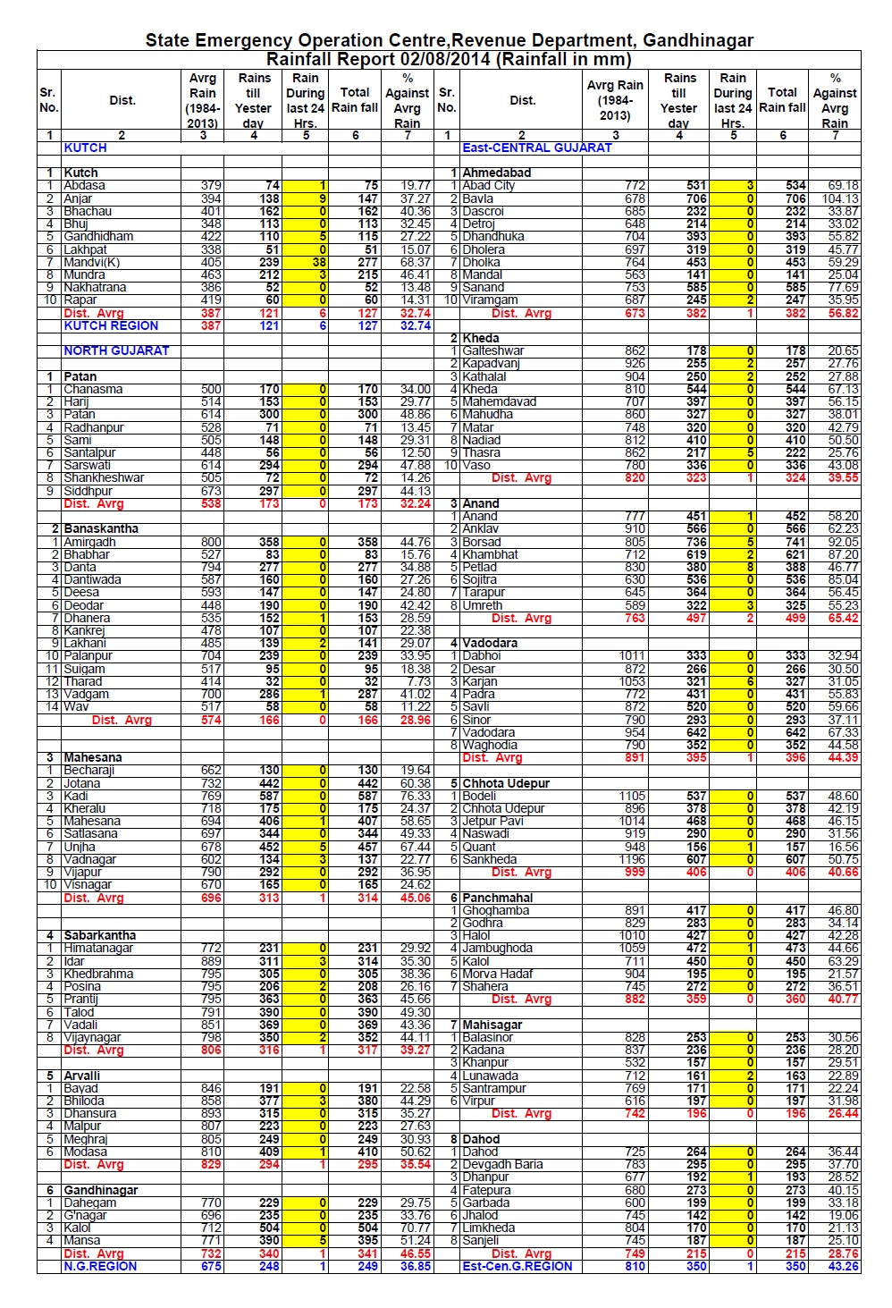
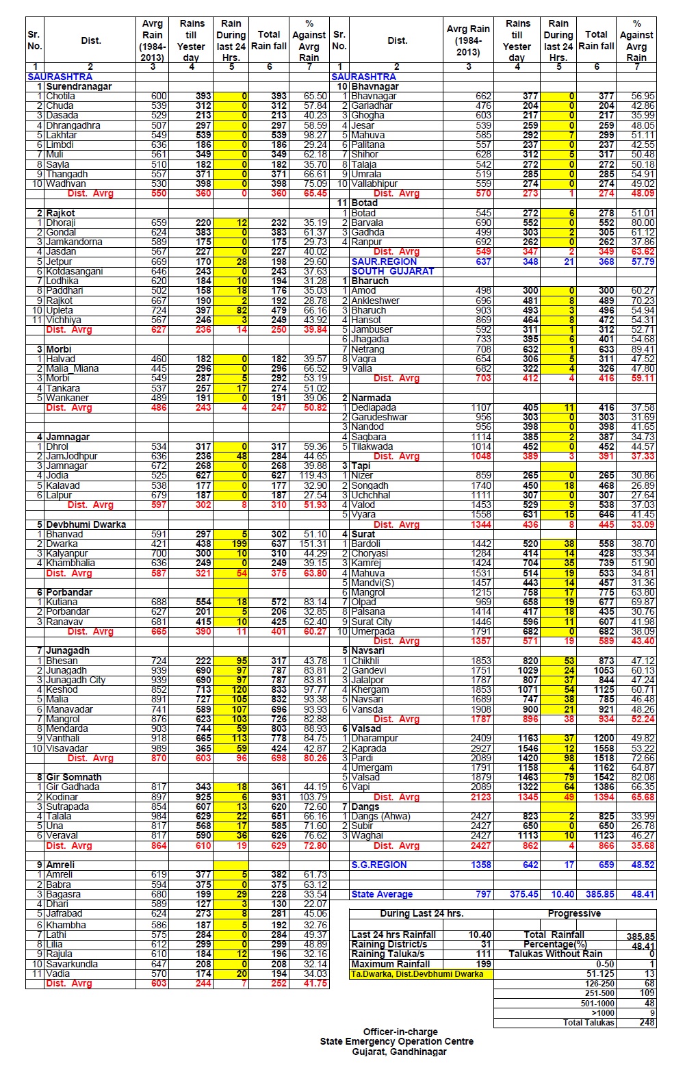
There has been exceptionally good rainfall over most parts of Gujarat, Saurashtra & Kutch. The latest rainfall figures for whole Gujarat are given below:

Conditions based on 2nd August @ 09.30 am. IST
The Southwest Monsoon has been vigorous over Saurashtra & Kutch and
Kerala and active over Nagaland-Manipur-Mizoram-Tripura and coastal
Karnataka. It has been subdued over Arunachal Pradesh, west Uttar
Pradesh, Marathwada, Vidarbha, Telangana and Rayalaseema.
The axis of monsoon trough at mean sea level now passes through
Ganganagar, Narnaul, Agra, Varanasi, Gaya, Bankura, Digha and thence
Southeastwards to East Central Bay of Bengal. It extends upto 3.1 kms above sea level
passing across the same region.
The offshore trough at mean sea level from south Gujarat coast to Kerala coast
persists.
The Cyclonic Circulation over Northwest Bay of Bengal and neighborhood
persists and extends between 2.1 and 7.6 kms above sea level. Under its influence a Low
Pressure area would form over the same region on 3rd/4th August.
The Cyclonic Circulation over East Madhya Pradesh and neighborhood now lies
over Northeast Madhya Pradesh and adjoining Southeast Uttar Pradesh and
extends upto 1.5 kms above sea level.
The Cyclonic Circulation extending up to 3.1 km above sea level is now located over Saurashtra/Kutch and adjoining Arabian Sea.
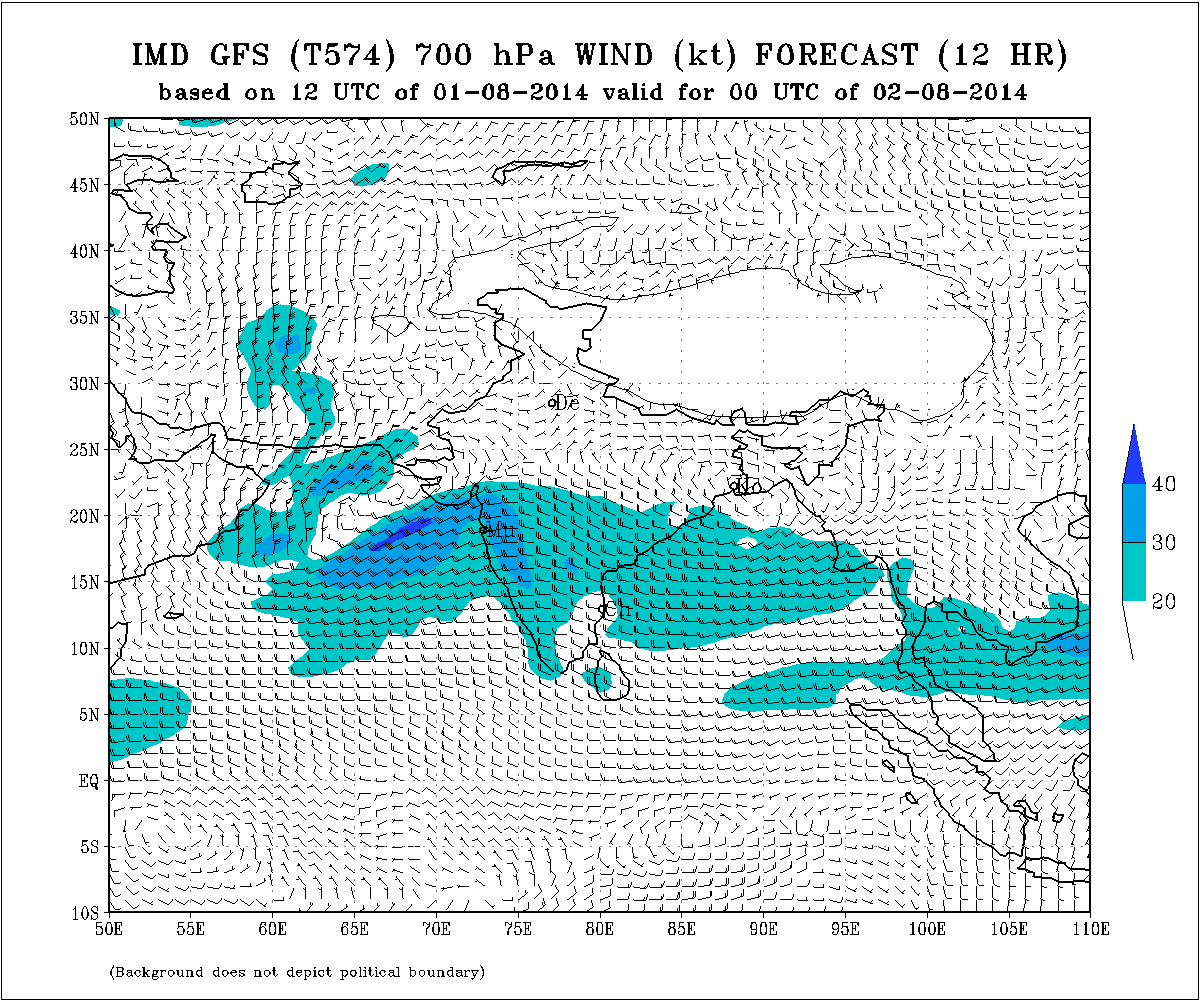
IMD Weather Chart of 700 hPa Valid for 00 UTC 2nd August 2014
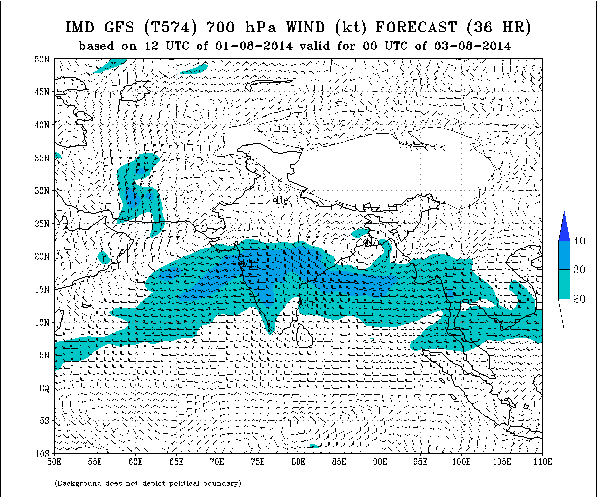
IMD Weather Chart of 700 hPa Valid for 00 UTC 3rd August 2014
Forecast: 2nd August to 5th August 2014
Saurashtra, Kutch & Gujarat:
The current round of Rainfall will end on 2nd August.
Rainfall amount as well as area coverage will reduce from 3rd August to 5th August. There will be scattered showers/rainfall during the period 3rd to 5th August.
A Low Pressure is expected to develop around 3rd/4th August in the Bay of Bengal.
આગાહી: સૌરાષ્ટ્ર, કચ્છ અને ગુજરાત
આજનો દિવસ આ વરસાદ નો રાઉન્ડ છે. આવતી કાલ ૩થી ૫ તારીખ સુધી છુટા છવાયા ઝાપટા અને હળવો માધ્યમ વરસાદ. પરંતુ વિસ્તાર ઓછો હશે. દક્ષીણ ગુજરાત માં મધ્યમ વરસાદ ચાલુ રહેશે.
બંગાળની ખાડી માં હજુ લો પ્રેસર નથી થયું. તારીખ ૩થી ૪ ઓગસ્ટ વચ્ચે લો પ્રેસર થશે.
Junagadh ma kale 1 kalak saro avo varsad padiyo
Amreli jilla na kyarthi varasad che ane ketalo che te janavaso ashok bhai
Ek ek area pramane vigat ahi thi aapi na skakaay.
Sir rajkot jila ma tamaro anuman su ke che varsad ma
Prashna ek var poonchho ane jawaab ni raah jovo.
Haal zaapta shivaay koi moto varsad nathi.
સર બંગાળની ખાડીનું લો પ્રેહ્સ્રની ગતિ કઈ તરફ છે અને સૌરાષ્ટ્ર ને ફાયદો થશે તે જણાવવા વિનતી
તમે વાંચો છો તે સિવાય બીજી અપડેટ છે તે વાંચો.
નવી અપડેટ મુકેલ છે.