21st June 2022
ગુજરાત રાજ્ય ના 87 તાલુકા માં છેલ્લા 24 કલાક દરમિયાન વરસાદ, જે માંથી 33 તાલુકામાં 10 mm અથવા વધુ થયેલ.
24 Hours Descending Rainfall in Gujarat State (Data: SEOC, Gandhinagar) 87 Talukas of State received rainfall. 33 Talukas received 10 mm or more rainfall.

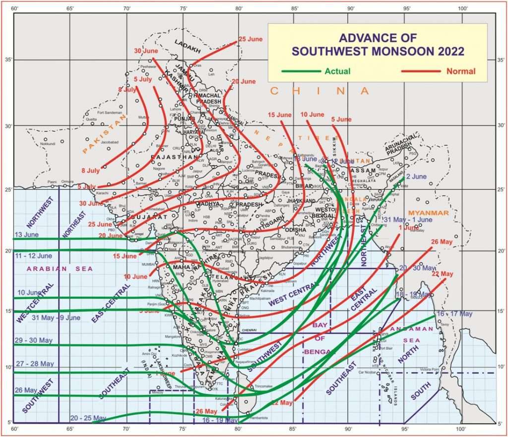
Southwest Monsoon Has Entered North Arabian Sea, South Coastal Saurashtra, Diu, Parts Of South Gujarat Today, The 13th June, 2022
દક્ષિણ પશ્ચિમ ચોમાસુ નોર્થ અરબી સમુદ્ર માં દાખલ થયું, દક્ષિણ સૌરાષ્ટ્ર નો દરિયા કિનારો, દીવ અને દક્ષિણ ગુજરાત ના અમુક ભાગો માં પહોંચ્યું આજે 13 જૂન 2022
Source IMD
Advancement of Southwest Monsoon:
Southwest Monsoon has further advanced into some more parts of Arabian Sea, some parts of Gujarat state, entire Konkan, most parts of Madhya Maharashtra, most parts of Marathwada and Karnataka, Some parts of Telangana and Rayalaseema, some more parts of Tamil Nadu, most parts of Sub-Himalayan West Bengal, some parts of Bihar today, the 13th June, 2022.
The Northern Limit of Monsoon (NLM) now passes through Lat. 21°N/ Long. 60°E, Lat. 21°N/ Long. 70°E, Diu, Nandurbar, Jalgaon, Parbhani, Bidar, Tirupati, Puducherry, Lat. 14°N/ Long. 84°E, Lat. 17.0°N/ Long. 87°E, Lat.20.0°N/89.5°E, Lat.22.0°N/90°E, Lat.25.0°N/89°E, Balurghat and Supaul, 26.50°N/86°E.
Conditions are favorable for further advance of monsoon into some more parts of north Arabian sea, some more parts of Gujarat state, some parts of south Madhya Pradesh, entire Madhya Maharashtra, Marathwada, Karnataka and Tamil Nadu, some parts Vidarbha and Telengana, some more parts of Andhra Pradesh, Westcentral & northwest Bay of Bengal during next 48 hours.
Conditions would continue to become favorable for further advance of monsoon into some more parts of Telengana, Andhra Pradesh, Bay of Bengal, some parts of Odisha, Gangetic West Bengal, Jharakhand, entire Sub-Himalayan West Bengal and some more parts of Bihar during subsequent 2 days.
The off-shore trough at mean sea level from south Gujarat coast to north Kerala coast persists.
A cyclonic circulation lies over East Central Arabian Sea between 3.1 km & 7.6 km above mean sea level tilting southwestwards with height.
A trough runs from above cyclonic circulation over East Central Arabian sea to Northeast Madhya Pradesh across Maharashtra between 3.1 km & 4.5 km above mean sea level. The trough from north Madhya Maharashtra to central parts of Arabian Sea has merged with the above trough.
Current weather Conditions:
Pre-monsoon activity expected over parts of Saurashtra, Kutch & Gujarat. Monsoon has set in over South Coastal Saurashtra, Diu, parts of South Gujarat.
Forecast: Saurashtra, Gujarat & Kutch: 13th to 17th June 2022
Winds will be mainly from Southwest and on few days during evening times winds will be variable during the forecast period. Wind speed of 20 to 35 kms/hour during the forecast period.
Maximum Temperature expected to be near normal and even below normal where rainfall has occurred. Humidity is expected to remain high on some days.
Possibility of Monsoon onset over more parts of Saurashtra and Gujarat during the forecast period. Possibility of scattered pre-monsoon activity for areas that are not covered by monsoon including Kutch during the forecast period.
ચોમાસા ની ગતિવિધિ:
તારીખ 17 જૂન સુધી નું તારણ : નોર્થ અરબી ના થોડા વધુ ભાગો, ગુજરાત રાજ્ય ના ભાગો તેમજ સમગ્ર કર્ણાટક, તામિલનાડુ, મહારાષ્ટ્ર, તેમજ તેલંગાણા, આંધ્ર ના ભાગો માં ચોમાસુ આગળ વધશે. મધ્ય પશ્ચિમ અને ઉત્તર પશ્ચિમ બંગાળની ખાડી માં ચોમાસુ આગળ ચાલશે તેમજ ઓડિશા, પશ્ચિમ બંગાળ, બિહાર અને ઝારખંડ માં પણ ચોમાસુ દાખલ થશે.
પરિસ્થિતિ:
સી લેવલ પર એક ઓફ શોર ટ્રફ દક્ષિણ ગુજરાત થી નોર્થ કેરળ સુધી છવાયેલ છે.
એક યુએસી મધ્ય પૂર્વ અરબી સમુદ્ર પર 3.1 કિમિ થી 7.6 કિમિ ની ઉંચાઈ સુધી છે જે વધતી ઉંચાઈએ દક્ષિણ પશ્ચિમ તરફ ઝુકે છે.
મધ્ય પૂર્વ અરબી સમુદ્ર ના ઉપરોક્ત યુએસી થી મહારાષ્ટ્ર થઇ ને નોર્થ એમપી સુધી એક ટ્રફ લંબાય છે.
આગાહી સૌરાષ્ટ્ર, ગુજરાત અને કચ્છ 13 થી 17 જૂન 2022
આગાહી સમય માં પવન મુખ્યત્વે દક્ષિણ પશ્ચિમ અને સાંજ ના સમયે અમુક દિવસે પવન ફરતો રહેશે. પવન ની ગતિ 20-35 કિમિ/કલાકે ના રહેશે. આખા દિવસ માં સૌથી વધુ પવન સાંજે જોવા મળશે.
સૌરાષ્ટ્ર, ગુજરાત અને કચ્છ માં મહત્તમ તાપમાન નોર્મલ નજીક રહેશે. વરસાદ વાળા સેન્ટરો માં મહત્તમ તાપમાન નોર્મલ થી નીચું પણ જોવા મળે. ભેજ અમુક દિવસે વધુ જોવા મળે.
આગાહી સમય માં નોર્થ અરબી સમુદ્ર ના થોડા વધુ ભાગો માં, સૌરાષ્ટ્ર ના ભાગો માં તેમજ ગુજરાત ના થોડા વધુ ભાગો માં ચોમાસુ બેસે તેવા સંજોગ છે. ગુજરાત રાજ્ય ના જે વિસ્તાર માં ચોમાસુ ના બેઠું હોય ત્યાં પ્રિ-મોન્સૂન એક્ટિવિટી જોવા મળશે.
.
Caution: Please refer/rely on IMD/RSMC Bulletins/Advisories for Storms & Weather related matter.
સાવચેતી: સ્ટોર્મ કે હવામાન અંગે ની માહિતી માટે ભારતીય હવામાન ખાતા/ગવર્મેન્ટ ના બુલેટીન/સુચના પર નિર્ભર રહેવું.
Read Comment Policy – કમેન્ટ માટે માર્ગદર્શન વાંચો
How To Upload Profile Picture For WordPress – વર્ડપ્રેસ માં પ્રોફાઈલ પિક્ચર કેમ રાખવું
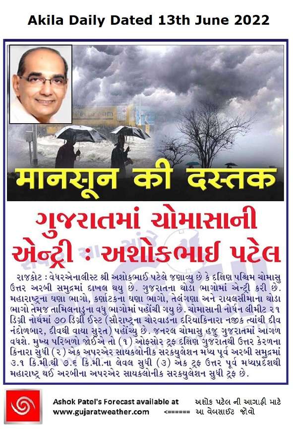
Forecast In Akila Daily Dated 13th June 2022
Forecast In Sanj Samachar Daily Dated 13th June 2022