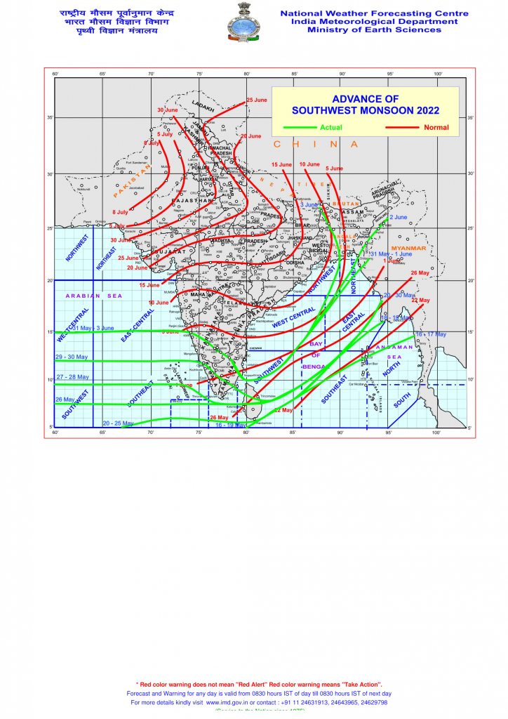
Southwest Monsoon Has Advanced Into Some More Parts Of North & Central Bay of Bengal, Entire Northeastern States And Some Parts Of Sub Himalayan West Bengal & Sikkim, Today, The 3rd June 2022
દક્ષિણ પશ્ચિમ ચોમાસુ ઉત્તર અને મધ્ય બંગાળ ની ખાડી ના થોડા વધુ ભાગો, સમગ્ર પૂર્વોત્તર રાજ્યો, અને પર્વતીય પશ્ચિમ બંગાળ અને સિક્કિમ ના ભાગો માં આગળ ચાલ્યુ 3 જૂન 2022
The Northern Limit of Monsoon (NLM) now passes through Lat. 15°N/ Long. 60°E, Lat. 15°N/ Long. 70°E, Karwar, Chikmagaluru, Bengaluru, Dharmapuri, Lat. 10°N/ Long. 80°E, Lat. 11.0°N/ Long. 83°E, Lat.14.0°N/Long.86°E, Lat.22.0°N/90°E, Lat.25.0°N/89°E, Siliguri and 27.50°N/88°E.
IMD 2 Weeks Extended Forecast:
extended_020622
Current Weather Conditions on 3rd June 2022
Gujarat Observations:
Above normal Temperature prevails from last two day over Saurashtra, Gujarat & Kutch. The Maximum Temperatures are currently 2 C above normal. Maximum Temperature range is 41.5C to 43 C.
Maximum Temperature on 2nd June 2022 was as under:
Ahmedabad 43.2 C which is 2 C above normal
Rajkot 41.5 C which is 2 C above normal
Amreli 42.2 C which is 3 C above normal
Deesa 41.6 C which is normal
Bhuj 40.2 C which is 2 C above normal
Forecast: Saurashtra, Gujarat & Kutch: 3rd to 10th June 2022
Winds will be mainly variable from Southwest, West & Northwest till 5th June and subsequently winds will be mainly from Southwest direction during the rest of the forecast period. Wind speed of 20 to 35 kms/hour during the forecast period
Maximum Temperature expected to be above normal till 6th June and subsequently near normal during rest of the forecast period. Afternoon/Evening Humidity expected to incrementally increase from 5th June. Coastal areas to have higher humidity. Due to increase in evening humidity the real feal Temperature will be high.
Atmospheric instability will increase from 6th June. Scattered high clouds expected on some days before 8th June. Low level clouds expected from 8th on wards. Possibility of scattered pre-monsoon activity on a day or two during the forecast period.
પરિસ્થિતિ:
સૌરાષ્ટ્ર ગુજરાત અને કચ્છ માં બે દિવસ થયા ગરમી નોર્મલ થી 2 C વધુ છે, તાપમાન 41.5C થી 43.0 C રેન્જ માં છે.
આગાહી સૌરાષ્ટ્ર, ગુજરાત અને કચ્છ 3 થી 10 જૂન 2022
આગાહી સમય માં પવન ફરતો જેમાં મુખ્યત્વે દક્ષિણ પશ્ચિમ, પશ્ચિમ, અને ઉત્તર પશ્ચિમ ના તારીખ 5 સુધી. આગાહી સમય ના બાકી ના સમય માટે પવન મુખ્યત્વે દક્ષિણ પશ્ચિમ ના રહેશે. પવન ની ગતિ 20-35 કિમિ/કલાકે ના રહેશે. આખા દિવસ માં સૌથી વધુ પવન સાંજે જોવા મળશે.
સૌરાષ્ટ્ર, ગુજરાત અને કચ્છ માં મહત્તમ તાપમાન 6 તારીખ સુધી નોર્મલ થી ઉંચુ રહેશે અને ત્યાર બાદ નોર્મલ નજીક રહેશે. તારીખ 5 જૂન થી ક્રમશ બપોર/સાંજ ના ભેજ વઘશે એટલે બફારા નો અહેસાસ થશે. દરિયા પટ્ટી માં ભેજ નું પ્રમાણ વધુ જોવા મળશે.
તારીખ 6 જૂન થી અસ્થિરતા વધશે. 7 તારીખ સુધી કોઈ કોઈ દિવસ છુટા છવાયા ઉંચા વાદળ અને ત્યાર બાદ ના સમય માં નીચા લેવલ ના છુટા છવાયા વાદળ અમુક દિવસ જોવા મળશે. આગાહી સમય ના એકાદ બે દિવસ ક્યાંક ક્યાંક પ્રિમોન્સૂન એક્ટિવિટી થઇ શકે.
.
Caution: Please refer/rely on IMD/RSMC Bulletins/Advisories for Storms & Weather related matter.
સાવચેતી: સ્ટોર્મ કે હવામાન અંગે ની માહિતી માટે ભારતીય હવામાન ખાતા/ગવર્મેન્ટ ના બુલેટીન/સુચના પર નિર્ભર રહેવું.
Read Comment Policy – કમેન્ટ માટે માર્ગદર્શન વાંચો
How To Upload Profile Picture For WordPress – વર્ડપ્રેસ માં પ્રોફાઈલ પિક્ચર કેમ રાખવું