Relief From Hot Weather Expected Over Saurashtra, Gujarat & Kutch – Maximum Temperatures Likely to Range Between 40°C and 43°C During 15th to 21st May 2026
સૌરાષ્ટ્ર, ગુજરાત અને કચ્છમાં ગરમીમાં રાહતની શક્યતા -15 મેથી 21 મે 2026 દરમિયાન મહત્તમ તાપમાન 40°C થી 43°C વચ્ચે રહેવાની સંભાવના
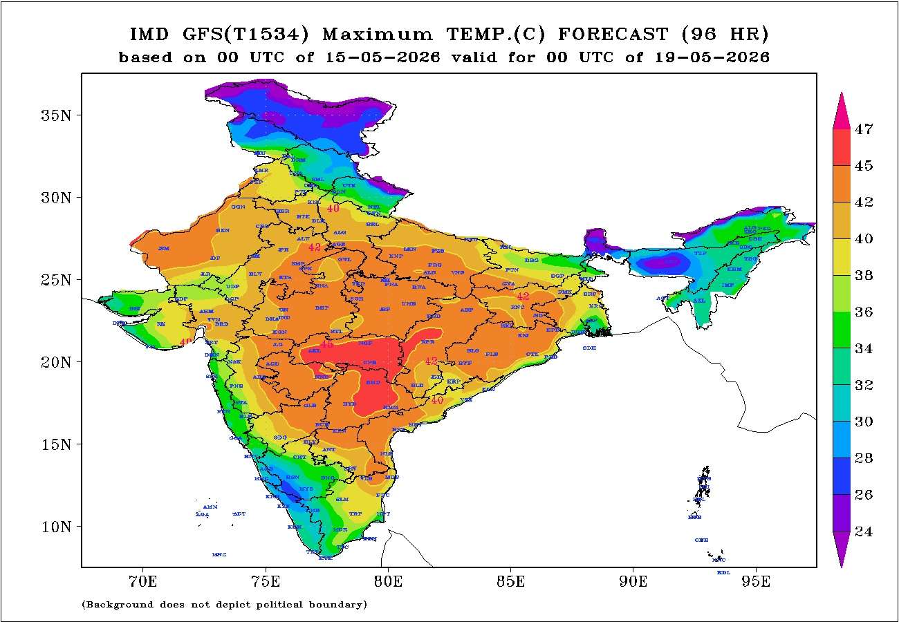
Gujarat Temperature Observations (14th May 2026)
Maximum temperatures on 14th May 2026 were around 2°C to 3°C above normal across most of the hot centers of Gujarat State.
- Rajkot: 43.1°C (2.3°C above normal)
- Deesa: 42.4°C (2.0°C above normal)
- Amreli: 42.9°C (2.1°C above normal)
- Ahmedabad: 43.7°C (2.1°C above normal)
- Vadodara: 43.2°C (3.1°C above normal)
- Bhuj: 40.6°C (1.5°C above normal)
Current Normal Maximum Temperature across most of Gujarat: 40.5°C to 41.5°C
Weather Forecast for Saurashtra, Gujarat & Kutch 15th to 21st May 2026
Wind Pattern
- Winds will predominantly remain Westerly.
- Wind Speed: 15–20 km/h up to 18th May, increasing to 20–30 km/h thereafter.
- Wind Gusts: 20–25 km/h up to 18th May, increasing to 25–35 km/h thereafter.
Sky Conditions
- Partly cloudy conditions are expected for the next two days.
- Skies will remain mostly clear on the remaining days.
Temperature Outlook
Maximum temperatures are expected to decrease by around 2°C to 3°C from recent levels, bringing noticeable relief from the recent hot weather.
- Most hot centers across Gujarat are likely to record maximum temperatures in the range of 40°C to 43°C on most days during the forecast period.
- Day-to-day fluctuations of 1°C to 3°C are likely.
- Most locations are expected to remain in the 40°C to 42°C range, while a few centers may occasionally reach the upper end of the forecast range near 43°C.
Summary
Relief from the recent hot weather is expected over Saurashtra, Gujarat, and Kutch during the next seven days.
Maximum temperatures are likely to remain mostly in the range of 40°C to 43°C, which is closer to seasonal normal levels and lower than the temperatures experienced during the past several days.
Relief From Hot Weather Expected Over Saurashtra, Gujarat & Kutch – Maximum Temperatures Likely to Range Between 40°C and 43°C During 15th to 21st May 2026
સૌરાષ્ટ્ર, ગુજરાત અને કચ્છમાં ગરમીમાં રાહતની શક્યતા -15 મેથી 21 મે 2026 દરમિયાન મહત્તમ તાપમાન 40°C થી 43°C વચ્ચે રહેવાની સંભાવના
ગુજરાતના તાપમાન અવલોકન (14 મે 2026)
14 મે 2026ના રોજ ગુજરાત રાજ્યના મોટા ભાગના ગરમ કેન્દ્રોમાં મહત્તમ તાપમાન નોર્મલ કરતાં આશરે 2°C થી 3°C વધુ નોંધાયું હતું.
- રાજકોટ: 43.1°C (નોર્મલ કરતાં 2.3°C વધુ)
- ડીસા: 42.4°C (નોર્મલ કરતાં 2.0°C વધુ)
- અમરેલી: 42.9°C (નોર્મલ કરતાં 2.1°C વધુ)
- અમદાવાદ: 43.7°C (નોર્મલ કરતાં 2.1°C વધુ)
- વડોદરા: 43.2°C (નોર્મલ કરતાં 3.1°C વધુ)
- ભુજ: 40.6°C (નોર્મલ કરતાં 1.5°C વધુ)
ગુજરાતના મોટા ભાગના વિસ્તારોમાં હાલનું નોર્મલ મહત્તમ તાપમાન: 40.5°C થી 41.5°C ગણાય.
સૌરાષ્ટ્ર, ગુજરાત અને કચ્છ માટે હવામાન આગાહી 15 મેથી 21 મે 2026
પવનની સ્થિતિ
- પવનો મુખ્યત્વે પશ્ચિમી દિશાના રહેશે.
- પવનની ઝડપ: 18 મે સુધી 15 થી 20 કિમી પ્રતિ કલાક, ત્યારબાદ 20 થી 30 કિમી પ્રતિ કલાક.
- પવનના ઝોકા: 18 મે સુધી 20 થી 25 કિમી પ્રતિ કલાક, ત્યારબાદ 25 થી 35 કિમી પ્રતિ કલાક.
આકાશની સ્થિતિ
- આગામી બે દિવસ દરમિયાન આકાશ આંશિક વાદળછાયું રહેવાની શક્યતા છે.
- ત્યારબાદના દિવસોમાં આકાશ મોટાભાગે ચોખ્ખું રહેશે.
તાપમાનનો અંદાજ
તાજેતરના સ્તર કરતાં મહત્તમ તાપમાનમાં આશરે 2°C થી 3°C ઘટાડો થવાની શક્યતા છે, જેના કારણે ગરમીમાં નોંધપાત્ર રાહત મળશે.
- ગુજરાતના મોટા ભાગના ગરમ કેન્દ્રોમાં આગાહી સમયગાળા દરમિયાન મોટાભાગના દિવસોમાં મહત્તમ તાપમાન 40°C થી 43°C વચ્ચે નોંધાવાની શક્યતા છે.
- દૈનિક ધોરણે 1°C થી 3°C જેટલી વધઘટ શક્ય છે.
- મોટા ભાગના વિસ્તારોમાં મહત્તમ તાપમાન 40°C થી 42°C વચ્ચે રહેશે, જ્યારે થોડાક કેન્દ્રોમાં ક્યારેક 43°C સુધી પહોંચી શકે છે.
સારાંશ
આગામી સાત દિવસ દરમિયાન સૌરાષ્ટ્ર, ગુજરાત અને કચ્છમાં ગરમીમાં રાહત મળવાની શક્યતા છે.
મહત્તમ તાપમાન મોટાભાગે 40°C થી 43°C વચ્ચે રહેવાની સંભાવના છે, જે મોસમી નોર્મલની નજીક રહેશે અને છેલ્લા કેટલાક દિવસોમાં અનુભવાયેલી વધુ ગરમીની તુલનામાં ઓછું રહેશે.
Caution: Please refer/rely on IMD/RSMC Bulletins/Advisories for Storms & Weather related matter.
સાવચેતી: સ્ટોર્મ કે હવામાન અંગે ની માહિતી માટે ભારતીય હવામાન ખાતા/ગવર્મેન્ટ ના બુલેટીન/સુચના પર નિર્ભર રહેવું.
Read Comment Policy – કમેન્ટ માટે માર્ગદર્શન વાંચો
How To Upload Profile Picture For WordPress – વર્ડપ્રેસ માં પ્રોફાઈલ પિક્ચર કેમ રાખવું
Forecast In Akila Daily Dated 15th May 2026
Forecast In Sanj Samachar Daily Dated 15th May 2026