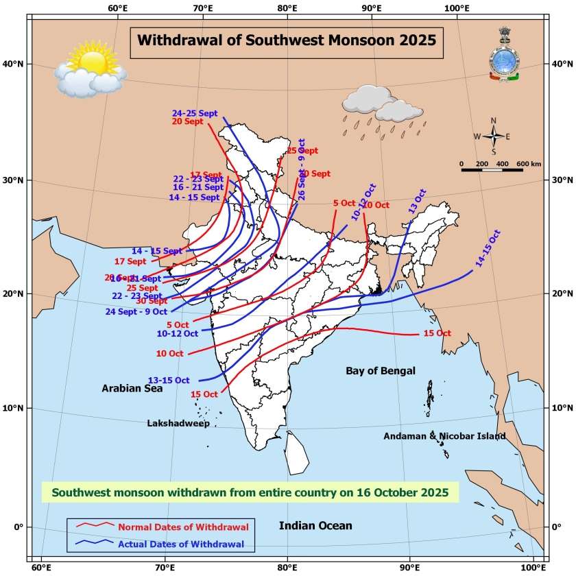
On 16th October 2025, The Southwest Monsoon Withdraws From The Entire Country: Northeast Monsoon Sets In Over South India
16 ઓક્ટોબર 2025 ના રોજ, સમગ્ર દેશમાં થી દક્ષિણ પશ્ચિમ ચોમાસુ વિદાય થયું : સાથે દક્ષિણ ભારત પર નોર્થઇસ્ટ ચોમાસુ બેઠું
Current Weather Conditions on 16th October 2025
From IMD Bulletin:
Southwest monsoon has withdrawn from the entire country today, the 16th October 2025. Simultaneously, the Northeast Monsoon rainfall activity has commenced over Tamil Nadu, Puducherry & Karaikal, Coastal Andhra Pradesh, Rayalaseema, South Interior Karnataka and Kerala-Mahe today, the 16th October, in association with following features:
(a) An upper air cyclonic circulation lies over Comorin area & neighborhood extending up to mid tropospheric levels.
(b) Easterly / northeasterly winds set-in over southern peninsular India, south & adjoining central Bay of Bengal in the lower tropospheric levels,.
(c) Fairly widespread rainfall occurred over Tamil Nadu, Puducherry & Karaikal and adjoining area of south coastal Andhra Pradesh and Kerala during the past 24 hrs. Rainfall also occurred at a few places over Rayalaseema and adjoining areas of South Interior Karnataka during the same period.
(d) Isolated heavy to very heavy rainfall occurred over Tamilnadu during the same period.
The upper air cyclonic circulation over south Bihar & neighborhood now lies over north Jharkhand and neighborhood at 3.1 km above mean sea level.
The upper air cyclonic circulation over southeast Arabian Sea & adjoining Lakshadweep area persists over the same region extending up to 5.8 km above mean sea level tilting southward with height. Under its influence, a low pressure area is likely to form over southeast Arabian Sea & Lakshadweep area off Kerala-Karnataka coasts around 18th October, 2025. Thereafter, it is likely to move west north-westwards and intensify into a depression during subsequent 48 hours.
Forecast: Saurashtra, Gujarat & Kutch 16th to 22nd October 2025
The weather will remain mostly dry with sunshine and the Temperature will be near normal at around 35C to 36 C over most places.
The Potential Low Pressure or a Depression System expected to form after few days. The distance of that System will be more than 900 to 1000 kms from Gujarat Coast and will be monitored. Current estimate is that there would not be any significant effect of unseasonal rainfall over Gujarat State. Update will be given as and when the System Develops.
16 ઓક્ટોબર 2025 ના રોજ, સમગ્ર દેશમાં થી દક્ષિણ પશ્ચિમ ચોમાસુ વિદાય થયું : સાથે દક્ષિણ ભારત પર નોર્થઇસ્ટ ચોમાસુ બેઠું
હાલ ની સ્થિતિ
IMD બુલેટિન અનુસાર:
આજ, 16th October 2025ના રોજ, દક્ષિણ પશ્ચિમ ચોમાસુ સમગ્ર દેશમાં વિદાય થઇ ગઈ છે. તે જ સમયે, નોર્થઇસ્ટ ચોમાસુ પ્રવૃત્તિ તામિલનાડુ પુડ્ડુચેરી કોસ્ટલ આંધ્ર પ્રદેશ, રાયસીમાં દક્ષિણ અંદરૂની કર્ણાટક કેરળ માંહે માં શરૂ થઈ ગઈ છે, જે નીચેના લક્ષણો સાથે સંકળાયેલી છે:
(a) યુએસી કોમોરીન વિસ્તાર અને આજુબાજુમાં રહેલા વિસ્તારોમાં, મીડ ટ્રોપોસ્ફિયર લેવલમાં.
(b) પૂર્વોત્તર પવનો દક્ષિણ પેનિનસુલાર ઈન્ડિયા, દક્ષિણ અને જોડાયેલ મિડલ બેય ઓફ બંગાળમાં નીચલા લેવલ માં શરૂ થઈ ગયા છે.
(c) છેલ્લા 24 કલાકમાં તામિલનાડુ પુડ્ડુચેરી કરાયલકલ અને દક્ષિણ કોસ્ટલ આંધ્ર પ્રદેશ અને કેરળ ના જોડાયેલા વિસ્તારોમાં ઘણો વરસાદ થયો છે. એ જ સમયગાળા દરમિયાન રાયલસીમા અને દક્ષિણ અંદરૂની કર્ણાટક ના જોડાયેલા વિસ્તારોમાં પણ કેટલાક સ્થળોએ વરસાદ નોંધાયો છે.
(d) એ જ સમયગાળા દરમિયાન તામિલનાડુ માં અલગ-અલગ જગ્યાએ ભારે થી ખૂબ ભારે વરસાદ થયો છે.
દક્ષિણ બિહાર અને આજુબાજુના વિસ્તારોમાં યુએસી હવે નોર્થ ઝારખંડ અને આજુબાજુના વિસ્તારોમાં 3.1 કિમિ ના લેવલ પર આવેલું છે.
દક્ષિણ પૂર્વ અરબી સમુદ્ર અને જોડાયેલ લક્ષદ્વિપ વિસ્તારમાં યુએસી હજુ પણ તે જ વિસ્તારમાં જ છે, 5.8 કિમિ ઉંચાઈએ સી લેવલ થી છે અને ઊંચાઈ સાથે દક્ષિણ તરફ ઝુકે છે. તેના પ્રભાવ હેઠળ, 18th October 2025ના આસપાસ કેરળ કર્ણાટક ના કિનારા નજીક દક્ષિણ પૂર્વ અરબી સમુદ્ર અને લક્ષદ્વિપ વિસ્તાર માં લો પ્રેસર બનવાની સંભાવના છે. ત્યાર બાદ, તે પશ્ચિમ-ઉત્તર પશ્ચિમ તરફ જવા અને આગામી 48 કલાકમાં ડિપ્રેશન માં તીવ્ર થવાની શક્યતા છે.
આગાહી: સૌરાષ્ટ્ર, કચ્છ અને ગુજરાત 16 થી 22 ઓક્ટોબર 2025
હવામાન મોટાભાગે સુકું રહેશે અને તડકો પણ રહેશે, અને તાપમાન મોટાભાગના સ્થળોએ 35°C થી 36°C ની આસપાસ નોર્મલ નજીક રહેશે.
થોડા દિવસો પછી દક્ષિણ પૂર્વ અરબી સમુદ્ર પર એક લો પ્રેસર થવાની અને મજબૂત થવાની શક્યતા છે. તે સિસ્ટમ ગુજરાત કિનારે થી લગભગ 900 થી 1000 કિ.મી. દૂર હશે અને તેનું અવલોકન કરવામાં આવશે. હાલમાં અંદાજ મુજબ, ગુજરાત રાજ્યમાં ખાસ અસર કરે એવું નથી. સિસ્ટમ વિકસિત થાય ત્યારે અપડેટ આપવામાં આવશે.
Caution: Please refer/rely on IMD/RSMC Bulletins/Advisories for Storms & Weather related matter.
સાવચેતી: સ્ટોર્મ કે હવામાન અંગે ની માહિતી માટે ભારતીય હવામાન ખાતા/ગવર્મેન્ટ ના બુલેટીન/સુચના પર નિર્ભર રહેવું.
Read Comment Policy – કમેન્ટ માટે માર્ગદર્શન વાંચો
How To Upload Profile Picture For WordPress – વર્ડપ્રેસ માં પ્રોફાઈલ પિક્ચર કેમ રાખવું