Bay System Expected To Give Beneficial Round of Rainfall For Gujarat State: 4th–9th September 2025
બંગાળ ની ખાડી ની સિસ્ટમ ગુજરાત રાજ્યમાં ફાયદારૂપ વરસાદી રાઉન્ડ આપે તેવી અપેક્ષા: 4th–9th સપ્ટેમ્બર 2025
Current Weather Conditions – 3rd September 2025
Meteorological Analysis
(Based on 0530 hours IST of 03rd September 2025)
-
Low Pressure Area (LPA)
-
A well-marked low-pressure area lies over the Northwest Bay of Bengal (NW BoB).
-
The associated cyclonic circulation extends up to 7.6 km above mean sea level (amsl), tilting southwestwards with height.
-
Likely movement: west-northwestwards across Odisha during the next 24 hours.
-
-
Monsoon Trough (Mean Sea Level)
-
The monsoon trough passes through:
Sri Ganganagar → Jaipur → Guna → Jabalpur → Pendra Road → Jharsuguda → centre of the well-marked LPA (NW BoB) → southeastwards into east-central Bay of Bengal.
-
-
Cyclonic Circulation (South Haryana & Neighborhood)
-
Persists over south Haryana & adjoining areas.
-
Extends up to 3.1 km amsl.
-
-
Trough (Mid-tropospheric Levels)
-
A trough runs from Lat. 36°N / Long. 71°E to south Haryana.
-
Present between 3.1 km and 5.8 km amsl.
-
-
Western Disturbance (WD)
-
Present as a trough in the upper tropospheric levels.
-
Axis lies roughly along Long. 72°E, north of Lat. 28°N.
-
Height: 7.6 km amsl.
-
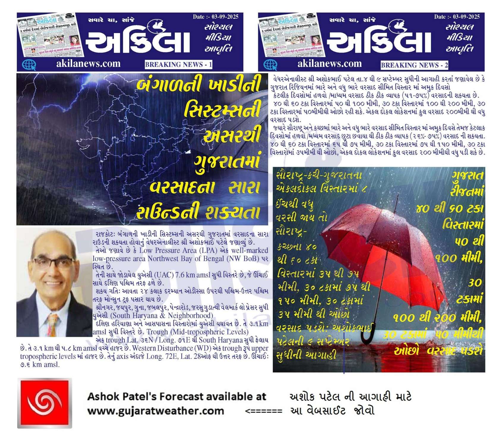
Rainfall Forecast for Saurashtra, Kutch & Gujarat
Period: 4th to 9th September 2025
Gujarat Region – Cumulative Rainfall
- Heavy / Very Heavy rainfall is likely over Isolated areas on some days of the forecast period.
- Some days will see light to moderate rainfall over fairly widespread areas.
- 40% to 60% areas: 50 – 100 mm
- Up to 30% areas: 100 – 200 mm
- Up to 30% areas: could remain below 50 mm
- Stray locations: Could receive cumulative rainfall exceeding 200 mm
Saurashtra & Kutch – Cumulative Rainfall
- Intensity: Heavy / Very Heavy rainfall is likely over Isolated areas on some days of the forecast period.
- Some days will see light to moderate rainfall over scattered to fairly widespread areas
- 40% to 60% areas: 35 – 75 mm
- Up to 30% areas: 75 – 150 mm
- Up to 30% areas: could remain below 35 mm
- Stray locations: Could receive cumulative rainfall exceeding 200 mm

બંગાળ ની ખાડી ની સિસ્ટમ ગુજરાત રાજ્યમાં ફાયદારૂપ વરસાદી રાઉન્ડ આપે તેવી અપેક્ષા: 4th–9th સપ્ટેમ્બર 2025
હવામાન વિશ્લેષણ
(Based on 0530 hours IST of 03rd September 2025)
Low Pressure Area (LPA)
- એક well-marked low-pressure area Northwest Bay of Bengal (NW BoB) પર સ્થિત છે.
- તેની સાથે જોડાયેલ યુએસી (UAC) 7.6 km amsl સુધી વિસ્તરે છે, જે ઊંચાઈ સાથે દક્ષિણ પશ્ચિમ તરફ ઢળે છે.
- શક્ય ગતિ: આવતા 24 hours દરમ્યાન Odisha ઉપરથી પશ્ચિમ-ઉત્તર પશ્ચિમ તરફ.
Monsoon Trough (Mean Sea Level)
- Monsoon trough પસાર થાય છે:
Sri Ganganagar → Jaipur → Guna → Jabalpur → Pendra Road → Jharsuguda → center of well-marked LPA (NW BoB) → East-central Bay of Bengal
યુએસી (South Haryana & Neighborhood)
- South Haryana અને આસપાસના વિસ્તારોમાં યુએસી યથાવત છે.
- તે 3.1 km amsl સુધી વિસ્તરે છે.
Trough (Mid-tropospheric Levels)
- એક trough Lat. 36°N / Long. 71°E થી South Haryana સુધી ફેલાય છે.
- તે 3.1 km થી 5.8 km amsl વચ્ચે હાજર છે.
Western Disturbance (WD)
- એક trough રૂપે upper tropospheric levels માં હાજર છે.
- તેનું axis અંદાજે Long. 72°E, Lat. 28°N થી ઉત્તર તરફ છે.
- ઊંચાઈ: 7.6 km amsl.
વરસાદી આગાહી – Saurashtra, Kutch & Gujarat
સમયગાળો: 4th થી 9th September 2025
ગુજરાત રિજિયન: કુલ વરસાદ
- ભારે અને વધુ ભારે વરસાદ સીમિત વિસ્તાર માં અમુક દિવસો
- કેટલાક દિવસોમાં હળવો /મધ્યમ વરસાદ ઠીક ઠીક વ્યાપક (51–75%) વરસાદ ની શક્યતા.
- 40% to 60% areas: 50 – 100 mm
- 30% વિસ્તાર સુધી: 100 – 200 mm
- 30% વિસ્તાર સુધી: 50 mm થી ઓછો રહી શકે.
- એકલ દોકલ લોકેશન માં : કુલ વરસાદ 200 mm થી વધુ મળી શકે.
સૌરાષ્ટ્ર અને કચ્છ: કુલ વરસાદ
- ભારે અને વધુ ભારે વરસાદ સીમિત વિસ્તાર માં અમુક દિવસો
- કેટલાક દિવસોમાં હળવો /મધ્યમ વરસાદ છુટા છવાયા થી ઠીક ઠીક વ્યાપક (26%–75%) વરસાદ ની શક્યતા.
- 40% to 60% areas: 35 – 75 mm
- 30% વિસ્તાર સુધી: 75 – 150 mm
- 30% વિસ્તાર સુધી: below 35 mm
- એકલ દોકલ લોકેશન માં : કુલ વરસાદ 200 mm થી વધુ મળી શકે.
⚠️ Advisory
Caution: Please refer/rely on IMD/RSMC Bulletins/Advisories for Storms & Weather related matter.
સાવચેતી: સ્ટોર્મ કે હવામાન અંગે ની માહિતી માટે ભારતીય હવામાન ખાતા/ગવર્મેન્ટ ના બુલેટીન/સુચના પર નિર્ભર રહેવું.
Read Comment Policy – કમેન્ટ માટે માર્ગદર્શન વાંચો
How To Upload Profile Picture For WordPress – વર્ડપ્રેસ માં પ્રોફાઈલ પિક્ચર કેમ રાખવું
Forecast In Akila Daily Dated 3rd September 2025
Forecast In Sanj Samachar Daily Dated 3rd September 2025
Atyar sudhi jya ochu batavtu hatu tya bhi varsad thyo che
Etle upper vada per bharoso rakho
A round badhane aashirvad aapse
Model a vakhte bilkul accurate nathi
ઞામ્્ખોલડીયાદ .તા.વઢવાણ જી.સુ.નગર
ધીમી ધારે વરસાદ ચાલુ થયો છે
લેટેસ્ટ સેટેલાઈટ ઇમેજ માં સમગ્ર ગુજરાત પર વાદળ છે ને રાજકોટ માં છાંટો પણ નથી. સુરેન્દ્રનગર વાળી ગાડી પોચી જાય તો સારું. કે પછી રાજકોટ વાસીઓ ને કાયમી નિંદ્રા માં હોય ત્યારે અડધી રાત્રે કડાકા ભડાકા સાથે ચાલુ થાય. આ વર્ષે એક પણ વાર એવો વરસાદ આવ્યો નથી.
ગાડી મૉરબી પૉચી હે હવે કેટલૉ આવે હે ભાગમા જૉય ગાજવીજ બવ થાય હે મૉરબી થી ઉતર પુર્વ દીશા મા
Je jagya par Thunderstorm bane tya j varse baki aagad bhag ma chhanta aave
Aaje pan ema j thayu chhe…
Sir Bafaro che Jordar Varsad avse…???
Most probably kal savar thi bapor pachi North and North Central Gujarat ma varsad ni jor vadhse ane Sunday sudhu lambase.
Aa maru manvanu che
Extremely heavy rains with thunderstorm in Vadodara
8 thi 10 ma 2mm varsad nodhayu che GSDMA ma jyare VMC ma 40mm+ che kale IMD nu figure su ave che joiye.
Khota figures che… I think 2 inch jetlo padi gayo che. Varsad ni intensity ketli jordar hati to khali 2 mm thodi hoy… Absolutely wrong.
Surendranagar ma heavy varsad chalu
પવન પણ જોરદાર છે
15 minit nu જોરદાર ઝાપટું આવી ગયું surprise વરસાદ આવ્યો વીજળી થતી હતી મોડી રાત્રે આવે એવુ લાગતુ હતું surprise મળ્યું.
અને વરસાદ ની વરસવાની ઝડપ થોડી વાર મા પાણી પાણી થય જાય છે. (Like extremely heavy rain)
સર અમારા થી ઉત્તર પુર્વ માં સાંજ થી જબરદસ્ત વીજળી થાય છે હજુ પણ જોરદાર વીજળી ચાલુ છે અને મેઘગર્જના પણ સંભળાય છે.તે બાજુ જોરદાર વરસાદ હશે.
અને અમારે છાંટો છાંટો વરસાદ ચાલુ છે,
જોઈએ હવે પછી શું થાય છે
Low ma વધારે પવન હોય કે ડિપ્રેશન માં વધારે હોય
Low ma pavan hoy tenathi well marked low ma vadhu pavan and tenathi Depression ma vadhu pavan hoy.
Kainathi khali laitig 6
Manavadar baju varsad ni shakyata kevi????
Ahmedabad ma aaje saro chance miss thai gayo , 2 days to go
Bhai hu khub pldyo aaje akhbar nagar baju but only for 10 mins 🙂 bdhe vij chmkara thtata pn yes Miss thyu 🙂
Vadodara sama vistara ma bhuka bolave che.
Akha Vadodara ma bhukka bolave che bhai very heavy rains..
આજે પણ સારો વરસાદ વરસી રહ્યો છે અમારે 15 મિનિટ થઈ છે ચાલુ છે
સુરત શહેર માં ભારે પવન સાથે ધોધમાર વરસાદ શરૂ…લગભગ 20 મિનિટ થી શરૂ છે
Rainfall data update
અમારાથી પુર્વ મા વીજળી ના ચમકારા દેખાય છે
જૉઇએ કાલ ની જેમ ગાડી પૉચે છે કે નય
સુરેન્દ્રનગર વારા મિત્રો કેજૉ ચાલુ થયૉ તમારે
to aavi jahe…
amare kal tamari baju dekhata hata ne aavi gyo to thodok
ભાઈ ૧ કલાક થી વીજળી થાય છે પણ વરસતું નથી…..ટેન્કર ખાલી લાગે છે
IMD ની બુલેટિન જોતા રેજો.
૪૮ કલાક ખૂબ ભારે છે.
અત્યાર ના બુલેટિન મુજબ કોઈ જગ્યા એ ૩૦cm થી વધારે વરસાદ પણ થઈ શકે છે.
બની શકે તો બિનજરૂરી ટ્રાવેલિંગ ટાળવું.stay safe.
30cm nu kye 6e ee 5 cm to aavse ne?
Ketla vistar ma te bhegu lakho.
ઉત્તર ગુજરાત મા પડશે
Ahmedabad dhokla ma gajvij jode bhukka bolvididha
લો માંથી પાછી વેલ માર્કેડ થઈ એ કઈ પરિબળો ના લીધે
Pahela low thay pachhi majboot thay tyare Well marked kahevay. And Nabadu padey etle Low kahevay.
અમારે વરસાદે દે ધનાધન વાળી કરી આજે સાંજના ૫૦:૩૦ થી ૭ વાગ્યા સુધીમા પાણી પાણી થઈ ગયુ
This is my first comment on the Gujarat Weather page, and I would like to ask for some clarification regarding the ongoing weather system and its likely impact on Rajkot. It seems that when a system is positioned more towards the southern parts of Rajasthan and northern parts of Gujarat, its benefits in terms of rainfall for Rajkot are limited. However, if the system is located a bit more towards the south, Rajkot tends to receive more significant rainfall. Is this observation correct? Also, I have noticed that the IMD GFS Precipitation Charts are currently showing reduced rainfall potential over… Read more »
Welcome to the Blog.
This is a School and everyone here is a student including me.
Looking for Answers for Rajkot, you have many tools that you can see. IMD GFS Precipitation Maps. They change every 6 hours so watch them.
Also by popular demand a new set of Precipitation Charts are introduced known as KOLA charts.
See the Menu link for those charts. There are various Models as well as features. KOLA -India and KOLA-West.
You need to check KOLA west in all models. You will get your answer.
બ્લોગમાં આપનું સ્વાગત છે.
આ એક શાળા છે અને અહીં મારા સહિત દરેક વિદ્યાર્થી છે.
રાજકોટ માટે જવાબો શોધી રહ્યા છો, તો તમારી પાસે ઘણા બધા સાધનો છે જે તમે જોઈ શકો છો. IMD GFS વરસાદ નકશા. તે દર 6 કલાકે બદલાય છે તેથી તેમને જુઓ.
લોકપ્રિય માંગ મુજબ વરસાદ ચાર્ટનો એક નવો સેટ KOLA ચાર્ટ તરીકે ઓળખાય છે.
તે ચાર્ટ માટે મેનુ લિંક જુઓ. વિવિધ મોડેલો તેમજ સુવિધાઓ છે. KOLA -ભારત અને KOLA-પશ્ચિમ.
તમારે બધા મોડેલોમાં KOLA પશ્ચિમ તપાસવાની જરૂર છે. તમને તમારો જવાબ મળશે.
Ramaji Bhai tame to ochu bhanela so toy aatlu sarash Gujarati kari didhu
પરંતુ સર, KOLA NOAA સિવાય તો બાકી કોઈ મોડેલ રાજકોટ અને તેનાથી પશ્ચિમ બાજુ વરસાદ ના ખૂબ ઓછા ચાન્સ બતાવે છે, તો જવાબ એવો આવે કે વરસાદના ચાન્સ ઓછા છે. બીજી બાજુ એવું પણ થઈ છે કે next day next update માં chances વધી જાય અથવા સાવ ઘટી જાય, તો એમાં અંદાજ માં precision કેવી રીતે લેવું? અલગ અલગ મોડેલ અલગ અલગ અંદાજ અને અધૂરામાં પૂરું update to update scenario change થયા રાખે….
Etle bahu chagi na javay…..maape maape rahevay !
બરોબર છે સર..
Ra rakhi ne
You are from?
Welcome
ગુજરાત હવામાન પૃષ્ઠ પર આ મારી પહેલી ટિપ્પણી છે, અને હું ચાલુ હવામાન પ્રણાલી અને રાજકોટ પર તેની સંભવિત અસર અંગે થોડી સ્પષ્ટતા માંગવા માંગુ છું. એવું લાગે છે કે જ્યારે કોઈ સિસ્ટમ રાજસ્થાનના દક્ષિણ ભાગો અને ગુજરાતના ઉત્તરીય ભાગો તરફ વધુ સ્થિત હોય છે, ત્યારે રાજકોટ માટે વરસાદના સંદર્ભમાં તેના ફાયદા મર્યાદિત હોય છે. જો કે, જો સિસ્ટમ દક્ષિણ તરફ થોડી વધુ સ્થિત હોય, તો રાજકોટમાં વધુ નોંધપાત્ર વરસાદ પડે છે. શું આ અવલોકન સાચું છે? ઉપરાંત, મેં નોંધ્યું છે કે IMD GFS વરસાદ ચાર્ટ હાલમાં સૌરાષ્ટ્ર પ્રદેશમાં વરસાદની ઓછી સંભાવના દર્શાવે છે. આ જોતાં, શું તમે કૃપા કરીને… Read more »
Atyar ni sanj ni latest GFS update mujab system thodi niche rahi ske etle kutch border pr pn hju pn track final j nathi em kahi skay kutch pr thi arbi ma pn jai ske Sidhi etle every update ma Track change thai rhyo che.
Sir aje bapor ni imd mid day update ma majbut uac arabian sea lagu gujarat Katha agad che to enathi varsad no labh na mle coastal area ne ? Mins avdu majbut uac che etle ?
Bahodu Circulation 700 hPa kaam aavey
OK sir
Sir aa system ma patan and banaskantha ma kevo varshad rehse
Vadhu varsad samjo…Bhare varsad
Hello sir Rajkot Jilla na jasdan ma avta divso ma kevo chance che
Possible hoy to Answer apjo
લગભગ બધા મોડલમાં ઉતર ગુજરાત અને કચ્છ માટે ભારે વરસાદ દર્શાવે છે.
લગભગ બધા મોડલમાં ઉતર ગુજરાત અને કચ્છ માટે ભારે વરસાદ દર્શાવે છે.
IMD satellite + windy satellite+windy radar + windy thunderstorm …. આ બધા માં ગાઢ વાદળો નો સમૂહ દક્ષિણ ગુજરાત અને ગુજરાત રિજિયન બાજુ થી સુરેન્દ્રનગર મોરબી પર આવતા બતાવે છે…….જોઈએ કેટલું પાણી જમીન પર પડે છે અને ક્યાં પડે છ…..અમદાવાદ અને ધોળકા બાજુ ના મિત્રો જણાવજો કે વરસાદ,thunder છે કે નહીં ….મતલબ ટેન્કર ભરેલા છે કે ખાલી નીકળે છે?
ધોળકામાં હા વરસાદ થયો છે જોરદાર કડાકા સાથે 7 થી 8 વાગ્યા સુધી…હાલ દક્ષિણ અને પૂર્વ બાજુ વીજળી ચાલુ છે 8.47 pm
Ahmedabad vala mitro be alert!! Tamare 2 diwas ma 150 to 200 mm varsad batave che karanke system tamari upar thi pass thay che.
Su be alert yaar 3nek inch pde toy bhyo bhyo bro 🙂 hahaha
Huge cloud cover but no rain until.
Vijdi thai che.
Joiye su thaye che aagad
સર આજે વરસાદ સાવ બંધ સે કાલે રાત્રે એક ઝાપટુ આવ્યુ હતુ હવે અમારી બાજુ શક્યતા ઓશી ગણવી કે હજી આવસે
Happy Teacher’s Day Ashok Sir 🙂
Weather related + life ma sikhva jevu biju bhi ghnu sikhvadyu aape
Tme cho to ghni mja che life ma 🙂 ane a bdal Thank you aapne 🙂
Mitro mara manava mujab aa round ma junagadh ane porbandar na vistaroma mape varsad padashe vadhu nahi pade.Jay Shree Radhe Krishna Ji…
Saru aevu pan nikadi Jay varshad rupe aetale bus junagadh ni aaspas ma
જો સિસ્ટમ મજબૂત બને તો શું ભારે વરસાદનું ક્ષેત્ર ઓછું અને વધુ કેન્દ્રિત થશે?
System babat mslp and 925 na chart jovo etle andaj aavey. Depression hoy etle Vadhu kendrit hoy. System dhimi chaley etle vadhu jagya cover thai shakey.
સર રમકડાં નું મેનુ ખૂલતું નથી 3લીટા બીજી સાઈડ માં જતાં રયા છે
Saav Nicche scroll karo etle Menu dekhashe aakhu
ok ok thank you sir
Atyarni updet windy gfs ma bhukka bolave avu chhe jamnagar morabi surendra nagar have joy su thay
સર..પૉરબંદર દ્વારકા વાળા પક્ષીમ પટાટામા આ સીસ્ટમની અસર ઑછી રહે એવુ લાગે છે. ઉપર ના લેવલે ભેજ વગર ના પવનૉ ઉતર પક્ષિમ બાજુ થી આવે છે એ કારણ હશે કે પછી સીસ્ટમનૉ મજબુત હૉય તૉ તેનૉ ટ્રફ લંબાતૉ ન હૉય એવુ બને
સર તમે સવારે કીધું અને અત્યારે 20મિનિટ થી ભૂક્કા કાઢવાનું ચાલુ છે
સર અમારે પક્ષિમ સૌરાષ્ટ્ર વાળા ને આ રાઉન્ડ માં વારો આવશે….? પોરબંદર જિલ્લામાં plz answer sir
Sir Mari last comment aavi nay Kai locho hato tema ?
Yes
Depression declare IMD kare Vavazoda ni kem
Baaki chhela 4 divas thaya mslp North Gujarat Kutch baju nichu j batavey chhe.
Mslp means ?
Mean Sea Level Pressure ahi Menu ma chhe IMD nu
System na track ma fer far modelo ni dar update ma thai rhyo che sathe varsad ni matra ma pn etle hju Asha che ke porbandar sahit coastal arae ma varsad avi ske
Latest atyare imd Mid day bulletin ma Arabin sea ma Gujarat coast agad uac che enathi varsad pde che ke nai jovanu rhyu
આજે શિક્ષક દિન ના પાવન પર્વે આપણા હવામાન ગુરુ શ્રી અશોકભાઈ પટેલ ને કોટી કોટી વંદન
Sir asistam utar gujrat kuch uparthi jay tya re ડીપ્રેશન ma fervay to સુરેન્દ્રનગર નગર મોરબી. જામનગર રાજકોટ ne santosh karak varsad thay sake
Varsad na map avata 10 divas na chhe j.
Amato kya batave chhe japta
સર, શું આ વરસે પહેલી વાર મોન્સુન હિમાલય ને પાર કરી ને તિબેટ માં ગયું છે?? એવું મેં એક રિપોર્ટ માં વાંચ્યું છે. તો sir શું એ ગ્લોબલ વોર્મિંગ ના કારણે થઈ રહું છે ને એની આવનાર દિવસો માં શું અસર થાય? શું હિમ વર્ષા નો વિસ્તાર પણ વધે કે પછી ઘટે?
Sansanaati vadhu
Sir ak quation chhe
Jo system catch upar hoy ane D ma fervay to
Sauratra na vadhu labh male jem ke jamnagar.morabi surendranagar.rajkot
Etle ?
Pankaj Bhai aevu kaheva mage che k system Kutch upr hoy Ane dipression ma fervay to jnavela vistar ma varsad no labh madi shake ..?
Kutch ma hoy toe Jamnagar District ne laabh hoy.
પ્રતીક ભાઈ એ આપેલ અપડેટ માં પહેલી વાર એવું બન્યું કે સિસ્ટમ wmlp માં થી મજબૂત થઈ ને ડિપ્રેશન થવાની શક્યતા છે. તો નોર્થ ગુજરાત ને લાગુ રાજસ્થાન ના ભુક્કા નીકળી શકે. હવે સિસ્ટમ નીચી આવવાના ચાન્સ ખરા ? તો રાજકોટ જિલ્લા ને પણ વરસાદ નો લાભ મળે.
Aaje KOLA IMD BharatFS Precipitation Charts Add karya chhe.
Aavo varsad chomasama aaje peli var aaviyo aekaj dharo bhukka kadhe 6e
Ketla inch padyo???
આ સિસ્ટમ માં પવન નું જોર રહશે?
Jyan System hoy tyan pavan toe hoy j
Sir imd say exceptionally 30 cm and more rainfall in 24hr on 6th September add in today’s mid-day update
It’s look like serious situation during ambaji melaaa in North Gujarat
Yes people should be vigilant.
હું અંબાજી માં જ છું.. મેળા દરમિયાન ડ્યુટી આપેલ છે છેલ્લા 7 દિવસથી…
Khayal rakhana bhai
Aje dariyay Patti vistaro Veraval sutrapada junagadh an vistaro ma varsad che etle porbandar ma pn Asha Jagi che ke 1 thi 2 inch pdi jase aaj vatavarn atyare saru che varsadi ane kok vaar chaata pdi jai che.
Jay matajiii sir…. Sir Aa varse Amara vistar ma gya vars ni sarkhamaniye santoskarak Ane vdhare tivrta valo varsad aavyo j nathiii… Tmari update 4th-9th sep.ni che. to aa vakhte Amaro varo aavi jse…. Plz…reply….