Southwest Monsoon Sets In Over Parts of Coastal Saurashtra and Parts of Gujarat Region Today 16th June 2025
દક્ષિણ પશ્ચિમ ચોમાસું કોસ્ટલ સૌરાષ્ટ્ર ના ભાગો તેમજ ગુજરાત રિજિયન ના ભાગો માં આજે તારીખ 16th June 2025 ના પ્રવેશ્યું
Current Weather Conditions – 16th June 2025
The Southwest Monsoon has further advanced into the following regions:
- Entire Konkan and Madhya Maharashtra
- Parts of Coastal Saurashtra and parts of Gujarat Region
- Southwest Madhya Pradesh
- Some more parts of Vidarbha, Chhattisgarh, Odisha
- Sub-Himalayan West Bengal & Sikkim (partial advancement)
Current Synoptic Conditions
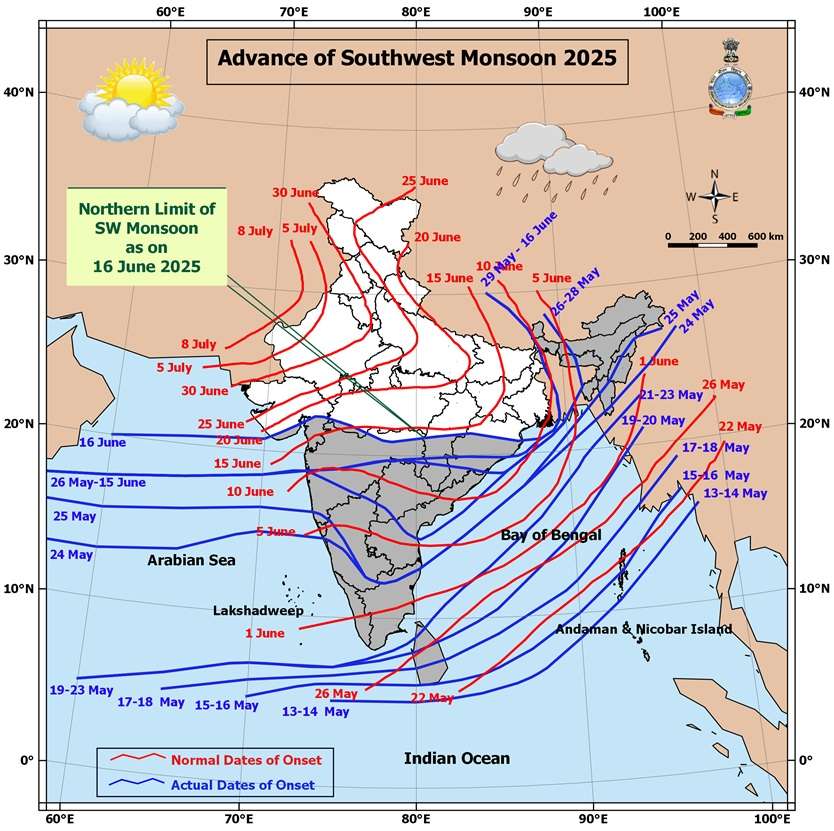
Northern Limit of Monsoon (NLM)
As of 16th June 2025, the Northern Limit of Monsoon passes through:
20.0°N/60°E, 20.5°N/65°E, Veraval, Bhavnagar, Vadodara, Khargone, Amravati, Durg, Bargarh, Chandbali, Sandhead Island, 23.5°N/89.5°E, Balurghat, and 30.0°N/85.0°E
Monsoon Advancement Outlook
Favorable conditions are expected for further advancement of the Southwest Monsoon into:
- More parts of Gujarat and Madhya Pradesh
- Remaining parts of Vidarbha
- More parts of Chhattisgarh and Odisha
- Remaining parts of Sub-Himalayan West Bengal & Sikkim (within the next 24 hours)
- Parts of West Bengal, Jharkhand, Bihar, and East Uttar Pradesh (during the subsequent 2 days)
Synoptic Features
- An upper air cyclonic circulation lies over the Northwest Bay of Bengal and adjoining areas, tilting southwestward with height in the lower and middle tropospheric levels.
- Another cyclonic circulation is observed over South Gujarat and nearby regions in the middle tropospheric levels.
- Under its influence, a Low-Pressure Area is likely to form over the same region in the next 24 hours.
- It is expected to move north-northwestwards and become more marked in the following 24 hours.
Also refer to the forecast update dated 14th June 2025 for additional context
️
દક્ષિણ પશ્ચિમ ચોમાસું કોસ્ટલ સૌરાષ્ટ્ર ના ભાગો તેમજ ગુજરાત રિજિયન ના ભાગો માં આજે તારીખ 16th June 2025 ના પ્રવેશ્યું
️
તારીખ: 16મી જૂન 2025
વર્તમાન હવામાન સ્થિતિ – 16મી જૂન 2025
દક્ષિણ પશ્ચિમ ચોમાસું આગળ વધીને નીચેના વિસ્તારોમાં પ્રવેશી ગયું છે:
-
સમગ્ર કોંકણ અને મધ્ય મહારાષ્ટ્ર
-
કોસ્ટલ સૌરાષ્ટ્ર ના ભાગો તેમજ ગુજરાત રિજિયન ના ભાગો માં
-
દક્ષિણ પશ્ચિમ મધ્ય પ્રદેશ
-
વિદર્ભ, છત્તીસગઢ, ઓડિશાના કેટલાક વધુ ભાગો
-
સબ-હિમાલયન પશ્ચિમ બંગાળ અને સિક્કિમના કેટલાક ભાગો
ચોમાસાની ઉત્તરી સીમા (NLM)
16મી જૂન 2025ની સ્થિતિ મુજબ, ચોમાસાની ઉત્તર સીમા નીચેના સ્થળોમાંથી પસાર થાય છે:
20.0°N/60°E, 20.5°N/65°E, વેરાવળ, ભાવનગર, વડોદરા, ખંડવા, અમરાવતી, દુર્ગ, બરગઢ, ચાંદબલી, સેન્ડહેડ આઈલેન્ડ, 23.5°N/89.5°E, બાલુરઘાટ અને 30.0°N/85.0°E
ચોમાસું આગળ વધવાનો અંધાજ
ચોમાસું આગળ વધવા માટે પરિસ્થિતિ અનુકૂળ છે, અને તે નીચેના વિસ્તારોમાં આગળ વધી શકે છે:
-
ગુજરાત અને મધ્ય પ્રદેશના વધુ વિસ્તારો
-
વિદર્ભના બાકી રહેલા વિસ્તારો
-
છત્તીસગઢ અને ઓડિશાના વધુ વિસ્તારો
-
સબ-હિમાલયન પશ્ચિમ બંગાળ અને સિક્કિમના બાકી રહેલા વિસ્તારો (આગામી 24 કલાકમાં)
-
પશ્ચિમ બંગાળ, ઝારખંડ, બિહાર અને પૂર્વ ઉત્તર પ્રદેશના કેટલાક ભાગો (આગામી 2 દિવસોમાં)
વાતાવરણીય પરિબળો
-
એક UAC ઉત્તર પશ્ચિમ બંગાળની ખાડી અને આસપાસના વિસ્તારોમાં જોવા મળે છે, જે નીચલા અને મધ્યમ સ્તરે ઊંચાઈ પર દક્ષિણ પશ્ચિમ તરફ ઢળી રહી છે।
-
બીજું એક UAC દક્ષિણ ગુજરાત અને નજીકના વિસ્તારોમાં મધ્યમ સ્તરે પ્રવર્તી રહ્યું છે।
-
તેની અસર હેઠળ, આગામી 24 કલાકમાં લો પ્રેસર આ વિસ્તારમાં વિકસવાની શક્યતા છે।
-
આ સિસ્ટમ ઉત્તર-ઉત્તર પશ્ચિમ દિશામાં ખસે તેવી સંભાવના છે અને તે આગળ WMLP બની શકે છે (આગામી 24 કલાકમાં).
- વધુ માહિતી માટે 14મી જૂન 2025ની આગાહી અપડેટ પણ જુઓ.
-
-
⚠️ Advisory
Caution: Please refer/rely on IMD/RSMC Bulletins/Advisories for Storms & Weather related matter.
સાવચેતી: સ્ટોર્મ કે હવામાન અંગે ની માહિતી માટે ભારતીય હવામાન ખાતા/ગવર્મેન્ટ ના બુલેટીન/સુચના પર નિર્ભર રહેવું.
Read Comment Policy – કમેન્ટ માટે માર્ગદર્શન વાંચો
How To Upload Profile Picture For WordPress – વર્ડપ્રેસ માં પ્રોફાઈલ પિક્ચર કેમ રાખવું
Forecast In Akila Daily Dated 16th June 2025
Forecast In Sanj Samachar Daily Dated 16th June 2025
દક્ષિણ ગુજરાત અને તેના આસપાસના વિસ્તારો પર UAC ના પ્રભાવ હેઠળ, આજે ૧૭ જૂન ૨૦૨૫ ના રોજ ભારતીય સમય મુજબ સવારે ૦૫.૩૦ કલાકે ગુજરાત અને તેના આસપાસના વિસ્તારોમાં લો પ્રેશર રચાયુ છે. આગામી ૨૪ કલાક દરમિયાન આ સીસ્ટમ વધુ તીવ્ર બને અને ઉત્તર-ઉત્તરપશ્ચિમ તરફ આગળ વધે તેવી શક્યતા છે.
Mari coment kem dekhati nathi
Aa Messenger service nathi.
Hu 24 kalak tamari comment nu rakholu nathi rakhto.
Samay madye tamari comment na jawab aapu chhu !
Vadhu vigat ahi aapel chhe Comment Policy – ટિપ્પણી (કમેન્ટ) માટે માર્ગદર્શન
Ahmedabad Dholka
Bhare pavan ane gajvij jode dodhmar varsad poni kalak thi
અપડેટ બદલ ખુબ ખુબ આભાર
Sir aje rajkot no varo vase
તારીખ 17 જુન 2025 આજની પરિસ્થિતિ ભારતીય હવામાન વિભાગ અનુસાર મીડ ડે બુલેટિન ❖ નૈઋત્ય નું ચોમાસું આજે ઉત્તર અરબી સમુદ્ર અને ગુજરાતના કેટલાક ભાગો અને વિદર્ભના બાકીના ભાગો, મધ્ય પ્રદેશના વધુ ભાગો; છત્તીસગઢના મોટાભાગના ભાગો; ઓડિશાના બાકીના ભાગો; ઝારખંડના કેટલાક ભાગો; સમગ્ર ગંગીય પશ્ચિમ બંગાળ અને સબ-હિમાલયન પશ્ચિમ બંગાળના બાકીના ભાગો અને બિહારના કેટલાક ભાગોમાં આગળ વધ્યું છે. ❖ નૈઋત્ય ના ચોમાસાની રેખા હવે 24.0°N/60°E, 24.0°N/65°E, ડીસા, ઇન્દોર, પંચમઢી, મંડલા, અંબિકાપુર, હજારીબાગ, સુપૌલ અને 29.0°N/84.0°E માંથી પસાર થાય છે. ❖ નૈઋત્ય નું ચોમાસું આગામી 2 દિવસ દરમિયાન ઉત્તર અરબી સમુદ્ર અને ગુજરાતના બાકીના ભાગો; રાજસ્થાનના કેટલાક ભાગો; મધ્ય પ્રદેશના… Read more »
Update aapel hoy tyan post karjo
Thanks
Shihora vignesh bhai ne aa vakhte starting ma j kudrat e moj karavi didhi che Gaya vakhte last sudhi tention ma hata karo moj bhai
હાં જયદીપભાઈ…..હવે તો તળાવ તૂટવા ની પોઝિશન થઈ ગઈ છે…..આખું ગામ ત્યાં કામે લાગ્યું છે …..હું પણ….ખેતરૂ પાણી થી તરબોળ થઈ ગયા ને પાણી બંધ તોડી ને જવા લાગ્યા…..
Sir su tsunami k earthquake avano hoi to enu forecast agav thi khyal avi sake?
Earthquake aavey tyare Stunami ni aagahi thai shakey chhe.