Depression Over Southeast Arabian Sea — Unseasonal Isolated/Scattered Light to Heavy Rain Expected Over Saurashtra, Gujarat & Kutch During 25th–30th October 2025
દક્ષિણ પૂર્વ અરબી સમુદ્ર પર ડિપ્રેશન સિસ્ટમ – સૌરાષ્ટ્ર ગુજરાત અને કચ્છ માં સિમીત/છુટા છવાયા વિસ્તાર માં કમોસમી હળવો મધ્યમ ભારે વરસાદ ની શક્યતા 25 થી 30 ઓક્ટોબર 2025
23rd October 2025
Current Weather Conditions:
Meteorological Analysis (Based on 0830 hours IST, 23 October 2025)
Depression over Southeast Arabian Sea:
The Depression over the southeast Arabian Sea moved slowly northeastwards with a speed of about 5 kmph during the past 6 hours and lay centered at 0830 hrs IST of today, the 23rd October 2025, over the same region, near latitude 9.8°N and longitude 67.8°E. It was located approximately 560 km west-southwest of Aminidivi (Lakshadweep) and 910 km southwest of Panjim (Goa). It is likely to move nearly north-northeastwards across the southeast Arabian Sea towards the east-central Arabian Sea during the next 24 hours.
Low Pressure Area over South Interior Karnataka:
The low pressure area over north interior Tamil Nadu and adjoining south interior Karnataka moved west-northwestwards and lay over south interior Karnataka and neighborhood at 0830 hours IST of today, the 23rd October 2025. The associated cyclonic circulation extended up to middle tropospheric levels. It is likely to continue moving west-northwestwards across south Karnataka and emerge over the east-central and adjoining southeast Arabian Sea during the next 24 hours.
Cyclonic Circulation over Southeast Bay of Bengal:
The upper air cyclonic circulation over the south Andaman Sea and neighborhood now lies over the southeast Bay of Bengal and adjoining south Andaman Sea, extending up to 5.8 km above mean sea level. Under its influence, a low pressure area is likely to form over the southeast and adjoining east-central Bay of Bengal on 24th October 2025.
It is likely to move west-northwestwards and become more marked during the subsequent 24 hours.
Other Systems:
-
The upper air cyclonic circulation over northwest Uttar Pradesh and adjoining Haryana at about 3.1 km above mean sea level persists.
-
The Western Disturbance, seen as a trough in the middle and upper tropospheric westerlies, now runs roughly along Longitude 78°E to the north of Latitude 30°N, with its axis at about 5.8 km above mean sea level.
-
A fresh Western Disturbance is likely to impact the Western Himalayan Region from 27th October 2025.
Forecast For Saurashtra, Gujarat & Kutch 25th To 30th October 2025
Currently, the Depression over the Arabian Sea is positioned well away from the Saurashtra and Gujarat coasts.
However, dense clouding associated with the system extends across the east-central Arabian Sea.
Historically, very few Arabian Sea systems have moved north of 20°N latitude.
Nevertheless, under the influence of this system and its associated clouding, there is a moderate possibility of unseasonal light to moderate rainfall, with isolated heavy spells, over isolated to scattered areas of Saurashtra, Gujarat, and Kutch during 25–30 October 2025. More possibility over Coastal Areas of South Gujarat and Saurashtra.
The confidence level for this forecast is medium, as different forecast models show varying scenarios. Among them, the ECMWF model indicates the highest rainfall potential, while the IMD GFS model shows the lowest rainfall prospects for Saurashtra, Kutch, and Gujarat. The Depression and other Systems will be closely monitored. Update will be given if required.
UW – CIMMS Satellite Images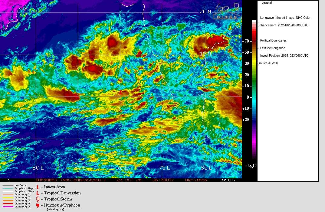
દક્ષિણ પૂર્વ અરબી સમુદ્ર પર ડિપ્રેશન સિસ્ટમ – સૌરાષ્ટ્ર ગુજરાત અને કચ્છ માં સિમીત/છુટા છવાયા વિસ્તાર માં કમોસમી હળવો મધ્યમ ભારે વરસાદ ની શક્યતા 25 થી 30 ઓક્ટોબર 2025
હવામાન વિશ્લેષણ (ભારતીય પ્રમાણ સમય મુજબ 0830 કલાકે, 23 ઓક્ટોબર 2025)
દક્ષિણપૂર્વ અરબી સમુદ્ર પરનું ડિપ્રેશન:
દક્ષિણપૂર્વ અરબી સમુદ્ર પર આવેલું ડિપ્રેશન છેલ્લા 6 કલાક દરમિયાન આશરે 5 કિ.મી./કલાકની ઝડપે ધીમે ધીમે ઉત્તરપૂર્વ દિશામાં ખસ્યું અને આજના રોજ, 23 ઓક્ટોબર 2025ના રોજ સવારે 0830 કલાકે, તે એ જ વિસ્તાર પર કેન્દ્રિત હતું, આશરે અક્ષાંશ 9.8°ઉત્તર અને રેખાંશ 67.8°પૂર્વ પાસે.
તે અમીનદીવી (લક્ષદ્વીપ) થી લગભગ 560 કિ.મી. પશ્ચિમ-દક્ષિણપશ્ચિમમાં અને પણજીમ (ગોવા) થી આશરે 910 કિ.મી. દક્ષિણપશ્ચિમમાં સ્થિત હતું.
આ સિસ્ટમ આગામી 24 કલાક દરમિયાન દક્ષિણપૂર્વ અરબી સમુદ્ર પરથી ઉત્તરપૂર્વ દિશામાં ખસીને પૂર્વ-મધ્ય અરબી સમુદ્ર તરફ આગળ વધવાની શક્યતા છે.
દક્ષિણ આંતરિક કર્ણાટક પરનું નીચા દબાણનું ક્ષેત્ર:
ઉત્તર આંતરિક તમિલનાડુ અને લાગુ દક્ષિણ આંતરિક કર્ણાટક પર આવેલું લો પ્રેસર ક્ષેત્ર પશ્ચિમ-ઉત્તરપશ્ચિમ દિશામાં ખસીને દક્ષિણ આંતરિક કર્ણાટક અને આસપાસના વિસ્તારમાં આજે સવારે 0830 કલાકે, 23 ઓક્ટોબર 2025ના રોજ સ્થિત હતું. તે સાથે જોડાયેલું યુએસી 5.8 કિમિ સુધી વિસ્તરેલું હતું.
આ સિસ્ટમ આગામી 24 કલાક દરમિયાન પશ્ચિલાગુ મ-ઉત્તરપશ્ચિમ દિશામાં ખસીને દક્ષિણ કર્ણાટક પરથી પસાર થઈને પૂર્વ-મધ્ય અને લાગુ દક્ષિણપૂર્વ અરબી સમુદ્ર ઉપર પહોંચવાની શક્યતા છે.
દક્ષિણપૂર્વ બંગાળની ખાડી ઉપરનું ચક્રવાતી પરિભ્રમણ:
દક્ષિણ અંડમાન સમુદ્ર અને આસપાસના વિસ્તારમાં આવેલું યુએસી હવે દક્ષિણપૂર્વ બંગાળની ખાડી અને લાગુ દક્ષિણ અંડમાન સમુદ્ર ઉપર છે, જે સમુદ્ર સપાટીના સરેરાશ સ્તરથી આશરે 5.8 કિ.મી. ઊંચાઈ સુધી વિસ્તરેલું છે. તેના પ્રભાવ હેઠળ, 24 ઓક્ટોબર 2025ના રોજ દક્ષિણપૂર્વ અને લાગુ પૂર્વ-મધ્ય બંગાળની ખાડી ઉપર એક નવું લો પ્રેસર ક્ષેત્ર રચાવાની શક્યતા છે. તે પશ્ચિમ-ઉત્તરપશ્ચિમ દિશામાં ખસીને આગામી 24 કલાકમાં વધુ મજબૂત બનવાની શક્યતા છે.
અન્ય હવામાન સિસ્ટમો:
ઉત્તરપશ્ચિમ ઉત્તરપ્રદેશ અને લગોળ હરિયાણા ઉપર લગભગ 3.1 કિ.મી. ઊંચાઈએ આવેલું યુએસી યથાવત છે.
મધ્ય અને ઉપર ક્ષોભમંડલ પશ્વિમ પવનોમાં આવેલું વેસ્ટર્ન ડિસ્ટર્બન્સ હવે આશરે રેખાંશ 78°પૂર્વ અને અક્ષાંશ 30°ઉત્તરથી ઉત્તર તરફ 5.8 કિ.મી. ઊંચાઈએ એક ટ્રફ સ્વરૂપે ચાલે છે.
27 ઓક્ટોબર 2025થી નવી વેસ્ટર્ન ડિસ્ટર્બન્સ પશ્ચિમ હિમાલયીય પ્રદેશને અસર કરવાની શક્યતા છે.
આગાહી સૌરાષ્ટ્ર, ગુજરાત અને કચ્છ તારીખ 25 થી 30 ઓક્ટોબર 2025
હાલમાં અરબી સમુદ્ર પરનું ડિપ્રેશન સૌરાષ્ટ્ર અને ગુજરાતના કિનારાોથી ઘણું દૂર સ્થિત છે.
તેમ છતાં, સિસ્ટમ સાથે જોડાયેલા ઘન વાદળો પૂર્વ-મધ્ય અરબી સમુદ્ર સુધી ફેલાયેલા છે.
ઈતિહાસમાં, અરબી સમુદ્રની ખૂબ ઓછી સિસ્ટમો જ 20°ઉત્તર અક્ષાંશથી ઉપર સુધી પહોંચી છે.
તેમ છતાં, આ સિસ્ટમ અને તેના આનુસંગિક વાદળો ના પ્રભાવ હેઠળ, સૌરાષ્ટ્ર, ગુજરાત અને કચ્છના સીમિત થી છુટા છવાયા વિસ્તારો માં 25 થી 30 ઓક્ટોબર 2025 દરમિયાન બિનમોસમી હળવા થી મધ્યમ, તથા કેટલાક સ્થળોએ ભારે વરસાદની શક્યતા છે.
દક્ષિણ ગુજરાત અને સૌરાષ્ટ્રના કિનારાના વિસ્તારોમાં વરસાદની સંભાવના વધુ છે.
આ અનુમાનની વિશ્વસનીયતા મધ્યમ સ્તરની છે, કારણ કે વિવિધ અનુમાન મોડેલો અલગ દ્રશ્યો દર્શાવે છે.
તેમાં, ECMWF મોડેલ સૌથી વધુ વરસાદની સંભાવના બતાવે છે, જ્યારે IMD GFS મોડેલ સૌરાષ્ટ્ર, કચ્છ અને ગુજરાત માટે સૌથી ઓછી વરસાદની સંભાવના દર્શાવે છે. સિસ્ટમ નું નિરીક્ષણ ચાલુ રહેશે અને જરૂર જણાશે તો અપડેટ આપવામાં આવશે.
Caution: Please refer/rely on IMD/RSMC Bulletins/Advisories for Storms & Weather related matter.
સાવચેતી: સ્ટોર્મ કે હવામાન અંગે ની માહિતી માટે ભારતીય હવામાન ખાતા/ગવર્મેન્ટ ના બુલેટીન/સુચના પર નિર્ભર રહેવું.
Read Comment Policy – કમેન્ટ માટે માર્ગદર્શન વાંચો
How To Upload Profile Picture For WordPress – વર્ડપ્રેસ માં પ્રોફાઈલ પિક્ચર કેમ રાખવું
Forecast In Akila Daily Dated 23rd October 2025
Forecast In Sanj Samachar Daily Baaki chhe Dated 23rd October 2025
તારીખ 26 ઓક્ટોબર 2025 આજની પરિસ્થિતિ ભારતીય હવામાન વિભાગ અનુસાર મીડ ડે બુલેટિન 1. દક્ષિણ-પૂર્વ બંગાળની ખાડી પરનું ડીપ ડિપ્રેશન – **હાલની સ્થિતિ (26 ઓક્ટોબર 2025, સવારે 08:30 કલાક IST)** પાછલા 6 કલાકમાં 6 કિમી/કલાકની ઝડપે પશ્ચિમ-ઉત્તરપશ્ચિમ દિશામાં આગળ વધ્યું છે અને હાલમાં તે જ વિસ્તારમાં કેન્દ્રિત છે: **અક્ષાંશ 11.2°N| રેખાંશ 87.1°E** – પોર્ટ બ્લેર (આંદામાન-નિકોબાર)થી **620 કિમી પશ્ચિમે** – ચેન્નઈ (તમિલનાડુ)થી **780 કિમી પૂર્વ-દક્ષિણપૂર્વે** – વિશાખાપટ્ટનમ (આંધ્રપ્રદેશ)થી **830 કિમી દક્ષિણ-દક્ષિણપૂર્વે** – કાકીનાડા (આંધ્રપ્રદેશ)થી **830 કિમી દક્ષિણપૂર્વે** – ગોપાલપુર (ઓડિશા)થી **930 કિમી દક્ષિણ-દક્ષિણપૂર્વે** – **સંભવિત હિલચાલ અને તીવ્રતા** – આગામી 24 કલાકમાં લગભગ પશ્ચિમ-ઉત્તરપશ્ચિમ દિશામાં આગળ વધશે અને **ચક્રવાતી… Read more »
Porbandar City Ma Bapore 1 vaga baad thi light to moderate varsad chalu.
Porbandar na ajubaju na Gamo ma pn varsad
Jabardast U turn lidhi chhe system e. Surat thi Mumbai vachche landfall thai sake. Intensity jota south saurashtra ne haju bhare nuksan aavse. Western disturbance and system ni sanyukt asar thi East Central Gujarat and South Gujarat mate pan bhare chhe.
Sir…amare 30 minutes thi dhimi dhare varsad chalu chhe… vatavaran ghatu chhe…!
Sir badha model ganda thaya chhe samgra Saurashtra mate 1st sudhi to very heavy rainfall batave chhe n pachhi 3-4 days light to moderate so round to bav lambo n nukasan karak chhe
સરજી અમારે હજુ વરસાદ નથી ભગવાન ની દયા. પણ અશોક બાપુ અમારી સાઈડ કેવીક શક્યતા કલ્યાણપુર તાલુકા બાજુ.?
IMD ના લેટેસ્ટ બુલેટિન મુજબ સિસ્ટમ નો ટ્રેક હવે ઉત્તર- ઉત્તર પૂર્વ બતાવે છે. ને તમારી લાસ્ટ update માં હતું કે સિસ્ટમ માં કઈ ફેરફાર થશે તો નવી update આવશે. તો તમારી નવી update આવશે ? અને મારા મત મુજબ તમારી જે આગાહી હતી એના કરતાં પણ વધુ વરસાદ 8- 10 ઇંચ જેટલો અતિભારે કહી શકાય એવો પડ્યો. તો હવે નવી update માં વરસાદ ની માત્રા અને વિસ્તાર માં વધારો થઈ શકે. જો સિસ્ટમ આમ જ ચાલી તો હજુ 3- 4 દિવસ સૌરાષ્ટ્ર ને ધમરોળશે.
Update avi gai chhe
DEV BHUMI DWARKA MA JAMNAGR NI VACHE SIR VARSAD KEVOK
15 kalak thi vadhare dhimi dhare varashad have bandh thayo
Sir ante imd ne bija modelo Kora javu j pdyu ne Imd gfs badha ek rase ava madya Imd potanu judu chalavta hta track ma ane Modelo ma varsad nta batavta ane hve system rato raat recurve ane north east chalu kryu imd pramane.Sir Porbandar thi veraval patto hju Avta 30 kalak jokham che ne ?? Porbandar ma varsad ni asar nahivat che etle.
Yes coastal vistar ma
Ok sir ane atyare porbandar city ma varsad nu vatavarn thai rhyu che pavan ni speed khub vadhi gyi che vadda Dariya Kora jai che.
Dwarka ne bad karyu aa vakhte sir
પોરબંદરના વિસ્તારોમાં વરસાદ કેવો રહેશે
જયશ્રી કૃષ્ણ સર , સર આ તો આખા સૌરાષ્ટ્ર માં તાઃ 5 સુધીમાં, ખમદાઈણ કરી નાખસે , તાજી અપડેટ જોતા તો જોખમ વધતુ જાય છે એવુ લાગે છે , તૈયાર કોરીયો હાથમાંથી જુટવી લેશે .
અપડેટ ક્યાં જોઈ ? મારે તો 10 દિવસ ના IMD ના ચાર્ટ ખુલતા જ નથી
Ahi badhu uplabdh chhe.
સર કેશોદ બાજુ હજી કેટલી તારીખ સુધી જોખમ છે
30th Oct sudhi zokham ane varsadi vatavaran aa akhu week
મોડેલ પ્રમાણે જોઈએ તો હજી શરુઆત નહિવત થઇ છે,,હજી સુત્રાપાડા ની ઓલી કોર જ ફિલમ ચાલુ થઈ છે,સુત્રાપાડા,મહુવા,કુંડલા,રાજુલા,ભાવનગર બાજુ પણ, બાકી દક્ષિણ ગુજરાત તો ચાલુ જ છે,બાકી હરી કરે ઇ ખરી,,આંકડા વરસાદ ના જોઈને એવું લાગ્યું ભર ચોમાસુ છે,,
Sir tankara baju jokham kevu rechhe
Varsadi vatavaran aa akhu week rese
Sir WD Ni asar kya sudhi rehse..
And arbi ma depression che tene 500 hpa ni humidity kai asar kare ..
Depression ma UAC 5.8 etle ke 500hPa athva vadhu unchay sudhi UAC hoy.
Vividhh level ma Humidity hoy te Varsad ma vadharo karey
Vadodara ma kale ratre 8.30 thi light rain chalu che. More than 1 inch.
Sir Aaj to IMD GFS Gandu thyu pan evo varsad to aya nathi
Kem joie che tamare varsad atyare?
Surat ma ketla divas varsaad nu vatavaran rahese
31st Oct sudhi
અમારો ખૂણો ઝપટે ચડી ગયો આખી રાત અને હજુ ધીમીધારે યથાવત છે…કાંઠા થી 10km અંદર ના ભાગ માં સ્થિતિ ખરાબ થય ગય.ખેતરો ના ધોવાણ થયા છે…આગળ હવે જેવી કુદરત ની મરજી
Sir Rainfall data karo ne
Karya update….. Aaykhu faati jaay eva chhe.
Haha
Jamngr ma vadad chayu vatavarn che.
Varsad bilkul nthi
vadodara widespread 1 inch varsaad kaale akhi raat
Raining constantly in Vadodara.. light to moderate rain. Akhi raat varsad padyo che ane haji pan chaluj che
સર જય માતાજી… આને તો જમાવટ કરી..હવે કોટ લેવો કે રેનકોટ…
Sir haji morbi baju haji ame bachhi gaya chhi varo aavse ???
Kem joiye chhe ?
ના હો જરાય નથી જોતો વરસાદ!!!
જરમર આવે એય નથી જોતો
Sar have jokham ghatiyu?
No
સર આજ આખી રાત વરસાદ સાલુ રહ્યો અને હજી સાલુ સે ક્યારેક ધોધમાર તો ક્યારેક ધીમીધારે પવન સાથે નથી શાંતી થી વરસે સે
અમારા ગામ હાથીગઢ તથા લીલીયા તાલુકાના બધાય ગામોમાં રાતના આઠ વાગ્યાનો ધીમીધારે વરસાદ ચાલુ હતો સવારે એ સ્પીડમાં વધારો થયો છે. 12 કલાકથી એક જ ધારો આવે છે. 2 ઈસ+
20 N અંક્ષાસ જોવા માટે મિત્રો નુલ સ્કુલ માં જે સ્થાન ને ટછ કરશો ત્યાં જે આંક્ષાસ હશે તે બતાવશે જે મિત્રો ને જાણ ન હોય તેના માટે
Ahi KOLA _Inda ke KOLA-West na je koi MAps chhe tema Akshansh and rekhansh aapel chhe.
KOLA- India ma side ma 5N thi 40N sudhina badha Latitude aapel chhe.
KOLA-West ma 17N thi 27N chhe jema 19N, 21N aapel chhe…etle 20 N aa banne ni vachche samjo.
MAP jovo toe khabar padey….baaki Sikhvu na hoy toe koi ‘Koriyo’ modha ma na mukey.
20N jova maate ahi click karo ECMWF KOLA Maps
વેરી ગુડ સર આ તો મારા ધ્યાન બહાર હતું
સિહોર માં આખીરાત વરસાદ ચાલુ રહ્યો…
Kodinar ma 36 klak Thi varshad chalu se kyarek dhodhmar toh kyarek halvo madhayam ane hji pn chalu se atyare badhaj khetro ma pathra tre se
સુપ્રભાત ગુરૂજી
માવઠા નો કાળો કેર
ઢસા વિસ્તાર
તા 26 ના સાંજ થી 27 ના સવારે 6.30 સુધી
આખી રાત ધીમો ફુલ હળવો મધ્યમ ભારે વરસાદ
અંદાજે 3.50 થી 4 .50 ઇંચ હશે
તા ગઢડા જી બોટાદ
હજુ અત્યારે ધીમી ધારે વરસાદ શરૂ છે
અમદાવાદ જવા નીકળ્યો છું ભાવનગર જિલ્લાના લગભગ તમામ વિસ્તારમાં વરસાદ ચાલુ છે તમામ ખેતરો જળબંબાકાર
અમારે ગોધરા માં આખી રાત ક્યારેક હળવો તો ક્યારેક માધ્યમ ધારે વરસાદ..
Botad ma madhyam pavan madhyam varsad chalu
સાવરકુંડલા, રાજુલા ખાંભા અને મહુવાના ગ્રામ્ય વિસ્તારોમા સાંજથી ભારે વરસાદ ચાલુ છે
હાલમાં પણ ચાલુ છે.
ભાવનગર ઘોઘા ના પીથલપુર માં 3 કલાકથી અનરાધાર વરસાદ પડે છે ગાજ વીજ સાથે હજુ ફૂલ શરૂ છે ખેડૂત નુ પૂરું ડુંગળીનું
Jasdan baju to bov dekhade chhe
પાલીતાણા ગ્રામ્ય વિસ્તારમાં ધોધમાર વરસાદ ચાલુ છે
સર આ સિસ્ટમ 20.N.લગી ઉપર આવવા કારણ… તમારા અનુભવ અભ્યાસ પ્રમાણે?????
System etle System center.
Havey tamaro shu prashna chhe ?
સર,
આ સિસ્ટમ 20°N સુધી ઉપર આવવાનો મુખ્ય કારણ તમારા અનુભવ અને અભ્યાસ પ્રમાણે —?????
Ityashik ritey bahu ochhi System 20N cross karey chhe.
Cross karey ke na karey Gujarat Rajyane aana Anusangik vadado asar chalu chhe.
સર મારો સવાલ કાય અલંગ છે……. શક્ય વય તો કેજો
Tamaro saval samjay toe jawab aapu.
સર રમેશ ભાઈ કદાચ એમ કહેવા માગે છે કે સીસ્ટમ ૨૦ં થી ઉપર આવવાનુ કારણ અને કયાં પરીબળો કામ કરી ગયાં ઈ શકય હોય તો સમજાવજો
Haal System Center kyan chhe ?
ઓકે સર આભાર
Rajkot ma chhata chalu thaya chhe thodi var thi, rate vadhu padvani sakyta khari sir ?
સર, આ સિસ્ટમમા કાંઈ અનુમાન નથી લાગતુ. પણ ખેડૂતોને મોટી નુકસાની થશે. વરસાદ માપે રહી જાય તો સારું.
અને sir, તમે કાંઈક જિલ્લા વાર માહિતી આપો.
Update ma aapel chhe.
Coastal Saurashtra and South Gujarat
રાજુલા તાલુકાના ગામડાઓ માં ધીમો ભારે કાલ સાંજ થી વરસાદ ચાલુ છે…અત્યારે ગતિ માં વધારો થયો છે 30મિનિટ થી.