Southwest Monsoon Arrives Over Kerala & Parts of Karnataka – The Depression Over Coastal South Konkan Moving Eastwards Over Land
દક્ષિણ પશ્ચિમ ચોમાસું કેરળ અને કર્ણાટકના કેટલાક ભાગોમાં પ્રવેશી ગયું – દક્ષિણ કોકણ તટ પરનું ડિપ્રેશન પૂર્વ દિશામાં જમીન તરફ ખસી રહ્યું છે
24-05-2025 0600 UTC (11.30 am. IST)
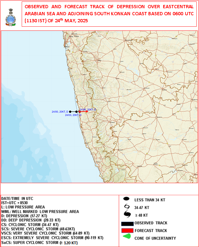
Observed and Forecast Track for Depression Over Arabian Sea
૨૪-૦૫-૨૦૨૫ 0600UTC (11.30 am. IST)
અરબી સમુદ્ર પર સર્જાયેલ ડિપ્રેશન માટે લીકેશન અને ટ્રેક ની આગાહી
-
Current Synoptic Conditions & Expected Weather Features
Date: 24 May 2025
The Depression over East Central Arabian Sea and adjoining south Konkan coast moved slowly eastward with a speed of 6 kmph during past 3 hours and lay centered at 0830 Hrs IST of today, the 24th May 2025 over the same region close to south Konkan coast near latitude 17.20 N & longitude 73.20 E, about 30 km north-northwest of Ratnagiri and 70 km south of Dapoli.
It is likely to continue to move nearly eastwards and cross south Konkan coast between Ratnagiri and Dapoli as a depression by noon of today, the 24th May 2025.
-
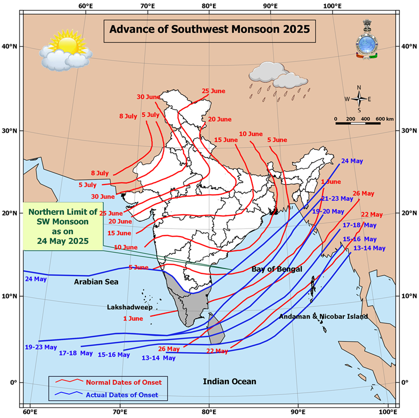
Southwest Monsoon Progress:
The Southwest Monsoon has further advanced into:
-
Remaining parts of south Arabian Sea
-
Parts of West central and East Central Arabian Sea
-
Entire Lakshadweep area, Kerala, and Mahe
-
Some parts of Karnataka
-
Remaining parts of Maldives and Comorin area
-
Many parts of Tamil Nadu
-
Remaining areas of southwest and eastcentral Bay of Bengal
-
Parts of West Central and North Bay of Bengal
-
Some parts of Mizoram
With this, the Southwest Monsoon has officially set in over Kerala today, 24th May 2025, which is ahead of its normal onset date of 1st June.
Northern Limit of Monsoon (NLM):
As of today, the NLM passes through the following coordinates and locations:
13°N/55°E – 13°N/60°E – 13.5°N/65°E – 15°N/70°E – Karwar – Shimoga – Dharmapuri – Chennai – 15°N/83°E – 18°N/87°E – Saiha – 25°N/96°E – 27°N/98°E
Outlook for Monsoon Advancement (Next 2–3 Days):
Conditions are favorable for further advancement of the Southwest Monsoon into:
-
More parts of the central Arabian Sea
-
Entire Goa
-
Some parts of Maharashtra and Andhra Pradesh
-
Additional areas of Karnataka and Tamil Nadu
-
More regions of West Central and North Bay of Bengal
-
Additional parts of the northeastern states
-
Some areas of Sub-Himalayan West Bengal and Sikkim
Trough Details:
-
A trough is currently extending from the the cyclonic circulation associated with the Depression over the South Konkan coast to south Madhya Maharashtra, south Marathwada, and north Telangana
-
This trough lies between 1.5 km and 3.1 km above mean sea level.
Low-Pressure Development Watch:
-
A new low-pressure area is likely to form over the West Central and adjoining north Bay of Bengal around 27th May.
-
Forecast for Gujarat, Saurashtra & Kutch (Up to 28th May 2025)
️ Wind Patterns:
-
Mainly Winds from West and Southwest and at times Variable winds.
-
Wind Speed: 15–20 km/h; gusts up to 20–30 km/h.
Very high gusts during thunder activity exceeding 50 km/hour
️ Sky Conditions:
-
Partly cloudy skies at times increased cloud cover.
️ Pre-Monsoon Activity:
-
Isolated to scattered rain expected over Saurashtra, Kutch & Gujarat region during 24th–28th May.
️
દક્ષિણ પશ્ચિમ ચોમાસું કેરળ અને કર્ણાટકના કેટલાક ભાગોમાં પ્રવેશી ગયું – દક્ષિણ કોકણ તટ પરનું ડિપ્રેશન પૂર્વ દિશામાં જમીન તરફ ખસી રહ્યું છે
️
️
વર્તમાન સિનોપ્ટિક સ્થિતિઓ અને અપેક્ષિત હવામાન લક્ષણો
તારીખ: 24 મે 2025
અરબ સાગરમાં ડિપ્રેશનની સ્થિતિ:
પૂર્વમધ્ય અરબ સાગર અને તે સાથે સંલગ્ન દક્ષિણ કોકણ તટ પર સર્જાયેલી ડિપ્રેશન છેલ્લા 3 કલાકમાં અંદાજે 6 કિમી પ્રતિ કલાકની ગતિએ ધીમે ધીમે પૂર્વ દિશામાં ખસેલી છે.
આજના 24 મે 2025ના રોજ ભારતીય માનક સમય મુજબ સવારે 8:30 વાગ્યે આ ડિપ્રેશન 17.2° ઉ.અ. અક્ષાંશ અને 73.2° પૂ.દે. રેખાંશ નજીક, દક્ષિણ કોકણ તટ પર રતનગિરિથી અંદાજે 30 કિમી ઉત્તર-ઉત્તરપશ્ચિમે અને દાપોલીથી 70 કિમી દક્ષિણમાં કેન્દ્રિત હતું.
આ સિસ્ટમની પૂર્વ દિશામાં ખસેલી રહી અને આજે બપોર સુધી રતનગિરિ અને દાપોલી વચ્ચે કોકણ તટને ડિપ્રેશન તરીકે પાર કરવાનો સંભવિત અંદાજ છે.
️ દક્ષિણ પશ્ચિમ ચોમાસાની પ્રગતિ:
દક્ષિણ પશ્ચિમ ચોમાસું હવે આગળ વધ્યું છે:
-
દક્ષિણ અરબ સાગરના બાકી રહેલા ભાગોમાં
-
પશ્ચિમમધ્ય અને પૂર્વમધ્ય અરબ સાગરના કેટલાક ભાગોમાં
-
આખા લક્ષદ્વીપ, કેરળ, અને મહે વિસ્તારમાં
-
કર્ણાટકના કેટલાક ભાગોમાં
-
માલદ્વીપ અને કુમોરીન વિસ્તારના બાકી ભાગોમાં
-
તમિલનાડુના ઘણા વિસ્તારોમાં
-
પશ્ચિમદક્ષિણ અને પૂર્વમધ્ય બંગાળની ખાડીના બાકી વિસ્તારોમાં
-
પશ્ચિમમધ્ય અને ઉત્તર બંગાળની ખાડીના કેટલાક ભાગોમાં
-
મિઝોરમના કેટલાક ભાગોમાં
આ સાથે, દક્ષિણ પશ્ચિમ ચોમાસું આજના રોજ, એટલે કે 24 મે 2025ના રોજ કેરળ પર સત્તાવાર રીતે પ્રવેશી ગયું છે, જે તેનું સામાન્ય આગમન દિવસ 1 જૂન કરતાં પહેલા છે.
ચોમાસાની ઉત્તરી સીમા (Northern Limit of Monsoon – NLM):
આજના રોજ ચોમાસાની ઉત્તરી સીમા નીચે દર્શાવેલી સ્થાનરેખાઓ અને સ્થળોથી પસાર થાય છે:
13°N/55°E – 13°N/60°E – 13.5°N/65°E – 15°N/70°E – કરવાર – શિમોગા – ધર્મપુરી – ચેન્નાઈ – 15°N/83°E – 18°N/87°E – સાઇહા – 25°N/96°E – 27°N/98°E
આગામી 2-3 દિવસ માટે ચોમાસાની આગળ વધવાની શક્યતા:
અગામી 2-3 દિવસોમાં દક્ષિણ પશ્ચિમ ચોમાસું આગળ વધવાની અનુકૂળ પરિસ્થિતિઓ નોંધાઈ રહી છે. ચોમાસું આગળ વધી શકે છે:
-
મધ્ય અરબ સાગરના વધુ વિસ્તારોમાં
-
આખા ગોવા વિસ્તારમાં
-
મહારાષ્ટ્ર અને આંધ્ર પ્રદેશના કેટલાક વિસ્તારોમાં
-
કર્ણાટક અને તમિલનાડુના વધુ વિસ્તારોમાં
-
પશ્ચિમમધ્ય અને ઉત્તર બંગાળની ખાડીના વધુ વિસ્તારોમાં
-
ઉત્તરપૂર્વ ભારતના વધારાના ભાગોમાં
-
સબ-હિમાલયન પશ્ચિમ બંગાળ અને સિક્કિમના કેટલાક ભાગોમાં
️ ત્રફ રેખાની વિગતો:
ડિપ્રેશન ડિપ્રેસન આનુસંગિક યુએસી દક્ષિણ કોકણ તટથી લઈને દક્ષિણ મધ્ય મહારાષ્ટ્ર, દક્ષિણ મરાઠવાડા અને ઉત્તર તેલંગાણા સુધી એક ત્રફ રેખા સર્જાઈ રહી છે. આ ત્રફ રેખા સમુદ્ર સપાટીથી 1.5 કિમીથી 3.1 કિમીની ઊંચાઈએ આવેલ છે.
ન્યુનતમ લો પ્રેસર વિસ્તાર પર નજર:
એક નવું લો પ્રેસર ક્ષેત્ર 27 મે આસપાસ મધ્ય પશ્ચિમ અને સંલગ્ન ઉત્તર બંગાળની ખાડીમાં વિકસી શકે છે.
ગુજરાત, સૌરાષ્ટ્ર અને કચ્છ માટે આગાહી (૨૮ મે ૨૦૨૫ સુધી)
પવનની દિશા અને ઝડપ:
-
મુખ્યત્વે પશ્ચિમ અને દક્ષિણપશ્ચિમ દિશાના પવન, ક્યારેક પવનની દિશામાં ફેરફાર.
-
પવનની ઝડપ ૧૫-૨૦ કિમી/કલાક, ત્યારે-ત્યારે ૨૦-૩૦ કિમી/કલાક સુધી ના ઝટકા ના પવનો.
- ગાજ વીજ સમયે અચાનક પવન સ્પીડ વધે અને ફરતા પવનો ની શક્યતા.
આકાશની સ્થિતિ:
-
ક્યારેક છુટા છવાયા વાદળ અને ક્યારેક આકાશ ઘેરાય.
પૂર્વ મોનસૂન પ્રવૃત્તિ:
-
૨4 થી ૨૮ મે દરમિયાન સૌરાષ્ટ્ર, કચ્છ અને ગુજરાતમાં સીમિત વિસ્તાર થી છુટા છવાયા વિસ્તાર માં પ્રિમોન્સૂન એક્ટિવિટી.
-
⚠️ Advisory
Caution: Please refer/rely on IMD/RSMC Bulletins/Advisories for Storms & Weather related matter.
સાવચેતી: સ્ટોર્મ કે હવામાન અંગે ની માહિતી માટે ભારતીય હવામાન ખાતા/ગવર્મેન્ટ ના બુલેટીન/સુચના પર નિર્ભર રહેવું.
Read Comment Policy – કમેન્ટ માટે માર્ગદર્શન વાંચો
How To Upload Profile Picture For WordPress – વર્ડપ્રેસ માં પ્રોફાઈલ પિક્ચર કેમ રાખવું
BAAKI Forecast In Akila Daily Dated 24th May 2025
BAAKI Forecast In Sanj Samachar Daily Dated 24th May 2025
તારીખ 30 મે 2025 આજની પરિસ્થિતિ ભારતીય હવામાન વિભાગ અનુસાર મીડ ડે બુલેટિન ❖ નૈઋત્ય ના ચોમાસાની રેખા 17.0°N/55°E, 17.5°N/60°E, 18°N/65°E, 18.5°N/70°E, મુંબઈ, અહિલ્યાનગર, આદિલાબાદ, ભવાનીપટના, પુરી, સેન્ડહેડ આઇલેન્ડ, 23.5°N/89.5°E, બલુરઘાટ અને 30°N/85°E માંથી પસાર થાય છે. ❖ બાંગ્લાદેશ પરનું ડિપ્રેશન છેલ્લા 6 કલાક દરમિયાન 18 કિમી પ્રતિ કલાકની ઝડપે ઉત્તર-ઉત્તરપૂર્વ તરફ આગળ વધ્યું અને આજે 30 મે 2025 ના રોજ ભારતીય સમય મુજબ સવારે 08:30 કલાકે બાંગ્લાદેશ પર 24.4°N અક્ષાંશ અને 89.6°E રેખાંશ નજીક, ટાંગૈલ (બાંગ્લાદેશ) થી લગભગ 40 કિમી પશ્ચિમ-ઉત્તરપશ્ચિમ, ઢાકા (બાંગ્લાદેશ) થી 110 કિમી ઉત્તરપશ્ચિમ, બહેરામપુર (ભારત) થી 140 કિમી ઉત્તર અને શિલોંગ (ભારત) થી 260 કિમી… Read more »
What is the Bharat Forecast System (BFS)? The Bharat Forecast System (BFS) is a short-range deterministic weather prediction model developed and run by IMD and IITM (Indian Institute of Tropical Meteorology). Key Features of IMD’s BFS: Full form: Bharat Forecast System Time Range: Short-range forecast — up to 3 days (72 hours) Resolution: High-resolution (~6 km grid scale) Output: Rainfall, wind, temperature, and other weather parameters Based on: Dynamical core similar to NCMRWF’s Unified Model or customized version of GFS/WRF Purpose: Operational weather forecasts for India with better regional accuracy IMD (ભારત હવામાન વિભાગ) દ્વારા વપરાતા BFS નો અર્થ છે… Read more »
BFS charts for India and Gujarat have been added in Menu
BFS ચાર્ટ્સ ઇન્ડિયા એન્ડ ગુજરાત માટે મેનુ માં સામેલ કરેલ છે.
4 week charts have been updated.
4 અઠવાડિયા ના ચાર્ટ્સ અપડેટ થયા છે.
Wah Thank You Sir… Jay Shree Radhe Krishna Ji….
Bsf insted of bfs in main manu
Edited
ane jovanu kai rite amo kai khabar padti nahti bfs kya lakhelu avtu nathi sar
App ma Menu ma Weather charts click karo etle dekhashe BFS and tene click karo
Aavu khulse
BFS click karo etle agad nu batavashe
ભારતમાં ચોમાસાની પ્રગતિ હવે શુષ્ક હવાના પ્રવેશને કારણે અટકી ગઈ છે. ભારતના પશ્ચિમ ભાગમાં વરસાદી પ્રવૃત્તિઓ/ઊંડા વાદળોમાં ખૂબ જ સ્પષ્ટ ઘટાડો થયો છે. શુષ્ક હવા અહીં રહેવા માટે હોવાથી ઓછામાં ઓછા 10 જૂન સુધી કોઈ મજબૂત ચોમાસાની પ્રગતિ અશક્ય છે.
Havaman janavo
Chomasa ne vaar chhe
સર તમે જવાબ આપ્યો કે 10 દિવસ ચોમાસુ સૌરાષ્ટ્ર માં આવે તેવું લાગતું નથી પરંતુ આ દિવસો માં પ્રીમોન્સુન એક્ટિવિટી થાય
yes
Chomasu weak padyu che hamna thoda diwas agal nai vadhe bhej vagar na sukka pawano ne lidhe. Chomasu apda normal time par j aavse. 12th June pachi chomasu active thay evu lagi rahyu che.. tya sudhi kaij nathi.
2,3,4 thunder activity?
Thoda chances che simit vistaro ma thunder activity na baki kai khaas nathi
Saheb gfs ane ventusky banne modal ma 12 13 tarikhe bob ma bhuvneswar pase low btave che te Ketla tka ganvu
Dar roj jovu
Sir have to ecmwf pan aaje bapor ni apdet ma batave che
Shu batavey chhe ?
Bob ma low btave che ecmwf ma
Saru toe aaj thi rakholu rakho dar roj !
Haji bahu dur ni vaat che 12 13 tarikh. Dar roj badlaya karse etle joya rakhvu..
Aa cola to first time joi 1979 nu lai aaya.
Hello Sir,, Aaje News Vala em k 6 k Gujrat upar 2 systerm sakriya 6 to e kay system ni vat kare 6?
System sabd khoti ritey vaparay chhe.
Normally Majboot UAC ke Low ke tenathi vadhu kai hoy tene System kahi ye chhiye.
Haal be Paribad ni vaat karta hoy em samjo.
News vala na Samachar kyarek vaasi hoy !
Ahi IMD nu Mid-Day Bulletin dar roj Gujarati ma aapel hoy chhe comment ma chotadel hoy.
Te vancho etle badha Paribado India na hoy. Temathi Gujarat ane najik na Paribado jova.
Thanks sir
Sir Aa BFS jota evu lage che ke apde have ECMWF ane GFS ni lagbhag jarur j nai pade jovani Good work From Forecast Department.
Tamne su lage che sir?
Compare karo etle khyal aavey
તારીખ 29 મે 2025 આજની પરિસ્થિતિ ભારતીય હવામાન વિભાગ અનુસાર મીડ ડે બુલેટિન ❖ નૈઋત્ય નું ચોમાસુ આજે 29 મે 2025 ના રોજ છત્તીસગઢ અને ઓડિશાના કેટલાક ભાગો, ઉત્તર બંગાળની ખાડીના કેટલાક ભાગો, પૂર્વોત્તર રાજ્યોના બાકીના ભાગો અને સબ-હિમાલયી પશ્ચિમ બંગાળના કેટલાક ભાગો અને સમગ્ર સિક્કિમમાં આગળ વધ્યું છે. ❖ નૈઋત્ય ના ચોમાસાની રેખા 17.0°N/55°E, 17.5°N/60°E, 18°N/65°E, 18.5°N/70°E, મુંબઈ, અહિલ્યાનગર, આદિલાબાદ, ભવાનીપટના, પુરી, સેન્ડહેડ આઇલેન્ડ, 23.5°N/89.5°E, બાલુરઘાટ, 30°N/85°E માંથી પસાર થાય છે. ❖ નૈઋત્ય નું ચોમાસું આગામી 1-2 દિવસ દરમિયાન પશ્ચિમ બંગાળ અને બિહારના કેટલાક ભાગોમાં નૈઋત્ય નું ચોમાસું વધુ આગળ વધવા માટે પરિસ્થિતિઓ અનુકૂળ છે. ❖ પશ્ચિમ બંગાળ-બાંગ્લાદેશ દરિયાકાંઠે… Read more »
IMD e Short range model ma BFS Na charts add Kari didha che. E gujarat weather ma nava ramkada tarike add karso?.
Yes.
અશોકભાઈ સૌરાષ્ટ્ર મા ચોમાસા નુ આગમન માટે 20 જુન ની આસપાસ ગણતરી રાખી શકાય?
Aavata 10 divas ma khas chomasu agad chaley evu nathi lagatu Saurashtra maate.
10 જૂન સુધી કાઇ વિશેષ લાગતું નહિ 4 જૂન ના દિવસે કદાચ થોડા ભગો માં થશે વરસાદ બાકી ક્યાંક ક્યાંક છુંટા છવાયા વરસાદ વગર કાઇ નહિ એટલે આપણે ચોમાસુ ટાઈમે જ આવશે …નોર્મલ તારીખ 21 જૂન છે એટલે કદાચ 15 જૂન પછી આગળ વધશે એટલે એ તારીખ આસપાસ ગુજરાત માં આવશે ચોમાસુ એવું હાલ તો બધા મોડેલ જોતા લાગે છે
Sir daily rainfall open nti tatu
Fakt Daily Rainfall hatu.
Atyre 12 vagya sudhi nu update thayel chhe.
Sir Temperature na chart update nathi thata.. 25 May na batave che.. Check karjo..
IMD ye update nathi karel.
Jay mataji sir…gairatre khub saro varsad pdyo 2 inch hse…aaje bhu divas psi mast thandak thai 6e atmosphere ma….
Vadodara ma 5 thi 7.30 sudhi ma light to moderate rain. Vacche vache vijdi na kadaka thaya jenathi rain intensity vadh ghat thati. Now it’s cool in vadodara.
May mahino atlo cool bahu ochu joyo che. Always hot and humid hoy che. Taukte time e atlo temperature down thayo hato.
Bhai aa vakhate weather ma bahu uncertainty Thai gai che. Unada jevu aa vakhate lagyuj nathi May month ma. May month maj 2 thi 3 vaar mavtha Thai Gaya. Mumbai ma pan 15 diwas vehlu chomasu aavi gayu ane tyaj atki gayu che have agal chalvama laambo time lagse.. Generally May month ma 44 to 45 degree gharmi rehti hoy che pan aa vakhate atyare 34 to 35 degree chale che.
Jsk Bhai, Amari side to pashu pakshi manushya ne Hafro chade evi garmi thai che!!!!!
Amare bharuch ma pn 5 thi 6 darmayan varsad pdyo
Ahmedabad Dholka ma 3 vagya vavajoda jode madhyam varsad
Vadodara ma savare 5 thi 6 ma hadvi gajbij sathe normal varsad.
Vadodara ma atyare vijli na kadaka bhadaka sathe pawan sathe atibhare varsad chalu. Extremely heavy rains with thunderstorms
2:30 3 vagya thi gajvij ane pavan sathe hdvo mdhyam dhodhmar evo varsad….atyare lgbhg hve puro thvama hoy am lage che….but 1k pchi 1k spell aave evi rite vrse che… northwest ane north baju thi aave che vaddo ane vrsta jay che
Jay mataji sir… Last 20 minit thi bhayankar vaijdi na kadaka bhadaka sathe varsad varsi rhyo….gajvij bhu j bhayanakar 6e atom bomb futi rhya 6e…
Jay mataji sir…aaje farithi Amara thi north ma dhimi dhimi vijdina chamakara chalu thaya 6e.. varsad nthi…
Namste Saheb danta Panthak ma Dhodhmar varsad chalu chhe 30 minut thi
Chomasu haal Mumbai par avine sthir Thai gayu che ane WD na sukka pawano ne lidhe hamna 10 thi 15 diwas chomasu agal nai vadhe etle apde haji chomasa mate laambi raah Jovi padse.
Gujarat par Monsoon ni je normal date chhe te rite j aavshe. Maate 15-25 June vachche.
Sachi vaat che. Mara anumaan mujab 12th June pachi chomasu active thay evu lagi rahyu che tya sudhi to kai dekhatu nathi.
Re fueling thai ne aave e saru……Kaidak Bhaidak ma kapasiya helmet na utare…
તારીખ 28 મે 2025 આજની પરિસ્થિતિ ભારતીય હવામાન વિભાગ અનુસાર મીડ ડે બુલેટિન ❖ નૈઋત્ય નું ચોમાસુ આજે 28 મે 2025 ના રોજ મહારાષ્ટ્રના કેટલાક ભાગો, કર્ણાટકના બાકીના ભાગો, તેલંગાણાના મોટાભાગના ભાગો, આંધ્રપ્રદેશના બાકીના ભાગો, છત્તીસગઢ અને ઓડિશાના કેટલાક ભાગો, મધ્યપશ્ચિમ બંગાળની ખાડીના બાકીના ભાગોમાં આગળ વધ્યું છે. ❖ નૈઋત્ય ના ચોમાસાની રેખા 17.0°N/55°E, 17.5°N/60°E, 18°N/65°E, 18.5°N/70°E, મુંબઈ, અહિલ્યાનગર, આદિલાબાદ, દાંતેવાડા, રાયગડા, 19°N/86°E, 21°N/89°E, અગરતલા, ગોલપરા અને 28.5°N/89°Eમાંથી પસાર થાય છે. ❖ નૈઋત્ય નું ચોમાસું આગામી 2 દિવસ દરમિયાન ઉત્તરપૂર્વીય રાજ્યોના બાકીના ભાગો, છત્તીસગઢ અને ઓડિશાના કેટલાક ભાગો, પશ્ચિમ બંગાળ અને સિક્કિમના કેટલાક ભાગોમાં નૈઋત્ય નું ચોમાસાના વધુ આગળ વધવા… Read more »
Imd gfc 10 day chalva lagyu
સર હવે અઠવાડિયુ બીવાજેવુ નથી ને ઉનાળુ મોસમ પુર જોશમાં ચાલી રહી છે
Haal Chomasu pragati Saurashtra maate vaar chhe.
Pavan and Thunder activity nu dhyan rakhvu.
to sir cola nathi khultu to tema taklif revani chhe ke su?
COLA Load thava ma vaar lagey chhe. COLA ne badale ghana ramakada chhe.
Ok sir
♦️♦️ मानसून पूर्वानुमान IMD ने जारी किया दूसरा पूर्वानुमान ♦️जून में नहीं चलेगी हीट वेव, सामान्य से 108 फीसदी ज्यादा होगी बारिश, मौसम विभाग का दूसरा पूर्वानुमान भारत ने स्वदेशी भारत फोरकास्ट सिस्टम (BFS) लॉन्च किया है, जो मौसम की सटीक भविष्यवाणी करेगा। मौसम विभाग के अनुसार, जून में हीट वेव की आशंका नहीं है। नई दिल्ली: मौसम की एकदम सटीक भविष्यवाणी के लिए भारत ने सवदेशी भारत फोरकास्ट सिस्टम (BFS) लॉन्च कर दिया है। इसके जरिए मौसम की ट्रैकिंग भी शुरू हो गई है। आज इस नए सिस्टम के जरिए ही मौसम की भविष्यवाणी की जा रही है। इस… Read more »
મે મહિનાના અંત સુધીમાં પાકિસ્તાન અને અફઘાનિસ્તાન જેવા દેશોથી મોટી માત્રામાં સૂકી હવા (ભૂરા રંગની) અરબી સમુદ્ર અને ભારત તરફ ફૂંકાશે. જૂનની શરૂઆતમાં આ સૂકી હવા ભારતમાં પ્રવર્તવાની ધારણા છે, જે ~5 જૂન સુધી ચોમાસાની આગળ વધવામાં અવરોધ ઉભો કરશે.
અશોક ભાઈ જૂનાગઢ જિલ્લાના કેશોદ તાલુકાના આજૂબાજૂના ગામડામાં કેવી ક શક્યતા છે વરસાદ ની કે હવે ઓરવવા નૂ સાલૂ કરી દીયે
Je haal chale chhe tema koi fix location nu nakki na hoy.
Kheti karya je karvanu hoy te chalu rakhay.