Monsoon Expected To Progress Over Gujarat Region & Enter Saurashtra & Kutch Zone During Forecast Period 1st-8th July 2026
Advance of Southwest Monsoon 2026
Some conditions as per the IMD Bulletin:
- The Northern Limit of Monsoon (NLM) continues to pass through 20°N/60°E, 20°N/65°E, 20°N/70°E, Surat, Indore, Mandla, Daltonganj, Motihari and 28.3°N/83°E.
- Conditions are favorable for the further advance of the Southwest Monsoon into some more parts of the North Arabian Sea, Gujarat, Madhya Pradesh, remaining parts of Chhattisgarh, Jharkhand & Bihar, and parts of Uttar Pradesh & Uttarakhand during the next two days, and thereafter into some more parts of Madhya Pradesh, Uttar Pradesh, Uttarakhand, parts of Himachal Pradesh, Jammu & Kashmir, Ladakh, southeast Rajasthan and the remaining parts of Gujarat during the subsequent 2–3 days.
- The seasonal trough at mean sea level from Punjab to Bihar across Haryana and Uttar Pradesh persists.
- The trough extending from north-central Madhya Pradesh to the East-Central Arabian Sea across north Maharashtra persists and is now seen between 4.5 km and 5.8 km above mean sea level.
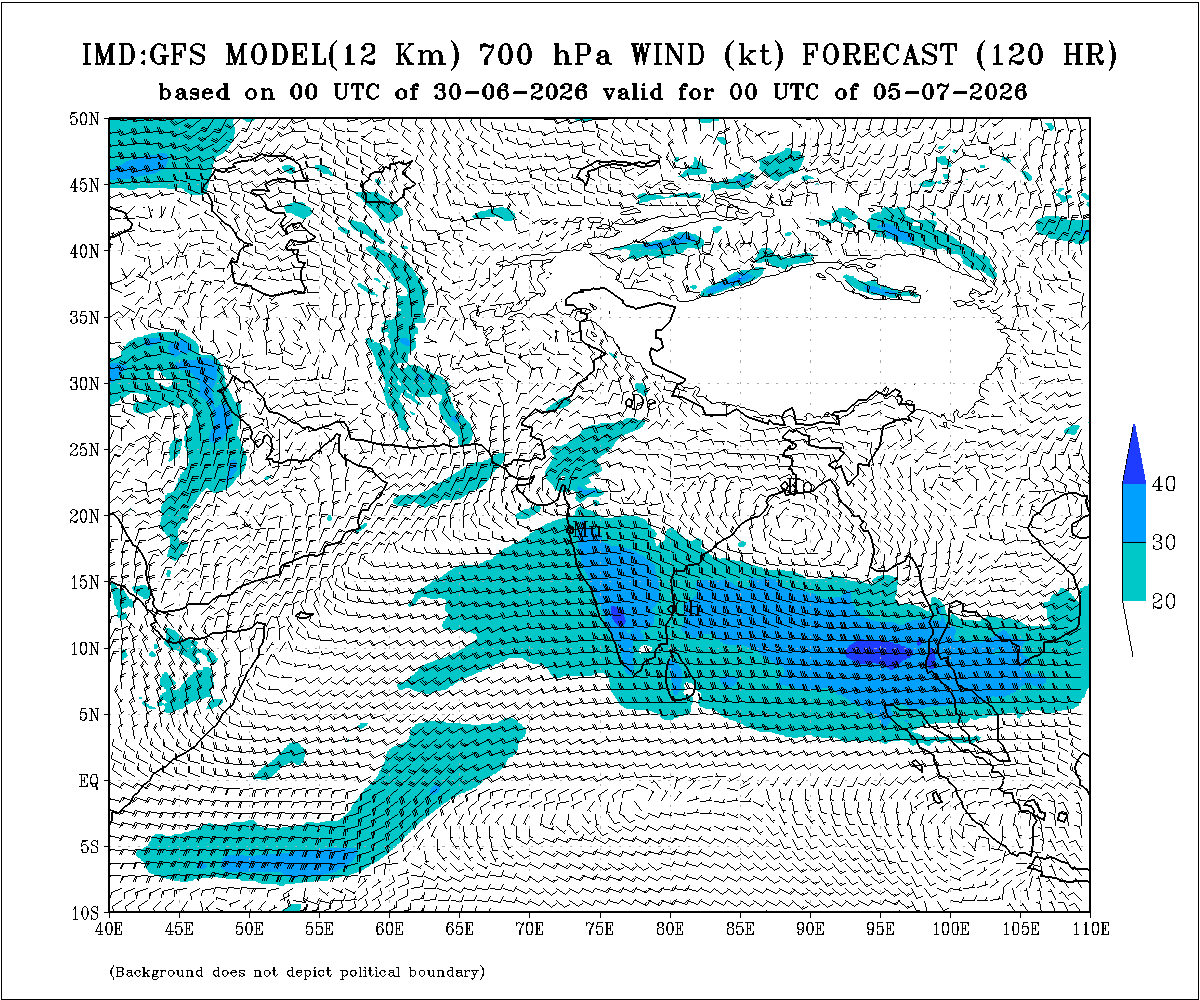
- An upper air cyclonic circulation (UAC) lies over north Odisha and neighborhood at 5.8 km above mean sea level.
- Another upper air cyclonic circulation lies over the north Bay of Bengal adjoining south Bangladesh between 1.5 km and 5.8 km above mean sea level.
- An upper air cyclonic circulation lies over Saurashtra at 3.1 km above mean sea level.
Expected Parameters:
Multiple Upper Air Cyclonic Circulations (UACs) are expected to develop, and at times may combine into a broader circulation. An east-west shear zone extending from Gujarat to West Bengal across Central India is also expected to develop. The distribution and intensity of rainfall will depend on the day-to-day evolution of these weather systems.
Weather Forecast for Saurashtra, Gujarat & Kutch (1st–8th July 2026)
Gujarat Region:
- Scattered to fairly widespread light to moderate rainfall on many days.
- Heavy to very heavy rainfall is likely on a few days.
- Thunderstorms, lightning and gusty winds of 40–50 kmph are likely at times.
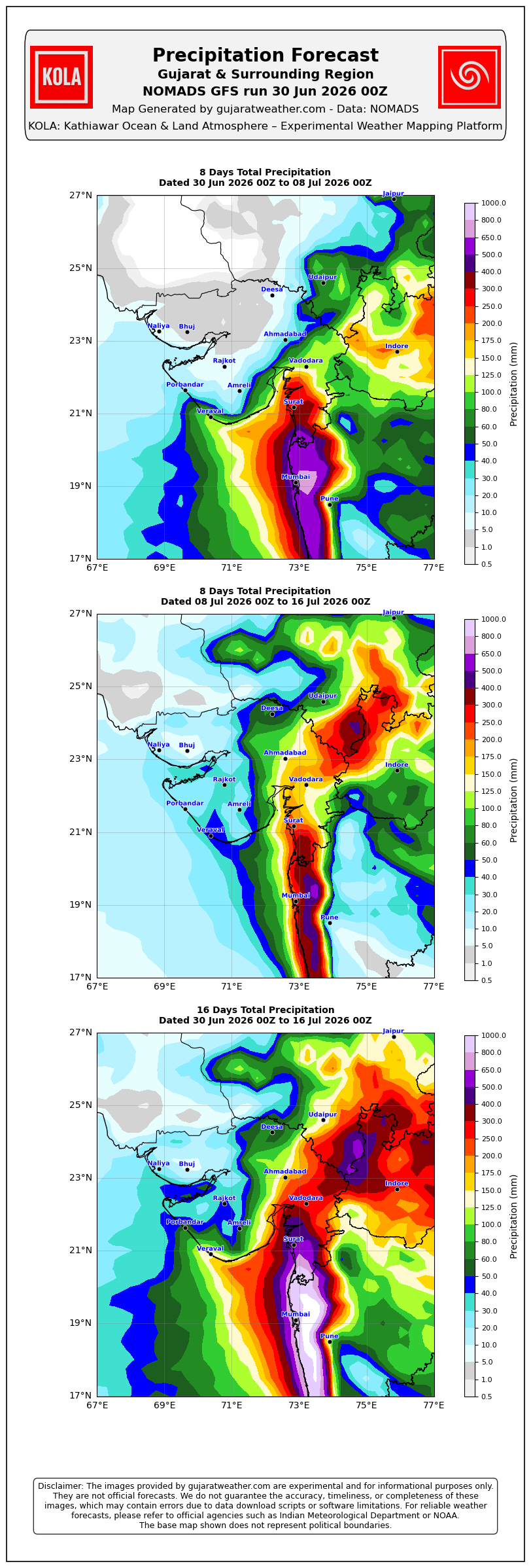
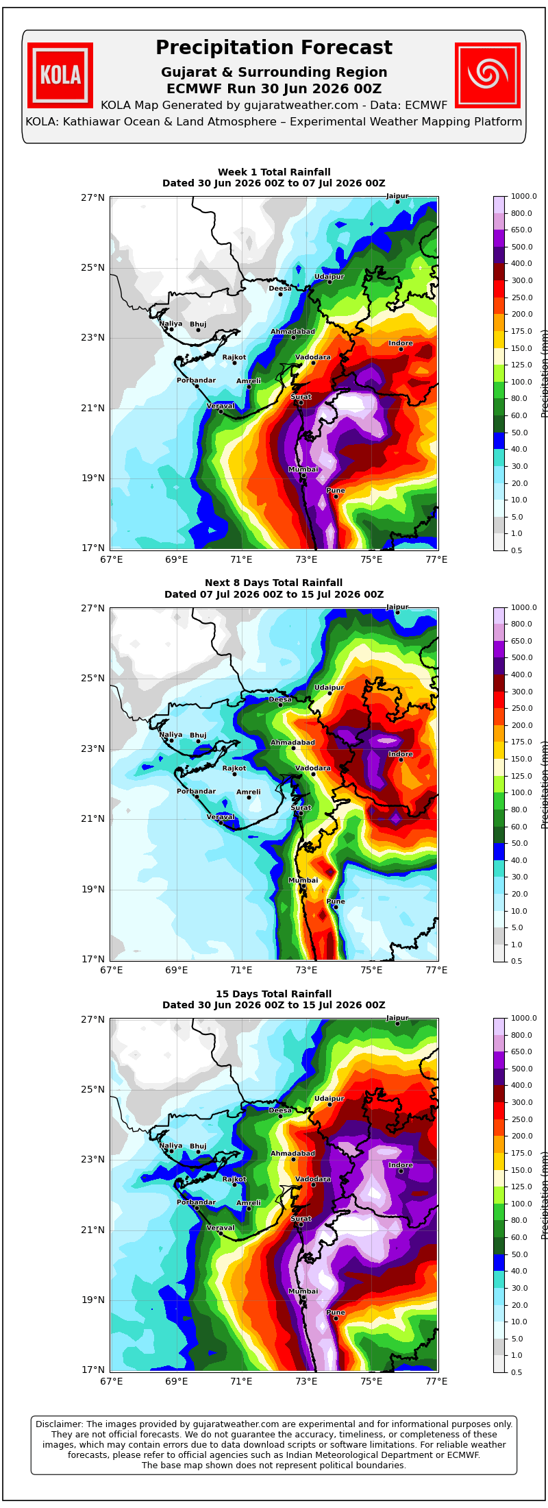
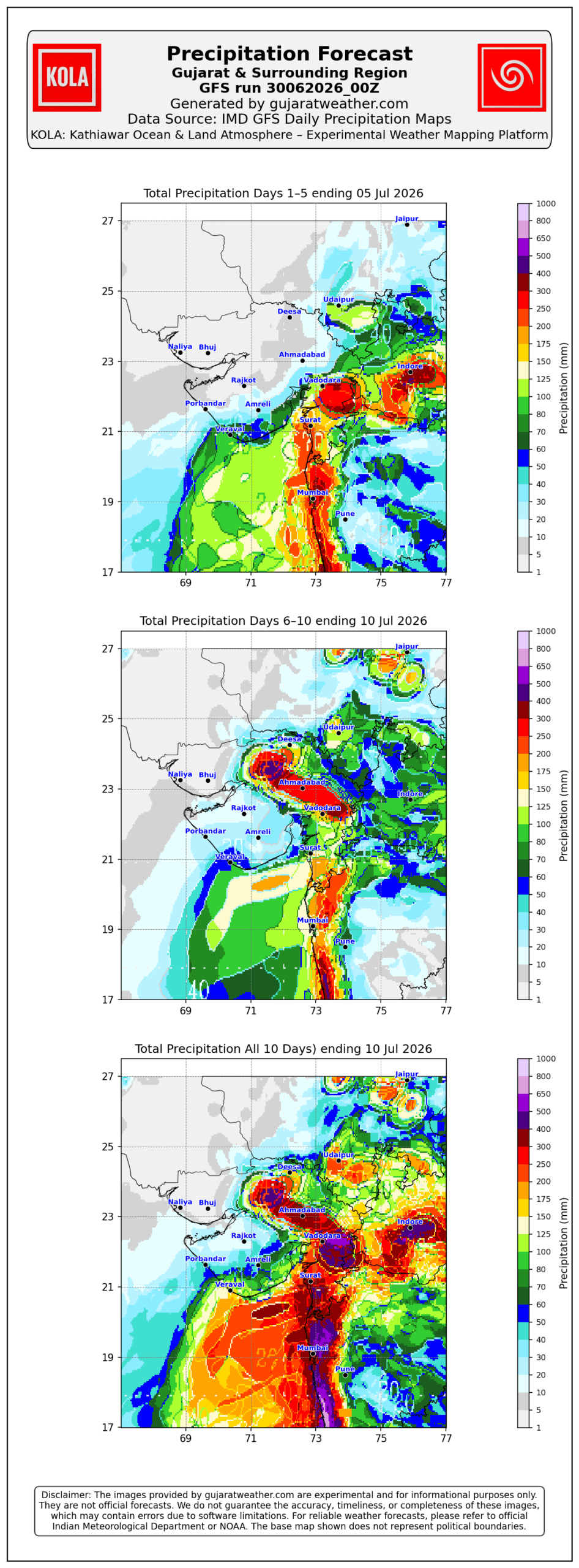
Expected Total Rainfall Distribution
- 10% of the area: Up to 25 mm
- 30% of the area: 25–75 mm
- 60% of the area: 75–150 mm, with isolated places exceeding 250 mm
Saurashtra & Kutch
- Scattered light to moderate rainfall during the period.
- Isolated heavy to very heavy rainfall is likely on a day or two
- Thunderstorms, lightning and gusty winds of 40–50 kmph are likely at times.
Expected Total Rainfall Distribution:
- 25% of the area: Up to 25 mm
- 50% of the area: 25–75 mm
- 25% of the area: Above 75 mm, with some centers exceeding 150 mm
Summary:
- The Southwest Monsoon is expected to make further progress across Gujarat Region and advance into Saurashtra & Kutch during the forecast period.
- Rainfall coverage and overall rainfall amounts are expected to increase across the entire State from 3rd July onward and will be significantly higher over Gujarat Region than over Saurashtra & Kutch.
Please refer to the maps given below for the supporting indications.
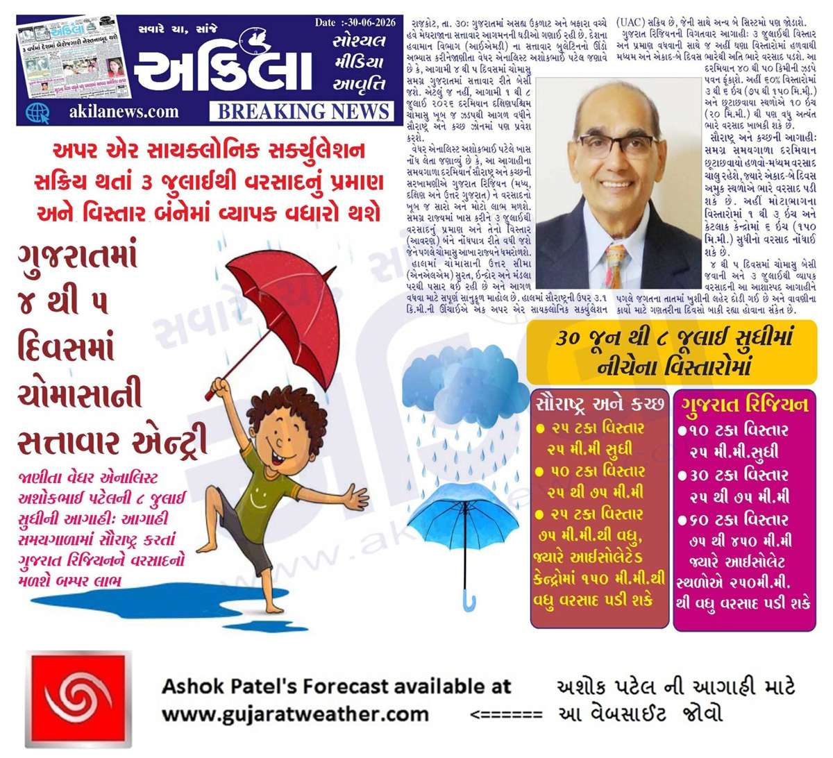
1 થી 8 જુલાઈ 2026 દરમિયાન ચોમાસું ગુજરાત રિજિયનમાં આગળ વધવાની તથા સૌરાષ્ટ્ર-કચ્છ ઝોનમાં પ્રવેશવાની શક્યતા
દક્ષિણપશ્ચિમ ચોમાસું 2026ની પ્રગતિ
IMD બુલેટિન મુજબ કેટલીક મુખ્ય પરિસ્થિતિઓ:
❖ ચોમાસાની ઉત્તર સીમા (Northern Limit of Monsoon – NLM) હાલ 20°N/60°E, 20°N/65°E, 20°N/70°E, સુરત, ઇન્દોર, મંડલા, ડાલ્ટનગંજ, મોતિહારી અને 28.3°N/83°E પરથી પસાર થાય છે.
❖ આગામી 2 દિવસ દરમિયાન દક્ષિણપશ્ચિમ ચોમાસું ઉત્તર અરબી સમુદ્રના વધુ ભાગો, ગુજરાત, મધ્ય પ્રદેશ, છત્તીસગઢના બાકીના ભાગો, ઝારખંડ, બિહાર તથા ઉત્તર પ્રદેશ અને ઉત્તરાખંડના કેટલાક ભાગોમાં આગળ વધવા માટે પરિસ્થિતિ અનુકૂળ છે. ત્યારબાદના 2–3 દિવસ દરમિયાન મધ્ય પ્રદેશ, ઉત્તર પ્રદેશ, ઉત્તરાખંડના વધુ ભાગો, હિમાચલ પ્રદેશ, જમ્મુ-કાશ્મીર, લદ્દાખ, દક્ષિણ-પૂર્વ રાજસ્થાન તથા ગુજરાતના બાકીના ભાગોમાં આગળ વધવાની શક્યતા છે.
❖ સમુદ્ર સપાટીએ પંજાબથી હરિયાણા અને ઉત્તર પ્રદેશ થઈ બિહાર સુધી વિસ્તરેલી મોસમી ટ્રફ યથાવત છે.
❖ ઉત્તર-મધ્ય મધ્ય પ્રદેશથી ઉત્તર મહારાષ્ટ્ર થઈ પૂર્વ-મધ્ય અરબી સમુદ્ર સુધી વિસ્તરેલી ટ્રફ યથાવત છે અને હાલમાં તે સરેરાશ સમુદ્ર સપાટીથી **4.5 થી 5.8 કિ.મી.**ની ઊંચાઈએ જોવા મળે છે.
❖ ઉત્તર ઓડિશા અને આસપાસના વિસ્તારમાં સરેરાશ સમુદ્ર સપાટીથી **5.8 કિ.મી.**ની ઊંચાઈએ અપર એર સાયક્લોનિક સર્ક્યુલેશન (UAC) આવેલું છે.
❖ દક્ષિણ બાંગ્લાદેશને અડીને આવેલા ઉત્તર બંગાળની ખાડી પર **1.5 થી 5.8 કિ.મી.**ની ઊંચાઈ વચ્ચે અન્ય એક અપર એર સાયક્લોનિક સર્ક્યુલેશન (UAC) આવેલું છે.
❖ સૌરાષ્ટ્ર ઉપર સરેરાશ સમુદ્ર સપાટીથી **3.1 કિ.મી.**ની ઊંચાઈએ અપર એર સાયક્લોનિક સર્ક્યુલેશન (UAC) આવેલું છે.
અપેક્ષિત પરિબળો:
એકથી વધુ અપર એર સાયક્લોનિક સર્ક્યુલેશન (UAC) વિકસે તેવી શક્યતા છે અને અમુક સમયે તે મળીને વિશાળ સર્ક્યુલેશનનું સ્વરૂપ ધારણ કરી શકે છે. ઉપરાંત મધ્ય ભારત પરથી પસાર થતો ગુજરાતથી પશ્ચિમ બંગાળ સુધીનો પૂર્વ-પશ્ચિમ શિયર ઝોન પણ વિકસે તેવી શક્યતા છે. વરસાદનું વિતરણ અને તેની તીવ્રતા આ હવામાન પરિબળોમાં દરરોજ થતા ફેરફારો પર આધારિત રહેશે.
સૌરાષ્ટ્ર, ગુજરાત અને કચ્છ માટે હવામાન આગાહી (1થી 8 જુલાઈ 2026)
ગુજરાત રિજિયન
- ઘણા દિવસો સુધી છૂટાછવાયા થી ઘણા વિસ્તારોમાં હળવાથી મધ્યમ વરસાદની શક્યતા.
- એકાદ-બે દિવસ ભારેથી અતિ ભારે વરસાદની શક્યતા.
- અમુક સમયે ગાજવીજ, વીજળી તથા 40–50 કિમી/કલાકની ઝડપે પવન ફૂંકાવાની શક્યતા.
અંદાજિત કુલ વરસાદનું વિતરણ:
- 10% વિસ્તાર: 25 મિ.મી. સુધી
- 30% વિસ્તાર: 25 થી 75 મિ.મી.
- 60% વિસ્તાર: 75 થી 150 મિ.મી., જ્યારે છૂટાછવાયા સ્થળોએ 250 મિ.મી.થી વધુ વરસાદ પડી શકે છે.
સૌરાષ્ટ્ર અને કચ્છ
- સમગ્ર સમયગાળા દરમિયાન છૂટાછવાયો હળવાથી મધ્યમ વરસાદની શક્યતા.
- એકાદ-બે દિવસે છૂટાછવાયા સ્થળોએ ભારેથી અતિ ભારે વરસાદની શક્યતા.
- અમુક સમયે ગાજવીજ, વીજળી તથા 40–50 કિમી/કલાકની ઝડપે પવન ફૂંકાવાની શક્યતા.
અંદાજિત કુલ વરસાદનું વિતરણ:
- 25% વિસ્તાર: 25 મિ.મી. સુધી
- 50% વિસ્તાર: 25 થી 75 મિ.મી.
- 25% વિસ્તાર: 75 મિ.મી.થી વધુ, જ્યારે કેટલાક કેન્દ્રોમાં 150 મિ.મી.થી વધુ વરસાદ પડી શકે છે.
સારાંશ:
- આગાહી સમયગાળા દરમિયાન દક્ષિણપશ્ચિમ ચોમાસું ગુજરાત રિજિયનમાં વધુ આગળ વધે તથા સૌરાષ્ટ્ર-કચ્છ ઝોનમાં પ્રગતિ કરશે.
- 3 જુલાઈથી સમગ્ર રાજ્યમાં વરસાદનું આવરણ તથા વરસાદની કુલ માત્રામાં વધારો થવાની શક્યતા છે, જોકે ગુજરાત રિજિયનમાં વરસાદનું આવરણ અને કુલ વરસાદ સૌરાષ્ટ્ર-કચ્છની સરખામણીએ નોંધપાત્ર રીતે વધુ રહેવાની સંભાવના છે.
આ અંગેના આધારરૂપ સંકેતો માટે ઉપર દર્શાવેલ વરસાદ ના નકશા આપેલ છે.
Caution: Please refer/rely on IMD/RSMC Bulletins/Advisories for Storms & Weather related matter.
સાવચેતી: સ્ટોર્મ કે હવામાન અંગે ની માહિતી માટે ભારતીય હવામાન ખાતા/ગવર્મેન્ટ ના બુલેટીન/સુચના પર નિર્ભર રહેવું.
Read Comment Policy – કમેન્ટ માટે માર્ગદર્શન વાંચો
How To Upload Profile Picture For WordPress – વર્ડપ્રેસ માં પ્રોફાઈલ પિક્ચર કેમ રાખવું
Forecast In Akila Daily Dated 30th June 2026
Forecast In Sanj Samachar Daily Dated 30th June 2026
અત્યારે અમારે સારામાં સારો વરસાદ ચાલુ છે
Monsoon Porbandar Vallabh Vidyanagar posigayu
Sir kola update kro
Saanje 7 Vagye thai jashe.
Sir aavnari sistam ma trek babte kay ferfar thay ke no thay fainali trek kiyare gnay
Low pressure track karta East West shear zone mahatva na ganay temaj bahodu circulation.
Sir amare varsadi vatavarn saru se pan varsadi nathi avto kyarek chanta pade
Khakhra hadmatya ૨”
Junagadh ma bhare varsad
1 inch thi vadhare thai gayo
તમે જૂનાગઢ તો નથી ને સર
Yes Savare Udan khatola Girnar Ropeway.
Atyare bijo round chalu thayo 1 vagya pachhi.
Varsad hoy to kejo kiya kiya se e
જેતલસર માં વાવણી લાયક વરસાદ
Vadodara ma raat thi vacche vacche zapta chalu che with stagnent thunderstorm
Junagadh ma Varsad saro chalu chhe 20 minutes thi.
Sarapdad kedi avse
આપણે ઓછા વરસાદમાં છીએ
10 date ma
તારીખ:- 1 જુલાઈ 2026 આજની પરિસ્થિતિ ભારતીય હવામાન વિભાગ અનુસાર મીડ-ડે બુલેટિન – નૈઋત્યનું ચોમાસું આજે ઉત્તર અરબી સમુદ્રના વધુ ભાગોમાં, ગુજરાતના વધુ વિસ્તારોમાં, સમગ્ર દમણ અને દીવ, મધ્ય પ્રદેશના વધુ ભાગોમાં, ઉત્તર પ્રદેશના વધુ ભાગોમાં, ઉત્તરાખંડના બાકીના વિસ્તારોમાં, હિમાચલ પ્રદેશ અને લદ્દાખના બાકીના વિસ્તારોમાં, સમગ્ર જમ્મુ અને કાશ્મીર તેમજ હરિયાણા અને પંજાબના કેટલાક ભાગોમાં આગળ વધ્યું છે. – ચોમાસાની ઉત્તર સીમા હાલ 22°N/60°E, 22°N/65°E, પોરબંદર, વલ્લભ વિદ્યાનગર, શાજાપુર, નૌગાંવ, મિર્જાપુર, આઝમગઢ, અયોધ્યા, બદાયूँ, મેરઠ, કર્ણાલ, ગુરદાસપુર અને 32.8°N/73°E પરથી પસાર થાય છે. – આગામી 2 દિવસ દરમિયાન નૈઋત્યનું ચોમાસું ઉત્તર અરબી સમુદ્રના વધુ ભાગોમાં, ગુજરાત, મધ્ય પ્રદેશ, ઉત્તર પ્રદેશ,… Read more »
માળિયા હાટીના તાલુકા તેમજ ગામડાઓ માં વાવણી લાયક સારો એવો વરસાદ થયો છે..
છેલ્લી અડધી કલાક થી વરસાદ શરૂ થયો છે 20 મિનિટ સારો આવ્યો અત્યારે ધીમી ધારે શરૂ છે,,
ધોરાજી તાલુકાના ઝાંઝમેર ગામે ધોધમાર વરસાદ
forcast mujab vatavaran ma fer far aaj thi. Upleta gramy vistar.
Aasha rakhi aagahi samay gada ma dil thi moj karave mehulo.
Sir,kola wait bov karave update mate thodi veli update na thay shake..? K te babat tmara hath ma nathi…
Aaje Kola update nathi.
Hu bahar chhu.
Somalia na jet pavano strong thaya chhe , system je banvani chhe e Gujarat saurashtra upar thi pasar thase ne saro varsad thase skymet weather mahesh paravat evu kahe chhe amuk jagya e poor jevi sthiti thase.
System na track ma ferfar thaya rakhe evu pan kahelu chhe .
Question: Sir somalia jet strong thay ena thi saurashtra kutch ne kai labh thay ?
Chomasu shakriya thay
જય શ્રી કૃષ્ણ સાહેબબોરવાવ ગીર (તાલાળા) માં આજે સવાર થી વાદળછાયું ફુલ બફારા વાળુ વાતાવરણ અને પવન ની ગતિ ધીમી અને ઉત્તર-પશ્ચિમ ની હતી. (જે આજે દિશા બદલી) બપોરે 12 વાગ્યા થી હળવો વરસાદ ચાલુ થયો સે ને પવન સાવ બંધ.
સર આઈકોન મોડલ છેલા ચાર પાંચ દિવસ થી સારો વરસાદ બતાવે છે તો જીફએસ ઈસીએફ કેમ ઓછો બતાવે છે કે પછી 2કે3તારીખ થી એપણ વધું બતાવશે
રાત્રે 1/30 કલાકે વાવણી જેવો કટોકટી વારો વરસાદ થયો
Sir mari comment nathi dekha ti email to barabar se
દેખાય ગઈ ભાઈ
Sir aaje amdavad no varo aavse k nai
Sar.700hpa ma shuka pavano se te kyare
Dur thase
Suka pavan ne hisabe sistam paschim saurastra baju wadhare andar aavti nathi
Bodeli rajpipla vache savar thi stagnant thunderstorm che vadodara city ghana vistaar ma jhapta jhupti
Amare bharuch ma modi rate saro varsad pdyo
સર વેરાવળ થિ ઉત્તર માં 10થિ 12 k.માં મારું લોકેશન છે વાદળ બંધાય પણ વરસાદ આવતો નથી જૂનાગઢ બાજુ વાવડ છે તો અમારા વિસ્તાર માં શું થશે આમ પણ છેલ્લા ધાણા દિવસ થિ કોસ્ટલ એરિયા માં આવતો નથી હવે તમે પ્રકાશ પાડજો
Finally Porbandar city ma aa Chomasa no Ratre 3 vaga thi savare 5 vaga sudhi Dhodhmar varsad pdyo Pavan sathe July 1st day Thi j jordar opening ekey models nata batavta avi gyo.
Hve Imd vara line khechi skse Chomasa ni.
Bs tyare mja mja party 🙂
Yes bhai 🙂
West saurashtra ane kutch japta jupti ni aasha rakhvani
સેટેલાઈટ અપડેટ કેમ નથી થતું
IMD ma koi technical problem hato.
જુનાગઢ ના ગ્રામ્ય વિસ્તારો મા ધીમીધારે વરસાદ ચાલુ છે.
સેટેલાઈટ અપડેટ નથી થતું
રાત્રીના 1 30 થી અત્યાર સવાર સુધી માં વાવણીલાયક વરસાદ થયો છે.
સર હજી આ વરસાદ આગળ હાલતો કેમ નથી જ્યા વાદળ સરુ થાય ત્યા વરસી જાય સે અમારે આજુ બાજુ મા 3વખત વરસાદ સે
sir aje muhrat thiy giu
Amare ratana 2 vagya thi dhimo dhimo chalu chhe
Sir amare to varsad ochho j lage chhe update jota vavni jevo thase k ny ?
Vadodara ma thanda pawano sathe madhyam varsad ni sharuat. Constant ek sarkho varsad padya kare che.
Chotila ma khali chhanta se
Sir Jamnagar mate kevu rese Aagahi samay ma
June ended.Visavadar rainfall 0%.Maney yaad chhe tya sudhi ma aavu first time thayu ke June end sudhima સમ ખાવા પૂરતું એક ઝાપટું પણ ન આવ્યું…
Anudeshak Umesh bhai……..Malhar Rag ma Sampreshan karvani try karo……Indra dev sathe.
vah saheb aaj Tamara javab vanchi ne moj padi gai
aam to ame jamnagar talika Vara 25 mm Vara chi pan tamari agahi Ane javab jota avu lage che ke 25 mm thi vardad vadhi jase
Atyre je Majbut Suka pavan fukai che e nabda pdse to all over saurashtra ma pn saro varsad pdi ske Atyare suka pavan Vilan che E Majbut che Models ane badhu jota West saurashtra mate Kathin hse lottery mujab round hse june ma 1 ke 2 divas zapta avya road bhina thai Eva baki Ghana varso baad Porbandar District 0 MM Rainfall june month ma.
સર આ અલનીનો નો આટલો બધો હાવ સુકામ ઊભો કરે છે બધા આ વખતે ?
Aapada chomasa pachhi El Nino majbut thay tevi shakyata chhe.
Sir ghani vakhat joyelu che varsad na batvta hoi to pan padi gayel che
Aja fere asha evij che ke kanudo varsad karse khara baki nay reva dye.
Baki hari ne devu hase to kalak nay thava dye.
Sarji apdat badal dhnyvad . Aa varse tamari aa paheli varsad ni apdat vachi ne khub saru lagiyu. Ane tame jiyare pan takavari ma apdat apo tiyare hu modal par thi andaj Karu ke ama apde Kiya Sai. Amari said thodi nirasa rahe aa raund ma tevu hal modalo parthi lagi rahyu che. Baki kudrat kare badha ne saro labh made Ane samgra gujrat ma vavni thay Jay. Aa Maru Taran saty ni naik che ne bapu,? Please ans
જય મુરલીધર સાહેબ
આ ચોમાસું ની આશાસ્પદ પહેલી અપડેટ્સ બદલ ખુબ ખુબ આભાર
પણ સર આગાહી સમય મા અમારો વિસ્તાર અને કચ્છ ને સુકા પવનોની અસર હોવા છતાં કેટલા આશાવાદી રહીએ
Rajkot Kangasiyali Ma De Dhana Dhan Varsad
ખુબ સરસ, સારા સમાચાર આભાર સાહેબ…