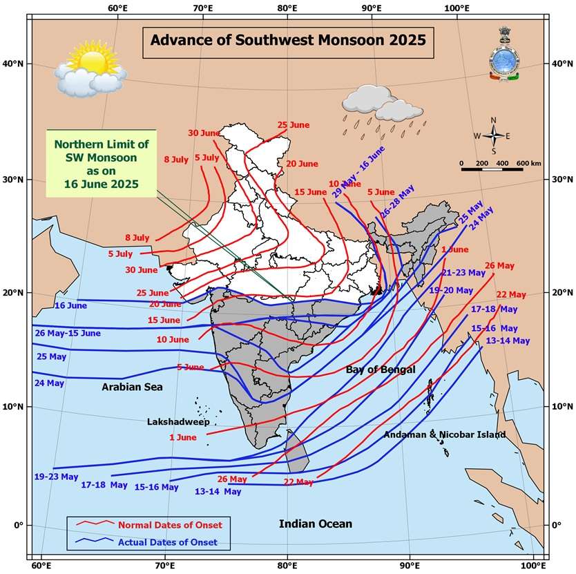
Southwest Monsoon Sets In Over Parts of Coastal Saurashtra and Parts of Gujarat Region Today 16th June 2025
દક્ષિણ પશ્ચિમ ચોમાસું કોસ્ટલ સૌરાષ્ટ્ર ના ભાગો તેમજ ગુજરાત રિજિયન ના ભાગો માં આજે તારીખ 16th June 2025 ના પ્રવેશ્યું
Current Weather Conditions – 16th June 2025
The Southwest Monsoon has further advanced into the following regions:
- Entire Konkan and Madhya Maharashtra
- Parts of Coastal Saurashtra and parts of Gujarat Region
- Southwest Madhya Pradesh
- Some more parts of Vidarbha, Chhattisgarh, Odisha
- Sub-Himalayan West Bengal & Sikkim (partial advancement)
Current Synoptic Conditions
Northern Limit of Monsoon (NLM)
As of 16th June 2025, the Northern Limit of Monsoon passes through:
20.0°N/60°E, 20.5°N/65°E, Veraval, Bhavnagar, Vadodara, Khargone, Amravati, Durg, Bargarh, Chandbali, Sandhead Island, 23.5°N/89.5°E, Balurghat, and 30.0°N/85.0°E
Monsoon Advancement Outlook
Favorable conditions are expected for further advancement of the Southwest Monsoon into:
- More parts of Gujarat and Madhya Pradesh
- Remaining parts of Vidarbha
- More parts of Chhattisgarh and Odisha
- Remaining parts of Sub-Himalayan West Bengal & Sikkim (within the next 24 hours)
- Parts of West Bengal, Jharkhand, Bihar, and East Uttar Pradesh (during the subsequent 2 days)
Synoptic Features
- An upper air cyclonic circulation lies over the Northwest Bay of Bengal and adjoining areas, tilting southwestward with height in the lower and middle tropospheric levels.
- Another cyclonic circulation is observed over South Gujarat and nearby regions in the middle tropospheric levels.
- Under its influence, a Low-Pressure Area is likely to form over the same region in the next 24 hours.
- It is expected to move north-northwestwards and become more marked in the following 24 hours.
Also refer to the forecast update dated 14th June 2025 for additional context
️
દક્ષિણ પશ્ચિમ ચોમાસું કોસ્ટલ સૌરાષ્ટ્ર ના ભાગો તેમજ ગુજરાત રિજિયન ના ભાગો માં આજે તારીખ 16th June 2025 ના પ્રવેશ્યું
️
તારીખ: 16મી જૂન 2025
વર્તમાન હવામાન સ્થિતિ – 16મી જૂન 2025
દક્ષિણ પશ્ચિમ ચોમાસું આગળ વધીને નીચેના વિસ્તારોમાં પ્રવેશી ગયું છે:
-
સમગ્ર કોંકણ અને મધ્ય મહારાષ્ટ્ર
-
કોસ્ટલ સૌરાષ્ટ્ર ના ભાગો તેમજ ગુજરાત રિજિયન ના ભાગો માં
-
દક્ષિણ પશ્ચિમ મધ્ય પ્રદેશ
-
વિદર્ભ, છત્તીસગઢ, ઓડિશાના કેટલાક વધુ ભાગો
-
સબ-હિમાલયન પશ્ચિમ બંગાળ અને સિક્કિમના કેટલાક ભાગો
ચોમાસાની ઉત્તરી સીમા (NLM)
16મી જૂન 2025ની સ્થિતિ મુજબ, ચોમાસાની ઉત્તર સીમા નીચેના સ્થળોમાંથી પસાર થાય છે:
20.0°N/60°E, 20.5°N/65°E, વેરાવળ, ભાવનગર, વડોદરા, ખંડવા, અમરાવતી, દુર્ગ, બરગઢ, ચાંદબલી, સેન્ડહેડ આઈલેન્ડ, 23.5°N/89.5°E, બાલુરઘાટ અને 30.0°N/85.0°E
ચોમાસું આગળ વધવાનો અંધાજ
ચોમાસું આગળ વધવા માટે પરિસ્થિતિ અનુકૂળ છે, અને તે નીચેના વિસ્તારોમાં આગળ વધી શકે છે:
-
ગુજરાત અને મધ્ય પ્રદેશના વધુ વિસ્તારો
-
વિદર્ભના બાકી રહેલા વિસ્તારો
-
છત્તીસગઢ અને ઓડિશાના વધુ વિસ્તારો
-
સબ-હિમાલયન પશ્ચિમ બંગાળ અને સિક્કિમના બાકી રહેલા વિસ્તારો (આગામી 24 કલાકમાં)
-
પશ્ચિમ બંગાળ, ઝારખંડ, બિહાર અને પૂર્વ ઉત્તર પ્રદેશના કેટલાક ભાગો (આગામી 2 દિવસોમાં)
વાતાવરણીય પરિબળો
-
એક UAC ઉત્તર પશ્ચિમ બંગાળની ખાડી અને આસપાસના વિસ્તારોમાં જોવા મળે છે, જે નીચલા અને મધ્યમ સ્તરે ઊંચાઈ પર દક્ષિણ પશ્ચિમ તરફ ઢળી રહી છે।
-
બીજું એક UAC દક્ષિણ ગુજરાત અને નજીકના વિસ્તારોમાં મધ્યમ સ્તરે પ્રવર્તી રહ્યું છે।
-
તેની અસર હેઠળ, આગામી 24 કલાકમાં લો પ્રેસર આ વિસ્તારમાં વિકસવાની શક્યતા છે।
-
આ સિસ્ટમ ઉત્તર-ઉત્તર પશ્ચિમ દિશામાં ખસે તેવી સંભાવના છે અને તે આગળ WMLP બની શકે છે (આગામી 24 કલાકમાં).
- વધુ માહિતી માટે 14મી જૂન 2025ની આગાહી અપડેટ પણ જુઓ.
-
-
⚠️ Advisory
Caution: Please refer/rely on IMD/RSMC Bulletins/Advisories for Storms & Weather related matter.
સાવચેતી: સ્ટોર્મ કે હવામાન અંગે ની માહિતી માટે ભારતીય હવામાન ખાતા/ગવર્મેન્ટ ના બુલેટીન/સુચના પર નિર્ભર રહેવું.
Read Comment Policy – કમેન્ટ માટે માર્ગદર્શન વાંચો
How To Upload Profile Picture For WordPress – વર્ડપ્રેસ માં પ્રોફાઈલ પિક્ચર કેમ રાખવું
Forecast In Akila Daily Dated 16th June 2025
Forecast In Sanj Samachar Daily Dated 16th June 2025
દક્ષિણ ગુજરાત અને તેના આસપાસના વિસ્તારો પર UAC ના પ્રભાવ હેઠળ, આજે ૧૭ જૂન ૨૦૨૫ ના રોજ ભારતીય સમય મુજબ સવારે ૦૫.૩૦ કલાકે ગુજરાત અને તેના આસપાસના વિસ્તારોમાં લો પ્રેશર રચાયુ છે. આગામી ૨૪ કલાક દરમિયાન આ સીસ્ટમ વધુ તીવ્ર બને અને ઉત્તર-ઉત્તરપશ્ચિમ તરફ આગળ વધે તેવી શક્યતા છે.
Sir rainfall data update krjo ne 10 sudhi na.
Savare
Cola kyathi jovay badhu farigsyu
COLA bandh thai gayu
Bhare kari ho
Vadodara ma pawan sathe dhimi dhare varsad padi rahyo che from South direction.
Amare atiyare jamnagar ma lagbhag 9.30 thi normal speed ma avya rakhe che ane have addhi kalak thi vijdi thay che gajvij normal
Kachh vara mitro tayar rahejo vajte gajte te baju aavi rahyu se maliya thi entry thahe
Chalu che bhai 30 minit thi
Dhodhmar varsad padi rahyo se 9 vagya thi ekdharo haju
ગાજવીજ કે પવન વગર સારો એવો વરસાદ ચાલુ, લગભગ 22:40 થી
સર મારી કોમેન્ટ દેખાતી કેમ નથી
સર અમારે આજે 8 થી 10.50 સુધી માં જોરદાર વરસાદ થયો વાવણી લાયક અને હજુ ધીમી ધારે ચાલુ છે
Dhodmar varsad chalu
10:30
Dhodmar varsad chalu
10:30pm
વાંકાનેર ના ગ્રામ્ય વિસ્તાર માં વાવણી લાયક વરસાદ થયો હજી ચાલુ છે
કેમ ધીમી ધારે જ વરસાદ આવે છે આપણા રાજકોટ માં સાહેબ મોટી સારણી ચડાવસે કે આમ જ હાલસે
જય મુરલીધર સાહેબ
દેવભૂમિ દ્વારકા જિલ્લામાં આ વખતે તમારા અંદાજ મુજબ કેવી શક્યતા છે વરસાદ ની
અમારે આજે વાવણી લાયક વરસાદ થઈ ગયો.
અમારે આજે વાવણીલાયક સારો વરસાદ
Welcome monsoon 2025
Ashok Sir and friends
Sir Satellite Image Jota Vadado Upr north Kora jai che to Nava bni ske ke Porbandar ane niche na vistaro ma Bhare varsad nu Sankat nathi hve ??
UAC ma alag alag level ma alag alag center hoy.
IMD GFS jota aevu lage 6e ke shavar shudhi ma saro varshad aavi jase
Su lge sir svar sudhima apda Rajkot no bedo parr thai jse…rate sui jai etle hmesha jm mota varsad ma thai em ?
Badhi baju vijadi thay chhe. Varasani Bahu dhimi chhe.
IMD GFS 12 UTC jovo.
Update nthi thyu
Sorry. You are right !
Ae kevi rite jovay
IMD GFS Precipitation 00 UTC page par jovo.
Page oopar 06 UTC 12 UTC 18 UTC lakhel chhe. tema 12 UTC click karo etle 12 UTC nu batavashe. Update thayel chhe ke nahi te jovu.
Update matlab time 12 UTC 16-06-2025 to 12 UTC 17th June 2025
Update nti sir
Update thay tyare jovu
Khub saro varsad pdyo gajvij sathe 7 vagya thi….khub pldya hu ne mari chokri bv mja pdi 🙂 atyare dhimo mdhyam jevo chalu che 🙂 Vaddo east to west jay che…..Welcome Monsoon 2025 🙂
Ashok bhai amne aa round ma labh madse kutchh ne ?
Koi pan System Kutch ne Salam maryaa vagar kyanthi jaay !
Dhanyavad saheb
sir aa sistam to North West chale che to kutch, Pachim saurashtra mate thodu vicharva jevu kevay to pan uac na panvno upar aadhar kevay joy 2 divas ma su thay che
sir atyare aa thunderstorm clowd saurashtra aakhu cover che pan
varsad ni savare khabar pade kya ketlo aape e
rajkot ma atyare mast dhimo varsad chalu che Ane nichala leval na richada jeva vadad north West thi south est baju Jay che
Sar Amara dhrol no varo avsah
મોન્સુન ની શરૂવાત માં જ ભૂકા બોલાવે હો બાકી……બીજો spell શરૂ થયો
Abhi to party suru hui hai dost. lyo labh…..amne kale labh madi jase evu lage che.
Yes ….valve bandh chalu bandh chalu kre che
Gaya varshe tame dhodhmar ni raah joi rahya hata ane aa varshe ame dhodhmar ni raah joi rahya chiyea..
Jay mataji sir….aaje pan sanje 4 vagya thi varsadi atmosphere 6e AEK hadvu zaptu aavyu tyarbad atare vijdi thai rhi 6e…
ગીર સાસણ ના ચિત્રોડ ગામ પાસે ના Gir Vanvasho રિસોર્ટ માં છેલ્લા ૧૮ કલાક થી સતત ધીમી ધારે કાચું સોનું વરસી રહ્યું છે… અને વાતાવરણ હજુ જામેલું જ છે.
વેલ કમ મોન્સુન 2025
સર આ રાઉન્ડ માં ગીર ના ગામડા માં માત્ર છાંટા જ આવ્યા વધારે વરસાદ ની શક્યતા રહેલી છે કે ?
સર જવાબ આપજો પ્લીઝ
Sir, aje amare ati bhare varsad padyo 11:30am thi 4:30pm sudhi 11+ inch varsad padyo..
10 liter ni dol salkay gay je niche thi upar sudhi ekj sapati sarkhi hati..haju madhyam salu j se..
૧૫ મિનિટ જોરદાર વરસાદ આવ્યો હાલ ધીમી ધારે ચાલુ
Dhoraji ma ajno varsad 1.5 Ench
સર અરવલ્લી મા આ શિસ્તમ નો લાભ મળશે?
દામનગર ગારિયાધાર ના બધા ગામોમાં અંદાજે 5 થી 10 ઇંચ વવરસાદ હજુ વરસાદ ચાલુ છે
Amre5.50
અમારે ધીમી ધારે ગાજવીજ સાથે ચાલુ છે
Sir wonderground ma kai samaj nathi padati mane Kai rite jovay thodi mahiti aapo possible hoy to
Select center click karo
Tamaru center select karo.
Niche Blue button click karo.
સર &મિત્રો અમારે વડીયા માં કાલ સાંજ નો સતત ધીમીધારે વરસાદ ચાલુ છે 24 કલાક ઉપર થઈ ગયા હજી એજ ધીમી ગતિએ ચાલુ છે,,આશરે 2 ઇંચ જેવો થયો હસે,,
Amare bharuch ma bhare pavan sate varsad pdi rhyoj
Ahmedabad Dholka ma 5 vagya thi
Hadvo thi medium varsad chalu
અમારે ગઢડા મા 5 ઈન્સ જેવો અંદાજે
અમારે ખૂબ ઘેરાયા પછી 20 મિનિટથી ધીમી ધારે વરસાદ ચાલુ થયો છે. હેપ્પી મોન્સૂન.
ગુરુજી પ્રણામ
16/6/25
આજનો વરસાદ
ઢસા વિસ્તાર
સવાર થી છાટાછુટી ઝાપટાં ધીમી ધારે બપોર પછી નેવાધારૂ સાંજે ધોધમાર ભારે વરસાદ હજુ શરૂ છે
આજુબાજુ ના ગામો મા પણ ભારે વરસાદ શરૂ છે
Amare 10 minit thai gajvi ane kdaka shathe thaimi dhare varsaad chalu
Chotila ma kadaka ne bhadaka sathe full varsad chalu se
અમારે ગાજવીજ સાથે ધીમી ધારે વરસાદ ચાલુ થયો છે…..રાત્રિ નાં ફૂલ વાલ ખુલશે કદાચ!!!ધીમો તો ધીમો હવે કપાસિયા બધા ઉગી જસે એટલે રાહત
Thanks, saheb
Rajkot City ma dhime dhime start thyo chhe varsad.
Bhatiya ma varshad chalu thyao lage chhe vavni jevu thay jase
Dhime dhime gati pakde chhe, laage chhe k rate varo kadhse.
Ashok Sir, Tamar vadi kuvadva valu khijadiya chhe tya k pachhi vankaner baju ek khijadiya chhe tya?
Nakarawadi, Pipalia, Khijadiya, Sanosara (Kuvadva)
Oh, achha Khijadiya mar mama nu gaam chhe aetle puchto
Hello sir and friends, 4 to 7 pm varsad e bhukka boliva didha, pani pani kari didhu
નવી અપડેટ આપવા બદલ આભાર સાહેબ,
અત્યારે પાંચ વાગ્યા પછી સારો વરસાદ પડયો
ખેતરોમાંથી પાણી બહાર નીકળી ગયા,
વાવણીલાયક વરસાદ પડ્યો.
Thank you sir for new update
Jay shree krishna sir aa round ma Derdi kumbhaji sultanpur devliya kukavav varshad vavni layak aavse sir please javab apjo