Southwest Monsoon Arrives Over Kerala & Parts of Karnataka – The Depression Over Coastal South Konkan Moving Eastwards Over Land
દક્ષિણ પશ્ચિમ ચોમાસું કેરળ અને કર્ણાટકના કેટલાક ભાગોમાં પ્રવેશી ગયું – દક્ષિણ કોકણ તટ પરનું ડિપ્રેશન પૂર્વ દિશામાં જમીન તરફ ખસી રહ્યું છે
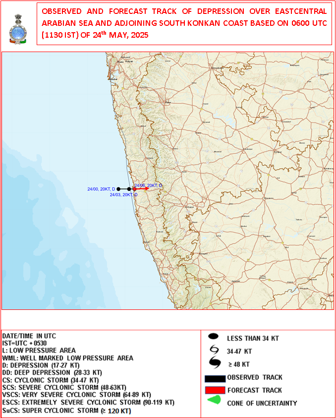
24-05-2025 0600 UTC (11.30 am. IST)
Observed and Forecast Track for Depression Over Arabian Sea
૨૪-૦૫-૨૦૨૫ 0600UTC (11.30 am. IST)
અરબી સમુદ્ર પર સર્જાયેલ ડિપ્રેશન માટે લીકેશન અને ટ્રેક ની આગાહી
-
Current Synoptic Conditions & Expected Weather Features
Date: 24 May 2025
The Depression over East Central Arabian Sea and adjoining south Konkan coast moved slowly eastward with a speed of 6 kmph during past 3 hours and lay centered at 0830 Hrs IST of today, the 24th May 2025 over the same region close to south Konkan coast near latitude 17.20 N & longitude 73.20 E, about 30 km north-northwest of Ratnagiri and 70 km south of Dapoli.
It is likely to continue to move nearly eastwards and cross south Konkan coast between Ratnagiri and Dapoli as a depression by noon of today, the 24th May 2025.
-
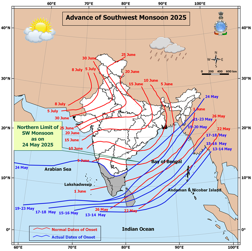
Southwest Monsoon Progress:
The Southwest Monsoon has further advanced into:
-
Remaining parts of south Arabian Sea
-
Parts of West central and East Central Arabian Sea
-
Entire Lakshadweep area, Kerala, and Mahe
-
Some parts of Karnataka
-
Remaining parts of Maldives and Comorin area
-
Many parts of Tamil Nadu
-
Remaining areas of southwest and eastcentral Bay of Bengal
-
Parts of West Central and North Bay of Bengal
-
Some parts of Mizoram
With this, the Southwest Monsoon has officially set in over Kerala today, 24th May 2025, which is ahead of its normal onset date of 1st June.
Northern Limit of Monsoon (NLM):
As of today, the NLM passes through the following coordinates and locations:
13°N/55°E – 13°N/60°E – 13.5°N/65°E – 15°N/70°E – Karwar – Shimoga – Dharmapuri – Chennai – 15°N/83°E – 18°N/87°E – Saiha – 25°N/96°E – 27°N/98°E
Outlook for Monsoon Advancement (Next 2–3 Days):
Conditions are favorable for further advancement of the Southwest Monsoon into:
-
More parts of the central Arabian Sea
-
Entire Goa
-
Some parts of Maharashtra and Andhra Pradesh
-
Additional areas of Karnataka and Tamil Nadu
-
More regions of West Central and North Bay of Bengal
-
Additional parts of the northeastern states
-
Some areas of Sub-Himalayan West Bengal and Sikkim
Trough Details:
-
A trough is currently extending from the the cyclonic circulation associated with the Depression over the South Konkan coast to south Madhya Maharashtra, south Marathwada, and north Telangana
-
This trough lies between 1.5 km and 3.1 km above mean sea level.
Low-Pressure Development Watch:
-
A new low-pressure area is likely to form over the West Central and adjoining north Bay of Bengal around 27th May.
-
Forecast for Gujarat, Saurashtra & Kutch (Up to 28th May 2025)
️ Wind Patterns:
-
Mainly Winds from West and Southwest and at times Variable winds.
-
Wind Speed: 15–20 km/h; gusts up to 20–30 km/h.
Very high gusts during thunder activity exceeding 50 km/hour
️ Sky Conditions:
-
Partly cloudy skies at times increased cloud cover.
️ Pre-Monsoon Activity:
-
Isolated to scattered rain expected over Saurashtra, Kutch & Gujarat region during 24th–28th May.
️
દક્ષિણ પશ્ચિમ ચોમાસું કેરળ અને કર્ણાટકના કેટલાક ભાગોમાં પ્રવેશી ગયું – દક્ષિણ કોકણ તટ પરનું ડિપ્રેશન પૂર્વ દિશામાં જમીન તરફ ખસી રહ્યું છે
️
️
વર્તમાન સિનોપ્ટિક સ્થિતિઓ અને અપેક્ષિત હવામાન લક્ષણો
તારીખ: 24 મે 2025
અરબ સાગરમાં ડિપ્રેશનની સ્થિતિ:
પૂર્વમધ્ય અરબ સાગર અને તે સાથે સંલગ્ન દક્ષિણ કોકણ તટ પર સર્જાયેલી ડિપ્રેશન છેલ્લા 3 કલાકમાં અંદાજે 6 કિમી પ્રતિ કલાકની ગતિએ ધીમે ધીમે પૂર્વ દિશામાં ખસેલી છે.
આજના 24 મે 2025ના રોજ ભારતીય માનક સમય મુજબ સવારે 8:30 વાગ્યે આ ડિપ્રેશન 17.2° ઉ.અ. અક્ષાંશ અને 73.2° પૂ.દે. રેખાંશ નજીક, દક્ષિણ કોકણ તટ પર રતનગિરિથી અંદાજે 30 કિમી ઉત્તર-ઉત્તરપશ્ચિમે અને દાપોલીથી 70 કિમી દક્ષિણમાં કેન્દ્રિત હતું.
આ સિસ્ટમની પૂર્વ દિશામાં ખસેલી રહી અને આજે બપોર સુધી રતનગિરિ અને દાપોલી વચ્ચે કોકણ તટને ડિપ્રેશન તરીકે પાર કરવાનો સંભવિત અંદાજ છે.
️ દક્ષિણ પશ્ચિમ ચોમાસાની પ્રગતિ:
દક્ષિણ પશ્ચિમ ચોમાસું હવે આગળ વધ્યું છે:
-
દક્ષિણ અરબ સાગરના બાકી રહેલા ભાગોમાં
-
પશ્ચિમમધ્ય અને પૂર્વમધ્ય અરબ સાગરના કેટલાક ભાગોમાં
-
આખા લક્ષદ્વીપ, કેરળ, અને મહે વિસ્તારમાં
-
કર્ણાટકના કેટલાક ભાગોમાં
-
માલદ્વીપ અને કુમોરીન વિસ્તારના બાકી ભાગોમાં
-
તમિલનાડુના ઘણા વિસ્તારોમાં
-
પશ્ચિમદક્ષિણ અને પૂર્વમધ્ય બંગાળની ખાડીના બાકી વિસ્તારોમાં
-
પશ્ચિમમધ્ય અને ઉત્તર બંગાળની ખાડીના કેટલાક ભાગોમાં
-
મિઝોરમના કેટલાક ભાગોમાં
આ સાથે, દક્ષિણ પશ્ચિમ ચોમાસું આજના રોજ, એટલે કે 24 મે 2025ના રોજ કેરળ પર સત્તાવાર રીતે પ્રવેશી ગયું છે, જે તેનું સામાન્ય આગમન દિવસ 1 જૂન કરતાં પહેલા છે.
ચોમાસાની ઉત્તરી સીમા (Northern Limit of Monsoon – NLM):
આજના રોજ ચોમાસાની ઉત્તરી સીમા નીચે દર્શાવેલી સ્થાનરેખાઓ અને સ્થળોથી પસાર થાય છે:
13°N/55°E – 13°N/60°E – 13.5°N/65°E – 15°N/70°E – કરવાર – શિમોગા – ધર્મપુરી – ચેન્નાઈ – 15°N/83°E – 18°N/87°E – સાઇહા – 25°N/96°E – 27°N/98°E
આગામી 2-3 દિવસ માટે ચોમાસાની આગળ વધવાની શક્યતા:
અગામી 2-3 દિવસોમાં દક્ષિણ પશ્ચિમ ચોમાસું આગળ વધવાની અનુકૂળ પરિસ્થિતિઓ નોંધાઈ રહી છે. ચોમાસું આગળ વધી શકે છે:
-
મધ્ય અરબ સાગરના વધુ વિસ્તારોમાં
-
આખા ગોવા વિસ્તારમાં
-
મહારાષ્ટ્ર અને આંધ્ર પ્રદેશના કેટલાક વિસ્તારોમાં
-
કર્ણાટક અને તમિલનાડુના વધુ વિસ્તારોમાં
-
પશ્ચિમમધ્ય અને ઉત્તર બંગાળની ખાડીના વધુ વિસ્તારોમાં
-
ઉત્તરપૂર્વ ભારતના વધારાના ભાગોમાં
-
સબ-હિમાલયન પશ્ચિમ બંગાળ અને સિક્કિમના કેટલાક ભાગોમાં
️ ત્રફ રેખાની વિગતો:
ડિપ્રેશન ડિપ્રેસન આનુસંગિક યુએસી દક્ષિણ કોકણ તટથી લઈને દક્ષિણ મધ્ય મહારાષ્ટ્ર, દક્ષિણ મરાઠવાડા અને ઉત્તર તેલંગાણા સુધી એક ત્રફ રેખા સર્જાઈ રહી છે. આ ત્રફ રેખા સમુદ્ર સપાટીથી 1.5 કિમીથી 3.1 કિમીની ઊંચાઈએ આવેલ છે.
ન્યુનતમ લો પ્રેસર વિસ્તાર પર નજર:
એક નવું લો પ્રેસર ક્ષેત્ર 27 મે આસપાસ મધ્ય પશ્ચિમ અને સંલગ્ન ઉત્તર બંગાળની ખાડીમાં વિકસી શકે છે.
ગુજરાત, સૌરાષ્ટ્ર અને કચ્છ માટે આગાહી (૨૮ મે ૨૦૨૫ સુધી)
પવનની દિશા અને ઝડપ:
-
મુખ્યત્વે પશ્ચિમ અને દક્ષિણપશ્ચિમ દિશાના પવન, ક્યારેક પવનની દિશામાં ફેરફાર.
-
પવનની ઝડપ ૧૫-૨૦ કિમી/કલાક, ત્યારે-ત્યારે ૨૦-૩૦ કિમી/કલાક સુધી ના ઝટકા ના પવનો.
- ગાજ વીજ સમયે અચાનક પવન સ્પીડ વધે અને ફરતા પવનો ની શક્યતા.
આકાશની સ્થિતિ:
-
ક્યારેક છુટા છવાયા વાદળ અને ક્યારેક આકાશ ઘેરાય.
પૂર્વ મોનસૂન પ્રવૃત્તિ:
-
૨4 થી ૨૮ મે દરમિયાન સૌરાષ્ટ્ર, કચ્છ અને ગુજરાતમાં સીમિત વિસ્તાર થી છુટા છવાયા વિસ્તાર માં પ્રિમોન્સૂન એક્ટિવિટી.
-
⚠️ Advisory
Caution: Please refer/rely on IMD/RSMC Bulletins/Advisories for Storms & Weather related matter.
સાવચેતી: સ્ટોર્મ કે હવામાન અંગે ની માહિતી માટે ભારતીય હવામાન ખાતા/ગવર્મેન્ટ ના બુલેટીન/સુચના પર નિર્ભર રહેવું.
Read Comment Policy – કમેન્ટ માટે માર્ગદર્શન વાંચો
How To Upload Profile Picture For WordPress – વર્ડપ્રેસ માં પ્રોફાઈલ પિક્ચર કેમ રાખવું
BAAKI Forecast In Akila Daily Dated 24th May 2025
BAAKI Forecast In Sanj Samachar Daily Dated 24th May 2025
તારીખ 30 મે 2025 આજની પરિસ્થિતિ ભારતીય હવામાન વિભાગ અનુસાર મીડ ડે બુલેટિન ❖ નૈઋત્ય ના ચોમાસાની રેખા 17.0°N/55°E, 17.5°N/60°E, 18°N/65°E, 18.5°N/70°E, મુંબઈ, અહિલ્યાનગર, આદિલાબાદ, ભવાનીપટના, પુરી, સેન્ડહેડ આઇલેન્ડ, 23.5°N/89.5°E, બલુરઘાટ અને 30°N/85°E માંથી પસાર થાય છે. ❖ બાંગ્લાદેશ પરનું ડિપ્રેશન છેલ્લા 6 કલાક દરમિયાન 18 કિમી પ્રતિ કલાકની ઝડપે ઉત્તર-ઉત્તરપૂર્વ તરફ આગળ વધ્યું અને આજે 30 મે 2025 ના રોજ ભારતીય સમય મુજબ સવારે 08:30 કલાકે બાંગ્લાદેશ પર 24.4°N અક્ષાંશ અને 89.6°E રેખાંશ નજીક, ટાંગૈલ (બાંગ્લાદેશ) થી લગભગ 40 કિમી પશ્ચિમ-ઉત્તરપશ્ચિમ, ઢાકા (બાંગ્લાદેશ) થી 110 કિમી ઉત્તરપશ્ચિમ, બહેરામપુર (ભારત) થી 140 કિમી ઉત્તર અને શિલોંગ (ભારત) થી 260 કિમી… Read more »
What is the Bharat Forecast System (BFS)? The Bharat Forecast System (BFS) is a short-range deterministic weather prediction model developed and run by IMD and IITM (Indian Institute of Tropical Meteorology). Key Features of IMD’s BFS: Full form: Bharat Forecast System Time Range: Short-range forecast — up to 3 days (72 hours) Resolution: High-resolution (~6 km grid scale) Output: Rainfall, wind, temperature, and other weather parameters Based on: Dynamical core similar to NCMRWF’s Unified Model or customized version of GFS/WRF Purpose: Operational weather forecasts for India with better regional accuracy IMD (ભારત હવામાન વિભાગ) દ્વારા વપરાતા BFS નો અર્થ છે… Read more »
BFS charts for India and Gujarat have been added in Menu
BFS ચાર્ટ્સ ઇન્ડિયા એન્ડ ગુજરાત માટે મેનુ માં સામેલ કરેલ છે.
4 week charts have been updated.
4 અઠવાડિયા ના ચાર્ટ્સ અપડેટ થયા છે.
Wah Thank You Sir… Jay Shree Radhe Krishna Ji….
Bsf insted of bfs in main manu
Edited
ane jovanu kai rite amo kai khabar padti nahti bfs kya lakhelu avtu nathi sar
App ma Menu ma Weather charts click karo etle dekhashe BFS and tene click karo
Aavu khulse
BFS click karo etle agad nu batavashe
Redi sale se hve 1 tarikh sudhi kevik sakyta mag na pathra padya se
Kheti kaam karva ma dhyan rakho. Mahenat kari chhe toe te Maal bhego kari levay.
Haal Chomasu pragati ma vaar chhe….pan Thunder activity ma varo chadi jaay toe?
Pavan tamara pathara ne upadey toe?
Sir mara pn badha chart khule che hve.thank you sir.
Ready j khule all chat
Sir, સુરેન્દ્રનગર જિલ્લાની ધોળીધજા ડેમમાં કેમ એલર્ટ બતાવે છે?
Koi idea nathi.
Kyan joyel ke sambhdel?
Bhai e 365 divas mathi 300 divas alert par j hoy karan ke ema narmada nu pani thalvvama ave che ane dam 70-75% upar bharelo j hoy sauthi vadhu narmada no upyog surendranagar vala j Kare che. Bhar unale dam chalkay che ghani vaar.
Mare browser ma khule chhe app nathi khulta sir.
GW App ma badha image khulva joiye.
Tema Mobile and Desktop banne ma khulva joiye.
Thai gyu sir thank you-
સર ગઈ રાત ની જેમ આજે રાતે પણ ts દક્ષિણ ગુજરાત થી દક્ષિણ સૌરાષ્ટ્ર સુધી આવી શકે
Eno kai netho na hoy !
Hello sir, advance of southwest monsoon 2025 have kyare update thase?
Ahi dar roj Update thay chhe…Advance of SOuthwest Monsoon. te pan Gujarati hoy chhe.
Vancho ahi chotadel comment ma IMD nu Mid-Day Bulletin je badhi vigat aapel hoy chhe.
Surat ma ratna 3 am vagya thi saro varsad padi gayo hamna bandh che bafara thi rahat thai parantu monsoon avta var lagse avu la ge che aap nu shu anuman che Ashokbhai.
Barobar chhe. Var chhe.
Barobar che monsoon aavta haji vaar lagse karanke upar na level na sukka pawano arabian parthi aavse etle e apda monsoon ne weak Kari sake che aavnara diwaso ma.
તારીખ 27 મે 2025. આજની પરિસ્થિતિ ભારતીય હવામાન વિભાગ અનુસાર મિડ ડે બુલેટિન. ચોમાસાની ઉત્તરીય મર્યાદા 17.0°N/55°E, 17.5°N/60°E, 18°N/65°E, 18.5°N/70°E, મુંબઈ, પુણે, શોલાપુર, કલાબુર્ગી, મહબૂબનગર, કાવલી, 16.5°N/83°E, 19°N/86°E, 21°N/89°E, અગરતલા, ગોલપારા અને 28.5°N/89°E. માંથી પસાર થાય છે. દક્ષિણ-પશ્ચિમ ચોમાસું આગામી 2-3 દિવસ દરમિયાન મધ્ય અરબી સમુદ્રના બાકીના ભાગો, મહારાષ્ટ્રના કેટલાક ભાગો, કર્ણાટકના બાકીના ભાગો, તેલંગાણાના કેટલાક ભાગો, આંધ્રપ્રદેશ, છત્તીસગઢ અને ઓડિશાના કેટલાક ભાગો, મધ્યપશ્ચિમ બંગાળ ની ખાડી ના મોટાભાગના ભાગો અને ઉત્તર બંગાળની ખાડીના કેટલાક ભાગો અને ઉત્તરપૂર્વીય રાજ્યોના બાકીના ભાગો અને પશ્ચિમ બંગાળ અને સિક્કિમના કેટલાક ભાગોમાં આગળ વધવા માટે પરિસ્થિતિઓ અનુકૂળ છે. ઉત્તરપશ્ચિમ અને લાગું મધ્યપશ્ચિમ બંગાળની ખાડી… Read more »
Saheb, IMD 3 Days all charts ma 72 hour ma 500 hpa ni image Khuntia nathi, check Karsoji
હા એ એક ચાર્ટ નથી ખુલતો યોગેશભાઈ
Te pan karyo sarkho !
Te pan repair karyu !
Mitro Badhu barabar che, Only Varsadi vadra nathi dekhata.
It’s ok
Mitro IMD GFS na chart jota Chomasu aagman thai che ke viday ? Ke takniki khami che !!
Ahi Techniki khami repair kari chhe.
Jay shri krishna ashok saheb avta divsho ma varsad ni sakiyta vadhare ganvi k oshi plz thodu ghanu prkas padva vinti plz
General Aapde vaar chhe.
જય શ્રી કૃષ્ણ સર , સર ફરી પાછુ બધુ બંધ થઈ ગયુ ,gfs ના એકેય ચાર્ટ ખુલતા નથી , ડેટા ક્લીયર કર્યાં તો પણ નથી ખુલતા , પહેલા જેવું કરો ને પ્લીઝ,
Bija mitro janavo.
Mare badha Chart barabar khule chhe mare koi problem nathi…
સર..આવનારા દિવસૉમા ઉપલા લેવલે wdમા જે પવનૉ હૉય તેવા પવનૉ પણ ભેજ વગરના લુખ્ખા પવનૉ અરબ સાગર પર છેક કેલળ સુધી લંબાતા હૉય એવુ લાગે છે. તૉ શુ આ પવનૉ ચૉમાસાની ગતી ધીમી પાડશે? ગુજરાતમા વીધીવત પ્રવેશતા સમય લઇ શકે?
Yes
Tamaro abhyas barobar chali rahyo che. High level na pakistan parthi je WD na pawano chalu thase 2 diwas ma e chomasa ne rokse etle Gujarat ne chomasa mate raah Jovi padse. Aavta 2 diwas ma monsoon weak padse ane monsoon break aavse.
Rainfall data ma district and Taluka wise average rainfall nu page kyare add karsho ?
GSDMA supply kare tyare
સર આવુ વાતાવરણ કેટલા દિવસ રહેશે તલ વાઢવાના બાકી છે?
Kheti kaam ma jarur pramane kari levu. Haal Chomasu nathi bethu. Moko madey kaam kari levay.
Samajdar ko isara kafi hai.Samji jav mitro sir na janavya mujab varsad thoda divsoma gujarat ma chalu thai jashe to je pan kheti kam baki hoy te pura kari lo
Koi ne Ger margey na doray.
Na sir evu nathi parantu mane aa ramkada mathi prediction karta avdatu nathi ane amari par gaikal nu vatavaran khub j varsadi hatu ane tamaro javab vanchi me tevu arthghatan karyu vali pachho mumbai ma khub varsad padyo vadilo evu keta hoy chhe ke mumbai pachi 8 divas ma gujrat no varo aave etale sir tamari mafi mangu chhu khota arthghatan mate baki sir khedutone germarge dorvano maro hetu noto
Maafi ni jarur na hoy. Aapadey badha ahi vidhyarthi chhiye.
Haal Chomasu aagad chaley tevu nathi Saurashtra maate. Yes Chhuta Chhavaya zapata ke lottery lagey.
એક મહિના ઉપરનો મોન્સુન બ્રેક આવે એવા અણસાર મળે છે
Varsh to khedut ne rehse ne ? aagad jata bhale ne norta sudhi labh aape toy chale. Hal bhale modu thai…..Unaru vavetar karel khedut mitro na kam pura thi jay.
તીર નીશાને પે…
દિવાળી પછી પણ વરસાદ થવાના અણસાર છે
Haju toe chomasu chalu nathi thayu !
labh pacham sudhi lage amare aabhar.
Tamaro abhyas barobar chali rahyo che pan atlo moto monsoon break to nai aave pan atleast 10 thi 15 diwas no break to aavsej e to nakki che.
IMD GFS 10 days and IMD 3 Days all charts should be updated on GW App. If anyone finds any problem please let me know.
IMD GFS 10 દિવસ અને IMD GFS 3 દિવસના બધા ચાર્ટ્સ GW એપ પર અપડેટ થવા જોઈએ. જો કોઈને કોઈ સમસ્યા હોય તો કૃપા કરીને મને જાણ કરો.
સર બ્રાઉઝર હિસ્ટ્રી ક્લીયર કર્યા વગર imd gsf મડ્યા ખુલવા
Good.
mey te pramaney gothavyu chhe.
Tem Chhata aaje Ek Mitra ne taklif thai em kahe chhe.
Maate bija Mitro joiy ne kaho. Havey badha IMD Image khule chhe updated mujab?
ha saheb, 28 may 25 to 06 jun 25 khule che. Pan chomasu pacha peni kare che!!!!!
Sir mare nathi khulta GW web par…Pela khali 10 day proscription khultu hatu hve te pan nathi khultu
Jovo atyare j me triy kari chhr
Koi Mitro ni madad levay.
Sir badhu j kari lidhu 6 pan karan nathi madtu jovo atyare app.ma thi open karu koi vastu nathi khulti…..Baki tamne je lage te thik
બધા ચાર્ટ વ્યવસ્થિત ખુલે છે, હવે હરેડે ચડી ગ્યું સાહેબ!
Sir ok chhe history clear krya vina khule chhe
Ok khule 6e
Ok saheb badhu khule se
બધા ચાર્ટ ખુલેછે
Sir જી….
મે બ્રાઉઝર માંથી મોબાઇલ ને ડેસ્કટોપ version બંને માં ટ્રાય કરી ને જોયું બધું બરોબર ખુલે છે
ગઈકાલે સાંજે કડકા ભડાકા સાથે વરસદ થયો D. ગુજરાત મા પણ ચોમાસુ ડિકલેર થાઈ જસે
NO
Yaar bhyankar grmi bfaro che….hve aana thi vdhu to ketlok grmi bfaro joi varsad ne varasva 🙂 hahaha……..ane sali viram levani vatu hale che….to hju ketlak di aavi grmi khavi pdse….This is worst 🙁 Jo k bdha modelo na forecast thi viruddh aaje ni satellite image Amreli, Bhavnagar thi South Gujarat thi Vadodara sudhi jor varsad btave che…..pn koi comment nthi….strange 🙂
Hello Kaushalbhai, Vadodara ma aje vehli saware 6 vagyathi thanda pawano ane thunder activity chalu che pan varsad nathi pan ekdam thandak Thai gai che.
Oh great 🙂 Thank you 🙂 Ha bs thndak to thay thodi…..varsad bhlene June ma gme tyare aave 🙂
Sir.amare maliya hatina ta.ma vadal chayu vatavaran che.aavu Ketala divas rahese..? Unalu mosam vadhava nu chalu che to tadako kyarthi aavse .
Haal Bay of Bengal baju Low thavanu chhe. Arabian Sea na bhejyukt nicha level na Pavano full speed Te baju jaay chhe, Gujarat par thi pass thai ne.
Tadko chhayo thaya rakhshe.
Ok thank you…
Right now I am in Bharuch Light showers have been started since 3 am in Bharuch city
Uff..ye Garmi
https://m.economictimes.com/news/india/bharat-forecast-system-launched-how-new-weather-model-with-worlds-highest-resolution-will-help-india/amp_articleshow/121406552.cms
New forcast 6x6km grid BFS
Mara anumaan mujab chomasu aje Mumbai sudhi aavi to gayu che pan aavnara diwaso ma chomasu Gujarat sudhi aavta pehla monsoon break aavi sake thoda diwas mate Gujarat ma vehlu chomasu besvana chances ocha dekhai rahya che.
Sir
આજે indian government એ “Bhatat forecast model” રાષ્ટ્ર ને સમર્થિત કર્યું. થોડુ તેના વિશે વિગત આપશો…
Aajni comment jawab vancho
સાહેબ, આજ ગુજરાત ના મોટા ભાગના સેન્ટર માં તાપમાન 40 થી નીચે હતું પણ બપોરે તો એવું લાગતું હતું કે જાણે ભઠ્ઠી માં પુરી દીધા હોય. હવે તો ચોમાસા સિવાય આ ગરમી માંથી કોઈ છોડી શકે તેમ નથી
કોલા ની રેગ્યુલર અપડેટ આજે
જય માતાજી અશોક સાહેબ ખુબ સરસ માહિતી આપો છો તે બદલ આભાર
સર આ ગરમી,(બફારા) માથી રાહત ક્યારે મળછે
Haal ma Aavu j rahe… bhej vadhe etle ahak thay ….tyare j Varsad thashe ne ?
Good afternoon sir..sir aaje..chomasu mumbai aavi gayu che to sir..aavata divaso ma… gujarat sudhi pahonchi sake..te mate.anukul sanjog ( favorable environment) che.. please sir answer..?
Dar roj ahi IMD Mid-Day Bulletin aavey chhe. tema andaj aavi jaay aavata 2-3 divas maate lakhel hoy.
Amare jamnagar ma aje dhundhdu vatavaran che acho tadko pavan full che safed akash acha vadda sathe
અત્યારે જે તાપ અને ગરમી પડે છે એટલી ગરમી અને તાપ નો અનુભવ ક્યારેય થયો નથી સર બાકી આ મહિનામાં ગરમી તાપ પડે પણ આતો ભયંકર છે….. આ બધું વાતાવરણ પ્રદૂષિત નું કારણ છે સર અતિ વાહનો, એસી નો અતિશય ઉપયોગ કે પછી ક્યાં વાયુ નું પ્રમાણ વધ ઘટ થયું સર
Wrong.
Ketlu temperature chhe ?
Gai kaale Rajkot 42 C hatu je 1.2 C normal thi vadhu hatu. 45 C ghani var joyel chhe.
Yes bhej hoy etle ahesas vadhu thai garmi
તારીખ 26 મે 2025આજની પરિસ્થિતિ ભારતીય હવામાન વિભાગ અનુસાર મીડ ડે બુલેટિન ❖ નૈઋત્ય નું ચોમાસુ આજે 26 મેના રોજ મધ્ય અરબી સમુદ્રના કેટલાક ભાગો, મુંબઈ સહિત મહારાષ્ટ્રના કેટલાક ભાગો, બેંગલુરુ સહિત કર્ણાટક, તમિલનાડુના બાકીના ભાગો, તેલંગાણા અને આંધ્રપ્રદેશના કેટલાક ભાગો, મધ્યપશ્ચિમ અને ઉત્તર બંગાળની ખાડીના કેટલાક ભાગો, મિઝોરમના બાકીના ભાગો, સમગ્ર ત્રિપુરા, મણિપુર, નાગાલેન્ડ, અરુણાચલ પ્રદેશ, આસામ અને મેઘાલયના કેટલાક ભાગોમાં આગળ વધ્યું છે. ❖ નૈઋત્ય ના ચોમાસાની રેખા હવે 17.0°N/55°E, 17.5°N/60°E, 18°N/65°E, 18.5°N/70°E, મુંબઈ, પુણે, શોલાપુર, કાલાબુર્ગી, મહબૂબનગર, કવલી, 16.5°N/83°E, 19°N/86°E, 21°N/89°E, અગરતલા, ગોલપરા અને 28.5°N/89°E માંથી પસાર થાય છે. ❖ નૈઋત્ય નું ચોમાસું આગામી 3 દિવસ દરમિયાન મધ્ય અરબી સમુદ્રના… Read more »
Mumbai ne kavar karyu chomasa e..
Kya aavyu aavu?? Chomasu haji karnataka thi agal Goa pase che
Mumbai pahonchi gayu.
Monsoon Onset Map ma jovo
Mumbai Haji ketlak di varsad vars se?
Varo aavyo chhe toe bhaley ne Laabh liye !
Sir આ bfs navi forecast system સુ છે એને કઈ રીતે જોય સકાય
In addition to above information
Resolution upgraded to 6km best in all models.
Earlier super computer model takes 10hours to provide results.
Now it will take 4 hours to complile date and give results on new supercomputer.
Yet IMD Mid-Day ALL INDIA WEATHER SUMMARY AND FORECAST BULLETIN for Monday, May 26, 2025
issued at: 1400 hours IST
For Meteorological Analysis (Based on 0830 hours IST)
Sarash mahiti aapi akdam sasot
✅ ભારત ફોરકાસ્ટ સિસ્ટમ (BFS) શું છે?
BFS એ ટૂંકા ગાળાની (3 દિવસ સુધીની) હવામાન આગાહી માટેનો એક ડાયનેમિક મોડેલ છે, જે IMD અને IITM દ્વારા વિકસિત અને ચલાવમાં આવે છે.
મુખ્ય લાક્ષણિકતાઓ:
પુરું નામ: ભારત ફોરકાસ્ટ સિસ્ટમ
અગાઉની સમયસીમા: ટૂંકા ગાળાની આગાહી — મહત્તમ 3 દિવસ
રિઝોલ્યુશન: ઊંચા રિઝોલ્યુશન સાથે (~6 કિમી ગ્રિડ)
આઉટપુટ: વરસાદ, પવન, તાપમાન અને અન્ય હવામાન પરિમાણો
આધારિત છે: એનસીએમઆરડબ્લ્યુએફ અથવા કસ્ટમાઈઝ્ડ GFS/WRF મોડેલ પર
હેતુ: ભારતમાં હવામાનની ચોકસાઈપૂર્વક આગાહી આપવી
Ecmwf pramane monsoon June 1st week pachhi ‘visamo’ le chhe, tyare baad fari aagad vadhe chhe.
Check
Sir coola ka Nathi khultu
COLA ni Factory nu Address:
http://wxmaps.org/outlooks.php
Jsk Sir, Aagahi mujab rujan jova made che aabhar.
પવનની ઝડપ ૧૫-૨૦ કિમી/કલાક, ત્યારે-ત્યારે ૨૦-૩૦ કિમી/કલાક સુધી ના ઝટકા ના પવનો.ક્યારેક છુટા છવાયા વાદળ અને ક્યારેક આકાશ ઘેરાય.
Haho dhiren bhai jay shree Krishna
Jsk Rajesh Bhai, Bas jo Desi Khatar bhari Drip pathari jamin taiyar kari chi. Aasha rakhi kudrat pase chomase mehulo man muki ramjat bolave.
I hope ke kheduto nu aa year saru jase
Surendranagar ma farithi dodhmar varsad pavan sathe saru
Vadodara ma 11.30pm thi 12.40am pavan ne bhare gajvij sathe dhodhmar varsad. Thunder nu praman bahu j hatu
Mostly vadodara ma vij kadaka bhadaka sathe dhodhmaar varssaad hse.
Vadodara gajvij sathe varasad chalu chhe
Hello sir , severe thunderstorms & moderate rain over vadodara from 11:45 … bau j kadaka thai rahya che ….
Vadodara ma atyare vijli na kadaka bhadaka sathe atibhare varsad. Extremely heavy rains bhare pawan sathe
જોરદાર પવન અને વીજળીના કડાકા સાથે વરસાદ ચાલુ ….11:30પીએમ થી