Southwest Monsoon Likely to Reach Kerala by 25th May 2025; Pre-Monsoon Activity to Remain Limited Over Saurashtra, Kutch & Gujarat
દક્ષિણપશ્ચિમ ચોમાસુ ૨૫ મે ૨૦૨૫ સુધીમાં કેરળ પહોંચવાની શક્યતા; સૌરાષ્ટ્ર, કચ્છ અને ગુજરાતમાં પ્રિ-મોન્સૂન એક્ટિવિટી મર્યાદિત રહેવાની સંભાવના
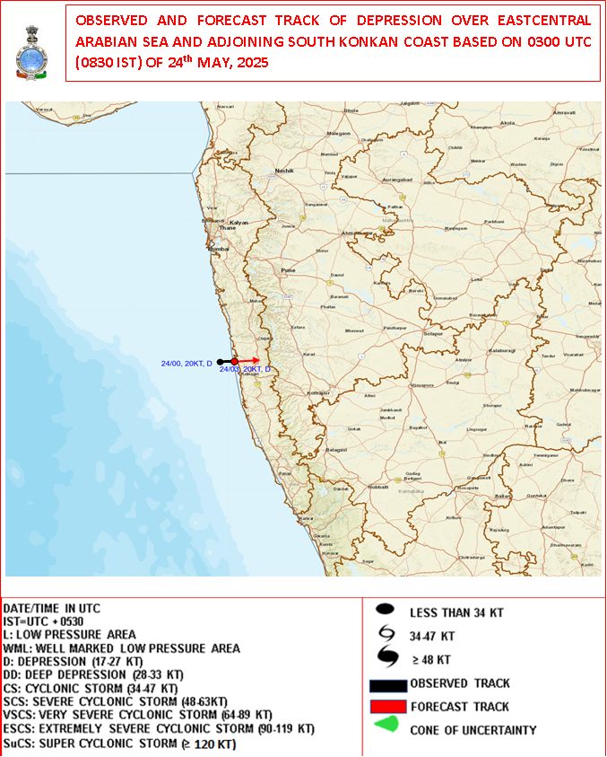
24-05-2025 0000 UTC (08.30 am. IST)
Observed and Forecast Track for Depression Over Arabian Sea
૨૪-૦૫-૨૦૨૫ 0000UTC (08.30 am. IST)
અરબી સમુદ્ર પર સર્જાયેલ ડિપ્રેશન માટે લીકેશન અને ટ્રેક ની આગાહી
️Current Weather Conditions (as of 23rd May 2025)
Maximum Temperature Observations – 22nd May 2025:
-
Rajkot: 42.3°C (1°C above normal)
-
Deesa: 40.6°C (normal)
-
Ahmedabad: 41.0°C (1°C below normal)
- Bhuj: 41.7°C (3°C above normal)
Overall, maximum temperatures across most parts of Gujarat are near normal except Bhuj which was 3°C above normal.
️ Current Synoptic & Expected Weather Features
-
Northern Limit of Monsoon (NLM):
The NLM continues to pass through the following locations:
5°N/60°E, 6°N/65°E, 7°N/70°E, 7°N/75°E, 10°N/81°E, 13°N/84.5°E, 16°N/88°E, 19.5°N/91°E, and 23°N/95°E. -
Monsoon Onset and Advancement:
Conditions are likely to become favorable for the onset of the southwest monsoon over Kerala during the next 2 days.
Additionally, conditions are becoming favorable for the further advance of the southwest monsoon over:-
Some more parts of the South Arabian Sea
-
Remaining parts of the Maldives and Comorin area
-
Some parts of the Lakshadweep area, Kerala, and Karnataka & Tamil Nadu
-
Some more parts of the South & Central Bay of Bengal, North Bay of Bengal, and parts of the Northeastern states
during the same period.
-
-
Low-Pressure Systems and Associated Features:
-
A well-marked low-pressure area lies over the East Central Arabian Sea off the south Konkan coast as of 0830 hrs IST today. It is expected to move nearly northwards and intensify into a depression over the next 24 hours.
-
A trough extends from the cyclonic circulation associated with this system to south Chhattisgarh across south Madhya Maharashtra, south Marathwada, and north Telangana between 1.5 and 5.8 km above mean sea level, and it persists.
-
Another Low-pressure area is likely to form over the West Central and adjoining north Bay of Bengal around 27 May. It is expected to intensify further over the subsequent 2 days.
-
Forecast for Gujarat, Saurashtra & Kutch (Up to 28th May 2025)
️ Wind Patterns:
-
Mainly Winds from West and Southwest and at times Variable winds.
-
Wind Speed: 15–20 km/h; gusts up to 20–30 km/h.
Very high gusts during thunder activity.
️ Sky Conditions:
-
Partly cloudy skies at times increased cloud cover.
️ Pre-Monsoon Activity:
-
Isolated to scattered rain expected over Saurashtra, Kutch & Gujarat region during 23rd–28th May.
The Arabian Sea Well Marked Low Pressure close to the Konkan Coast poses reduced risk For Gujarat State.
️
️દક્ષિણપશ્ચિમ ચોમાસુ ૨૫ મે ૨૦૨૫ સુધીમાં કેરળ પહોંચવાની શક્યતા; સૌરાષ્ટ્ર, કચ્છ અને ગુજરાતમાં પ્રિ-મોન્સૂન એક્ટિવિટી મર્યાદિત રહેવાની સંભાવના
️
વર્તમાન હવામાન સ્થિતિ (૨3 મે ૨૦૨૫ સુધી)
મહત્તમ તાપમાનના પ્રેક્ષણો – ૨2 મે ૨૦૨૫:
-
રાજકોટ: ૪૨.૩°C (સામાન્ય કરતાં ૧°C વધુ)
-
દીસા: ૪૦.૬°C (સામાન્ય)
-
અમદાવાદ: ૪૧.૦°C (સામાન્ય કરતાં ૧°C ઓછું)
-
ભૂજ: ૪૧.૭°C (સામાન્ય કરતાં ૩°C વધુ)
મોટા ભાગના ગુજરાતમાં મહત્તમ તાપમાન સામાન્ય આસપાસ છે, જ્યારે ભૂજમાં ૩°C વધારે તાપમાન નોંધાયું છે.
વર્તમાન સાયનોપ્ટિક અને અપેક્ષિત હવામાન લક્ષણો
મોનસૂનની ઉત્તર સીમા (Northern Limit of Monsoon – NLM):
NLM નીચેના સ્થાનોએ પસાર થાય છે:
5°N/60°E, 6°N/65°E, 7°N/70°E, 7°N/75°E, 10°N/81°E, 13°N/84.5°E, 16°N/88°E, 19.5°N/91°E, 23°N/95°E.
ચોમાસુ પ્રગતિ:
આગામી ૨ દિવસમાં કેરળ પર દક્ષિણપશ્ચિમ ચોમાસુ પ્રારંભ માટે અનુકૂળ પરિસ્થિતિની શક્યતા છે.
સાથે જ, દક્ષિણપશ્ચિમ ચોમાસુ આગળ વધવાની શક્યતા બની રહી છે, જેમાં શામેલ છે:
-
દક્ષિણ અરબી સમુદ્રના કેટલાક ભાગો
-
માલદીવ અને કોમોરિન ક્ષેત્રના બાકી ભાગો
-
લક્ષદ્વીપ, કેરળ, કર્ણાટક અને તમિલનાડુના કેટલાક ભાગો
-
દક્ષિણ અને મધ્ય બંગાળના કેટલાક ભાગો, ઉત્તર બંગાળ અને ઉત્તર-પૂર્વીય રાજ્યોના કેટલાક ભાગો
વેલ માર્કંડ લો પ્રેસર અને સંબંધિત લક્ષણો:
-
આજે સવારે ૮:૩૦ વાગ્યાના IST પ્રમાણે, દક્ષિણ કોંકણ તટની નજીક પૂર્વ મધ્ય અરબી સમુદ્રમાં એક વેલ માર્કંડ લો પ્રેસર વાળો વિસ્તાર સ્થિત છે. આ સિસ્ટમ આગામી ૨૪ કલાકમાં ઉત્તર દિશા તરફ આગળ વધીને વધુ મજબૂત થઈ શકે છે અને ડિપ્રેશનમાં બદલાઈ શકે છે.
-
આને આનુસંગિક સાયક્લોનિક સર્ક્યુલેશનથી એક ટ્રફ દક્ષિણ છત્તીસગઢ સુધી વિસ્તરી રહ્યો છે, જે દક્ષિણ મધ્ય મહારાષ્ટ્ર, દક્ષિણ મારાઠવાડા અને ઉત્તર તેલંગાણાના ભાગો ભાગો પાર થી પસાર થાય છે જે 1.5 થી 5.8 કિમી ઊંચાઈ પર છે.
-
૨૭ મે આસપાસ પશ્ચિમ મધ્ય અને તે સાથે જોડાયેલ ઉત્તર બંગાળમાં એક નવું લો પ્રેસર વાળો વિસ્તાર બનવાની સંભાવના છે, જે આગામી ૨ દિવસમાં વધુ મજબૂત બનશે.
ગુજરાત, સૌરાષ્ટ્ર અને કચ્છ માટે આગાહી (૨૮ મે ૨૦૨૫ સુધી)
પવનની દિશા અને ઝડપ:
-
મુખ્યત્વે પશ્ચિમ અને દક્ષિણપશ્ચિમ દિશાના પવન, ક્યારેક પવનની દિશામાં ફેરફાર.
-
પવનની ઝડપ ૧૫-૨૦ કિમી/કલાક, ત્યારે-ત્યારે ૨૦-૩૦ કિમી/કલાક સુધી ના ઝટકા ના પવનો.
- ગાજ વીજ સમયે અચાનક પવન સ્પીડ વધે અને ફરતા પવનો ની શક્યતા.
આકાશની સ્થિતિ:
-
ક્યારેક છુટા છવાયા વાદળ અને ક્યારેક આકાશ ઘેરાય.
પૂર્વ મોનસૂન પ્રવૃત્તિ:
-
૨૩ થી ૨૮ મે દરમિયાન સૌરાષ્ટ્ર, કચ્છ અને ગુજરાતમાં સીમિત વિસ્તાર થી છુટા છવાયા વિસ્તાર માં પ્રિમોન્સૂન એક્ટિવિટી.
ખાસ નોંધ:
-
અરબી સમુદ્રમાં કોંકણ તટની નજીક આવેલા વેલ માર્કંડ લો પ્રેસર સિસ્ટમ ને કારણે પહેલા કરતા ગુજરાત રાજ્ય માટે જોખમ ઘટેલું છે.
-
⚠️ Advisory
Caution: Please refer/rely on IMD/RSMC Bulletins/Advisories for Storms & Weather related matter.
સાવચેતી: સ્ટોર્મ કે હવામાન અંગે ની માહિતી માટે ભારતીય હવામાન ખાતા/ગવર્મેન્ટ ના બુલેટીન/સુચના પર નિર્ભર રહેવું.
Read Comment Policy – કમેન્ટ માટે માર્ગદર્શન વાંચો
How To Upload Profile Picture For WordPress – વર્ડપ્રેસ માં પ્રોફાઈલ પિક્ચર કેમ રાખવું
BAAKI Forecast In Akila Daily Dated 24th May 2025
BAAKI Forecast In Sanj Samachar Daily Dated 24th May 2025
તારીખ 23 મે 2025 આજની પરિસ્થિતિ ભારતીય હવામાન વિભાગ અનુસાર મીડ ડે બુલેટિન ❖ નૈઋત્ય નું ચોમાસાની રેખા 5°N/60°E, 6°N/65°E, 7°N/70°E, 7°N/75°E, 10°N/81°E, 13°N/84.5°E, 16°N/88°E, 19.5°N/91°E અને 23°N/95°E માંથી પસાર થાય છે. ❖ નૈઋત્ય નું ચોમાસું આગામી 2 દિવસ દરમિયાન કેરળમાં ચોમાસાની શરૂઆત માટે પરિસ્થિતિઓ અનુકૂળ બનવાની શક્યતા છે. ❖ નૈઋત્ય નું ચોમાસું આગામી 2 દીવસ માં દક્ષિણ અરબી સમુદ્રના કેટલાક ભાગો, માલદીવ્સ અને કોમોરિન વિસ્તારના બાકીના ભાગો; લક્ષદ્વીપ વિસ્તાર, કેરળ, કર્ણાટક અને તમિલનાડુના કેટલાક ભાગો; દક્ષિણ અને મધ્ય બંગાળની ખાડી, ઉત્તર બંગાળની ખાડી અને ઉત્તરપૂર્વીય રાજ્યોના કેટલાક ભાગોમાં નૈઋત્ય નું ચોમાસું આગળ વધવા માટે પરિસ્થિતિઓ અનુકૂળ બનવાની શક્યતા છે. … Read more »
Sir mare cola kem khultu nthi ?