Bay System Expected To Give Beneficial Round of Rainfall For Gujarat State: 4th–9th September 2025
બંગાળ ની ખાડી ની સિસ્ટમ ગુજરાત રાજ્યમાં ફાયદારૂપ વરસાદી રાઉન્ડ આપે તેવી અપેક્ષા: 4th–9th સપ્ટેમ્બર 2025
Current Weather Conditions – 3rd September 2025
Meteorological Analysis
(Based on 0530 hours IST of 03rd September 2025)
-
Low Pressure Area (LPA)
-
A well-marked low-pressure area lies over the Northwest Bay of Bengal (NW BoB).
-
The associated cyclonic circulation extends up to 7.6 km above mean sea level (amsl), tilting southwestwards with height.
-
Likely movement: west-northwestwards across Odisha during the next 24 hours.
-
-
Monsoon Trough (Mean Sea Level)
-
The monsoon trough passes through:
Sri Ganganagar → Jaipur → Guna → Jabalpur → Pendra Road → Jharsuguda → centre of the well-marked LPA (NW BoB) → southeastwards into east-central Bay of Bengal.
-
-
Cyclonic Circulation (South Haryana & Neighborhood)
-
Persists over south Haryana & adjoining areas.
-
Extends up to 3.1 km amsl.
-
-
Trough (Mid-tropospheric Levels)
-
A trough runs from Lat. 36°N / Long. 71°E to south Haryana.
-
Present between 3.1 km and 5.8 km amsl.
-
-
Western Disturbance (WD)
-
Present as a trough in the upper tropospheric levels.
-
Axis lies roughly along Long. 72°E, north of Lat. 28°N.
-
Height: 7.6 km amsl.
-
Rainfall Forecast for Saurashtra, Kutch & Gujarat
Period: 4th to 9th September 2025
Gujarat Region – Cumulative Rainfall
- Heavy / Very Heavy rainfall is likely over Isolated areas on some days of the forecast period.
- Some days will see light to moderate rainfall over fairly widespread areas.
- 40% to 60% areas: 50 – 100 mm
- Up to 30% areas: 100 – 200 mm
- Up to 30% areas: could remain below 50 mm
- Stray locations: Could receive cumulative rainfall exceeding 200 mm
Saurashtra & Kutch – Cumulative Rainfall
- Intensity: Heavy / Very Heavy rainfall is likely over Isolated areas on some days of the forecast period.
- Some days will see light to moderate rainfall over scattered to fairly widespread areas
- 40% to 60% areas: 35 – 75 mm
- Up to 30% areas: 75 – 150 mm
- Up to 30% areas: could remain below 35 mm
- Stray locations: Could receive cumulative rainfall exceeding 200 mm

બંગાળ ની ખાડી ની સિસ્ટમ ગુજરાત રાજ્યમાં ફાયદારૂપ વરસાદી રાઉન્ડ આપે તેવી અપેક્ષા: 4th–9th સપ્ટેમ્બર 2025
હવામાન વિશ્લેષણ
(Based on 0530 hours IST of 03rd September 2025)
Low Pressure Area (LPA)
- એક well-marked low-pressure area Northwest Bay of Bengal (NW BoB) પર સ્થિત છે.
- તેની સાથે જોડાયેલ યુએસી (UAC) 7.6 km amsl સુધી વિસ્તરે છે, જે ઊંચાઈ સાથે દક્ષિણ પશ્ચિમ તરફ ઢળે છે.
- શક્ય ગતિ: આવતા 24 hours દરમ્યાન Odisha ઉપરથી પશ્ચિમ-ઉત્તર પશ્ચિમ તરફ.
Monsoon Trough (Mean Sea Level)
- Monsoon trough પસાર થાય છે:
Sri Ganganagar → Jaipur → Guna → Jabalpur → Pendra Road → Jharsuguda → center of well-marked LPA (NW BoB) → East-central Bay of Bengal
યુએસી (South Haryana & Neighborhood)
- South Haryana અને આસપાસના વિસ્તારોમાં યુએસી યથાવત છે.
- તે 3.1 km amsl સુધી વિસ્તરે છે.
Trough (Mid-tropospheric Levels)
- એક trough Lat. 36°N / Long. 71°E થી South Haryana સુધી ફેલાય છે.
- તે 3.1 km થી 5.8 km amsl વચ્ચે હાજર છે.
Western Disturbance (WD)
- એક trough રૂપે upper tropospheric levels માં હાજર છે.
- તેનું axis અંદાજે Long. 72°E, Lat. 28°N થી ઉત્તર તરફ છે.
- ઊંચાઈ: 7.6 km amsl.
વરસાદી આગાહી – Saurashtra, Kutch & Gujarat
સમયગાળો: 4th થી 9th September 2025
ગુજરાત રિજિયન: કુલ વરસાદ
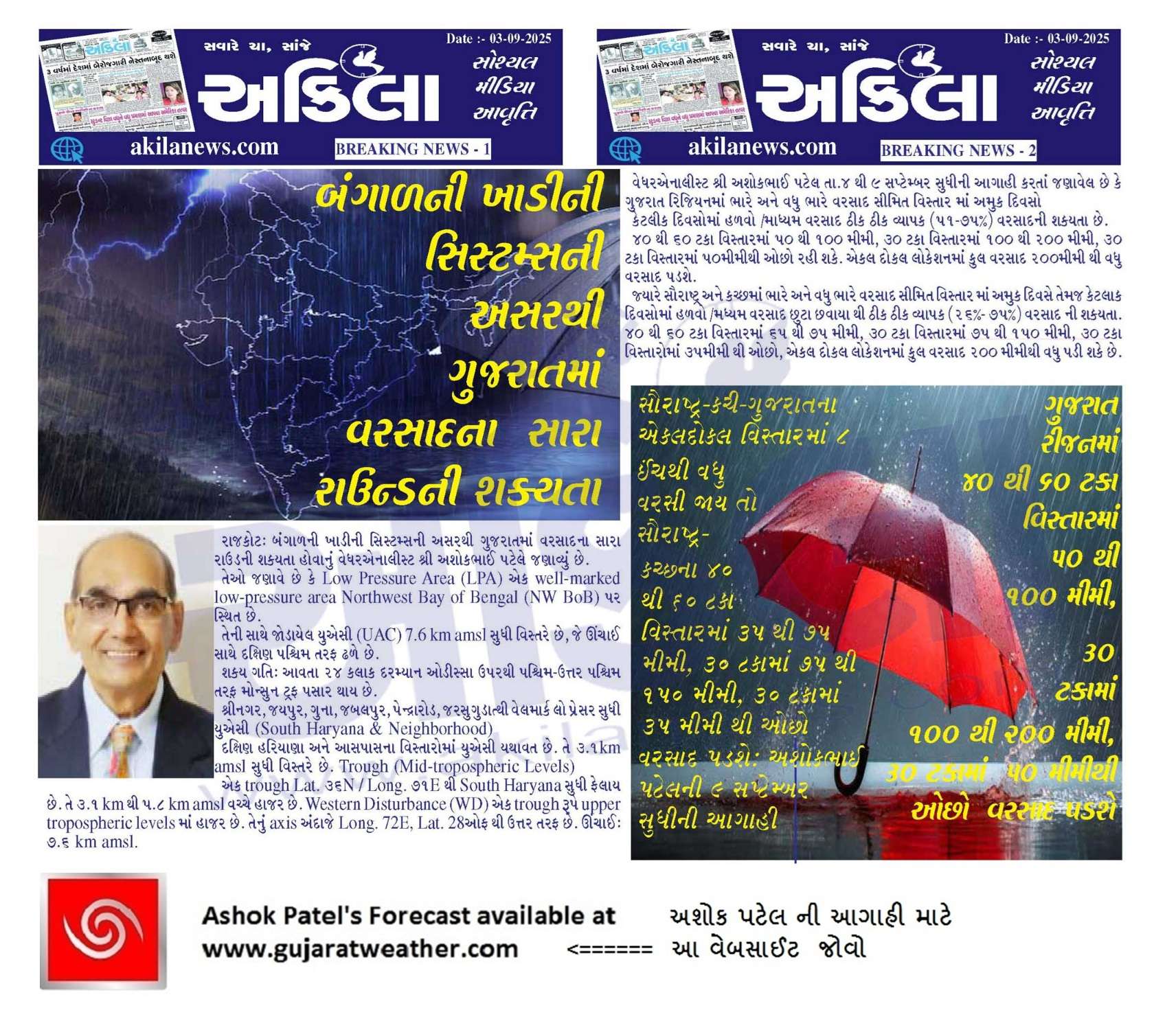
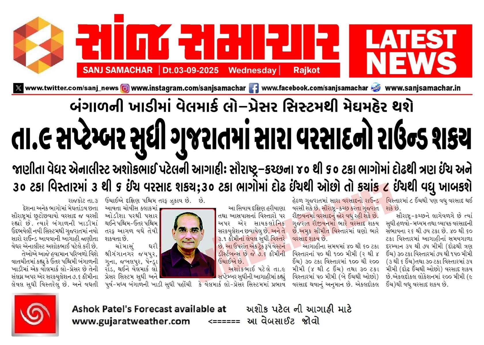
- ભારે અને વધુ ભારે વરસાદ સીમિત વિસ્તાર માં અમુક દિવસો
- કેટલાક દિવસોમાં હળવો /મધ્યમ વરસાદ ઠીક ઠીક વ્યાપક (51–75%) વરસાદ ની શક્યતા.
- 40% to 60% areas: 50 – 100 mm
- 30% વિસ્તાર સુધી: 100 – 200 mm
- 30% વિસ્તાર સુધી: 50 mm થી ઓછો રહી શકે.
- એકલ દોકલ લોકેશન માં : કુલ વરસાદ 200 mm થી વધુ મળી શકે.
સૌરાષ્ટ્ર અને કચ્છ: કુલ વરસાદ
- ભારે અને વધુ ભારે વરસાદ સીમિત વિસ્તાર માં અમુક દિવસો
- કેટલાક દિવસોમાં હળવો /મધ્યમ વરસાદ છુટા છવાયા થી ઠીક ઠીક વ્યાપક (26%–75%) વરસાદ ની શક્યતા.
- 40% to 60% areas: 35 – 75 mm
- 30% વિસ્તાર સુધી: 75 – 150 mm
- 30% વિસ્તાર સુધી: below 35 mm
- એકલ દોકલ લોકેશન માં : કુલ વરસાદ 200 mm થી વધુ મળી શકે.
⚠️ Advisory
Caution: Please refer/rely on IMD/RSMC Bulletins/Advisories for Storms & Weather related matter.
સાવચેતી: સ્ટોર્મ કે હવામાન અંગે ની માહિતી માટે ભારતીય હવામાન ખાતા/ગવર્મેન્ટ ના બુલેટીન/સુચના પર નિર્ભર રહેવું.
Read Comment Policy – કમેન્ટ માટે માર્ગદર્શન વાંચો
How To Upload Profile Picture For WordPress – વર્ડપ્રેસ માં પ્રોફાઈલ પિક્ચર કેમ રાખવું
Forecast In Akila Daily Dated 3rd September 2025
Forecast In Sanj Samachar Daily Dated 3rd September 2025
Tnx sir for new update
Thank you very much….sir
For new update
Thanks sir for new update apava badal
Aj fere pan luck by chance che
Jevi prabhuni marji
Amara vistarma motor chalu ajathi magfalima..
Thanks sir for new update
Thank you sir for new update
Aa vakhte full varsad thay Jay avu lage chhe aagahi samay ma
Thanks sir for new update
અપડેટ આપવા બદલ આભાર સર
Thank you for new update
Thanks for the update sir!!!
Thank you for new update
Ane bhagvanane prathna kariye ke jya ocho varshad thayoche tya vadhu varshad ape
IMD na chart and GFS na chart vache bv motu antar jova made chhe ena pachhad nu reason su hoi sake ?
ECMWF ma pan farak chhe. IMD jor ma chhe…bija badha mapey chhe.
Eni pachhad kai specific Paribad mapey revanu ?
Badha model alag alag ritey hisab karta hoy. Jene jevu dekhay tevy Model batavey.
pachimi jet Ane monsoon wind ni vachhe takrav pan aani pachad hoy sake che
k evi Kay nathi dekhatu sir
mid leval ma kay problem nathi badhu sanukul che etle kav chu
Ama kay khabar nath padti ekey modal jota badha gotha mare chhe
Have jamin upar pade a sachu
Barobar ne shar
Atyare windy ma gfs bav sarubatave chhe sauratra mate navi apdet ma
Sir Thenks new apdey Gondal ma 35mm કે 35mm ઉપાર જણાવવા વિનંતી અમારે માપે જ વરસાદ છે
Thanks saheb
સર અમારા એરિયા માં હજુ સુધી માં બે વખત માંડ માંડ ખેતર ની બારા પાણી નીકળ્યા હસે આ વખતે પણ મને એવું જ લાગે છે પણ હું તમારો અંદાજ જાણવા માંગુ છું તો જવાબ આપવા વિનંતી.
Andaj maate ahi KOLA Maps vividdh model na dar roj update thay chhe. te joa.
Biju ke ECMWF ma 10 divas na 10 Map pan ahi aapel hoy chhe te jovo.
સર જય શ્રીકૃષ્ણ આભાર અપડેટ બદલ…..
Thank you for new update sir
ખૂબ ખૂબ આભાર sir….
Thanks for new update
Saurashtra na purva bhago (Surendranagar Botad Bhavnagar) ma jor vadhu rahi shake chhe….
NG and lagu Saurashtra
Ng mtlb
North Gujarat
અપડેટ બદલ આભાર
બહુ સારા સમાચાર આપ્યા સરજી
વહેલી કે મોડી અપડેટ આપવા બદલ આભાર સર
Thanks sir
Thanks for new update
Thanks sir
Thanks sar new apdet
Thanks sir
Thanks sar new apdet
અપડેટ બદલ આભાર સર
Thanks Sir
અપડેટ બદલ આભાર સર
આભાર સાહેબ
Theks sr.for new apdet
Theks sr.for new apdet
આ રાઉન્ડ માં પણ સૌરાષ્ટ્રમાં લોટરી લાગી જાય ઈ વિસ્તાર ભાગ્યશાળી .
સારા સમાચાર
Thanks for update
સારા સમાચાર
Thanks for update
Thanks for new update sir,
Jay Dwarkadhish.
Thank sir
35 mm bas
ગણપતિદાદા વિસર્જન…વરસાદ..આનંદ…
Thank sir
Thank you sir …for new update
સર વેબસાઇટ મા કંઈ ફોલ્ટ નથી clear cache and cookies data clear કર્યું એટલે બધું નોર્મલ થય ગયું
Amare ahi magfadi pane aavijase 1-2 inch thsy Jay to bhayo bhayo baki ghat che tya bhale bakajiki bolave aeney santosh thay jay
Thanks you Sir
Bhayo bhayo biju su
Je aaviyu e kaik aavshe to khara
તારીખ 3 સપ્ટેમ્બર 2025 આજની પરિસ્થિતિ ભારતીય હવામાન વિભાગ અનુસાર મીડ ડે બુલેટિન 1. **વેલમાર્કડ લો પ્રેશર (Well Marked Low-Pressure Area):** – વેલમાર્કડ લો પ્રેશર આજે 03 સપ્ટેમ્બર 2025 ના રોજ ભારતીય સમયાનુસાર સવારે 08:30 કલાકે ઉત્તર-પશ્ચિમ બંગાળની ખાડીમાં, ઉત્તર ઓડિશા કિનારે છે. – તેનુ આનુષાંગિક UAC સરેરાશ સમુદ્ર સપાટીથી 7.6 કિમી સુધી વિસ્તરે છે જે વધતી ઊંચાઈ એ દક્ષિણ-પશ્ચિમ તરફ ઝુકાવ ધરાવે છે. – આ સીસ્ટમ આગામી 24 કલાકમાં પશ્ચિમ-ઉત્તરપશ્ચિમ દિશામાં ઉત્તર ઓડિશા, લાગુ ઝારખંડ અને ઉત્તર છત્તીસગઢમાં આગળ વધે તેવી શક્યતા છે. 2. **ચોમાસાની ધરી (Monsoon Trough):** – સરેરાશ સમુદ્ર સપાટી પર ચોમાસાની ધરી હવે બિકાનેર, જયપુર, દમોહ,… Read more »
Vah sir wah have September j ભેગું karse