Southwest Monsoon Sets In Over Parts of Coastal Saurashtra and Parts of Gujarat Region Today 16th June 2025
દક્ષિણ પશ્ચિમ ચોમાસું કોસ્ટલ સૌરાષ્ટ્ર ના ભાગો તેમજ ગુજરાત રિજિયન ના ભાગો માં આજે તારીખ 16th June 2025 ના પ્રવેશ્યું
Current Weather Conditions – 16th June 2025
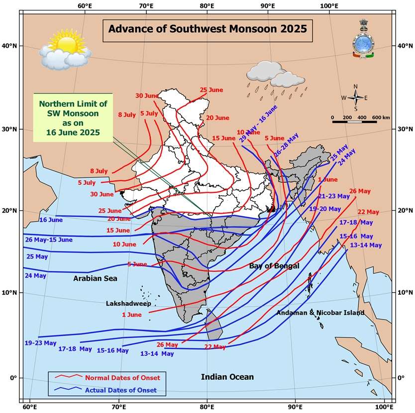
The Southwest Monsoon has further advanced into the following regions:
- Entire Konkan and Madhya Maharashtra
- Parts of Coastal Saurashtra and parts of Gujarat Region
- Southwest Madhya Pradesh
- Some more parts of Vidarbha, Chhattisgarh, Odisha
- Sub-Himalayan West Bengal & Sikkim (partial advancement)
Current Synoptic Conditions
Northern Limit of Monsoon (NLM)
As of 16th June 2025, the Northern Limit of Monsoon passes through:
20.0°N/60°E, 20.5°N/65°E, Veraval, Bhavnagar, Vadodara, Khargone, Amravati, Durg, Bargarh, Chandbali, Sandhead Island, 23.5°N/89.5°E, Balurghat, and 30.0°N/85.0°E
Monsoon Advancement Outlook
Favorable conditions are expected for further advancement of the Southwest Monsoon into:
- More parts of Gujarat and Madhya Pradesh
- Remaining parts of Vidarbha
- More parts of Chhattisgarh and Odisha
- Remaining parts of Sub-Himalayan West Bengal & Sikkim (within the next 24 hours)
- Parts of West Bengal, Jharkhand, Bihar, and East Uttar Pradesh (during the subsequent 2 days)
Synoptic Features
- An upper air cyclonic circulation lies over the Northwest Bay of Bengal and adjoining areas, tilting southwestward with height in the lower and middle tropospheric levels.
- Another cyclonic circulation is observed over South Gujarat and nearby regions in the middle tropospheric levels.
- Under its influence, a Low-Pressure Area is likely to form over the same region in the next 24 hours.
- It is expected to move north-northwestwards and become more marked in the following 24 hours.
Also refer to the forecast update dated 14th June 2025 for additional context
️
દક્ષિણ પશ્ચિમ ચોમાસું કોસ્ટલ સૌરાષ્ટ્ર ના ભાગો તેમજ ગુજરાત રિજિયન ના ભાગો માં આજે તારીખ 16th June 2025 ના પ્રવેશ્યું
️
તારીખ: 16મી જૂન 2025
વર્તમાન હવામાન સ્થિતિ – 16મી જૂન 2025
દક્ષિણ પશ્ચિમ ચોમાસું આગળ વધીને નીચેના વિસ્તારોમાં પ્રવેશી ગયું છે:
-
સમગ્ર કોંકણ અને મધ્ય મહારાષ્ટ્ર
-
કોસ્ટલ સૌરાષ્ટ્ર ના ભાગો તેમજ ગુજરાત રિજિયન ના ભાગો માં
-
દક્ષિણ પશ્ચિમ મધ્ય પ્રદેશ
-
વિદર્ભ, છત્તીસગઢ, ઓડિશાના કેટલાક વધુ ભાગો
-
સબ-હિમાલયન પશ્ચિમ બંગાળ અને સિક્કિમના કેટલાક ભાગો
ચોમાસાની ઉત્તરી સીમા (NLM)
16મી જૂન 2025ની સ્થિતિ મુજબ, ચોમાસાની ઉત્તર સીમા નીચેના સ્થળોમાંથી પસાર થાય છે:
20.0°N/60°E, 20.5°N/65°E, વેરાવળ, ભાવનગર, વડોદરા, ખંડવા, અમરાવતી, દુર્ગ, બરગઢ, ચાંદબલી, સેન્ડહેડ આઈલેન્ડ, 23.5°N/89.5°E, બાલુરઘાટ અને 30.0°N/85.0°E
ચોમાસું આગળ વધવાનો અંધાજ
ચોમાસું આગળ વધવા માટે પરિસ્થિતિ અનુકૂળ છે, અને તે નીચેના વિસ્તારોમાં આગળ વધી શકે છે:
-
ગુજરાત અને મધ્ય પ્રદેશના વધુ વિસ્તારો
-
વિદર્ભના બાકી રહેલા વિસ્તારો
-
છત્તીસગઢ અને ઓડિશાના વધુ વિસ્તારો
-
સબ-હિમાલયન પશ્ચિમ બંગાળ અને સિક્કિમના બાકી રહેલા વિસ્તારો (આગામી 24 કલાકમાં)
-
પશ્ચિમ બંગાળ, ઝારખંડ, બિહાર અને પૂર્વ ઉત્તર પ્રદેશના કેટલાક ભાગો (આગામી 2 દિવસોમાં)
વાતાવરણીય પરિબળો
-
એક UAC ઉત્તર પશ્ચિમ બંગાળની ખાડી અને આસપાસના વિસ્તારોમાં જોવા મળે છે, જે નીચલા અને મધ્યમ સ્તરે ઊંચાઈ પર દક્ષિણ પશ્ચિમ તરફ ઢળી રહી છે।
-
બીજું એક UAC દક્ષિણ ગુજરાત અને નજીકના વિસ્તારોમાં મધ્યમ સ્તરે પ્રવર્તી રહ્યું છે।
-
તેની અસર હેઠળ, આગામી 24 કલાકમાં લો પ્રેસર આ વિસ્તારમાં વિકસવાની શક્યતા છે।
-
આ સિસ્ટમ ઉત્તર-ઉત્તર પશ્ચિમ દિશામાં ખસે તેવી સંભાવના છે અને તે આગળ WMLP બની શકે છે (આગામી 24 કલાકમાં).
- વધુ માહિતી માટે 14મી જૂન 2025ની આગાહી અપડેટ પણ જુઓ.
-
-
⚠️ Advisory
Caution: Please refer/rely on IMD/RSMC Bulletins/Advisories for Storms & Weather related matter.
સાવચેતી: સ્ટોર્મ કે હવામાન અંગે ની માહિતી માટે ભારતીય હવામાન ખાતા/ગવર્મેન્ટ ના બુલેટીન/સુચના પર નિર્ભર રહેવું.
Read Comment Policy – કમેન્ટ માટે માર્ગદર્શન વાંચો
How To Upload Profile Picture For WordPress – વર્ડપ્રેસ માં પ્રોફાઈલ પિક્ચર કેમ રાખવું
Forecast In Akila Daily Dated 16th June 2025
Forecast In Sanj Samachar Daily Dated 16th June 2025
દક્ષિણ ગુજરાત અને તેના આસપાસના વિસ્તારો પર UAC ના પ્રભાવ હેઠળ, આજે ૧૭ જૂન ૨૦૨૫ ના રોજ ભારતીય સમય મુજબ સવારે ૦૫.૩૦ કલાકે ગુજરાત અને તેના આસપાસના વિસ્તારોમાં લો પ્રેશર રચાયુ છે. આગામી ૨૪ કલાક દરમિયાન આ સીસ્ટમ વધુ તીવ્ર બને અને ઉત્તર-ઉત્તરપશ્ચિમ તરફ આગળ વધે તેવી શક્યતા છે.
જમીન પર જો UAC માંથી low બને ને તેમાંથી wmlp બનવાની આગાહી છે. તો તેની તીવ્રતા વધુ હોય શકે? જેની દિશા મુખ્યત્વે ઉત્તર પશ્ચિમ હોય તો સૌરાષ્ટ્ર માટે અતિભારે વરસાદ આગામી 3 દિવસ માં થઈ શકે ?
IMD GFS na MSLP na chart ma batavey chhe Low Pressure aavati kaal and WMLP Wednesday na
Good evening sir,
Extremely heavy rain chalu che Palitana ni najik na area ma, amuk amuk center ma 10 inch + che, Still raining.
Thank You Sir For New Update…. Jay Shree Radhe Krishna Ji….
Vadodara na alag alag vistaaro ma gajvij sathe ane pawan sathe dhodhmar to kyak madhyam varsad padyo
Last 2-3 years bhavnagar panthak ma saurashtra na anay district karta ocho varsad thato khas kari ne jesar taluka ma , aa vakhte pratham varsad ma j tya kudarate pahela het varsavi didhu.
Botad ma dhamakedar entry
Thanks you sirfor new update aapava badal
Abhar
આજે અમારા ગામ હાથીગઢમાં સવારે પાંચ વાગ્યાથી 12 વાગ્યા સુધીનો અડધો ઇંચ વરસાદ. અને બાર વાગ્યાથી 5:30 વાગ્યા સુધીના સાડા ચાર ઈસ વરસાદની હજુ અવિરત શરૂ. ચાર વાગ્યા પછી પવનની ગતિ પણ વધી ગઈ છે. ઘણા વર્ષો પછી આવી વાવણીનો લાભ અમને મળ્યો. અને અમારથી વધુ ગારીયાધાર પાલીતાણા ડિસ્ટ્રિક્ટ મ ખૂબ જ વરસાદ અતિ ભારે વરસાદ.
Can anyone guide me on which models can be studied for rain prediction. Imd GFS & windy na various filters ni khabar che mne.. but aa sivay kai links ke models study kri skai rainfall prediction mate
Weather wunderground, The weather channel, AccuWeather… This are the weather models which are nearly 60 to 70 percent accurate for rainfall prediction.
આભાર સાહેબ, સર કોસ્ટલ સૌરાષ્ટ્ર એટલે ભાવનગરથી વેરાવળ સુધી જ કે ભાવનગરથી ઓખા સમજવાનું ?
Haal Verval thi Bhavnagar.
દક્ષિણ પશ્ચિમ ચોમાસું કોસ્ટલ સૌરાષ્ટ્ર ના ભાગો તેમજ ગુજરાત રિજિયન ના ભાગો માં
રામ રામ, સર ડૂસા કાઢી નાખા દામનગર. ઞારીયાધાર. પાલીતાણા ૪થી8ઈચ.અમારા ઞામમા ઞાડા મારઞ વિખેરી નાખ્યા.કેડાના પાણી ખેતરમા ચડાવી દીઘા
Thanks for new information sir.
Amare bhoringada bov nuksaan karak varsad padiyo bov j nuksaani se
Thank you for new update
અને વ્હાલાંના વધામણાં ની રાહ
Theks for new apdet
Bhavnagar – Amreli – Somnath district no varo aavyo, tyar pachhi jem system North baju aagad vadhshe tem Rajkot, Jamnagar, Botad, Surendranagar, Morbi no varo pan aavse.
Amare ajno varsad4lnch
Thanks for update sir,aje costal surastrana mahuva,rajula,savarkundla areane ritsarna dhoy nakhya varsade andaje 7″ To 10″ Sudhino varsad che nadi nala full speed ma jay che last 13 calak this continue varsad che.ati bhare varsad.
Thankyou sir
Sir Rajkot Morbi vistar ma varsad no labh malijase aaj bapor rat thi kal sanj suthi ma barobar ne sar
સર આ રાઉન્ડ માં ગીર ના ગામડા માં માત્ર છાંટા જ આવ્યા વધારે વરસાદ ની શક્યતા રહેલી છે કે ?
તારીખ 16 જુન 2025 આજની પરિસ્થિતિ ભારતીય હવામાન વિભાગ અનુસાર મીડ ડે બુલેટિન ❖ આજે નૈઋત્ય નું ચોમાસું સમગ્ર કોંકણ, મધ્ય મહારાષ્ટ્ર; ગુજરાત રાજ્યના કેટલાક ભાગો, દક્ષિણ પશ્ચિમ મધ્ય પ્રદેશ; વિદર્ભ, છત્તીસગઢ, ઓડિશા અને સબ-હિમાલયન પશ્ચિમ બંગાળ અને સિક્કિમના કેટલાક ભાગોમાં આગળ વધ્યું છે. ❖ નૈઋત્ય ના ચોમાસાની રેખા હવે 20.0°N/60°E, 20.5°N/65°E, વેરાવળ, ભાવનગર, વડોદરા, ખરગોન, અમરાવતી, દુર્ગ, બારગઢ, ચાંદબાલી, સેન્ડહેડ આઇલેન્ડ, 23.5°N/89.5°E, બાલુરઘાટ અને 30°N/85°E માંથી પસાર થાય છે. ❖ નૈઋત્ય નું ચોમાસું આગામી 24 કલાક દરમિયાન ગુજરાત અને મધ્યપ્રદેશના કેટલાક ભાગો; વિદર્ભના બાકીના ભાગો; છત્તીસગઢ અને ઓડિશાના કેટલાક ભાગો; સબ-હિમાલયન પશ્ચિમ બંગાળ અને સિક્કિમના બાકીના ભાગો તેમજ આગામી… Read more »
Jsk સર…. જે wmlp ની વાત કયરી તમે તેની ઉપર વધારે આશા જાયગી હવે… જોઈએ બન્યા પછી કેટલુંક ઉત્તર તરફ ચાલે..વેસ્ટ બાજુ ચાલે ઈની પેલા જેટલું વધારે ઉત્તર માં હાલે એટલો ફાયદો સૌરાષ્ટ્ર માટે.. બરોબર ને સર??
આખો દિવસ ખુબજ કાળા વાદળો રહયા પણ વરસાદ માત્ર ધીમો ધીમો આવ્યો
સાવરકુંડલા/ખંભાના ગ્રામ્ય વિસ્તારોમાં ભારે વરસાદ પડી રહ્યો છે
नमस्ते सर जानकारी बदल सह आभार सब सरको
Thanks sir
આભાર નવી અપડેટ આપવા બદલ અશોક સર
તો સરજી આ રાઉન્ડમાં જામજોધપુર માં વાવણી લાયક વરસાદ થઈ જશે એવી આશા રાખી શકાય?
Sir saurashtra ma hve agal vadhche
Somaso ke hji var lag chhe
Gujarati ma lakhel chhe.
Good after noon sir
Thanks for update
In wunderground for Rajkot its showing 6.5 inch is it true??
That much of rainfall possible ?
Indication samjo
Thanks sir for new update apava badal well come to monsoon 2025
Visavadar ma Gear nathi badalto..tapak..tapak
Bhavnagar city ma fare ek saro varsadi round saru thayo che
Thanks for update
દિવસ 2.30 ના ટાઈમે સિસ્ટમ ખંભાત ની આજુબાજુ જોવા મળી રહી છે.. સિસ્ટમ ના કેન્દ્રથી પક્ષિમ દિશા તરફ વાદળો નો મુખ્ય ગંજ જોવા મળતો હોવાથી આજે મધ્ય રાત્રિ સુધી સૌરાષ્ટ્ર ના ઘણા વિસ્તારોમાં અવિરત મેઘસવારી ચાલુ રહેશે.. મોડી સાંજે મધ્ય ગુજરાત ના પણ ઘણા વિસ્તારોમાં વરસાદી માહોલ જમાવટ કરશે…
Welcome monsoon 2025.
Aa vakhte chomasu saru Jay tevi iswar ne prarthna….
કેમ છો સાહેબ!
Aaje સવારથી દામનગર ગારિયાધાર પાલીતાણા અને તેના ગામોમાં વ્યાપક વરસાદ સવારથી ચાલુ
ચોમાસુ ધમાકેદાર એન્ટ્રી સાથે બેઠુ બોવ વરસાદ પડ્યો અંદાજે 6 થી 7 ઇંચ welcome monsoon 2025
Rajkot city no vaaro avi shake raat sudhima?
Thank new date
Sir saurashtra ma hve agal vashche chomasu ke hji var lag chhe
Well come monsoon 2025
App na andaj pramane Ghana vistaro no varo kadhi nakhyo Anando.
સર જય શ્રીકૃષ્ણ આભાર અપડેટ બદલ….
Wow that’s some good news for all us
આભાર નવી અપડેટ બદલ અને આજ ના વરસાદિ માહોલ નો શુભારંભ
Porbandar City ma Savare 11:30 vaga thi 1 kalak Bhare varsad pdyo Haal continue dhimi dhare chalu.
Thank you sir….sir 2 mathi kyu UAC low banse…?
Jeni niche lakhel hoy tyan
Thx sir new update