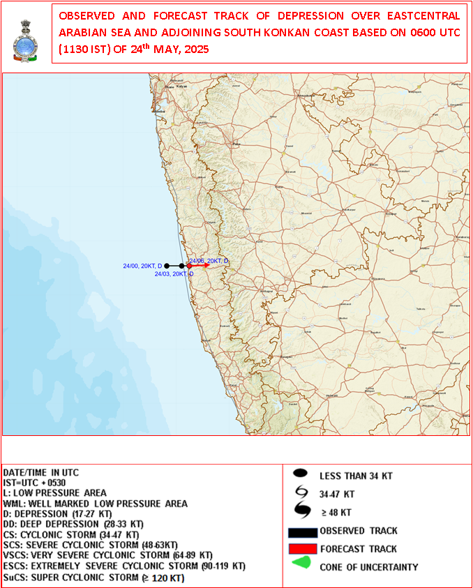
Southwest Monsoon Arrives Over Kerala & Parts of Karnataka – The Depression Over Coastal South Konkan Moving Eastwards Over Land
દક્ષિણ પશ્ચિમ ચોમાસું કેરળ અને કર્ણાટકના કેટલાક ભાગોમાં પ્રવેશી ગયું – દક્ષિણ કોકણ તટ પરનું ડિપ્રેશન પૂર્વ દિશામાં જમીન તરફ ખસી રહ્યું છે
24-05-2025 0600 UTC (11.30 am. IST)
Observed and Forecast Track for Depression Over Arabian Sea
૨૪-૦૫-૨૦૨૫ 0600UTC (11.30 am. IST)
અરબી સમુદ્ર પર સર્જાયેલ ડિપ્રેશન માટે લીકેશન અને ટ્રેક ની આગાહી
-
Current Synoptic Conditions & Expected Weather Features
Date: 24 May 2025
The Depression over East Central Arabian Sea and adjoining south Konkan coast moved slowly eastward with a speed of 6 kmph during past 3 hours and lay centered at 0830 Hrs IST of today, the 24th May 2025 over the same region close to south Konkan coast near latitude 17.20 N & longitude 73.20 E, about 30 km north-northwest of Ratnagiri and 70 km south of Dapoli.
It is likely to continue to move nearly eastwards and cross south Konkan coast between Ratnagiri and Dapoli as a depression by noon of today, the 24th May 2025.
-
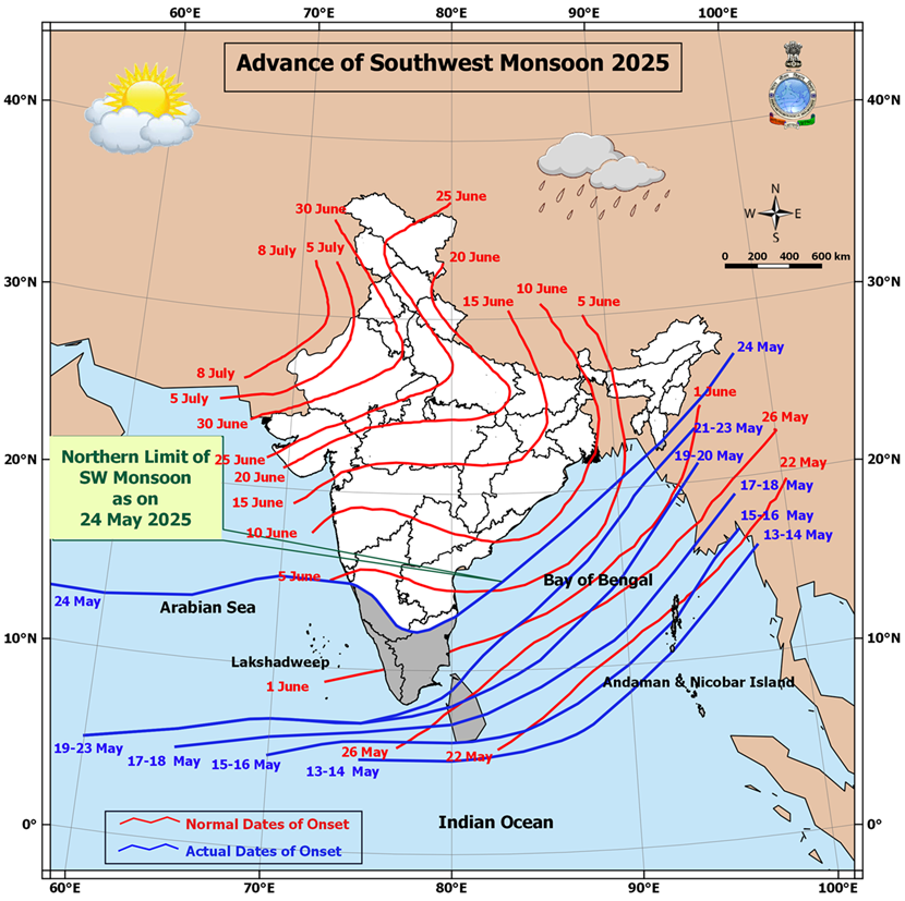
Southwest Monsoon Progress:
The Southwest Monsoon has further advanced into:
-
Remaining parts of south Arabian Sea
-
Parts of West central and East Central Arabian Sea
-
Entire Lakshadweep area, Kerala, and Mahe
-
Some parts of Karnataka
-
Remaining parts of Maldives and Comorin area
-
Many parts of Tamil Nadu
-
Remaining areas of southwest and eastcentral Bay of Bengal
-
Parts of West Central and North Bay of Bengal
-
Some parts of Mizoram
With this, the Southwest Monsoon has officially set in over Kerala today, 24th May 2025, which is ahead of its normal onset date of 1st June.
Northern Limit of Monsoon (NLM):
As of today, the NLM passes through the following coordinates and locations:
13°N/55°E – 13°N/60°E – 13.5°N/65°E – 15°N/70°E – Karwar – Shimoga – Dharmapuri – Chennai – 15°N/83°E – 18°N/87°E – Saiha – 25°N/96°E – 27°N/98°E
Outlook for Monsoon Advancement (Next 2–3 Days):
Conditions are favorable for further advancement of the Southwest Monsoon into:
-
More parts of the central Arabian Sea
-
Entire Goa
-
Some parts of Maharashtra and Andhra Pradesh
-
Additional areas of Karnataka and Tamil Nadu
-
More regions of West Central and North Bay of Bengal
-
Additional parts of the northeastern states
-
Some areas of Sub-Himalayan West Bengal and Sikkim
Trough Details:
-
A trough is currently extending from the the cyclonic circulation associated with the Depression over the South Konkan coast to south Madhya Maharashtra, south Marathwada, and north Telangana
-
This trough lies between 1.5 km and 3.1 km above mean sea level.
Low-Pressure Development Watch:
-
A new low-pressure area is likely to form over the West Central and adjoining north Bay of Bengal around 27th May.
-
Forecast for Gujarat, Saurashtra & Kutch (Up to 28th May 2025)
️ Wind Patterns:
-
Mainly Winds from West and Southwest and at times Variable winds.
-
Wind Speed: 15–20 km/h; gusts up to 20–30 km/h.
Very high gusts during thunder activity exceeding 50 km/hour
️ Sky Conditions:
-
Partly cloudy skies at times increased cloud cover.
️ Pre-Monsoon Activity:
-
Isolated to scattered rain expected over Saurashtra, Kutch & Gujarat region during 24th–28th May.
️
દક્ષિણ પશ્ચિમ ચોમાસું કેરળ અને કર્ણાટકના કેટલાક ભાગોમાં પ્રવેશી ગયું – દક્ષિણ કોકણ તટ પરનું ડિપ્રેશન પૂર્વ દિશામાં જમીન તરફ ખસી રહ્યું છે
️
️
વર્તમાન સિનોપ્ટિક સ્થિતિઓ અને અપેક્ષિત હવામાન લક્ષણો
તારીખ: 24 મે 2025
અરબ સાગરમાં ડિપ્રેશનની સ્થિતિ:
પૂર્વમધ્ય અરબ સાગર અને તે સાથે સંલગ્ન દક્ષિણ કોકણ તટ પર સર્જાયેલી ડિપ્રેશન છેલ્લા 3 કલાકમાં અંદાજે 6 કિમી પ્રતિ કલાકની ગતિએ ધીમે ધીમે પૂર્વ દિશામાં ખસેલી છે.
આજના 24 મે 2025ના રોજ ભારતીય માનક સમય મુજબ સવારે 8:30 વાગ્યે આ ડિપ્રેશન 17.2° ઉ.અ. અક્ષાંશ અને 73.2° પૂ.દે. રેખાંશ નજીક, દક્ષિણ કોકણ તટ પર રતનગિરિથી અંદાજે 30 કિમી ઉત્તર-ઉત્તરપશ્ચિમે અને દાપોલીથી 70 કિમી દક્ષિણમાં કેન્દ્રિત હતું.
આ સિસ્ટમની પૂર્વ દિશામાં ખસેલી રહી અને આજે બપોર સુધી રતનગિરિ અને દાપોલી વચ્ચે કોકણ તટને ડિપ્રેશન તરીકે પાર કરવાનો સંભવિત અંદાજ છે.
️ દક્ષિણ પશ્ચિમ ચોમાસાની પ્રગતિ:
દક્ષિણ પશ્ચિમ ચોમાસું હવે આગળ વધ્યું છે:
-
દક્ષિણ અરબ સાગરના બાકી રહેલા ભાગોમાં
-
પશ્ચિમમધ્ય અને પૂર્વમધ્ય અરબ સાગરના કેટલાક ભાગોમાં
-
આખા લક્ષદ્વીપ, કેરળ, અને મહે વિસ્તારમાં
-
કર્ણાટકના કેટલાક ભાગોમાં
-
માલદ્વીપ અને કુમોરીન વિસ્તારના બાકી ભાગોમાં
-
તમિલનાડુના ઘણા વિસ્તારોમાં
-
પશ્ચિમદક્ષિણ અને પૂર્વમધ્ય બંગાળની ખાડીના બાકી વિસ્તારોમાં
-
પશ્ચિમમધ્ય અને ઉત્તર બંગાળની ખાડીના કેટલાક ભાગોમાં
-
મિઝોરમના કેટલાક ભાગોમાં
આ સાથે, દક્ષિણ પશ્ચિમ ચોમાસું આજના રોજ, એટલે કે 24 મે 2025ના રોજ કેરળ પર સત્તાવાર રીતે પ્રવેશી ગયું છે, જે તેનું સામાન્ય આગમન દિવસ 1 જૂન કરતાં પહેલા છે.
ચોમાસાની ઉત્તરી સીમા (Northern Limit of Monsoon – NLM):
આજના રોજ ચોમાસાની ઉત્તરી સીમા નીચે દર્શાવેલી સ્થાનરેખાઓ અને સ્થળોથી પસાર થાય છે:
13°N/55°E – 13°N/60°E – 13.5°N/65°E – 15°N/70°E – કરવાર – શિમોગા – ધર્મપુરી – ચેન્નાઈ – 15°N/83°E – 18°N/87°E – સાઇહા – 25°N/96°E – 27°N/98°E
આગામી 2-3 દિવસ માટે ચોમાસાની આગળ વધવાની શક્યતા:
અગામી 2-3 દિવસોમાં દક્ષિણ પશ્ચિમ ચોમાસું આગળ વધવાની અનુકૂળ પરિસ્થિતિઓ નોંધાઈ રહી છે. ચોમાસું આગળ વધી શકે છે:
-
મધ્ય અરબ સાગરના વધુ વિસ્તારોમાં
-
આખા ગોવા વિસ્તારમાં
-
મહારાષ્ટ્ર અને આંધ્ર પ્રદેશના કેટલાક વિસ્તારોમાં
-
કર્ણાટક અને તમિલનાડુના વધુ વિસ્તારોમાં
-
પશ્ચિમમધ્ય અને ઉત્તર બંગાળની ખાડીના વધુ વિસ્તારોમાં
-
ઉત્તરપૂર્વ ભારતના વધારાના ભાગોમાં
-
સબ-હિમાલયન પશ્ચિમ બંગાળ અને સિક્કિમના કેટલાક ભાગોમાં
️ ત્રફ રેખાની વિગતો:
ડિપ્રેશન ડિપ્રેસન આનુસંગિક યુએસી દક્ષિણ કોકણ તટથી લઈને દક્ષિણ મધ્ય મહારાષ્ટ્ર, દક્ષિણ મરાઠવાડા અને ઉત્તર તેલંગાણા સુધી એક ત્રફ રેખા સર્જાઈ રહી છે. આ ત્રફ રેખા સમુદ્ર સપાટીથી 1.5 કિમીથી 3.1 કિમીની ઊંચાઈએ આવેલ છે.
ન્યુનતમ લો પ્રેસર વિસ્તાર પર નજર:
એક નવું લો પ્રેસર ક્ષેત્ર 27 મે આસપાસ મધ્ય પશ્ચિમ અને સંલગ્ન ઉત્તર બંગાળની ખાડીમાં વિકસી શકે છે.
ગુજરાત, સૌરાષ્ટ્ર અને કચ્છ માટે આગાહી (૨૮ મે ૨૦૨૫ સુધી)
પવનની દિશા અને ઝડપ:
-
મુખ્યત્વે પશ્ચિમ અને દક્ષિણપશ્ચિમ દિશાના પવન, ક્યારેક પવનની દિશામાં ફેરફાર.
-
પવનની ઝડપ ૧૫-૨૦ કિમી/કલાક, ત્યારે-ત્યારે ૨૦-૩૦ કિમી/કલાક સુધી ના ઝટકા ના પવનો.
- ગાજ વીજ સમયે અચાનક પવન સ્પીડ વધે અને ફરતા પવનો ની શક્યતા.
આકાશની સ્થિતિ:
-
ક્યારેક છુટા છવાયા વાદળ અને ક્યારેક આકાશ ઘેરાય.
પૂર્વ મોનસૂન પ્રવૃત્તિ:
-
૨4 થી ૨૮ મે દરમિયાન સૌરાષ્ટ્ર, કચ્છ અને ગુજરાતમાં સીમિત વિસ્તાર થી છુટા છવાયા વિસ્તાર માં પ્રિમોન્સૂન એક્ટિવિટી.
-
⚠️ Advisory
Caution: Please refer/rely on IMD/RSMC Bulletins/Advisories for Storms & Weather related matter.
સાવચેતી: સ્ટોર્મ કે હવામાન અંગે ની માહિતી માટે ભારતીય હવામાન ખાતા/ગવર્મેન્ટ ના બુલેટીન/સુચના પર નિર્ભર રહેવું.
Read Comment Policy – કમેન્ટ માટે માર્ગદર્શન વાંચો
How To Upload Profile Picture For WordPress – વર્ડપ્રેસ માં પ્રોફાઈલ પિક્ચર કેમ રાખવું
BAAKI Forecast In Akila Daily Dated 24th May 2025
BAAKI Forecast In Sanj Samachar Daily Dated 24th May 2025
તારીખ 30 મે 2025 આજની પરિસ્થિતિ ભારતીય હવામાન વિભાગ અનુસાર મીડ ડે બુલેટિન ❖ નૈઋત્ય ના ચોમાસાની રેખા 17.0°N/55°E, 17.5°N/60°E, 18°N/65°E, 18.5°N/70°E, મુંબઈ, અહિલ્યાનગર, આદિલાબાદ, ભવાનીપટના, પુરી, સેન્ડહેડ આઇલેન્ડ, 23.5°N/89.5°E, બલુરઘાટ અને 30°N/85°E માંથી પસાર થાય છે. ❖ બાંગ્લાદેશ પરનું ડિપ્રેશન છેલ્લા 6 કલાક દરમિયાન 18 કિમી પ્રતિ કલાકની ઝડપે ઉત્તર-ઉત્તરપૂર્વ તરફ આગળ વધ્યું અને આજે 30 મે 2025 ના રોજ ભારતીય સમય મુજબ સવારે 08:30 કલાકે બાંગ્લાદેશ પર 24.4°N અક્ષાંશ અને 89.6°E રેખાંશ નજીક, ટાંગૈલ (બાંગ્લાદેશ) થી લગભગ 40 કિમી પશ્ચિમ-ઉત્તરપશ્ચિમ, ઢાકા (બાંગ્લાદેશ) થી 110 કિમી ઉત્તરપશ્ચિમ, બહેરામપુર (ભારત) થી 140 કિમી ઉત્તર અને શિલોંગ (ભારત) થી 260 કિમી… Read more »
What is the Bharat Forecast System (BFS)? The Bharat Forecast System (BFS) is a short-range deterministic weather prediction model developed and run by IMD and IITM (Indian Institute of Tropical Meteorology). Key Features of IMD’s BFS: Full form: Bharat Forecast System Time Range: Short-range forecast — up to 3 days (72 hours) Resolution: High-resolution (~6 km grid scale) Output: Rainfall, wind, temperature, and other weather parameters Based on: Dynamical core similar to NCMRWF’s Unified Model or customized version of GFS/WRF Purpose: Operational weather forecasts for India with better regional accuracy IMD (ભારત હવામાન વિભાગ) દ્વારા વપરાતા BFS નો અર્થ છે… Read more »
BFS charts for India and Gujarat have been added in Menu
BFS ચાર્ટ્સ ઇન્ડિયા એન્ડ ગુજરાત માટે મેનુ માં સામેલ કરેલ છે.
4 week charts have been updated.
4 અઠવાડિયા ના ચાર્ટ્સ અપડેટ થયા છે.
Wah Thank You Sir… Jay Shree Radhe Krishna Ji….
Bsf insted of bfs in main manu
Edited
ane jovanu kai rite amo kai khabar padti nahti bfs kya lakhelu avtu nathi sar
App ma Menu ma Weather charts click karo etle dekhashe BFS and tene click karo
Aavu khulse
BFS click karo etle agad nu batavashe
Jay mataji sir….gajvij sathe dodhmar varsad ni sharuvat thai 6e…
Surendranagar full pavan sathe dhodhmar varsad chalu
Jay mataji sir….varsad na aavyo aaje pan bhare pavan funkayo…atare vijdi thay varsad nthi…
Ahmedabad Dholka
Kadak bhadaka ane vavajoda sathe dodhmar varsad
Jordar aandhi sathe hdva vij chmkara chalu che
મીની વાવાઝોડું આયું ભાઈ લાઈફ માં પેલી વાર આટલો પવન જોયો ધીમાં ધીમાં છાટા પડે છે
Namste sir આજે અંબાજી મા વરસાદ થયો & દાંતા આજુ બાજુ ગાજ વીજ પવન છે સર વરસાદ નથી છાંટા આવ્યા બંધ થઈ ગયો
Jay mataji sir….aaje sami sajna ishan khuna ma vijdi na chamakara chalu thaya 6e…
jo badhu havaman ane forcastaro ke em thay to kudrat ne kon mane.mate aagahi badhi sasi nathi hoti.
ગુજરાત, સૌરાષ્ટ્ર અને કચ્છ માટે આગાહી (૨૮ મે ૨૦૨૫ સુધી)
૨4 થી ૨૮ મે દરમિયાન સૌરાષ્ટ્ર, કચ્છ અને ગુજરાતમાં સીમિત વિસ્તાર થી છુટા છવાયા વિસ્તાર માં પ્રિમોન્સૂન એક્ટિવિટી ગાજ વીજ સમયે અચાનક પવન સ્પીડ વધે અને ફરતા પવનો ની શક્યતા.
Have premosoon kyare start thase saurastra maaa
જય દ્વારકાધીશ
જય સિયારામ
નમસ્કાર
અશોકભાઈ સર
& તમામ મિત્રો.
તારીખ 25 મે 2025. આજની પરિસ્થિતિ ભારતીય હવામાન વિભાગ અનુસાર મિડ ડે બુલેટિન. આજે, ૨૫ મે ૨૦૨૫ ના રોજ, દક્ષિણ પશ્ચિમ ચોમાસુ પશ્ચિમ મધ્ય અને પૂર્વ મધ્ય અરબી સમુદ્રના કેટલાક ભાગો, કર્ણાટકના કેટલાક ભાગો, સમગ્ર ગોવા, મહારાષ્ટ્રના કેટલાક ભાગો, પશ્ચિમ મધ્ય અને ઉત્તર બંગાળની ખાડીના કેટલાક ભાગો અને મિઝોરમના કેટલાક ભાગો, મણિપુર અને નાગાલેન્ડના કેટલાક ભાગોમાં આગળ વધ્યું છે. ચોમાસાની ઉત્તરીય મર્યાદા 15.5°N/55°E, 15.5°N/60°E, 16°N/65°E, 16.5°N/70°E, દેવગઢ, બેલાગવી, હાવેરી, મંડ્યા, ધર્મપુરી, ચેન્નાઇ, 15°N/83°E, 8°N/83°E, 8°N/83°E,20°N/89°E, આઇઝોલ, કોહિમા, 26.5°N/95°E, અને 27°N/97°E. માંથી પસાર થાય છે. આગામી 3 દિવસ દરમિયાન દક્ષિણ પશ્ચિમ ચોમાસું મધ્ય અરબી સમુદ્રના કેટલાક ભાગોમાં, મુંબઈ સહિત મહારાષ્ટ્રના કેટલાક… Read more »
Imd Gfc 10day ma pravin bhai ni kamita javab ma aape link aapi che temapan Haji 21 date bataveche mare pan Tej probalam che
જય શ્રી કૃષ્ણ સર , સર તમે કીધું એમ મોબાઈલ માં એપ ક્લીયર કેચ કરો એટલે આવી ગયુ . થેંક્યુ , મારે પણ પાછુ બધુ ચોટી ગયુ હતુ , મિત્રો જે કોઈને આ રીતે આઈ એમ ડી . જી .એસ.એફ ન આવતુ હોય તો પહેલા મોબાઈલમાં સેટીંગ માં જઈ એપ માં કલીક કરી પછી મેનેજ એપ માં કલીક કરો તેમાં બ્રાઉઝર માં હિસ્ટોરી માં ક્લિક કરો અથવા ગુજરાત વેઘર માં ક્લિક કરો એટલે નીચે ક્લીયર ડેટા લખેલ હોય તેમાં ક્વિક કરો એટલે ક્લીયર ડેટા લખેલ હસે તેમાં કલીક કરી થોડીક વાર પછી બહાર નીકળી જાવ એટલે બધુ ખુલવા લાગસે ,… Read more »
આ વર્ષ દરમિયાન બધા મોડલ સરખા ખુલતા નથી
Sir jay shree krishna mare last 1 week upr thi imd 10 day juni date nu bata ve che imez no foto mukel che e mujab mare ek ne j aa problem che k bija mitro ne che me kech clr ane history pan clr che yogya karva vinanti
https://www.gujaratweather.com/?page_id=12888 aa link klik karo shu dekhay chhe te kaho
20 tarikh pchi 8.9 aem dekhade 6e
એમણે એમને j
Link ma pan 05/05/ tarikh nuj dekhade chhe
History clear karel chhe
Cache clear pa6i badhu barobar khule chhe badha map badhi website.
Sir aavu aavyu mare imez
IMD 10 Days ni pahela IMD 3 Days jovo. Tema shu aavey chhe te pan moklo.
અપડેટ બદલ ખુબ ખુબ આભાર
imd gsf junu batave khasha divas thi
Cache clear karo mobile ma App mathi.
ke Browser history clear karo.
Te shivay IMD ma pan amuk Technical problem chhe.
AA ritey message chhe: NUMERICAL WEATHER PREDICTION DIVISION
Due to technical issues in MIHIR HPC System, some of the Model Products will be delayed.
Cache clear pa6i badhu barobar open thay chhe cola open nathi thatu
NOAA-GFS and IMD GFS vaparo.
COLA par ભુંગરુ નથી ભાંગ્યું !
Dar vakha te app clear Kari pachi badhu sarkhu khule chhe
IMD charts dar 6 kalake update thay chhe. Haal IMD ma pan Technical khami chhe.
IMD message:
NUMERICAL WEATHER PREDICTION DIVISION
Due to technical issues in MIHIR HPC System, some of the Model Products will be delayed.
Te shivay App ma pan problem aavey chhe update babat.
Teno ukel em thai shakey ke Divas ma ek update IMD ni main savar ni aavi jaay, pachhi bije divase badha chart update thay.
Te prmaney badhane chaley em hoy toe evi vyavastha gothvu.
Sir tamne thik lage tem gothavo ahi to badhani ichchha alag alag j hashe… Jay Shree Radhe Krishna Ji…
Sir IMD gsf ke 700 hpa e badha modal apdet nathi thata juni date batave chhe Ghana mitro ne aa problem chhe sir mare pan chhe
Imd gfs 700 hpa
વરસાદ ના આવ્યો પણ ખેડુતોએ દશ દિવસ નું કામ બે દિવસ માં ખેચી લીધું જો આ પહેલા વાવાઝોડુ મોડલોએ ગુજરાત નજીક ના બતાવ્યું હોત તો કામ બાકી રહી જાત
જય મુરલીધર સાહેબ
આટલું પોઝિટિવ વાતાવરણ ને આટલા પોઝિટિવ મોડેલ હોવા છતાં એવું તે કયું પરિબળ કામ કરી ગયું કે ઓચિંતી આ સિસ્ટમ અલગ રસ્તે અને અપેક્ષિત વિસ્તાર થી વિપરીત હાલી છે સાહેબ??
એક વાત ચોક્કસ કે જે કામગીરી ૧૫ દિવસ મા પણ ન થય શકે એ ગુજરાત ના ખેડૂતો એ રાતદિવસ એક કરીને પાંચ દિવસ મા આટોપી લીધી
ઓસીતા નથી ગય..એન્ટી હતુ ગુજરાત ઉપર થી એના પવન પસાર થાતા હતા એ પણ ઝડપ વાળા પવન હતા ecmwf
Barabar che Rameshbhai tamari vat
તો એ આગાહીકારો ને કેમ ન દેખાયું ??
ખેડુતો ની હાલત કફોડી થઈ ગઈ હતી
એતો ..એ જાણે ભાઈ
ડુબશે ગુજરાત તરસે ગુજરાત ઉડશે ગુજરાત એવી હેડલાઇન વાળા અને વ્યુ ના ભુખ્યા આગાહીકારો ને તો પકડી પકડી ને ભેગા કરવા ની જરૂર છે
Thanks for update
Thanks sir new upadates
mitro cyclone na aavyu e Saru j che ane Nuksani thi bachya chomasu enu gati thi aagad vadhae ej aapda mate Saru che cyclone Nuksan ganu Kari jay che ane 20 thi 25 divas nu bhej pan khechi jay che Jethi varsad ma vilamb thay che etle hari ichha balvan je thay che ane aape che kudrat e joya rakho ema aapdi bhalai
“‘Ye dolat bhi le lo ye shohrat bhi le lo bhale chhin lo muj se meri jawani magar muj ko louta do bachpan ka sawan vo kagaj ki kasti vo baris ka pani”Welcome monsoon 2025
Sir satellite image jota tme kidhu em System maharashtra pr che to Ena main vadad Dariya ma j rai gya che evu lage che. Aa System thi Mumbai ma pan samanya varsad j thyo modelo pramnae thyo nahi.
Porbandar side Suka pavan fukai che ane garmi ane Bfaro vadhi gyo.
Cola
કોલા ખુલતા હોય ઈ રોજ આવી રીતે ફોટા મુકજો મારા વાલા
Thank you sir
Abhar
Sir system to dariya taraf fantai gai map per thi to avu lage che.
System Maharashtra par chhe.
સર .વાદળા નો સમૂહ અને વરસાદ દરિયામાં જતો હોય એવું લાગે છે સેટેલાઈટ જોતા. તો શું વરસાદનું પ્રમાણ જમીન કરતાં દરિયામાં વધારે રહેશે
Yes
Thanks sir for new update
Sir.
Cola khultu nathi . Mobile ke desktop be mathi eky ma nathi khultu.
સર આ તાપમાન ક્યારે ઓછું થશે
Taampan May ma hoy j
Vaah
Jsk Sar Rohini Nakshatra ma Vavni like Varsad thase ke kem sar
Thanks for new update sir
Welcome Monsoon 2025 to the mainland of India Kerala!!
Thank You Sir For New Update… Jay Shree Radhe Krishna Ji…
Jsk Sar Rohini Nakshatra ma Vavni like Varsad thase ke kem lage se sar
સુટાસવાય. એટલે૨૫.%જેવુ ને..
1 થી 25%. imd.એ નક્કી કરેલ સેન્ટર પ્રમાણે.
તારીખ 24 મે 2025 આજની પરિસ્થિતિ ભારતીય હવામાન વિભાગ અનુસાર મીડ ડે બુલેટિન ❖ નૈઋત્ય નું ચોમાસુ આજે 24 મે 2025 ના રોજ દક્ષિણ અરબી સમુદ્રના બાકીના ભાગો, મધ્યપશ્ચિમ અને મધ્યપૂર્વ અરબી સમુદ્રના કેટલાક ભાગો, સમગ્ર લક્ષદ્વીપ વિસ્તાર, કેરળ, માહે, કર્ણાટકના કેટલાક ભાગો, માલદીવ અને કોમોરિન વિસ્તારના બાકીના ભાગો; તમિલનાડુના ઘણા ભાગો, દક્ષિણપશ્ચિમ અને મધ્યપૂર્વ બંગાળની ખાડીના બાકીના ભાગો, મધ્યપશ્ચિમ અને ઉત્તર બંગાળની ખાડીના કેટલાક ભાગો અને મિઝોરમના કેટલાક ભાગોમાં આગળ વધ્યું છે. આમ, નૈઋત્ય નું ચોમાસુ આજે 1 જૂનની સામાન્ય તારીખની વિરુદ્ધ 24 મે 2025 ના રોજ કેરળમાં પ્રવેશ્યું છે. ❖ નૈઋત્ય ના ચોમાસાની રેખા 13°N/55°E, 13°N/60°E, 13.5°N/65°E, 15°N/70°E,… Read more »
સર જય શ્રીકૃષ્ણ અરબ સાગર મા છલાગ મારીદીધી….અપડેટ બદલ આભાર…..
Sir aje fari system na vaddo coastal saurashtra najik avya Gheravo vadhyo evu lage che ane Porbandar City ma pavan ni speed vadhi che haal bapor na time per.
Thenck you for new update guruji
Thanks
Thank you sir
થેક્યું સર
Thanks for new update
Theks sr for new apadet