Current Weather Conditions on 6th June 2015 @7.30 pm. IST
As per IMD inference issued on 6th June 2015 at 1630 IST:
The low pressure area over southeast and adjoining east central Arabian Sea persists. Associated upper air cyclonic circulation extending up to 3.6 km above mean sea level also persists. It would become well marked low pressure area during next 48 hours.
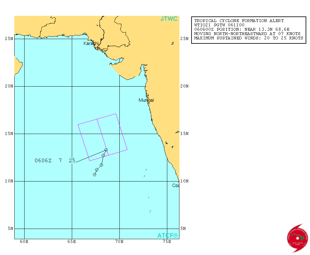
As per NRL: 95A.INVEST over the East Central Arabian Sea is located at 14.0°N & 68.5°E with 25 knots & 1004 mb. on 6th June 2015 @ 1230 UTC.
From JTWC:
ABIO10 PGTW 061130
MSGID/GENADMIN/JOINT TYPHOON WRNCEN PEARL HARBOR HI//
SUBJ/SIGNIFICANT TROPICAL WEATHER ADVISORY FOR THE INDIAN OCEAN
/REISSUED/061130Z-061800ZJUN2015//
REF/A/MSG/JOINT TYPHOON WRNCEN PEARL HARBOR HI/061051Z JUN 15//
AMPN/TROPICAL CYCLONE FORMATION ALERT.//
RMKS/
1. NORTH INDIAN OCEAN AREA (MALAY PENINSULA WEST TO COAST OF AFRICA):
A. TROPICAL CYCLONE SUMMARY: NONE.
B. TROPICAL DISTURBANCE SUMMARY:
(1) THE AREA OF CONVECTION PREVIOUSLY LOCATED NEAR 11.0N
67.6E, IS NOW LOCATED NEAR 13.3N 68.6E, APPROXIMATELY 415 NM
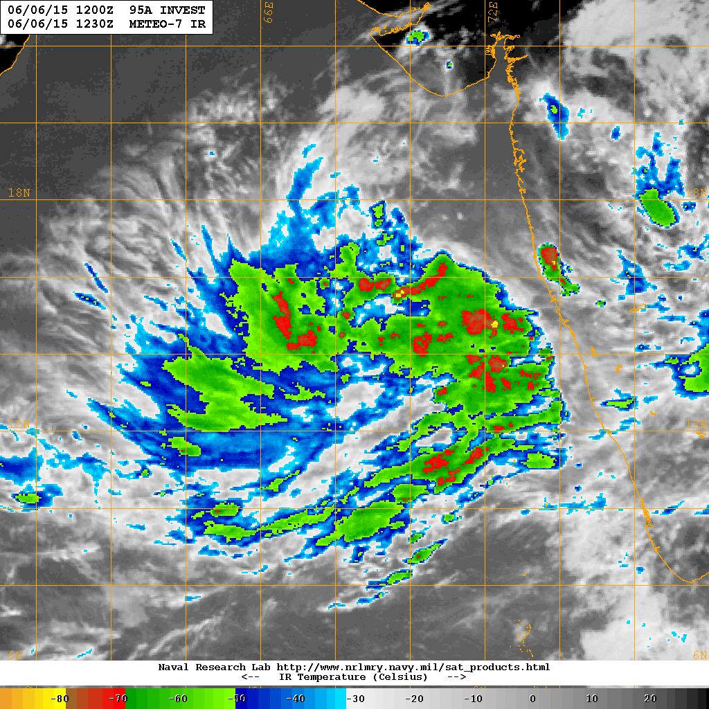
SOUTHWEST OF MUMBAI, INDIA. ANIMATED INFRARED SATELLITE IMAGERY
CONTINUES TO DEPICT A BROAD AREA OF PERSISTENT DEEP CONVECTION WITH
FORMATIVE BANDING WRAPPING INTO A SLOWLY-CONSOLIDATING LOW-LEVEL
CIRCULATION CENTER (LLCC). A 051433Z SSMIS MICROWAVE IMAGE REVEALS
FRAGMENTED CONVECTIVE BANDING AROUND THE LLCC. UPPER-LEVEL ANALYSIS
INDICATES THE DISTURBANCE IS LOCATED IN A FAVORABLE ENVIRONMENT WITH
LOW VERTICAL WIND SHEAR AND GOOD POLEWARD OUTFLOW. ADDITIONALLY,
WARM SEA SURFACE TEMPERATURES (29 TO 30 DEGREES CELSIUS) AND HIGH
OCEAN HEAT CONTENT VALUES ARE CONDUCIVE FOR DEVELOPMENT. THIS SYSTEM
IS EXPECTED TO TRACK GENERALLY NORTHWARD OVER THE NEXT TWO DAYS
ALONG THE WESTERN PERIPHERY OF THE POLEWARD ORIENTED SUBTROPICAL
RIDGE. MAXIMUM SUSTAINED SURFACE WINDS ARE ESTIMATED AT 20 TO 25
KNOTS. MINIMUM SEA LEVEL PRESSURE IS ESTIMATED TO BE NEAR 1004 MB.
THE POTENTIAL FOR THE DEVELOPMENT OF A SIGNIFICANT TROPICAL CYCLONE
WITHIN THE NEXT 24 HOURS IS UPGRADED TO HIGH. SEE REF A (WTIO21 PGTW
061100) FOR FURTHER DETAILS.
(2) NO OTHER SUSPECT AREAS.
2. SOUTH INDIAN OCEAN AREA (135E WEST TO COAST OF AFRICA):
A. TROPICAL CYCLONE SUMMARY: NONE.
B. TROPICAL DISTURBANCE SUMMARY: NONE.
3. JUSTIFICATION FOR REISSUE: UPGRADED AREA IN 1.B.(1) TO HIGH.//
NNNN
JTWC Map Showing Forecast Track For 95A.INVEST (TCFA)
NRL IR Satellite Image on 6th June 2015 @ 1230 UTC ( 06.00 pm. IST)
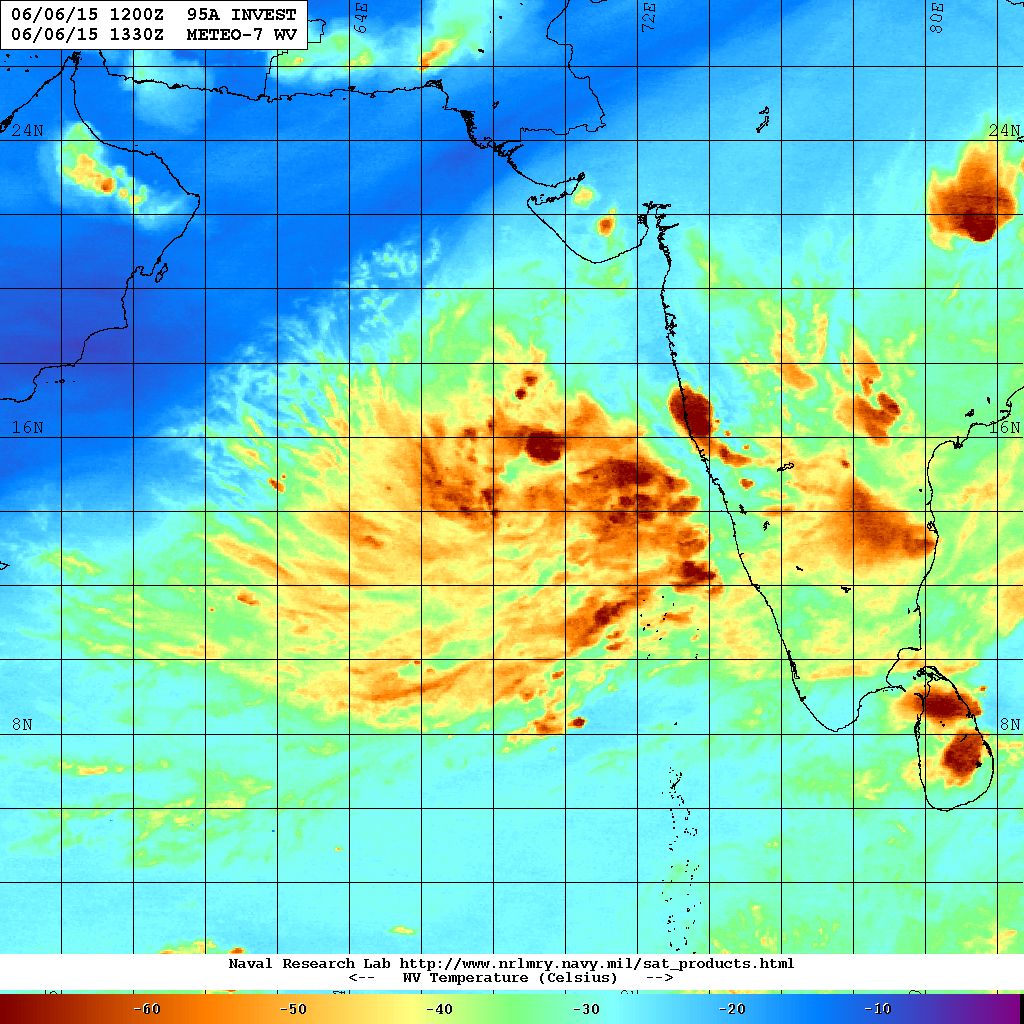
NRL Water Vapor Satellite Image on 4th June 2015 @ 1330 UTC ( 07.00 pm. IST)
Caution:
Please refer/rely on IMD/RSMC Bulletins/Advisories for Storms & Weather related matter.
સાવચેતી:
સ્ટોર્મ કે હવામાન અંગે ની માહિતી માટે ભારતીય હવામાન ખાતા/ગવર્મેન્ટ ના બુલેટીન/સુચના પર નિર્ભર રહેવું.
junagadh jila ma varsad ketlo thase?
System adharit varsad ma kai nakki na rahe.
As per imd this system turn into depresson
Update jovo
Sir lopreshar&we’ll marked lopreshar ma Shu difranc hoy
Thodu vadhare majboot ganay
Sir as per IMD, A depression has formed over eastcentral Arabian Sea and lay centred at 0830 hours IST of today, the 07th June, 2015 near latitude 14.50 N and longitude 68.50 E, about 690 km southwest of Mumbai, 740 km south-southwest of Veraval and 1230 km southeast of Masirah Island (Oman). It would move north-northwestwards and intensify further into a deep depression during next 24 hrs.
Updated
dear ashokbhai namskar.hu roj tamari coment vanchu chu.sir aa sistam thi s.nagar ma varsad thase.plese replay.
System adharit condition ma kai nakki na rahe.
Wow. As per Dundee satellite images low pressure is coming closer to Gujarat coast.
Jay shi krishna ashok bhai aaj sanj sudhi ma d pressure vishe kai update thay sake?
update thayu chhe
Respected sir,
does this low pressure draw the moisture of the sea and effect the rainfall activity on western india region?
Yes for extreme South India
12 /6/2016 na manavadar ma marriage chhe.
Varsad ni shakyata ketali?
50% 50%
Sir Gujarat ma a sistam thi asar thase?ane te north northwest gati Kare se te pramane varsad ni ketala taka analysts se
Jamnagar ma kedi aavse varshad aaj to 45 c pochiyu che
Sri aa low presuuer. D presuuer ma pari vatan thai gayu to have e cayclon ma pari vartan thay che evu lagi rha yu che 6 ne. . . . Pls riplay me
Bhartiya havaman khatu aane haju Well Marked Low Pressure kahe chhe.
Sir as sistam thi morbi ma vavni kayak varsad aaaavse.su thase..pls ans me
varasad avashe pan vavani layak thaay ke nahi te nakki na hoi.
Hello sir a system gujarat ma nahi Ave evu sure kahi sakay
chokkas kai nathi hotu. fer far thaya kare. update joya karo.
Sorry sir
dear sir aa low presure gujarat ni costal area pasethi pasar thase?ane jo thay to cyclone na form ma hoy toj rain aavse?tamaro andaj su kahe 6?biju sir track ma j pink middle line 6 te baju move thase ae perfect k aema ferfar thai sake?
Dar 6 kalake navo andaaj ave . Fer far thai shake.
Rain ni shakyata chhe. Track dar six hours na update thashe etle badli shake.
આભાર સર
નમસ્તે સર,
1 લો પ્રેસર 2 વેલ માર્ક લો પ્રેસર 3 ડિપ્રેસન 4 ડિપ ડિપ્રેસન 5 સાઇક્લોન
ચક્રવાત માટે આ ક્રમ બરાબર છે ?
Barobar chhe.
System gujarat thi ketli dur chhe ?
Aashare 650 Kms. Dakshin Dakshin Pashchime
Ashok Bhai Aaj To Low Pressure “D” Pressure Ban Gya he ,Sindhi mein Barish ka He K Nahe .
Majboot hua hey.
According to its track it would not touch the surface of Gujarat. It could pass away from Gujarat, in that situation if it becomes a cyclones, do u see cyclone clouds give rain to costal areas of Gujarat when it will go north West from Gujarat.
Yes.
kodinar ma vavni layak varsad kyare pad6 ?
Aa System thi varsad avashe. ketlo te nakki na rahe. System ni direction pramane aadhar chhe.
Dear sir,
I know me tame 1 week sushi j agahi karo cho pan maro que. E che k yahoo weather na app ma avta guruvar thi ravivar sushi varsad ni sakyata sari batave che .what u say sir pls..reply..s
Badha weather application alag alag batave chhe. Teo ne alag alag forecast model aadharit Application hoi chhe. Vishesh te babat ni maari paase koi tipani nathi.
Inset ma low presser gujrat ni najik avtu dekhay chhe..???
Map ma batave chhe kai baju jaay chhe te.
sir aa sistam. cayklon ma parivartit. tase
Cyclone pahela Depression thaay. Haju Depression thava diyo.
hello sir arabian sea low presser thi sw moonson asar karse agal vadhta??
Gujarat ne haal faydo chhe. Je ave te Bonus.
“Jun 06, 2015”
As of Saturday morning, EDT, a tropical area of low pressure is ……
*
Moderator Note: Vipulbhai…..Baaki nu delete karel chhe. Ahi ghana mitro gote chade chhe ane kyarek te mari agahi chhe teju samje chhe.
Jay sri krishna ashok sir pink box ma ek.line pashi 25 lakhel she to te knots she ke biju kai she ke aa baju low pressure gati karse ?
Aape saro prashna karyo ane badhane labh thashe. Pink box ma je center line chhe te disha batave chhe aagahi kay baju jaay chhe. 25 lakhel chhe te pavan ni speed batave chhe je knots ma hoi chhe. 1 knot=1.85 KM. etle aashare 45 Km. ni pavan ni zadap chhe. International model vara 1 minute ni sharerash pavan ni zadap pramane calculate kare chhe. Bhartiya havaman khatu te 3 minute ni sharerash pramane calculate kare chhe. 25 ni pahela 0606z ane 7 lakhel chhe. 0606z etle 6th June ane 0600 UTC etle 11.30 IST time. 7 chhe te System ketli… Read more »
Sir aa ek cyclone bane to pavan ni zadap aprroxmetly ketli thai sake che
Vavazoda maate 65 Kms. prati kalak ni pavan ni zadap ( 3 minute ave. wind speed basis) ochha ma ochhi hoi chhe
Sir a system gujrat ma avi sake
JTWC Map apel chhe tema pink box ma je line chhe te taraf haal andaj jawano chhe.
Sir what is reason behind or factors that Bob host more lows and cyclones than Arebian sea? Please answer
Google your question and you will get an answer to it.
You will learn much more by reading the details.
Sri aa low preesur vavajoda ma pari vartan thase ane jo thay to te su gujrat taraf fanta vani sakyata che su plz riplay me
JTWC Map apel chhe tema pink box ma je line chhe te taraf haal andaj jawano chhe.
Sir aa varsh 102% varsad padva ni aagahi api 6 su te sasu purvar thase tamaru su kevu 6
Means from now system will start to track nw….?
North Northwest direction.
Sir it will give patchy rain coz of clouds or storm but wht after that as I am following u from many years I have learn a bit from ur forecast sir it will take moisture after that so small or long break after that in rain?
It is a bonus for Gujarat. We were not going to get anything now. Whatever is raining from 5th June onwards over Gujarat is Bonus.
yes there will be brief gap for extreme South India.
Gujarat mate asarkarta raheshe
aagahi vancho
Sir it is written moving north east in the box.
So north east would indicate Gujarat ?
It moved North East. Now the pink box shows you forecast the direction. The center pink line is showing the direction
sir good evening sir can this system or would be “cyclone” come to Gujarat ?
Forecast track is given in map – centre line in the box.
Sir, what this pink box indicate in JTWC cyclone track forecast image?
Welcome Gaurav !
The Box shows the Forecast track.