30th July 2019
IMD Satellite Image
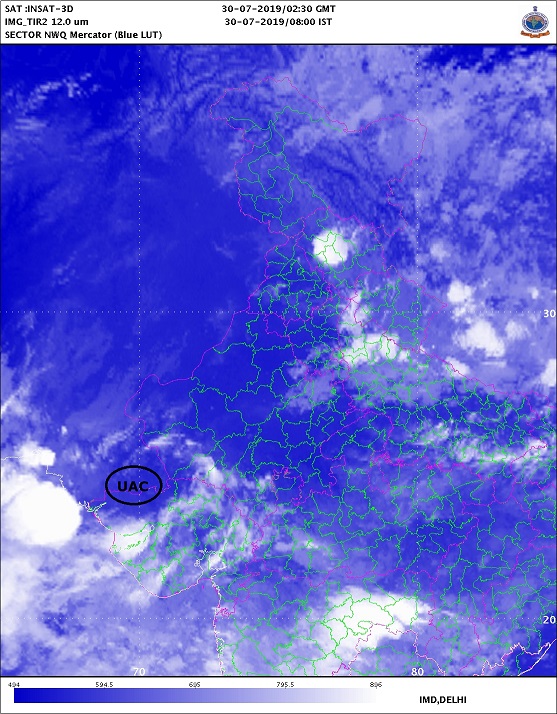
Current Weather Conditions on 29th July 2019
Some weather features from IMD :
The Monsoon Trough at mean sea level now passes through Jaisalmer, Bhilwara, Guna, Umaria, Pendra Road, Sambalpur, Chandbali and thence Southeastwards to Eastcentral Bay of Bengal extending up to 2.1 km above mean sea level.
The Cyclonic Circulation over Northwest Bay of Bengal & neighborhood extending up to 7.6 km above mean sea level now lies over North Odisha & adjoining areas of Gangetic West Bengal and Jharkhand tilting Southwestwards with height.
The Cyclonic Circulation over central parts of Rajasthan now lies over South Rajasthan & neighborhood and extends up to 3.6 km above mean sea level tilting Southwestwards with height.
The Trough from Central parts of west Rajasthan to Northwest Bay of Bengal now runs from South Rajasthan to Odisha across Madhya Pradesh and North Chhattisgarh extending between 3.1 km up to 7.6 km above mean sea level tilting Southwards with height.
The Western Disturbance as a Cyclonic Circulation over North Pakistan and adjoining Jammu & Kashmir now lies over Jammu & Kashmir and neighborhood at 3.1 km above mean sea level with the Trough aloft with its axis at 5.8 km above mean sea level roughly along Long. 73°E to north of 32°N.
The Western Disturbance as a Cyclonic Circulation between 4.5 & 5.8 km above mean sea level over Afghanistan & neighborhood persists.
Saurashtra, Gujarat & Kutch: Current conditions
There is a shortfall of 55% rain till 29th July 2019 for Saurashtra & Kutch Region, while Gujarat Region has 28% Deficit till 29th July 2019. Kutch is a 81% shortfall from normal till 29th July 2019.
Forecast: 26th July to 31st July 2019
Note: I do not Forecast more than a week ( Referred to as Hu LGAKN in the blog comments)
Cloudy weather on most days of the balance forecast period. Wind speeds of 25 to 50 km at some times daily during the forecast period over different areas of Saurashtra, Kutch & Gujarat. Upper Air Cyclonic Circulation lies over South Rajasthan and adjoining areas of North Gujarat.
Forecast Dated 26th July is given here with rainfall figures for clarity:
South Gujarat some centers could receive 7.5 mm to 35 mm, some centers 35 mm to 65 mm while some places receiving more than 65 mm on some days of the forecast period. High rainfall centers could reach total of 200 mm Rainfall during the forecast period.
North Gujarat some centers could receive 7.5 mm to 35 mm, some centers 35 mm to 65 mm while some places receiving more than 65 mm on some days of the forecast period. Mainly during 28th-30th July. High rainfall centers could reach total of 200 mm Rainfall during the forecast period.
East Central Gujarat some centers could receive 7.5 mm to 35 mm, some centers 35 mm to 65 mm and Isolated centers receiving more than 65 mm on some days of the forecast period. High rainfall centers could reach total of 150 mm Rainfall during the forecast period.
Kutch could some centers could receive 7.5 mm to 35 mm, some centers 35 mm to 65 mm while some places receiving more than 65 mm on some days of the forecast period. Mainly during 28th-31st July. High rainfall centers could reach total of 150 mm Rainfall during the forecast period.
Saurashtra Districts of Surendranagar, Rajkot, Morbi, Jamnagar, Dev Bhumi Dwarka some centers could receive 7.5 mm to 35 mm, some centers 35 mm to 65 mm and Isolated centers receiving more than 65 mm on some days of the forecast period. Mainly during 28th-31st July.
Rest of Saurashtra Districts some centers could receive up to 7.5 mm, some centers 7.5 mm to 35 mm, and some centers 35 mm to 65 mm on some days of the Forecast period.
Note: There are chances of Forecast outcome differing from reality and would be reviewed at the end of forecast period.
સૌરાષ્ટ્ર, ગુજરાત અને કચ્છ: તારીખ 26 જુલાઈ થી 31 જુલાઈ 2019
29 જુલાઈ 2019 ની સ્થિતિ:
મોન્સૂન ધરી દરિયા લેવલ થી 2.1 કિમિ ની ઊંચાઈ સુધી છે અને સાથે બે યુએસી આ ધરી માં સામેલ છે(એક યુએસી દક્ષિણ રાજસ્થાન પર છે અને બીજું યુએસી નોર્થ ઓડિશા/પશ્ચિમ બંગાળ પર છે). હાલ આ ધરી જેસલમેર, ભીલવાડા, ગૂના , ઉમરીયા , સંબલપુર, ચાંદબલી અને ત્યાંથી મધ્ય પૂર્વ બંગાળ ની ખાડી સુધી લબાય છે.
નોર્થ ઓડિશા અને લાગુ પશ્ચિમ બંગાળ પર સાયક્લોનિક સર્ક્યુલેશન 7.6 કિમિ ના લેવલ સુધી નું છે. વધતી ઉચાઈએ દક્ષિણ પશ્ચિમ તરફ ઝુકે છે.
રાજસ્થાન વાળું સાયક્લોનિક સર્ક્યુલેશન હવે દક્ષિણ રાજસ્થાન અને લાગુ નોર્થ ગુજરાત પાર છે અને તે 3.6 કિમિ ની ઉચાઈએ સુધી ફેલાયેલ છે. વધતી ઉચાયે દક્ષિણ પશ્ચિમ તરફ ઝુકે છે.
દક્ષિણ રાજસ્થાન થી એક ટ્રફ દક્ષિણ રાજસ્થાન થી ઓડિશા સુધી 3.1 કિમિ થી 7.6 કિમિ ના લેવલ સુધી છે અને તે વધતી ઉંચાઈએ દક્ષિણ તરફ ઝુકે છે.
વેસ્ટર્ન ડિસ્ટર્બન્સ હાલ જમ્મુ અને કાશ્મીર અને આસપાસ ના વિસ્તાર માં છે 3.1 ની ઉંચાઈએ અને સાથે ટ્રફ 5.8 કિમિ જે 73°E અને 32°N. થી નોર્થ બાજુ.
વેસ્ટર્ન ડિસ્ટર્બન્સ 4.5 કિમિ થી 5.8 કિમિ ની ઉંચાઈએ યુએસી તરીકે છે જે અફઘાનિસ્તાન અને આસપાસ ના વિસ્તાર પર છે.
સૌરાષ્ટ્ર કચ્છ વિસ્તાર માં 29 જુલાઈ સુધી માં વરસાદ ની 55% ની ઘટ રહી છે જયારે ગુજરાત વિસ્તાર માં 28% ઘટ રહી છે. એકલા કચ્છ માં 81% ઘટ છે.
આગાહી: 26 જુલાઈ થી 31 જુલાઈ 2019
નોંધ: હું એક અઠવાડિયા થી વધુ ની આગાહી કરતો નથી. Hu LGAKN એટલે હું લાંબા ગાળા ની આગાહી કરતો નથી !
આગાહી ના બાકી ના દિવસો માં અવાર નવાર વાદળ છાયું વાતાવરણ તેમજ બહુ તેઝ પવનો દર રોજ અમુક ટાઈમે વધી ને 25 કિમિ થી 50 કિમિ પ્રતિ કલાક સુધી ફૂંકાશે. અપાર એર સાયક્લોનિક સર્ક્યુલેશન હવે દક્ષિણ રાજસ્થાન અને લાગુ નોર્થ ગુજરાત આસપાસ ના વિસ્તાર માં છે.
26 જુલાઈ ની આગાહી અહીં ચોખવટ માટે વરસાદ ના આંકડા સહીત લખી છે.
દક્ષિણ ગુજરાત માં આગાહી ના અમુક દિવસો કોઈ સેન્ટર માં 7.5 mm થી 35 mm, કોઈ સેન્ટર માં 35 mm થી 65 mm અને અમુક સેન્ટર માં 65 mm થી વધુ વરસાદ ની શક્યતા. આગાહી દરમિયાન વધુ વરસાદ વાળા અમુક સેન્ટરો માં કુલ વરસાદ 200 mm. સુધી પહોંચે.
નોર્થ ગુજરાત માં આગાહી ના અમુક દિવસો કોઈ સેન્ટર માં 7.5 mm થી 35 mm, કોઈ સેન્ટર માં 35 mm થી 65 mm અને અમુક સેન્ટર માં 65 mm થી વધુ વરસાદ ની શક્યતા. મુખ્ય વરસાદ 28 થી 30 જુલાઈ દરમિયાન. આગાહી દરમિયાન વધુ વરસાદ વાળા (અમુક) સેન્ટરો માં કુલ વરસાદ 200 mm. સુધી પહોંચે.
મધ્ય પૂર્વ ગુજરાત માં આગાહી ના અમુક દિવસો કોઈ સેન્ટર માં 7.5 mm થી 35 mm, કોઈ સેન્ટર માં 35 mm થી 65 mm અને એકલ દોકલ સેન્ટર માં 65 mm થી વધુ વરસાદ ની શક્યતા. આગાહી દરમિયાન વધુ વરસાદ વાળા (અમુક) સેન્ટરો માં કુલ વરસાદ 150 mm. સુધી પહોંચે.
કચ્છ માં આગાહી ના અમુક દિવસો કોઈ સેન્ટર માં 7.5 mm થી 35 mm, કોઈ સેન્ટર માં 35 mm થી 65 mm અને અમુક સેન્ટર માં 65 mm થી વધુ વરસાદ ની શક્યતા. મુખ્ય વરસાદ 28 થી 31 જુલાઈ દરમિયાન. આગાહી દરમિયાન વધુ વરસાદ વાળા (અમુક) સેન્ટરો માં કુલ વરસાદ 150 mm. સુધી પહોંચે.
સૌરાષ્ટ્ર ના સુરેન્દ્રનગર, રાજકોટ, મોરબી, જામનગર, દેવ ભૂમિ દ્વારકા જિલ્લા માં આગાહી ના અમુક દિવસો કોઈ સેન્ટર માં 7.5 mm થી 35 mm, કોઈ સેન્ટર માં 35 mm થી 65 mm અને એકલ દોકલ સેન્ટર માં 65 mm થી વધુ વરસાદ ની શક્યતા. મુખ્ય વરસાદ 28 થી 31 જુલાઈ દરમિયાન.
સૌરાષ્ટ્ર ના બાકી ના જિલ્લાઓ માં આગાહી ના અમુક દિવસો કોઈ સેન્ટર માં 7.5 mm સુધી તો કોઈ સેન્ટર માં 7.5 mm થી 35 mm અને કોઈ સેન્ટર માં 35 mm થી 65 mm.
નોંધ: આગાહી આપેલ વરસાદ ની માત્રા અને આગાહી સમય પૂરો થાય ત્યાં સુધી નો જે વરસાદ થાય તેમાં વધ ઘટ ની શક્યતા છે. તેનું મૂલ્યાંકન આગાહી સમય પછી થશે.
Caution: Please refer/rely on IMD/RSMC Bulletins/Advisories for Storms & Weather related matter.
સાવચેતી:
સ્ટોર્મ કે હવામાન અંગે ની માહિતી માટે ભારતીય હવામાન ખાતા/ગવર્મેન્ટ ના બુલેટીન/સુચના પર નિર્ભર રહેવું.
Click the links below. Page will open in new window
Read Forecast In Akila Daily Dated 27th July 2019
Read Forecast in Sanj Samachar Daily Dated 26th July 2019
Read Forecast In Akila Daily Dated 26th July 2019
ઉપર ની બધી અલગ લિન્ક ક્લિક કરો. નવી વિન્ડો માં પેજ ખૂલશે
Sir amare chorvad baju 1 week thi tadko nthi nikdto to aa ek karan hoy sake varsad no avanu.
Tadko praman ma ochho nikadyo chhe Saurashtra ma.
Sir, ventusky par tamaro bharoso ketla taka chhe?
Te International Website chhe
Model ma ICON and GFS and GEM … em tran hoy chhe.
model select Automatic thay.. temaj aagad na divaso ma GFS thai jaay. chhe.
Jovanu badhu
Sir arvalli ma rat no dhimi dhare varsad chalu hato Aaje bapore 2 vagya thi bandh che to have vadhu varsad no chance khro Amare? Plz ans aapjo
સર અમારે વાવણી થી માંડી અત્યાર સુધી નો કુલ
10થી 12 ઇંચ વરસાદ છે પણ હજી ક્યાંય નાનું ખાબોચિયું પણ ભરાનું નથી એટલે એક ઝલક જોરદાર થઈ જાય તો સારું….
Sir,,, shear zone active che avta 24/48 kalak mate ???k nablu padyu che….
Trough thodu North baju gayu chhe.
sir 2 divas pahela satellite ma vadda nta dekhata toy varsad aavto hto aje dekhay che toy nathi aavto.
Good
Sir dar vakhte mp baju thi systam save chhe teno Labh kem malato Nathi matr dhimi share j save chhe
Aane ochho laabh na kahevaay.
Sir Maliya miyana taluka ma varsad ochho chho se vadhare varsad kiyare avse
Apdet to aavi gay headline to sir ????
નવી અપડેટ મેળવવા સૌથી પહેલુ માધયમ કયૂ
Ahi update original samjavi. English and Gujarati banne lakhvu pade etle var lage. Chhapa ma toe vat thai gai etle update thai gai !
Sir chomasu dhari uttar taraf jai rahi chhe?
સર અમારે અખો દિવસ કાળા ડીબાંગ વાદળો વાળું વાતાવરણ રહ્યું, વરસાદ ઝરમર જ આવ્યો, સર આગળ કેમ રેહ છે
ગામ લુણગરી
તાલુકો જેતપુર
Akila ma update aavi ne saheb