Current Weather Conditions on 24th June 2018
As per IMD :Southwest monsoon has further advanced into some parts of north Arabian Sea, Saurashtra & some more parts of Gujarat region and Maharashtra; some parts of West Madhya Pradesh, some more parts of West Bengal and remaining parts of Assam. The Northern Limit of Monsoon passes through Lat. 21°N/ Long. 60°E, Lat. 21°N/ Long. 65°E, Veraval, Amreli, Ahmedabad, Khandwa, Amravati, Gondia, Titlagarh, Cuttack, Midnapore, Lat. 24°N/ Long. 89°E, Jalpaiguri and Lat. 27°N/ Long. 87°E.
Conditions are becoming favourable for further advance of Southwest Monsoon into some more parts of north Arabian Sea, Gujarat State; remaining parts of Maharashtra; some more parts of Madhya Pradesh, Chhattisgarh,; remaining parts of Odisha, West Bengal and some parts of Jharkhand and Bihar during next 48 hours.
Conditions are likely to become favourable for further advance of Southwest Monsoon into some more parts of north Arabian Sea, remaining parts of Madhya Pradesh, Chhattisgarh and some parts of Uttar Pradesh during subsequent 48 hours.
Pre-monsoon thunderstorm activity is very likely to commence over parts of northwest India from 27 June.
IMD Advance Of Southwest Monsoon Map (click ‘Latest Advance for Latest Map)
Advance till 24-06-2018
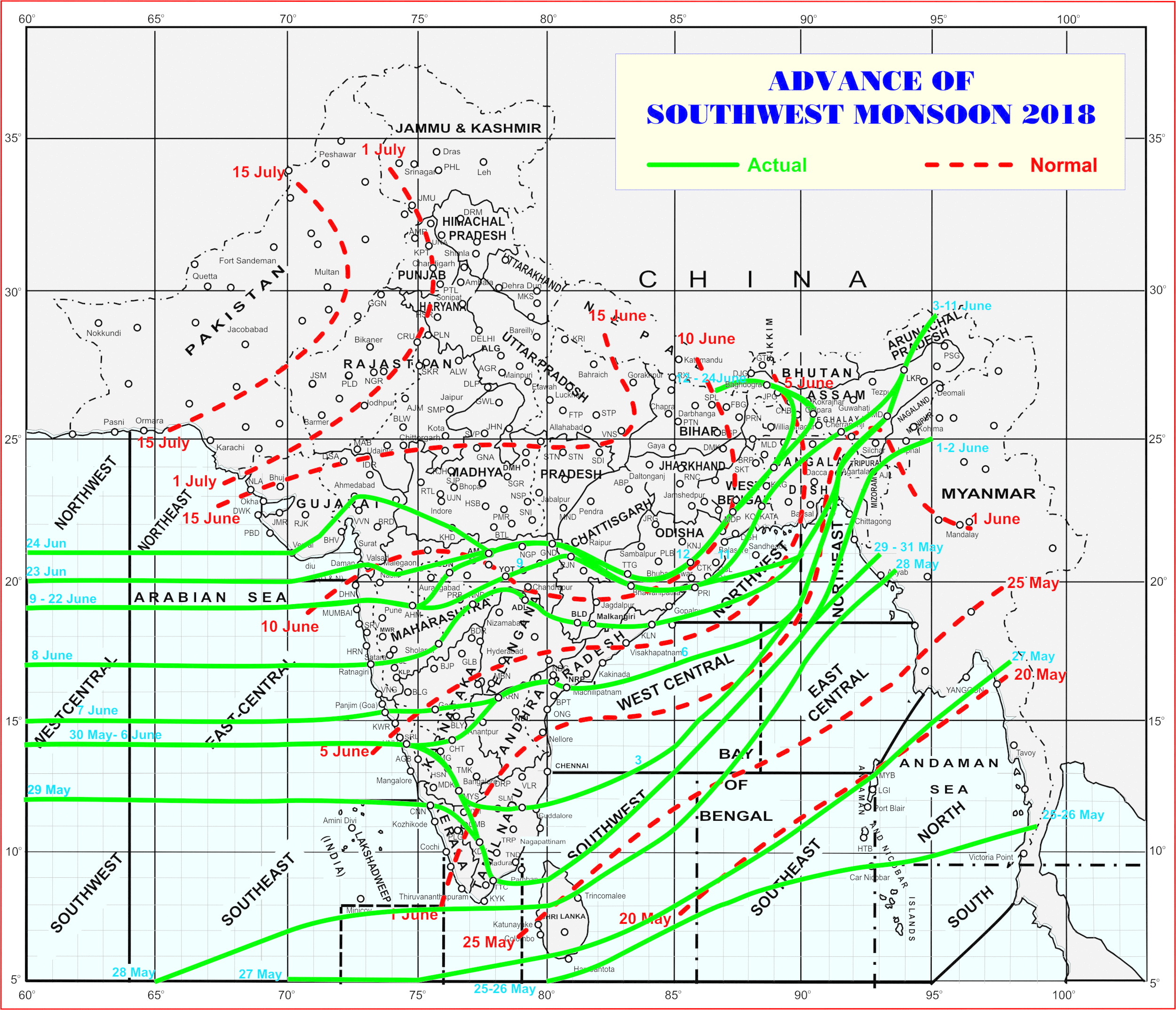
Latest Advance Map

Advance till 24-06-2018
Latest Advance Map
સૌથી ઉપર ની લીલી લીટી ના છેડે જે તારીખ હોઈ તે તારીખે લીટી ની નીચે ના ભાગ માં બધે ચોમાસું પોંચી ગયું છે તેમ સમજવું.
લાલ ત્રુટક લીટી જે તે વિસ્તાર માં નોર્મલ ચોમાસું બેસવાની તારીખ દર્શાવે છે
The date shown at the end of green line shows that the Southwest Monsoon has set in over areas below the green line on that date.
The red dashed line shows the normal date of onset of Southwest Monsoon over various regions
નોંધ: રેગ્યુલર અપડેટ 25 તારીખે છે.
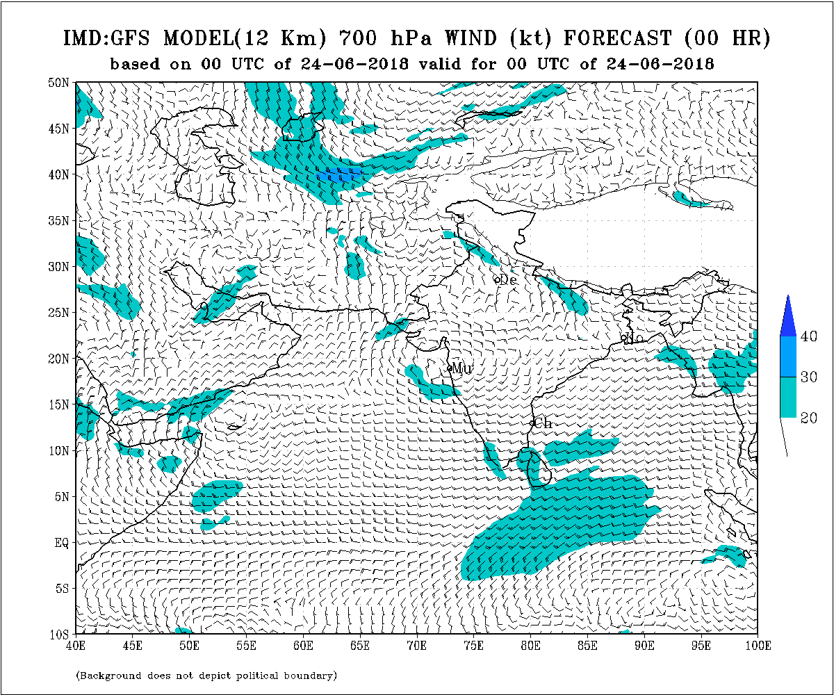
મોન્સૂન ઑફ-શોર ટ્રફ દરિયાની સપાટી ના લેવલ માં દક્ષિણ ગુજરાત થી કેરળ સુધી છે
એક યુએસી 700 hPa ઉપર છે દક્ષિણ ગુજરાત અને નોર્થ કોંકણ અને લાગુ લાગુ અરબી સમુદ્ર ઉપર.
ઇસ્ટ વેસ્ટ શિયર ઝોન છે 20N લેટીટ્યુડ ઉપર જે મહારાષ્ટ્ર/એમપી, સૌરાષ્ટ્ર/ગુજરાત અને અરબી સમુદ્ર માં સામ સામા પવનો નું સર્કુલેસન છે.
વાતાવરણ 22 જૂન થી સુધારો જોવા મળેલ છે. ચોમાસુ આજે 24 જૂન ના સૌરાષ્ટ્ર ના દક્ષિણ કાંઠા ના વિસ્તાર વેરાવળ થી લઇ ને અમરેલી થી અમદાવાદ સુધી પહોંચ્યું. હવે 2-3 દિવસ માં સૌરાષ્ટ્ર ના વધુ ભાગો માં આગળ ચાલે તેવી શક્યતા છે. ચોમાસુ ગુજરાત બાજુ વધુ આગળ ચાલી ગયું અને પશ્ચિમ સૌરાષ્ટ્ર બાજુ ઓછું ચાલ્યું જે ચોમાસુ રેખા માં સ્પષ્ટ દેખાય છે. હજુ વાવરણ સારું છે.
Current Situation and Conclusions:
The is an Off-shore Monsoon trough at sea level now runs along South Gujarat to Kerala Coast.
There is a UAC at 700 hPa over South Gujarat & North Konkan & adjoining Arabian Sea.
The East-West shear zone runs roughly along latitude 20.0°N over Indian region at 3.1 km above
mean sea level. The shear zone covers Maharashtra adjoining M.P. and Arabian sea and Saurashtra/Gujarat.
Saurashtra, Gujarat & Kutch: Next update 25th June 2018
Southwest Monsoon has onset today the 24th June over South Saurashtra, East Saurashtra, South Gujarat, East Gujarat up to Ahmedabad. Varying amounts of rainfall has been reported. The Southwest Monsoon has not moved over Western Saurashtra and has lagged behind Gujarat and East Saurashtra. Conditions are yet favorable for rain.
Caution: Please refer/rely on IMD/RSMC Bulletins/Advisories for Storms & Weather related matter.
સાવચેતી:
સ્ટોર્મ કે હવામાન અંગે ની માહિતી માટે ભારતીય હવામાન ખાતા/ગવર્મેન્ટ ના બુલેટીન/સુચના પર નિર્ભર રહેવું.