Current Weather Conditions on 25th June 2018
As per IMD :
Southwest monsoon has further advanced into some more parts of Odisha, most parts of West Bengal and some parts of Bihar and Jharkhand. The Northern Limit of Monsoon passes through Lat. 21°N/ Long. 60°E, Lat. 21°N/ Long. 65°E, Veraval, Amreli, Ahmedabad, Khandwa, Amravati, Gondia, Titlagarh, Angul, Jamshedpur, Supaul and Lat. 27°N/ Long. 86°E, .
Conditions are becoming favourable for further advance of Southwest Monsoon into some more parts of north Arabian Sea, Gujarat State; remaining parts of Maharashtra; some more parts of Madhya Pradesh, Chhattisgarh; remaining parts of Odisha, West Bengal, some more parts of Jharkhand and Bihar and some parts of East Uttar Pradesh and south east Rajasthan during next 48 hours.
Conditions are likely to become favourable for further advance of Southwest Monsoon into remaining parts of Madhya Pradesh, Chhattisgarh, Bihar & Jharkhand and some more parts of Uttar Pradesh during subsequent 48 hours.
Premonsoon thunderstorm activity is very likely to commence over parts of northwest India from 26 June.
Subsequently, advance of southwest monsoon is also likely over parts of northwest India including Delhi during 28th June1st July.
IMD Advance Of Southwest Monsoon Map (click ‘Latest Advance for Latest Map)
Advance till 25-06-2018
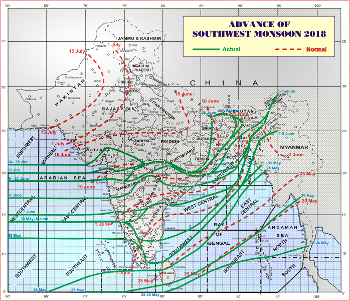
Latest Advance Map

Advance till 25-06-2018
Latest Advance Map
સૌથી ઉપર ની લીલી લીટી ના છેડે જે તારીખ હોઈ તે તારીખે લીટી ની નીચે ના ભાગ માં બધે ચોમાસું પોંચી ગયું છે તેમ સમજવું.
લાલ ત્રુટક લીટી જે તે વિસ્તાર માં નોર્મલ ચોમાસું બેસવાની તારીખ દર્શાવે છે
The date shown at the end of green line shows that the Southwest Monsoon has set in over areas below the green line on that date.
The red dashed line shows the normal date of onset of Southwest Monsoon over various regions
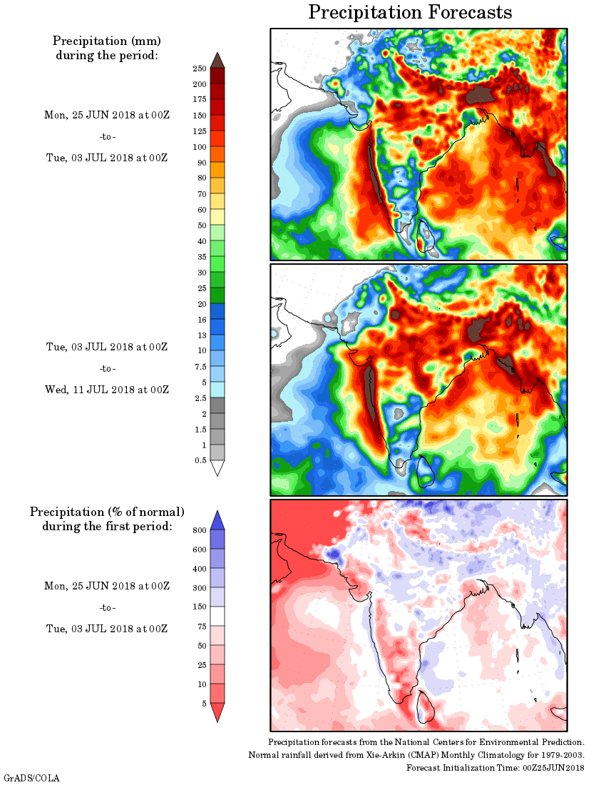
હાલ ની પરિસ્થિતિ અને નિચોડ:
ઓફશોર ટ્રફ દક્ષિણ ગુજરાત થી કેરળ સુધી સી લેવલ ઉપર છે.
એક યુએસી દક્ષિણ દક્ષિણ ગુજરાત/નોર્થ કોંકણ ઉપર બહોળા વિસ્તાર માં છે જે 3.1 કિમિ ની ઊંચાઈ સુધી ફેલાયેલ છે.
એક યુએસી 0.75 કિમિ ની ઊંચાઈ સુધી સેન્ટ્રલ યુ.પી. આસપાસ છે.
સૌરાષ્ટ્ર, ગુજરાત અને કચ્છ: તારીખ 25 જૂન થી 2 જુલાઈ 2018
24 જૂન ના સૌરાષ્ટ્ર ના દક્ષિણ કાંઠા ના વિસ્તાર વેરાવળ થી લઇ ને અમરેલી થી અમદાવાદ સુધી પહોંચ્યું. ચોમાસુ ગુજરાત બાજુ વધુ આગળ ચાલી ગયું અને પશ્ચિમ સૌરાષ્ટ્ર બાજુ ઓછું ચાલ્યું જે ચોમાસુ રેખા માં સ્પષ્ટ દેખાય છે.
વિવિધ ફોરકાસ્ટ મોડલ વચ્ચે મોટો મતમતાંતર છે. હાલ GFS મોડલ મુજબ વરસાદ થયેલ છે. આજની આગાહી ની વિશ્વનીયતા દરેક વખત કરતા ઓછી સમજવી.
ચોમાસુ સૌરાષ્ટ્ર ના હજુ થોડા ભાગો માં પહોંચ્યું છે જેથી ગુજરાત કરતા વરસાદ ની માત્રા ઓછી રહેશે.
દક્ષિણ ગુજરાત, મધ્ય ગુજરાત અને નોર્થ ગુજરાત માં કુલ વરસાદ 10 સેન્ટિમીટર અને વધુ આગાહી સમય દરમ્યાન. જોકે કચ્છ ને લાગુ નોર્થ ગુજરાત માં માત્રા 10 સેન્ટિમીટર થી ઓછી.
50% સૌરાષ્ટ્ર માં 4 થી 8 સેન્ટિમીટર આગાહી સમય દરમિયાન કુલ વરસાદ.
બાકી ના 50% સૌરાષ્ટ્ર અને કચ્છ માં ઝાપટા થી લઇ ને 4 સેન્ટિમીટર સુધી વરસાદ આગાહી સમય દરમિયાન.
નોંધ: આ આગાહી ઉપર મદાર રાખી ને કોરા માં વાવવું નહિ.
Current Situation and Conclusions:
The is an Off-shore Monsoon trough at sea level now runs along South Gujarat to Kerala Coast.
There is a UAC as a broad circulation at 3.1 km above mean sea level over South Gujarat/North Konkan and adjoining areas.
There is a UAC over Central U.P. and adjoining areas at 0.75 km above mean sea level.
Saurashtra, Gujarat & Kutch: 25th June to 2nd July 2018
The Southwest Monsoon entered Saurashtra yesterday. The NLM line passes though 21N, Veraval, Amreli & Ahmedabad and then towrds Khandwa in Madhya Prasdesh. Refer Map above. The rain quantum may not be evenly distributed over the areas where monsoon has on set over Saurashtra, since IMD has a criteria to draw continuous NLM line for areas of Monsoon onset.
Various forecast models have differing outcome and today’s forecast has lower confidence of the outcome. Currently GFS is performing better than other forecast models in last few days.
South Gujarat, Central Gujarat & North Gujarat will receive cumulative more than 10 cms. rainfall during the forecast period. Areas of North Gujarat adjoining Kutch can receive lower quantum of rainfall.
Monsoon has not yet covered significant areas of Saurashtra so rain quantum would be much lower than Gujarat side.
50% Saurashtra is expected to receive 4 to 8 cms. cumulative during the forecast period.
Balance 50% Saurashtra & Kutch will get Scattered showers/light rain on lower side and up to 4 cms. during the forecast period.
Note: Saurashtra/Kutch refrain from sowing without rain.
Caution: Please refer/rely on IMD/RSMC Bulletins/Advisories for Storms & Weather related matter.
સાવચેતી:
સ્ટોર્મ કે હવામાન અંગે ની માહિતી માટે ભારતીય હવામાન ખાતા/ગવર્મેન્ટ ના બુલેટીન/સુચના પર નિર્ભર રહેવું.