Introducing: The KOLA Indian Ocean Dipole (IOD) Index
નવીનત્તમ પ્રસ્તુતિ: KOLA ઇન્ડિયન ઑસન ડાયપોલ (IOD) ઈન્ડેક્સ
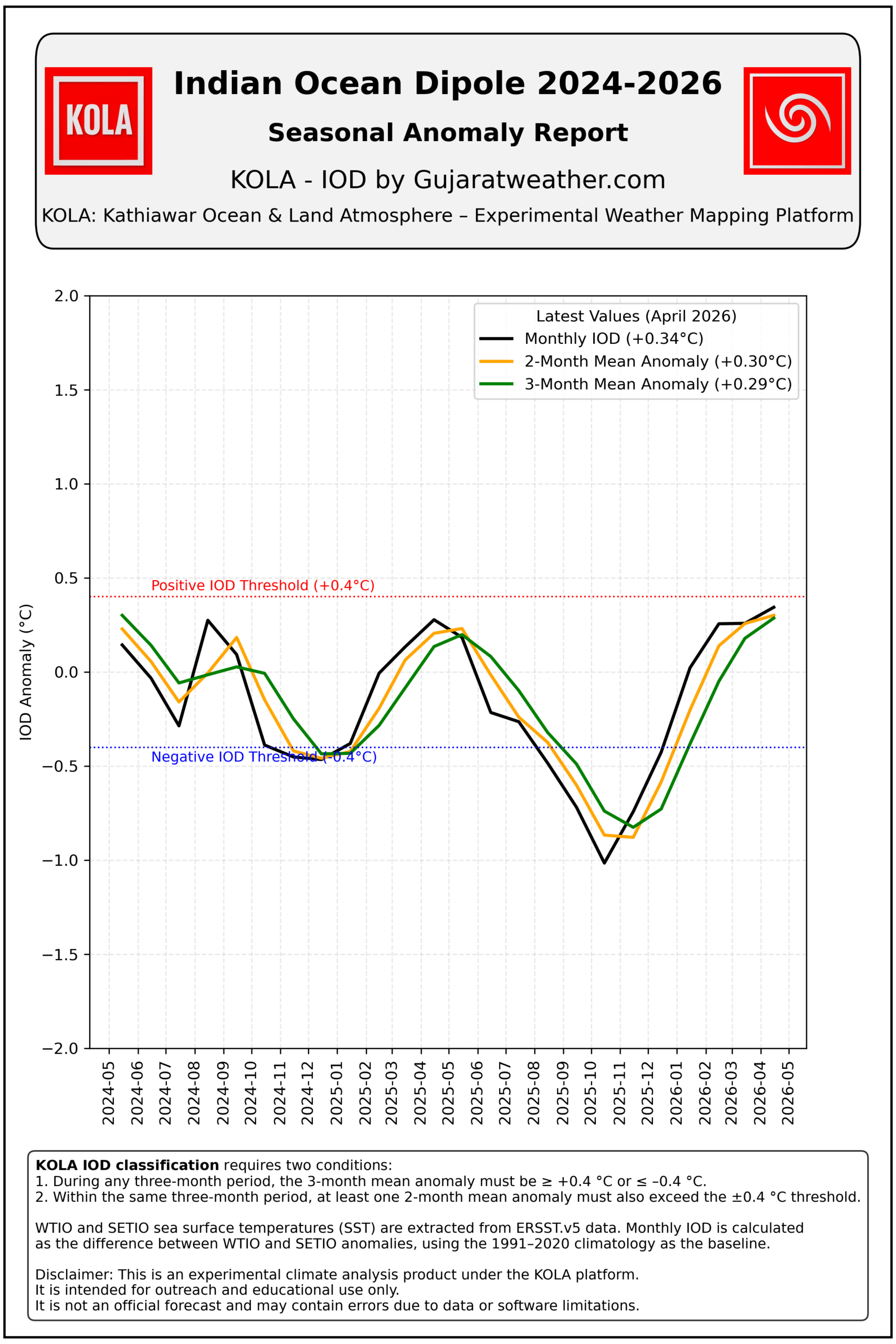
Date: 20-05-2026
The Indian Ocean Dipole (IOD) is one of the most important climate patterns influencing weather across the Indian Ocean region. It is determined by the difference in sea surface temperature (SST) anomalies between two key areas:
- Western Tropical Indian Ocean (WTIO): 50°E–70°E, 10°S–10°N
- Southeastern Tropical Indian Ocean (SETIO): 90°E–110°E, 10°S–0°N
A positive DMI develops when sea surface temperature anomalies over the Western Tropical Indian Ocean (WTIO) are significantly warmer relative to those over the Southeastern Tropical Indian Ocean (SETIO). When this pattern is sufficiently strong and sustained, it is classified as a positive IOD event. This pattern generally strengthens the Indian Summer Monsoon and increases rainfall over many parts of India.
A negative DMI develops when sea surface temperature anomalies over the Western Tropical Indian Ocean (WTIO) are significantly cooler relative to those over the Southeastern Tropical Indian Ocean (SETIO). When this pattern is sufficiently strong and sustained, it is classified as a negative IOD event. This pattern generally weakens the Indian Summer Monsoon and may contribute to below-normal rainfall over many parts of India.
The IOD also plays an important role in modulating the effects of the El Niño–Southern Oscillation (ENSO):
- A positive IOD can partially offset the adverse impact of El Niño on the Indian monsoon.
- A negative IOD can reinforce El Niño’s drying influence and increase the risk of deficient rainfall.
The KOLA IOD index is calculated using ERSST.v5 sea surface temperature data, with anomalies referenced to the 1991–2020 climatological baseline.
The KOLA Dipole Mode Index (DMI) is defined as:
DMI_{month}=Anom_{WTIO}-Anom_{SETIO}
where:
- AnomWTIO = Sea surface temperature (SST) anomaly over the Western Tropical Indian Ocean
- AnomSETIO = Sea surface temperature (SST) anomaly over the Southeastern Tropical Indian Ocean
Here, SST anomaly represents the departure of the observed sea surface temperature from the normal climatological SST.
An IOD event is identified only when the anomaly is both sufficiently strong and persistent. The KOLA methodology applies the following two conditions:
- The 3-month mean DMI must be ≥ +0.4°C for a positive IOD or ≤ –0.4°C for a negative IOD.
- Within the same 3-month period, at least one 2-month mean DMI must also exceed the ±0.4°C threshold.
This methodology ensures that only sustained and well-established IOD events are classified, while short-lived fluctuations are excluded.
The Australian Bureau of Meteorology (BOM) uses a similar, but slightly different, methodology to identify IOD events.
BOM Criteria
- The 12-week running mean DMI must exceed ±0.4°C.
- The anomaly must remain above the threshold for at least 8 consecutive weeks.
Key Differences
- BOM Method: Uses weekly data and 12-week smoothing, which can detect events earlier.
- KOLA Method: Uses monthly anomalies and seasonal averages, making it particularly suitable for climatological studies and monsoon analysis.
Although the methodologies differ in time scale and persistence rules, both are designed to identify sustained basin-wide ocean temperature anomalies that significantly influence regional climate and rainfall patterns.
The IOD is a critical factor in assessing the likely behavior of the Indian Summer Monsoon. In some years, a strong positive IOD has helped produce near-normal or above-normal rainfall over India despite the presence of El Niño. In contrast, a negative IOD can intensify El Niño’s adverse effects and increase the probability of below-normal monsoon rainfall.
Because of this close relationship, monitoring the IOD alongside ENSO provides valuable insight into seasonal rainfall prospects over India and neighboring regions.
નવીનત્તમ પ્રસ્તુતિ: KOLA ઇન્ડિયન ઑસન ડાયપોલ (IOD) ઈન્ડેક્સ
ઇન્ડિયન ઑસન ડાયપોલ (IOD) એ ઇન્ડિયન ઑસનમાં જોવા મળતી એક મહત્વપૂર્ણ આબોહવાની પ્રણાલી છે. તે બે મુખ્ય સમુદ્રી વિસ્તારોના સમુદ્ર સપાટી તાપમાન (SST) એનૉમલી વચ્ચેના તફાવત પર આધારિત છે:
-
-
-
- WTIO (વેસ્ટ ટ્રોપિકલ ઇન્ડિયન ઑસન): 50°E–70°E, 10°S–10°N
- SETIO (સાઉથઈસ્ટર્ન ટ્રોપિકલ ઇન્ડિયન ઑસન): 90°E–110°E, 10°S–0°N
-
-
એનૉમલી (Anomaly) નો અર્થ છે કોઈ મૂલ્યનું તેના નોર્મલ ક્લાઈમેટોલોજીકલ સરેરાશથી થયેલું વિચલન (departure).સમુદ્ર સપાટી તાપમાનની એનૉમલી (SST Anomaly) એટલે કોઈ વિસ્તારમાં નોંધાયેલ સમુદ્ર સપાટી તાપમાન (SST) અને તે વિસ્તારના નોર્મલ ક્લાઈમેટોલોજીકલ SST વચ્ચેનો તફાવત.
ગણિતીય રીતે:
SST Anomaly = Observed SST – Normal Climatological SST
ઉદાહરણ તરીકે:
-
-
- કોઈ મહિનાનું વાસ્તવિક SST = 29.2°C
- 1991–2020 નોર્મલ ક્લાઈમેટોલોજીકલ SST = 28.7°C
-
તો:
SST એનૉમલી = +0.5°C
અર્થાત્ તે મહિને સમુદ્ર સપાટી તાપમાન નોર્મલ કરતાં 0.5°C વધુ હતું.
તે જ રીતે:
-
-
- વાસ્તવિક SST = 27.9°C
- નોર્મલ SST = 28.4°C
-
તો:
SST એનૉમલી = –0.5°C
અર્થાત્ SST નોર્મલ કરતાં 0.5°C ઓછું હતું.
સરળ ગુજરાતી અર્થ: એનૉમલી એટલે નોર્મલ ક્લાઈમેટોલોજીકલ સરેરાશથી થયેલો તફાવત.
હાલના સંદર્ભમાં: સમુદ્ર સપાટી તાપમાનની એનૉમલી એટલે વાસ્તવિક SST અને નોર્મલ SST વચ્ચેનો તફાવત.
વેસ્ટ ટ્રોપિકલ ઇન્ડિયન ઑસન (WTIO) વિસ્તારમાં સમુદ્ર સપાટી તાપમાનની એનૉમલી સાઉથઈસ્ટર્ન ટ્રોપિકલ ઇન્ડિયન ઑસન (SETIO) વિસ્તારમાંની એનૉમલીની સરખામણીએ નોંધપાત્ર વધુ હોય ત્યારે DMI પોઝિટિવ બને છે. જ્યારે આ સ્થિતિ પૂરતી મજબૂત હોય અને જરૂરી સમયગાળા સુધી સતત ટકી રહે, ત્યારે તેને પોઝિટિવ IOD ઘટના તરીકે વર્ગીકૃત કરવામાં આવે છે. આવી સ્થિતિ સામાન્ય રીતે ભારતીય ગ્રીષ્મ ઋતુના ચોમાસાને મજબૂત બનાવે છે અને ભારતના ઘણા વિસ્તારોમાં વરસાદમાં વધારો કરે છે.
વિપરીત રીતે, વેસ્ટ ટ્રોપિકલ ઇન્ડિયન ઑસન (WTIO) વિસ્તારમાં સમુદ્ર સપાટી તાપમાનની એનૉમલી સાઉથઈસ્ટર્ન ટ્રોપિકલ ઇન્ડિયન ઑસન (SETIO) વિસ્તારમાંની એનૉમલીની સરખામણીએ નોંધપાત્ર ઓછી હોય ત્યારે DMI નેગેટિવ બને છે. જ્યારે આ સ્થિતિ પૂરતી મજબૂત હોય અને જરૂરી સમયગાળા સુધી સતત ટકી રહે, ત્યારે તેને નેગેટિવ IOD ઘટના તરીકે વર્ગીકૃત કરવામાં આવે છે. આવી સ્થિતિ સામાન્ય રીતે ભારતીય ગ્રીષ્મ ઋતુના ચોમાસાને નબળું બનાવે છે અને ભારતના ઘણા વિસ્તારોમાં નોર્મલથી ઓછા વરસાદની સ્થિતિમાં ફાળો આપી શકે છે.
IOD નો એલ નીનો–સધર્ન ઓસિલેશન (ENSO) સાથે પણ મહત્વપૂર્ણ સંબંધ છે:
-
-
- પોઝિટિવ IOD ઘણી વખત એલ નીનોની ચોમાસા પરની નકારાત્મક અસરને આંશિક રીતે ઘટાડે છે.
- નેગેટિવ IOD એલ નીનોની વરસાદી અછત વાળી અસરને વધુ મજબૂત બનાવી શકે છે.
-
KOLA IOD ઇન્ડેક્સ ERSST.v5 સમુદ્ર સપાટી તાપમાનના ડેટાનો ઉપયોગ કરીને તૈયાર કરવામાં આવ્યો છે. એનૉમલીની ગણતરી માટે 1991–2020 ક્લાઈમેટોલોજી આધાર સમયગાળો ઉપયોગમાં લેવામાં આવ્યો છે.
Dipole Mode Index (DMI) ની વ્યાખ્યા નીચે મુજબ છે:
DMImonth = AnomWTIO – AnomSETIO
અહીં:
-
-
- AnomWTIO = WTIO વિસ્તારની SST એનૉમલી
- AnomSETIO = SETIO વિસ્તારની SST એનૉમલી
-
IOD ઘટનાને ઓળખવા માટે એનૉમલી પૂરતી મજબૂત અને સતત હોવી આવશ્યક છે. KOLA પદ્ધતિમાં નીચેની બે શરતો લાગુ પડે છે:
-
-
- 3 મહિનાની સરેરાશ DMI પોઝિટિવ IOD માટે ≥ +0.4°C અથવા નેગેટિવ IOD માટે ≤ –0.4°C હોવી જોઈએ.
- તે જ 3 મહિનાના સમયગાળામાં ઓછામાં ઓછી એક 2 મહિનાની સરેરાશ DMI પણ ±0.4°C ની મર્યાદા પાર કરતી હોવી જોઈએ.
-
આ પદ્ધતિ દ્વારા માત્ર સતત અને સારી રીતે વિકસેલી IOD ઘટનાઓને જ ઓળખવામાં આવે છે, જ્યારે ટૂંકા ગાળાના ફેરફારોને બહાર રાખવામાં આવે છે.
Australian Bureau of Meteorology (BOM) IOD ઘટનાઓને ઓળખવા માટે સમાન પરંતુ થોડું અલગ માપદંડ ઉપયોગમાં લે છે.
BOM માપદંડ:
-
-
- DMI ની 12 અઠવાડિયાની ચાલતી સરેરાશ ±0.4°C થી વધુ હોવી જોઈએ.
- એનૉમલી ઓછામાં ઓછા 8 સતત અઠવાડિયા સુધી આ મર્યાદા ઉપર રહેવી જોઈએ.
-
મુખ્ય તફાવત:
-
-
- BOM પદ્ધતિ: સાપ્તાહિક ડેટા અને 12 અઠવાડિયાની સ્મૂધિંગનો ઉપયોગ કરે છે.
- KOLA પદ્ધતિ: માસિક એનૉમલી અને ઋતુગત સરેરાશ પર આધારિત છે, જે ચોમાસાના વિશ્લેષણ માટે વધુ અનુકૂળ છે.
-
બંને પદ્ધતિઓનો મુખ્ય હેતુ સતત અને વ્યાપક સમુદ્રી તાપમાન એનૉમલીની ઓળખ કરવાનો છે, જે પ્રાદેશિક આબોહવા અને વરસાદ પર નોંધપાત્ર અસર કરે છે.
IOD ભારતીય ચોમાસાના મૂલ્યાંકનમાં અત્યંત મહત્વપૂર્ણ પરિબળ છે. કેટલાક વર્ષોમાં મજબૂત પોઝિટિવ IOD એ એલ નીનો હોવા છતાં ભારતને નોર્મલ અથવા નોર્મલથી વધુ વરસાદ આપવામાં મદદ કરી છે. બીજી તરફ, નેગેટિવ IOD એલ નીનોની અસરને વધુ ગંભીર બનાવી શકે છે અને ઓછા વરસાદની શક્યતા વધારી શકે છે.
આથી, ENSO સાથે IOD નું નિરીક્ષણ કરવાથી ભારત અને આસપાસના વિસ્તારો માટે મોસમી વરસાદની સંભાવનાઓ વિશે મહત્વપૂર્ણ માર્ગદર્શન મળે છે.