Current Weather Conditions on 20th June 2018
Some Significant features as per IMD :
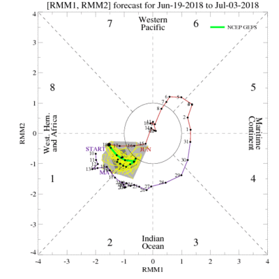
The Southwest Monsoon could not advance further since last one week due to weak monsoon flow in associations with (a) weak cross equatorial flow (ii) Unfavorable location of active phase of Madden Julian Oscillation (MJO) (iii) an equatorial eastwards propagating oscillations which lay over central & east Pacific Ocean, Western Hemisphere and Africa and (iv) development of low pressure system over northwest pacific Ocean.
However, the monsoon circulation is likely to improve from around 24th June with (i) expected movement of active phase of Madden Julian Oscillation (MJO) to west Equatorial Indian Ocean and adjoining Arabian Sea during next 2-3 days and (ii) development of cyclonic circulations over eastern India leading to strengthening of easterlies winds over Gangetic plains. As a result, the Southwest Monsoon is likely to further advance over remaining parts of Assam, some more parts of Maharashtra, Chhattisgarh, Odisha, West Bengal and some parts of Jharkhand, Bihar and Madhya Pradesh between 23rd to 25th June.
The Northern Limit of Monsoon continues to pass through Lat. 19°N/Long. 60°E, Lat. 19°N/Long. 70°E, Thane (including Mumbai), Ahmednagar, Buldhana, Amravati, Gondia, Titlagarh, Cuttack, Midnapore, Lat. 24°N/Long. 89°E, Goalpara, Baghdogra and Lat. 27°N/Long. 87°E.
CPC – NCEP GEFS MJO Forecast
IMD Advance Of Southwest Monsoon Map (click ‘Latest Advance for Latest Map)
Advance till 20-06-2018
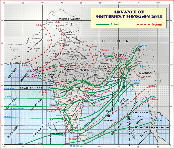
Latest Advance Map

Advance till 20-06-2018
Latest Advance Map
સૌથી ઉપર ની લીલી લીટી ના છેડે જે તારીખ હોઈ તે તારીખે લીટી ની નીચે ના ભાગ માં બધે ચોમાસું પોંચી ગયું છે તેમ સમજવું.
લાલ ત્રુટક લીટી જે તે વિસ્તાર માં નોર્મલ ચોમાસું બેસવાની તારીખ દર્શાવે છે
The date shown at the end of green line shows that the Southwest Monsoon has set in over areas below the green line on that date.
The red dashed line shows the normal date of onset of Southwest Monsoon over various regions
હાલ ની પરિસ્થિતિ અને નિચોડ:
ઓફશોર ટ્રફ કોંકણ થી કેરળ સુધી સી લેવલ ઉપર છે.
એક યુએસી દક્ષિણ કોંકણ/ગોવા આસપાસ છે જે 4.5 કિમિ ની ઊંચાઈ સુધી ફેલાયેલ છે.
એક યુએસી 0.75 કિમિ ની ઊંચાઈ સુધી બિહાર આસપાસ છે.
બિહાર થી એક ટ્રફ 1.5 ની ઊંચાઈ સુધી છે જે કોંકણ/ગોવા વાળા યુએસી સુધી લંબાય છે (વાયા છત્તીસગઢ ), જેમાં બિહાર વાળું યુએસી પણ બૂડ છે.
એક યુએસી હરિયાણા આસપાસ છે જે 1.5 કિમિ ની ઉંચાઇ સુધીછે.
સૌરાષ્ટ્ર, ગુજરાત અને કચ્છ: તારીખ 20 જૂન થી 27 જૂન 2018
પવન દક્ષિણ પશ્ચિમ ના છે. પવન થોડો ઓછો થયો છે આગળ દિવસો કરતા પવન ફરી 22 સુધી વધુ રહેશે.તારીખ 23 થી 27માં પવન ફરી ઓછો રહેશે. મહત્તમ તાપમાન હાલ છે તેનાથી તારીખ 23 થી ઘટશે। વાદળો 22 થી થશે અને આગાહી સમય માં રહેશે.
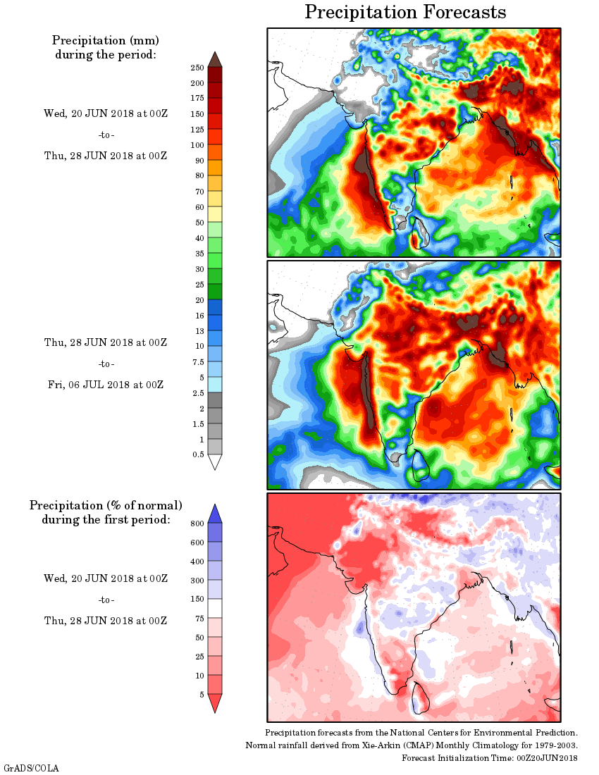
દક્ષિણ ગુજરાત, મધ્ય ગુજરાત, સૌરાષ્ટ્ર અને કચ્છ માં છુટા છવાયા ઝાપટા /હળવો વરસાદ મુખ્યત્વે આગાહી ના પાછળ ગાળા માં. દક્ષિણ ગુજરાત માં મધ્યમ વરસાદ સુધી ની શક્યતા પાછળ દિવસો માં અને 27 જૂન સુધી માં ચોમાસુ દક્ષિણ ગુજરાત માં એન્ટર થવાની શક્યતા છે. બીજા વિસ્તારો માં નોંધપાત્ર વરસાદ ની શક્યતા ઓછી. ભેજ 3.1 કિમિ માં ઓછો છે જે ગુજરાત બાજુ પહેલા વધશે અને ત્યાર બાદ સૌરાષ્ટ્ર બાજુ વધશે.
દક્ષિણ પશ્ચિમ ચોમાસુ તારીખ 23 થી 26 દરમિયાન બાકી ના આસામ , મહારાષ્ટ્ર ના ભાગો , છતીશગઢ ઓડિશા પશ્ચિમ બંગાળ માં આગળ વધશે તેમજ ઝારખંડ, બિહાર અને એમપી ના ભાગો માં દાખલ થઇ આગળ ચાલશે. અરબી પાંખ એક બે દિવસ મોડી ચાલશે અને 27 સુધી માં દક્ષિણ ગુજરાત માં દાખલ થશે.
Current Situation and Conclusions:
The is an Off-shore Monsoon trough at sea level now runs along Konkan to Kerala Coast.
The UAC over Madhya Maharashtra now lies over South Konkan/Goa and extends up to 4.5 km above mean sea level.
There is a UAC over Bihar and neighboring East U.P. at 0.75 km above mean sea level.
A trough runs from Bihar to the UAC along South Konkan/Goa at 1.5 km above mean sea level across Chhatishgarh, with the UAC over Bihar embedded in this trough.
There is a UAC over Haryana and extends up to 1.5 km above mean sea level.
Saurashtra, Gujarat & Kutch: 20th to 27th June 2018
Winds are mainly blowing from Southwest. The wind speed has reduced compared to earlier few days. Southwest winds will increase again till 22nd June and winds will be lower speed from 23rd to 27th June compared to earlier period. The Maximum Temperature will decrease from 22nd June and will be much lower from 23rd to 27th June compared to earlier period.
Scattered showers/light rain expected over South Gujarat, Central Gujarat, Saurashtra & Kutch mainly during later parts of forecast period. South Gujarat expected to receive higher quantum of medium rain during the latter parts of forecast period as Southwest Monsoon expected to enter South Gujarat by 27th June. Widespread meaningful rainfall possibility for other areas is limited during this period. Low level humidity is high, however the higher level (3.1 km above mean sea level) air is dry. The 3.1 km Humidity will increase during the latter parts of forecast period more towards Gujarat side compared to Saurashtra.
Overall Monsoon Situation:
Southwest Monsoon expected to Advance over remaining parts of Assam, some more parts of Maharashtra, Chhattisgarh, Odisha, West Bengal and enter over parts of Jharkhand, Bihar and Madhya Pradesh between 23rd to 26th June. The Arabian branch expected to move between 24th to 27th June.
Caution: Please refer/rely on IMD/RSMC Bulletins/Advisories for Storms & Weather related matter.
સાવચેતી:
સ્ટોર્મ કે હવામાન અંગે ની માહિતી માટે ભારતીય હવામાન ખાતા/ગવર્મેન્ટ ના બુલેટીન/સુચના પર નિર્ભર રહેવું.
Rajkot kothariyaroad varsad
Email address khotu chhe.
Havey sachu lakhvu email address
Sir 25 vali updet halni aagahi karta pogitev se?
Ee khabar hoy toe aaje aapel hoy ne !
Dakshin Saurashtra maate lakhel chhe aaje
Chotila ma dhimi dhare varsad chalu se
Sir rajkot ma dhodhmar varsad chalu
Vistar lakho…. Rajkot motu City chhe
at 5:00 pm
babra to jasdan vacche
rajula mahuva vache
ane chotila par
live thunderstorm batave che
friends varsad na vavad ni comments karta rehjo..tadhak thay
Sir hve arbi pankh continue chalu rehse k pachu break padse means valsad thi aagad vadhse hve??
Toonki Update aapi chhe
amari baju jordar adar se atyare
Jasdan ma dhimi dhare varsad ,,
4.40 pm
abhar sir
Mara gamni purva disama Jordar varsad salu. At Krankach Di Amreli.
Gariyadhar ma bars ad chalu
Dhasagam ma jordar pavan sathe varsad sharu
Ta.savarkundla…..gam.shantinagr vavni layak varsad se amare aaje…..2.45 pm thi saru…3.30 sudhi.
Sir Krachi delhi rajsthan na low presser thi faydo thase
Aakha chomasa darmiyan North West India ma Low hoy.
Ser porbandarma kyare varsad avse batavo
ગુડ આફટરનુન સર. ઉમરગામ થી સુરત તેમજ ભાવનગર અમરેલી મા વરસાદ ના અહેવાલ છે. હાલ આ વિસ્તારો મા કોઈ સિસ્ટમ તો નથી. 700 hpa મા હાફ રાઉન્ડ જેવુ દેખાય છે ઉમરગામ થી સુરત બાજુ તેમજ Windy મા ભાવનગર થી અમરેલી વચ્ચે આવુ દેખાય છે તો વરસાદ સેને આભારી છે?
East West shear zone 20N par chhe ane UAC 700 hPA ma Maharashtra
Sir aaje daksin saurastra ma varsad aavashe?
Hi Ashok Bhai,
Ahmedabad Weather Update :-
Gai kale east ma zapta ane west ma vij chamkara thaya…East na vaddo east ma ane west na vaddo west ma chalya gaya 🙁 fari rate 9ek vagye east south east mathi vaddo aavya but a bhi vikherai gaya 🙁
Fari aaje ghana vaddo che to fari aasha che k kaik thay 🙂
Thank you.
Sihor aas pass. 2. 30 વાગ્યે saru japtu padyu.
Sir Imd app ma kya click kar vat hi news aave ane gujrati plz.ans.
English aavde toe bhegu thay.
IMD App mey vapari nathi.
IMD website vaparu chhu. imd.gov.in
Imd na news sema jani sakay plz.ans.
IMD.gov.in
Positive change in atmosphere in junagadh today, considerable cloudiness although not that humid.
Sir su chomasu thoda Divsho Ma aakha saurashat ane Gujarat ma Beshi jase ?
Dakshin Gunarat ma besi gayu.
Imd monsoon progress image shows 23rd june monsoon line passen through Bulsar …..But iMD not writing anything in their report
They are re-updating their report.
સર આજે ચોમાસુ અાગળ વધુ અેવુ લાગે સે
Yes
Sir,
Add this link also.
http://satellite.imd.gov.in/dynamic/satbltn.pdf
I will try to incorporate it if possible
Sir have south saurastra ma megho kyare mandase khas karine junagadh baju?
IMD declared in today’s afternoon update that monsoon reached to South Gujarat at valsad.
Yes that is correct the MAP is Updated NML is now upto 20 North Latitude.
સર આજે ભાવનગર અને અમરેલી વારો કાઢસે
આ ચોમાસા દરમ્યાન અલનીનો ની અસર જણાય એવુ લાગે છે
NO
Direct Update 25th June 2018
SIdhi update avashe 25 tarikh aney Somvar 2018
Surat dhodhmar varsad…. Bo saro padi thyo che
Surat ma savar 9=30 am thinking dhodhmar varsad welcome monsoon
સૂરત મા જોરદાર વરસાદ