Current Weather Conditions on 29th October 2014 @ 8.30 pm.
For Latest Bulletin from REGIONAL SPECIALISED METEOROLOGICAL CENTRE-TROPICAL CYCLONES, NEW DELHI click here…
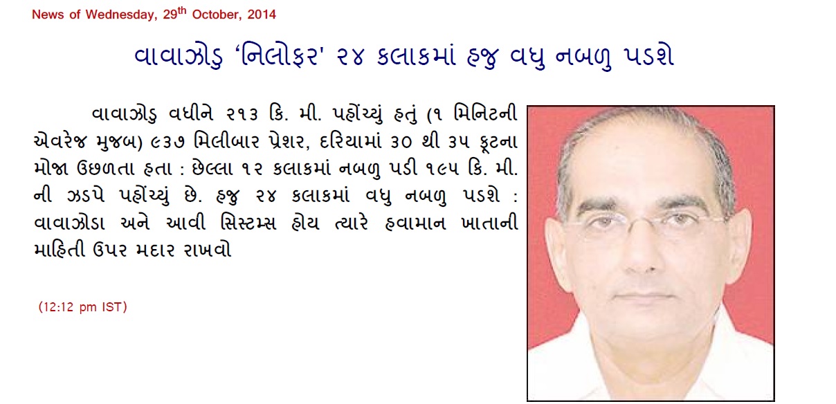
Very Severe Cyclonic Storm ‘NILOFAR’ over West Central Arabian Sea has weakened considerably from its peak of 115 knots (213 kms./hour on 1 minute average speed basis) yesterday to 90 knots (165 kms./hour on 1 minute average basis)
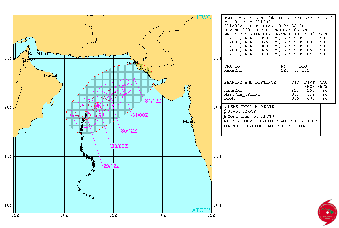
Current location at 1200 UTC on 29th October 2014 is Lat. 19.2 N & Long. 62.2 E with 90 knots winds (165 kms./hour on 1 minute average speed basis) and 956 mb. Central Pressure. The System has weakened by 25 knots from its peak. Wave height of 30 feet.
JTWC Tropical Cyclone Warning No. 17 Dated 29th October 2014 @ 1500 UTC
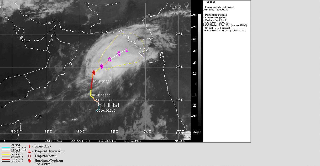
UW-CIMSS IR Satellite Image of VSCS ‘NILOFAR’
Dated 29th October 2014 @ 1330 UTC
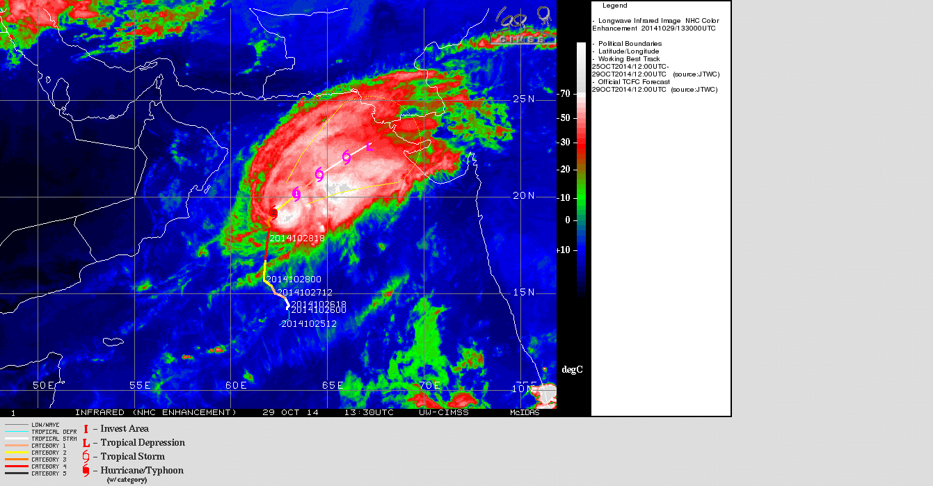
UW-CIMSS Color Enhenced IR Satellite Image of VSCS ‘NILOFAR’
Dated 29th October 2014 @ 1330 UTC
Forecast: 29th October to 2nd November 2014
Both major forecast models GFS & ECMWF have differing outcome for this System.
As per GFS the System will start weakening from now on wards and is expected to weaken considerably by 31st as it reaches vicinity of Saurashtra & Kutch & Sindh and remain there for two days.
As per ECMWF the System will start weakening from now on wards and dissipate at sea between 1st/2nd November far from Indian coast. This model does not expect the System to make landfall.
One thing is certain as per all models that the System is expected to weaken considerably during the next two days. However, there is less confidence in the final outcome about landfall as of now so update will be given as and when more clarity available.
Caution: Please refer/rely on IMD/RSMC Bulletins/Advisories for Storms & Weather related matter.
આગાહી તારીખ ૨૯ ઓક્ટોબર થી ૨ નવેમ્બર ૨૦૧૪:
મધ્ય પશ્ચિમ અરબી સમુદ્ર માં ‘નીલોફર’ નામનું અતિ તીવ્ર વાવાઝોડું હવે નબળું પડવાનું ચાલુ થયેલ છે. વધી ને ૧૧૫ નોટ ના પવનો ફૂંકતા હતા (૨૧૩ કિમી પ્રતિ કલાક ની ઝડપ ના પવનો જે ૧ મિનીટ ની એવરેજ મૂજબ ) અને ૯૩૭ મિલીબાર પ્રેસર હતું. ત્યાર બાદ ૨૪ કલાક માં નબળું પડી તારીખ ૨૯ ઓક્ટોબર ૨૦૧૪ ભારતીય સમય મૂજબ સાંજે ૫.૩૦ કલાકે ૯૦ નોટ ના પવનો છે (૧૬૫ કિમી પ્રતિ કલાક ના ૧ મિનીટ ની એવરેજ મૂજબ ) હતા.વાવાઝોડા આસપાસ દરિયા ના મોજા ૩૦ ફૂટ ઊંચા ઊછળતા હતા.
સીસ્ટમ નબળી પડવાનું ચાલુ રાખશે અને ત્યાર બાદ એક બે દિવસ વધુ નબળી પડી જશે.
એટલું નક્કી છે કે આ સીસ્ટમ નબળી થવાનું ચાલુ રહેશે પરંતુ આ સીસ્ટમની ચાલ અંગે હજુ ચોક્સાય કરવી પડે તેમ હોઈ જરૂર પ્રમાણે અપડેટ કરવામાં આવશે.
સૌરાષ્ટ્ર ગુજરાત અને કચ્છ માં સાવચેતી રાખવી કારણ કે પવન થી અને વરસાદ થી નૂકસાન થવાની શક્યતા થઇ શકે.
વાવાઝોડાના પવન બાબત ની સમજ :
ઊત્તર ગોળાર્ધ્ધ માં વાવાઝોડું હોઈ તેને અનૂસંગિક પવનો વાવાઝોડાના સેન્ટર થી એન્ટીકલોક(ઘડિયાળ ના કાંટા થી વિરૂદ્ધ )દિશામાં ફૂંકતા હોઈ છે.
વાવાઝોડાના પવનો ની ઝડપ ની જયારે વાત થતી હોઈ તે તેટલી સ્પીડે ફૂંકતા હોઈ છે.
વાવાઝોડું પોતે તો બહુ ધીમી સ્પીડે આગળ ચાલતું હોઈ છે. સામાન્ય રીતે ૫ થી ૧૫ કિમી પ્રતિ કલાકે આગળ ચાલતું હોઈ છે.
હવામાન ખાતા મૂજબ પવન ની ઝડપ નોટ તેમજ કિ.મી. પ્રતિ કલાક પ્રમાણે હોઈ છે જે ૩ મિનીટ ની શરેરાશ પવન ની ઝડપ મૂજબ હોઈ છે.
ઇન્ટરનેશનલ હવામાન એજન્સીઓ મૂજબ પવન ની ઝડપ નોટ તેમજ માઇલ પ્રતિ કલાક પ્રમાણે હોઈ છે જે ૧ મિનીટ ની શરેરાશ પવન ની ઝડપ મૂજબ હોઈ છે.
૧ નોટ =૧.૮૫૨ કી.મી.
૧ નોટ =૧.૧૫ માઇલ
એટલે ઇન્ટરનેશનલ હવામાન એજન્સીઓ તરફ થી પવન ની ઝડપ ભારતીય હવામાન ખાતા કરતા સામાન્ય રીતે ૧૦ % થી ૧૫ %વધુ હોઈ છે.
આ આગાહી http://www.gujaratweather.com – અશોક પટેલ ની છે.
નોંધ: વાવાઝોડા અને આવી સીસ્ટમ માટે હવામાન ખાતા ની માહિતી ઉપર મદાર રાખવો.
Weather Forecast In Akila Daily Dated 29th October 2014
00votes
Article Rating
17 Add your comment here
Inline Feedbacks
View all comments
Vijay Shihora
30/10/2014 1:38 pm
“NILOFAR” ni asar salaya ma kevi thase
Niraj Patel
30/10/2014 8:22 am
Sir central gujarat ma kevi asar rehse?
Paresh Patel
30/10/2014 7:45 am
Sar Botad ma kevo varsad pad che?
Kapupara ashvin
30/10/2014 5:54 am
Sir saurasht ma kayre ane kevo varasad padse plaese answer
ashok vala
29/10/2014 11:46 pm
junagdh ane pura vistar na jilao ma nai ave avu maru anuman 6
pradip
29/10/2014 10:56 pm
Sir rajkot ma atiyare vadlo avi gaya che
ashok vala
29/10/2014 10:34 pm
sahb nilofare. news ane havaman vada ye to keduto na bhura hal karya ho bhichara goda vari khursi ma bhethela vip o mate maha mahenate pak tyar karyo ane tene grahn lagu. toy haji dharti putra himat nathi haryo ho keshod ma kyay tadpatri madti nathi and amuk jagya ye che tya vepari am ke ke pela ame kaka ko pachi kye aj size aj bhav joi. to lyo nakar gidi karo ma. ane bija number ma akho divs ane ratre pan opner hakya hoi mela hadtha lugda hoi. oh oh ito tatj javadyo haveto nilofar avijay to NAI LAIYE… Read more »
Ramesh Karangia MBA
29/10/2014 10:29 pm
Sir samudra ma cyclone hoi tyare samudra varasad kevok hoi che
Kapupara ashvin
29/10/2014 10:13 pm
Sir saurasht ma havey rain padse ke madhym
manish pandya
29/10/2014 9:48 pm
Bhuj ma nilophar ni kevi ashar hase
Jagdish Sojitra
29/10/2014 9:40 pm
Kalavad taluka ma kevok varsad padshe?
jigar saraswat
29/10/2014 9:31 pm
Hello sir,
. Kutch to chodo aato ekdum u turn mare che I think its moving towards saurastra Jamnagar Porbandar may be not cyclon but heavy rain? Clouds coming towards us As per imd
“NILOFAR” ni asar salaya ma kevi thase
Sir central gujarat ma kevi asar rehse?
Sar Botad ma kevo varsad pad che?
Sir saurasht ma kayre ane kevo varasad padse plaese answer
junagdh ane pura vistar na jilao ma nai ave avu maru anuman 6
Sir rajkot ma atiyare vadlo avi gaya che
sahb nilofare. news ane havaman vada ye to keduto na bhura hal karya ho bhichara goda vari khursi ma bhethela vip o mate maha mahenate pak tyar karyo ane tene grahn lagu. toy haji dharti putra himat nathi haryo ho keshod ma kyay tadpatri madti nathi and amuk jagya ye che tya vepari am ke ke pela ame kaka ko pachi kye aj size aj bhav joi. to lyo nakar gidi karo ma. ane bija number ma akho divs ane ratre pan opner hakya hoi mela hadtha lugda hoi. oh oh ito tatj javadyo haveto nilofar avijay to NAI LAIYE… Read more »
Sir samudra ma cyclone hoi tyare samudra varasad kevok hoi che
Sir saurasht ma havey rain padse ke madhym
Bhuj ma nilophar ni kevi ashar hase
Kalavad taluka ma kevok varsad padshe?
Hello sir,
. Kutch to chodo aato ekdum u turn mare che I think its moving towards saurastra Jamnagar Porbandar may be not cyclon but heavy rain? Clouds coming towards us As per imd
Sir nilofar nablu padvanu su karan che
sir. amreli na khambha talukama kevo varsad pad 6e sir fast replay
સર રહસ્ય છેક સુધી અકબંધ રહ્યુ નિલોફર નુ.એન્ડ મા દરીયા મા જ સમાય જાશે નિલોફર.કુદરત પણ ખરી પરીક્ષા લે છે માણસ ની.
Keshod baju kevi asar rahase
Mangrol (jnd) baju kevi asar thase?