Current Weather Conditions on 7th September 2014 @ 11.00 pm.
The rainfall activity has stopped or become minimal over Saurashtra, Gujarat & Kutch from 5th/6th September.
The Well Marked Low Pressure over Chhatishgarh has now crossed over to Visarbha & vicinity. Associated Upper Air Cyclonic Circulation extends up to 7.6 Kms. above sea level tilting South Westwards with height.
The monsoon trough at mean sea level passes through Phalodi, Kota, Guna, Narsinghpur, Center of Well Marked Low Pressure area over Vidarbha & vicinity, Gopalpur, thence South Eastwards to East Central Bay of Bengal. It extends up to 3.1 Kms. above mean sea level.
A weak Off-shore trough at mean sea level runs from Gujarat coast to Lakshawdeep area.
Last Western Disturbance has moved away from Jammu & Kashmir. However, another Western Disturbance as an Upper Air Trough in Mid level Westerlies along longitude 65.0°E and latitude north of 25.0°N has come up.
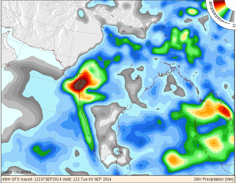
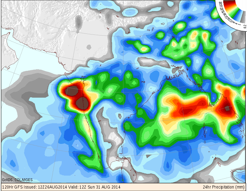
COLA/IGES GFS Precipitation Forecast Map Valid 1200 UTC 9th September 2014
COLA/IGES GFS Precipitation Forecast Map Valid 1200 UTC 10th September 2014
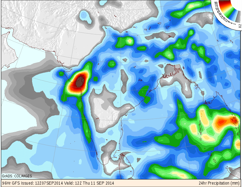
COLA/IGES GFS Precipitation Forecast Map Valid 1200 UTC 11th September 2014
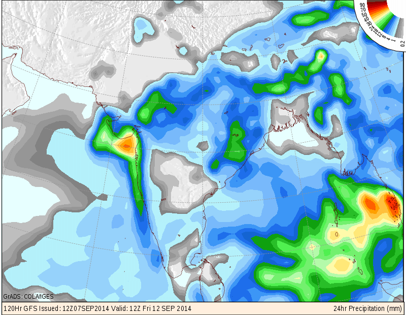
COLA/IGES GFS Precipitation Forecast Map Valid 1200 UTC 12th September 2014
COLA/IGES GFS Precipitation Forecast Map Valid 1200 UTC 8th September 2014
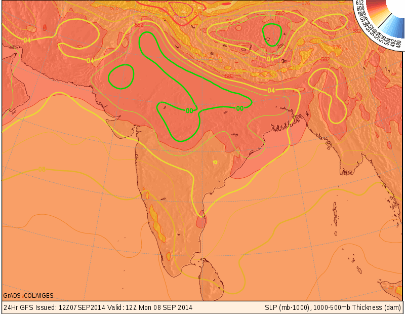
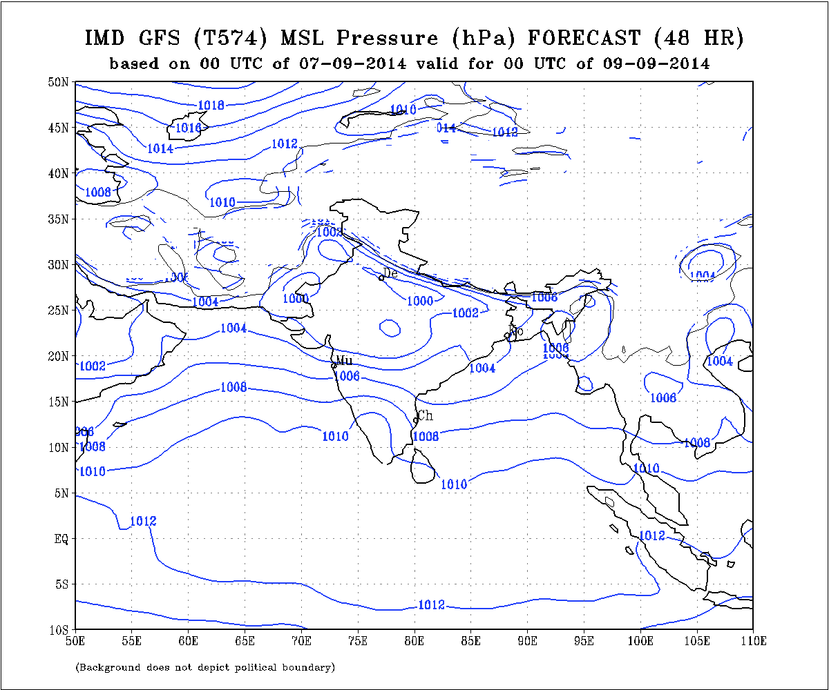
IMD MSL Pressure Forecast Map Valid for 0000 UTC 9th September 2014
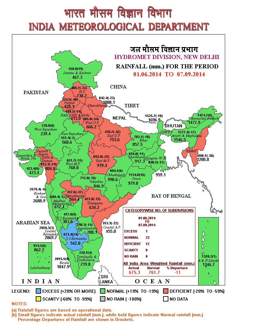
IMD All India Rainfall from 1st June to 7th September 2014
The above map shows that rainfall till 7th September is 11 % less than normal for the season till date. A very good recovery has taken place during the month of September.
Forecast: 8th September to 12th September 2014
Saurashtra, Gujarat & Kutch :
The Well Marked Low Pressure System will track West Northwestwards and will cross over to Madhya pradesh & vicinity. This System is not expected to come over Saurashtra or Gujarat. However, the associated UAC at 700 hPa is strong and would cover areas of Madhya Pradesh & Gujarat & Suarashtra. Also the clouding associated with this System is expected to be spread mainly on the West & Southwest of the System and would benefit both Gujarat & Saurashtra.
Major portions of South Gujarat, Central Gujarat & Coastal Saurashtra expected to get medium to very heavy rainfall during the forecast period.
50% of Interior Saurashtra is expected to get medium to heavy rainfall while other 50% of Interior Saurashtra is expected get light to medium rainfall during the forecast period.
North Gujarat is expected to get light to heavy rainfall during the forecast period.
Kutch could get light rain in the latter part of forecast period.
NOTE: On Vacation so post will be put if time permits !
સૌરાષ્ટ્ર, ગુજરાત અને કચ્છ :
તારીખ ૮ સપ્ટેમ્બર થી ૧૨ સપ્ટેમ્બર ૨૦૧૪:
બંગાળની ખાડી નું વેલ માર્કડ લો પ્રેસર મુખ્યતે પશ્ચિમ તરફ ગતિ કરી છાતીશ્ગઢ ઉપર થી હાલ વિદર્ભ ઉપર આવેલ છે. આ સીસ્ટમ હવે એમ. પી. બાજુ ૨૪ કલાક માં પોન્ચશે. ત્યાં થી ગુજરાત અને સૌરાષ્ટ્ર બાજુ આવવાની શક્યતા નથી પરંતુ તેને અનૂસંગિક એક ૭૦૦ hPa ઉપર UAC છે તે એમ. પી. ગુજરાત અને સૌરાષ્ટ્ર ઉપર ફેલાશે. તેવીજ રીતે આ સીસ્ટમ ના અનૂસંગિક વાદળ સમૂહો સીસ્ટમ થી પશ્ચિમે તેમજ દક્ષીણ પશ્ચિમે રહેશે. જેથી સૌરાષ્ટ્ર અને ગુજરાત ને ફાયદો થશે.
દક્ષીણ ગુજરાત તેમજ મધ્ય ગુજરાત ના મોટા ભાગ માં મધ્યમ થી અતિ ભારે વરસાદ ની શક્યતા છે. તેવીજ રીતે સૌરાષ્ટ્ર ના કાંઠા ના વિસ્તાર માં પણ મધ્યમ થી અતિ ભારે વરસાદ ની શક્યતા છે.
બાકી ના સૌરાષ્ટ્ર ના ૫૦% વિસ્તાર માં માધ્યમ ભારે વરસાદ ની શક્યતા અને બીજા ૫૦% વિસ્તાર માં હળવા થી મધ્યમ વરસાદ ની શક્યતા.
ઊતર ગુજરાત માં મધ્યમ વરસાદ ની શક્યતા છે.
કચ્છ માં હળવો વરસાદ આગાહી ના પાછલા દિવસો માં શક્યતા છે.
નોંધ: રજા માં બહાર ગામ હોવા થી નવી અપડેટ માટે વેલા મોડું ગણવું તેમજ પોસ્ટ ના જવાબ પણ વેલા મોડા મળશે.
ઉપર વરસાદ માટે નકશા આપેલ છે તેમાં ૪ દિવસ માં ક્યાં ક્યાં વરસાદ ની શક્યતા છે તે જોવું. થોડી મેનત કરી ને શીખો.
00votes
Article Rating
243 Add your comment here
Inline Feedbacks
View all comments
ragesh patel
11/09/2014 7:52 pm
sir,
new update kyare ap so , pl replay.
vijay lagariya
11/09/2014 2:50 pm
heavy rian aje bhanvad na gaamdaoma sir
dharmendra thumar
11/09/2014 12:26 pm
Upleta ma savar Na 9 vagya thi varasad chalu chhe
jiva ata
11/09/2014 10:40 am
good news%kesodma aje saro varsad avse
Ashok sojitra
10/09/2014 8:19 pm
sir…. rajkot ma aa round ma varsad aavese ke nahi
bansipatel
10/09/2014 8:11 pm
Sir USC VIKHAY GAU KESU GONDAL MA VARSAD AAVOJ NAY AAVANARA DIVASO MA AAVA6 PLZ
Hiten patel
10/09/2014 7:44 pm
Sir here in surendranagar that is heavy rain in last 2 days.
So what will possibility in next few days.
I m a farmer son so it is really matter for me.
Sir please reply
Hiten patel
10/09/2014 7:36 pm
Sir surendeanagar ma Kevo varsad rahse.
Have avanaro badho varsad ahi mate nuksan karak j chhe.badha pak ma pani Chad Gaya chhe.
Sir please reply

sir,
new update kyare ap so , pl replay.
heavy rian aje bhanvad na gaamdaoma sir
Upleta ma savar Na 9 vagya thi varasad chalu chhe
good news%kesodma aje saro varsad avse
sir…. rajkot ma aa round ma varsad aavese ke nahi
Sir USC VIKHAY GAU KESU GONDAL MA VARSAD AAVOJ NAY AAVANARA DIVASO MA AAVA6 PLZ
Sir here in surendranagar that is heavy rain in last 2 days.
So what will possibility in next few days.
I m a farmer son so it is really matter for me.
Sir please reply
Sir surendeanagar ma Kevo varsad rahse.
Have avanaro badho varsad ahi mate nuksan karak j chhe.badha pak ma pani Chad Gaya chhe.
Sir please reply
sir aavanara divaso ma varsad nu praman kevu rahse.
Heavy rain aje himatnagar area ma 7.30 to 1.00 pm darmyan 5 to 5.5 inch varsad thayo….