Current Weather Conditions on 5th September 2014 @ 11.00 pm.
Very good round of rainfall has now ended over Saurashtra, Kutch & Gujarat.
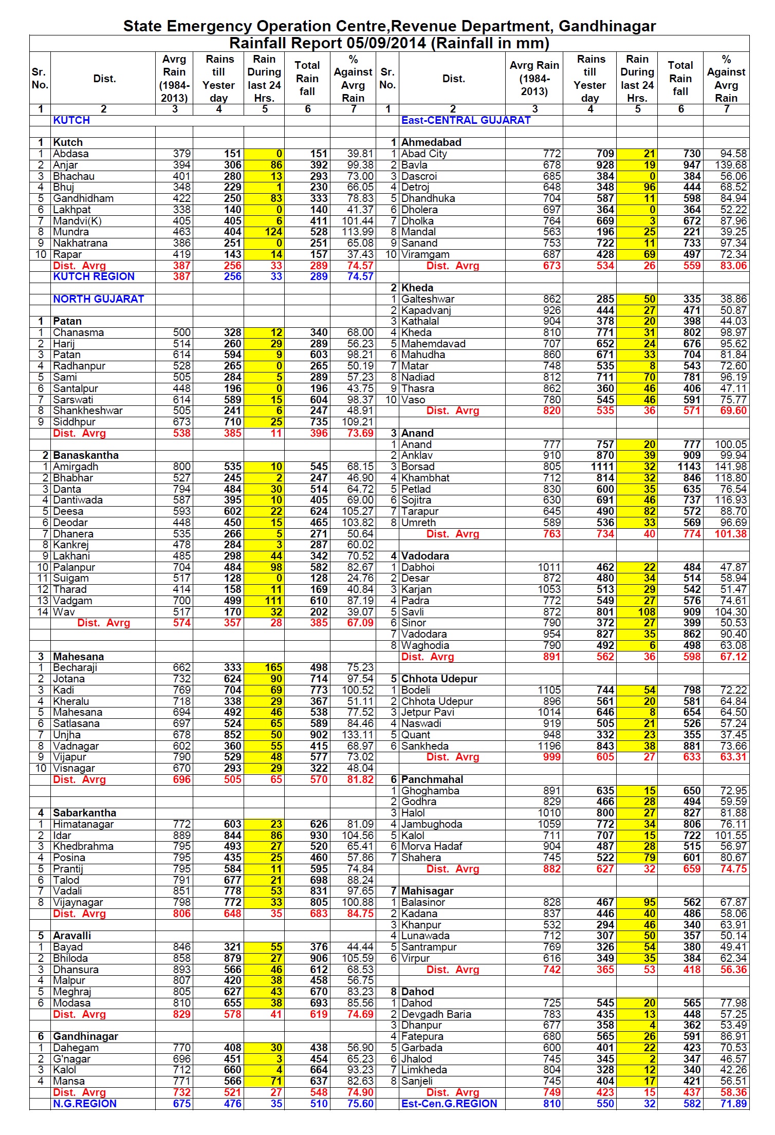
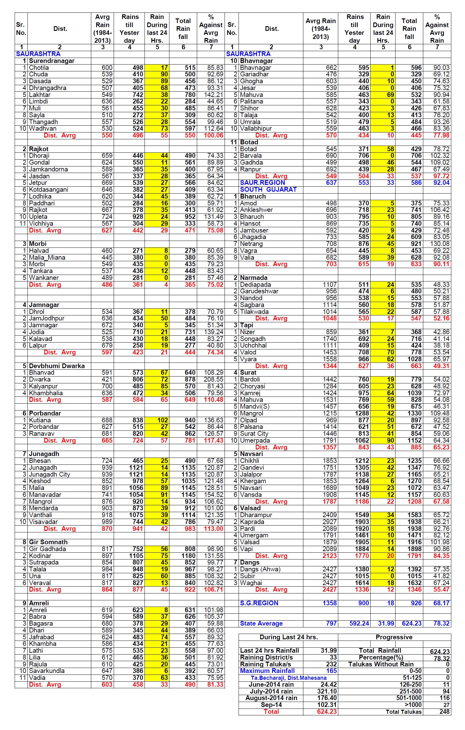
Rainfall status as on 5th September 2014 @ 8.30 am. over whole Gujarat is given here under:
An Upper Air Cyclonic Circulation over northwest Bay of Bengal and neighborhood had developed on 4th September. Under the influence of this UAC, a Low Pressure area has formed over North Bay of Bengal off west Bengal – Bangla Desh coasts.
Associated cyclonic circulation extends up to Mid Tropospheric levels tilting Southwestwards with height.
IMD MSL Pressure Forecast Map Valid for 0000 UTC 5th September 2014
A Well Marked Low Pressure area now lies over Northwest Rajasthan and adjoining areas of Haryana and Punjab. Associated Cyclonic Circulation extends up to Mid Tropospheric levels.
The axis of monsoon trough at mean sea level passes through the Center of Well Marked Low Pressure area over Northwest Rajasthan, Sikar, Gwalior, Satna, Jamshedpur, Center of Low Pressure area over North Bay of Bengal and thence Southeastwards to East Central Bay of Bengal. Axis extends up to 3.1 Kms. above sea level.
The Off-shore trough at mean sea level is active from South Gujarat coast to Kerala coast persists.
The Western Disturbance as a trough in Mid and Upper Tropospheric Westerlies with its axis at 5.8 Kms. above sea level runs along 74° E to the North of 28° N. System would move East Northeastwards.
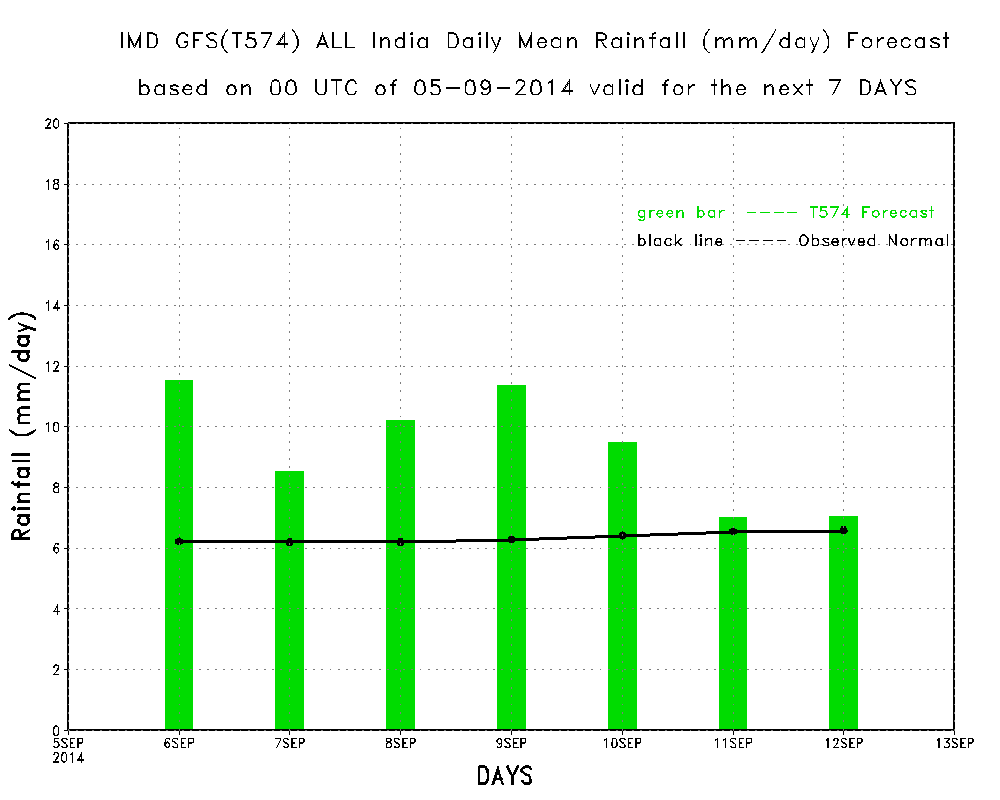
IMD Daily All India Mean Rainfall (mm./day) Forecast Till 12th September 2014
The above weekly forecast graph shows that the rainfall for the week ending 12th September is expected to be above normal for India.
Forecast: 6th September 11th September 2014
The Low Pressure over North Bay of Bengal will remain in that area for a day and then track initially Westwards towards Odisha, Chhatishgarh & Vidarbha around 8th September. Subsequent track of this System will have to be monitored because there is difference between the GFS & ECMWF forecast track. Looking to both these models we can say that the System would reach Madhya Pradesh. Further track would be updated as and when clarity occurs.
Saurashtra, Gujarat & Kutch :
Last rainfall round is over.
Now major parts of Saurashtra, Kutch & North Gujarat will get scattered showers over isolated pockets from 6th to 8th September on a day or two.
East & South Coastal areas of Saurashtra is expected to get medium to heavy rainfall 9th/11th September, while rest of Saurashtra could get scattered showers or light rain on 9th/11th September.
Starting from 8th/9th September till 11th September South Gujarat and Central Gujarat bordering Madhya Pradesh is expected to get medium to heavy rainfall.
Update will be given if there is change in forecast track of the System.
સૌરાષ્ટ્ર, ગુજરાત અને કચ્છ :
તારીખ ૬ સપ્ટેમ્બર થી ૧૧ સપ્ટેમ્બર ૨૦૧૪:
ઊત્તર બંગાળની ખાડી માં એક નવું લો પ્રેસર થયું છે. તેને અનૂસંગિક અપાર એર સાયક્લોનિક સરક્યું લેસન લો ની દક્ષીણ પશ્ચિમે છવાયેલ છે. આ સીસ્ટમ એક દિવસ તે વિસ્તાર માં રહેશે અને ત્યાર બાદ મુખ્યત્વે પશ્ચિમ તરફ ગતિ કરશે. ઓડીશા તેમજ છતીશગઢ ઉપર થઇ ને વિદર્ભ સુધી ૮ તારીખ આસપાસ પોન્ચશે. અને ત્યાર બાદ તારીખ ૯ આસપાસ એમ.પી. ઉપર આવશે. આ સીસ્ટમ એમ.પી. થી આગળ ગુજરાત બાજુ ચાલશે કે નહિ તેનું નક્કી નથી. વરસાદ ની માત્રા પણ તેના પર નિર્ભર હોઈ એટલે બે દિવસ પછી અપડેટ આપવામાં આવશે.
તારીખ ૬ થી ૮ દરમ્યાન સૌરાષ્ટ્ર કચ્છ અને ઊત્તર ગુજરાત ના મોટા ભાગો માં વરસાદ નું પ્રમાણ નહીવત રહેશે.
તારીખ ૯ થી ૧૧ દરમ્યાન સૌરાષ્ટ્ર ના કાંઠા ના ભાગો ખાસ કરી ને પૂર્વ તેમજ દક્ષીણ કાંઠા ના ભાગો માં મધ્યમ ભારે વરસાદ ની શક્યતા છે. બાકી ના સૌરાષ્ટ્ર માં છૂટા છવાયા ઝાપટા અહવા હળવો વરસાદ ની શક્યતા છે.
તારીખ ૮ થી ૧૧ સુધી દક્ષીણ ગુજરાત તેમજ એમ. પી. ને લાગુ મધ્ય ગુજરાત માં મધ્યમ ભારે વરસાદ ની શક્યતા છે.
ઊત્તર ગુજરાત અને કચ્છ માટે તારીખ ૬ થી ૮ દરમ્યાન વરસાદ નો વિરામ રહેશે. ત્યાર બાદ તારીખ ૯ થી ૧૧ માટે બે દિવસ પછી અપડેટ આપવામાં આવશે.
નોંધ: રજા માં બહાર ગામ હોવા થી નવી અપડેટ માટે વેલા મોડું ગણવું તેમજ પોસ્ટ ના જવાબ પણ વેલા મોડા મળશે.
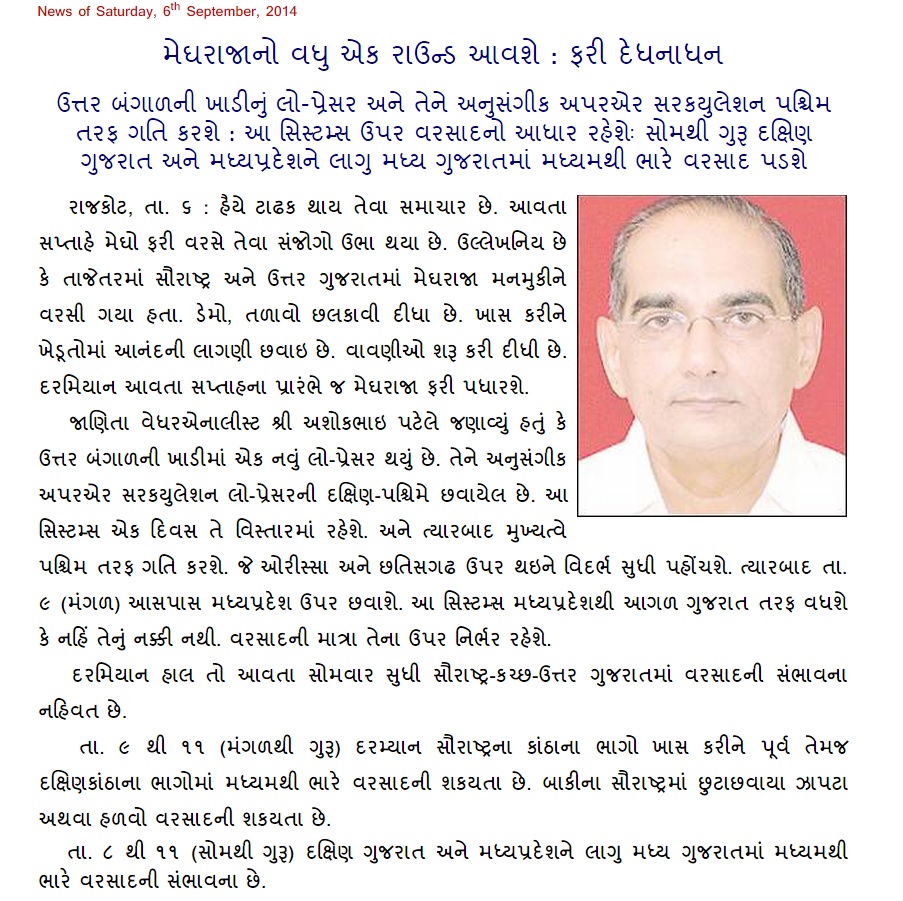
Weather Forecast In Akila Daily Dated 6th September 2014
સુધારો: “વાવણીઓ શરુ કરી દીધી છે” તે ભૂલ થી છપાયેલ છે.
Yes sir, I know you can’t predict from one image but I am just asking because I have noticed that the system is moving towards Gujarat so I just asked you.
Raj
07/09/2014 7:37 pm
Sir you were going to give the update tonight (indian time), we are waiting for it. What will be forecast for Ahmedabad and surrounding during the period. Please reply.
sir when cloud imaginary we saw that round is shown in bottem side and area of cloud is less than well mark low and is concentrated in upper and middle side.


Sir ketli vaar Che update mate?
Update mukay gai che. gujarati kalak pachhi avashe.
sir on accuweather.com it is showing that the system is radiply moving towards gujarat and will bring heavy rain. what do you say.
We are waiting next update.today 11 pm
sir tame india pahosi gaya so ? pravas kevo rahio sir?
Na, Hu U.S. ma chhu.
Sir,2013 ni jem aa year ma ek sathe 20 inch varasad ni sambhavana chhe ke nai
Sir on IMD the current infra-red image of 6.30 PM IST shows that the system is coming towards Gujarat. What is your forecast. Please reply.
Evu chokkas na kahi shakay. Ek time na image mathi kem khabar pade?
Yes sir, I know you can’t predict from one image but I am just asking because I have noticed that the system is moving towards Gujarat so I just asked you.
Sir you were going to give the update tonight (indian time), we are waiting for it. What will be forecast for Ahmedabad and surrounding during the period. Please reply.
Yes 11.00 pm. tonight
sir india saru ke US?
sir when cloud imaginary we saw that round is shown in bottem side and area of cloud is less than well mark low and is concentrated in upper and middle side.
It is not possible to say about Depression without the MSLP charts.