30th May 2020
Upper Air Cyclonic Circulation Over Southeast Arabian Sea – Expected To Become A Low Pressure By 1st June Helping Monsoon Progress
દક્ષિણ પૂર્વ અરબી સમુદ્ર પર અપર એર સાયક્લોનિક સર્ક્યુલેશન – 1 જૂન સુધી માં લો પ્રેસર થવાની શક્યતા જે ચોમાસા ને આગળ ચાલવા માં મદદ કરશે
Current Weather Conditions:
The Depression over South coastal Oman and adjoining Yemen remained practically stationary during past 06 hours and lay centered at 0830 hrs IST of today, the 30th May, 2020 near latitude 17.3°N and longitude 54.2°E, about 30 km north-northeast of Salalah (Oman) and 240 km east-northeast of Al Ghaydah (Yemen). It is very likely to intensify further into a deep depression during next 12 hours. It is very likely to move slowly west-northwestwards during next 12 hours and west-southwestwards thereafter. No adverse weather is expected over Indian region due to this system, since it is located far away from Indian coast.
The Northern Limit of Monsoon (NLM) continues to pass through Lat.7°N/Long.50°E, Lat.7°N/Long.60°E, at.7°N/Long.70°E, Lat.6°N/Long.75°E, Lat.6°N/Long.79°E, Lat.8°N/Long.86°E, Lat.11°N/Long.90°E, Lat.14°N/Long.93°E and Lat.16°N/Long.95°E.
Conditions are becoming favorable for further advance of Southwest Monsoon into some more parts of South Arabian Sea, Maldives-Comorin area, Southwest and Southeast Bay of Bengal during next 24 hours.
The Western Disturbance as an upper level trough now seen between 3.1 and 5.8 km above mean sea level roughly along longitude 68°E to the north of latitude 28°N.
There is an Upper Air Cyclonic Circulation up to 5.8 km above mean sea level over Southeast Arabian Sea off Kerala coast. JTWC has this UAC as 93A.INVEST location 9.9N, 72.4E.
Forecast: Up to 3rd June for Potential System.
A Low Pressure area is very likely to form over Southeast & adjoining Eastcentral Arabian Sea by 1st June and it is likely to strengthen as it tracks North Northwest along Indian Coast and reach East Central Arabian Sea, West of Maharashtra coast and South of Saurashtra Coast by 3rd June. There is a big difference in Forecast track of GFS and ECMWF and hence an update will be given on Monday the 1st June. Monsoon expected to set in over Kerala by 1st June 2020.
Click the link below. Page will open in new window
IMD MSLP Chart for 11.30 am. of 2nd June 2020
ઉપર ની લિન્ક ક્લિક કરો. નવી વિન્ડો માં પેજ ખૂલશે
Forecast: Saurashtra, Gujarat & Kutch for 30 May to 6th June 2020
Weather will be partly cloudy. It will be windy till 2nd June and subsequently winds will be less. However, winds will be affected by upcoming Low Pressure System. Pre-Monsoon activity with thunder will start from 1st to 6th June. Rain quantum will be updated on Monday 1st June 2020. Maximum Temperature will reduce and humidity will increase from 2nd June.
NRL IR Satellite Image of 93A.INVEST ( UAC/ Potential Low Pressure)
Dated 30-05-2020 @ 1000 UTC ( 03.30 pm. IST) 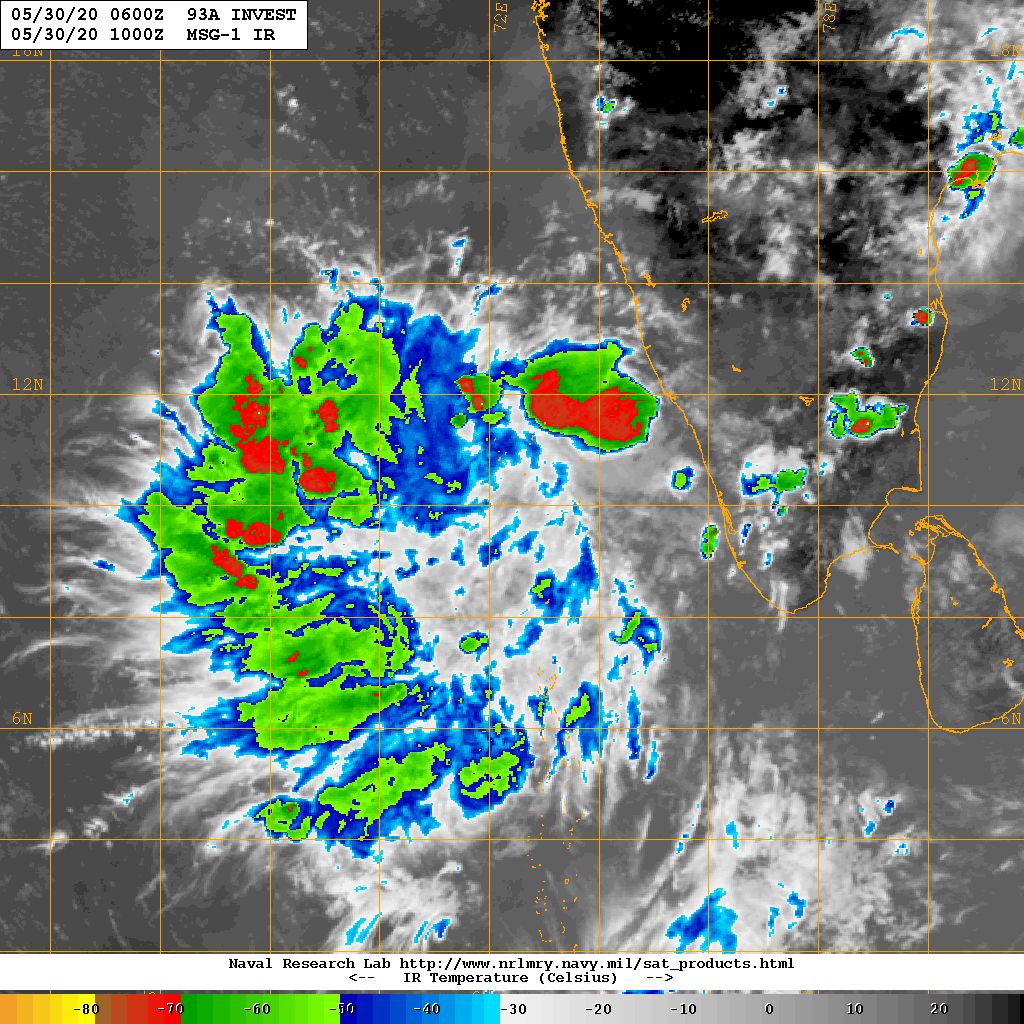
Caution: Please refer/rely on IMD/RSMC Bulletins/Advisories for Storms & Weather related matter.
સાવચેતી: સ્ટોર્મ કે હવામાન અંગે ની માહિતી માટે ભારતીય હવામાન ખાતા/ગવર્મેન્ટ ના બુલેટીન/સુચના પર નિર્ભર રહેવું.
Click the links below. Page will open in new window
Read Forecast In Akila Daily Dated 30th May 2020
Read Forecast In Sanj Samachar Daily Dated 30th May 2020
Read Comment Policy– કમેન્ટ માટે માર્ગદર્શન
ઉપર ની બધી અલગ લિન્ક ક્લિક કરો. નવી વિન્ડો માં પેજ ખૂલશે