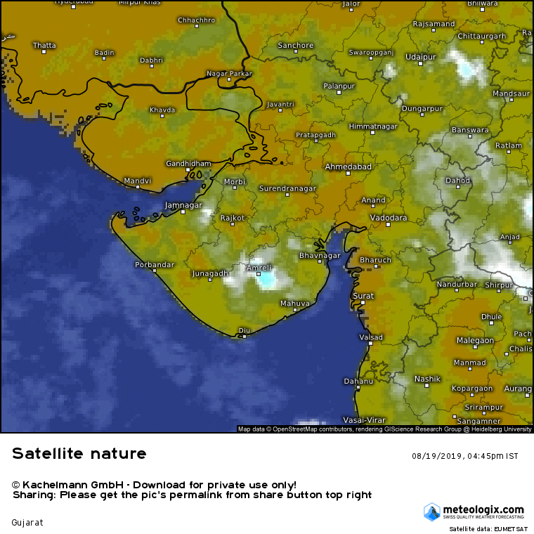
Current Conditions on 19th August 2019
Reduced Rainfall Activity Over Saurashtra Gujarat & Kutch For This Week
સૌરાષ્ટ્ર ગુજરાત અને કચ્છ માં આઅઠવાડિયું વરસાદી માહોલ ઓછો રહેશે
Map showing some Rainfall activity over Saurashtra
Afternoon/Evening of 19th August 2019
Some weather parameters from IMD:
The Low Pressure Area over Western parts of Gangetic West Bengal & adjoining Jharkhand now lies over North Jharkhand & adjoining Bihar with the associated Cyclonic Circulation extending up to 7.6 km above mean sea level.
The Monsoon Trough at mean sea level now passes through Firozpur, Kaithal, Meerut, Lucknow, Churk, center of Low Pressure Area over North Jharkhand & adjoining Bihar, Purulia, Digha and thence Southeastwards to Northwest Bay of Bengal.
The Cyclonic Circulation over Haryana & adjoining West Uttar Pradesh now lies over Northwest Uttar Pradesh & neighborhood between 1.5 km & 3.1 km above mean sea level.
The Cyclonic Circulation over Southwest Bay of Bengal off north Tamil Nadu coast now lies over North coastal Tamil Nadu & neighborhood between 3.1 km & 4.5 km above mean sea level.
An East West shear zone runs roughly along Latitude 14°N between 5.8 km & 7.6 km above mean sea level across South peninsula.
An off shore trough at mean sea level runs from Karnataka coast to North Kerala coast.
A Cyclonic Circulation between 2.1 & 4.5 km above mean sea level lies over Saurashtra & neighborhood.
The Western Disturbance as a trough in Mid & Upper Tropospheric Westerlies with its axis at 5.8 km above mean sea level persists roughly along Long 72°E to the North of Lat 30°N.
19 ઓગસ્ટ 2019 વાતાવરણ ની પરિસ્થિતિ:
નવું લો પ્રેસર હવે નોર્થ ઝારખંડ અને લાગુ બિહાર પર છે. તેના આનુસંગિક યુએસી 7.6 કિમિ ની ઉંચાઈ સુધી ફેલાયેલ છે.
ચોમાસુ ધરી હવે ફિરોઝપુર, કૈથલ, મિરત , લખનૌવ, નોર્થ ઝારખંડ વાળું નવું લો પ્રેસર, પુરુલિયા, દીઘા અને ત્યાંથી નોર્થ વેસ્ટ બંગાળ ની ખાડી સુધી લંબાય છે.
નોર્થ ઇન્ડિયા વાળું જૂનું લો પ્રેસર નબળું પડી હવે ફક્ત યુએસી તરીકે નોર્થવેસ્ટ યુપી એન્ડ લાગુ વિસ્તારો પર છે જે 1.5 કિમિ થી 3.1 કિમિ ની ઉંચાઈ માં છે.
અરબી સમુદ્રમાં 1.5 કિમિ થી 3.1 કિમિ માં ટ્રફ છે જેનો એક છેડો સૌરાષ્ટ્ર/કચ્છ પર છે. 1.5 થી 2.1 કિમિ માં ભેજ નું પ્રમાણ ઠીક છે પણ 3.1 કિમિ માં ભેજ ઓછો છે.
ઑફ શોર ટ્રફ સી લેવલ પર કર્ણાટક દરિયા કિનારાથી થી નોર્થ કેરળ કિનારા સુધી છે.
Saurashtra Gujarat & Kutch : Forecast Dated 19th to 25th August 2019
Rainfall activity will be less over most areas with Isolated showers/rain during the period. Conditions expected to improve for rain around 25th August.
સૌરાષ્ટ્ર ગુજરાત અને કચ્છ: આગાહી 19 ઓગસ્ટ થી 25 ઓગસ્ટ 2019
સૌરાષ્ટ્ર, ગુજરાત અને કચ્છ ના મોટા વિસ્તાર માં વાદળ તડકો મિક્ક્ષ વાતાવરણ રહેશે તેમજ વરસાદ ની માત્રા ઓછી રહેશે. આગાહી સમય માં છુટા છવાયા ઝાપટા/વરસાદ. તારીખ 25 ઓગસ્ટ આસપાસ વરસાદ માટે વાતાવરણ ફરી સુધરશે.