Current Weather Conditions on 13th August 2019
Some weather features from IMD :
The Low Pressure Area over Northwest Bay of Bengal and adjoining West Bengal & North Odisha coast now lies over Southern parts of Gangetic West Bengal & adjoining North Odisha and associated Cyclonic Circulation extends up to 7.6 km above mean sea level tilting Southwestward with height. It is likely to become more marked during next 48 hours.
The Monsoon Trough at mean sea level now passes through Firozpur, Patiala, Baghpat, Mainpuri, Sidhi , Daltonganj, Chaibasa, Centre of Low Pressure Area over Southern parts of Gangetic West Bengal & adjoining North Odisha and thence Southeastwards to Eastcentral Bay of Bengal.
The off-shore trough at mean sea level from South Gujarat coast to Lakshadweep area now runs from Maharashtra coast to North Kerala coast.
The Low Pressure area over Northwest Arabian Sea & neighborhood has become less marked. However the Associated Cyclonic Circulation persists over same area and now extends up to 4.5 km above mean sea level tilting Southwestward with height.
Saurashtra, Gujarat & Kutch: Current conditions
There is a surplus of 26% rain till 13th August 2019 for Saurashtra & Kutch Region, and Gujarat Region also has a surplus of 26% rain till 13th August 2019. Kutch has received lot of rain and so now has a surplus of 48% rain from normal till 13th August 2019.
Forecast: 13th August to 18th August 2019
Note: I do not Forecast more than a week ( Referred to as Hu LGAKN in the blog comments)
Mixed weather during the forecast period with more cloudy weather 14-16th August.
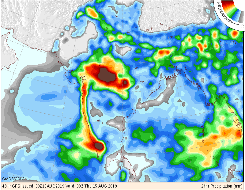
Monsoondata (COLA): 14th August Morning to 15th August Morning
Monsoondata (COLA): 15th August Morning to 16th August Morning
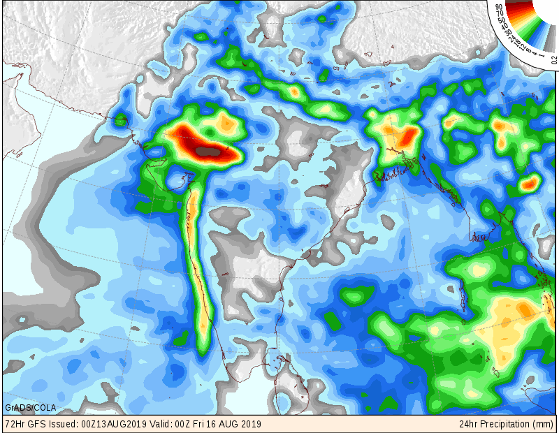
South Gujarat, East Central Gujarat and North Gujarat: 75% areas expected to receive 50 mm to 75 mm with some high rainfall centers reaching 100 mm rainfall during the forecast period & 25% areas expected to receive 25 mm to 50 mm rainfall during the forecast period mainly 14th to 16th August.
Saurashtra & Kutch: 50% areas expected to receive 20 mm to 40 mm with some high rainfall centers reaching 50 mm rainfall during the forecast period & 50% areas expected to receive scattered showers to 20 mm rainfall during the forecast period mainly 14th to 16th August.
સૌરાષ્ટ્ર, ગુજરાત અને કચ્છ: તારીખ 13 ઓગસ્ટ થી 18 ઓગસ્ટ 2019
13 ઓગસ્ટ 2019 ની સ્થિતિ:
નોર્થવેસ્ટ બંગાળ ની ખાડી માં ગઈ કાલે લો પ્રેસર થયું હતું તે આજે પશ્ચિમ બંગાળ ના પશ્ચિમ ભાગ માં અને લાગુ નોર્થ ઓડિશા પર હતું. તેના આનુસંગિક સાયક્લોનિક સર્ક્યુલેશન 7.6 કિમિ ની ઉંચાઈ સુધી ફેલાયેલ છે અને વધતી ઉંચાઈએ દક્ષિણ પશ્ચિમ તરફ ઝુકે છે. આ સિસ્ટમ આવતા 48 કલાક માં વેલ માર્કંડ થવાની શક્યતા છે.
જે છેલ્લી સિસ્ટમ ગુજરાત પર થી પાસ થઇ હતી તે હવે નોર્થવેસ્ટ અરબી સમુદ્ર માં છે અને નબળી પડી ગઈ છે. તેના આનુસંગિક યુએસી 4.5 કિમિ ની ઉંચાઈ સુધી ફેલાયેલ છે.
ચોમાસુ ધરી હાલ ફિરોઝપુર, પટિયાલા, બાઘપત, મૈનપુરી, સીધી, દલોતગંજ, ચૈબાસા, લો પ્રેસર સેન્ટર, અને ત્યાંથી માધ્ય પૂર્વ બંગાળ ની ખાડી સુધી લંબાય છે.
હવે ઑફ શોર ટ્રફ હવે મહારાષ્ટ્ર ના કિનારા થી નોર્થ કેરળ ના કિનારા સુધી લંબાય છે.
સૌરાષ્ટ્ર કચ્છ વિસ્તાર માં 13 ઓગસ્ટ સુધી અત્યાર સુધી માં જે નોર્મલ થવો જોઈએ તેનાથી 26 % વધુ વરસાદ થયેલ છે. તેવીજ રીતે ગુજરાત રીજીયન (દક્ષિણ, મધ્ય અને નોર્થ ગુજરાત ) પણ 26% વધુ વરસાદ થયેલ છે.
આગાહી: 13 ઓગસ્ટ થી 18 ઓગસ્ટ 2019
નોંધ: હું એક અઠવાડિયા થી વધુ ની આગાહી કરતો નથી. Hu LGAKN એટલે હું લાંબા ગાળા ની આગાહી કરતો નથી !
આગાહી ના દિવસો માં 14-16 ઓગસ્ટ વાદળ છાયું વાતાવરણ. બાકી ના દિવસો મિક્સ વાતાવરણ.
દક્ષિણ ગુજરાત, મધ્ય પૂર્વ ગુજરાત અને નોર્થ ગુજરાત: 75 % વિસ્તાર માં આગાહી સમય માં કુલ 50 મિમિ થી 75 મિમિ વરસાદ ની શક્યતા અને વધુ વરસાદ વાળા સેન્ટર માં 100 મિમિ સુધી જે મુખ્યત્વે 14-15-16 ના & બાકી ના 25% વિસ્તાર માં કુલ 25 મિમિ થી 50 મિમિ વરસાદ ની શક્યતા.
સૌરાષ્ટ્ર અને કચ્છ: 50 % વિસ્તાર માં આગાહી સમય માં કુલ 20 મિમિ થી 40 મિમિ વરસાદ ની શક્યતા અને વધુ વરસાદ વાળા સેન્ટર માં 50 મિમિ સુધી જે મુખ્યત્વે 14-15-16 ના & બાકી ના 50% વિસ્તાર માં છુટા છવાયા ઝાપટા થી લઇ ને કુલ 20 મિમિ વરસાદ ની શક્યતા.
Caution: Please refer/rely on IMD/RSMC Bulletins/Advisories for Storms & Weather related matter.
સાવચેતી:
સ્ટોર્મ કે હવામાન અંગે ની માહિતી માટે ભારતીય હવામાન ખાતા/ગવર્મેન્ટ ના બુલેટીન/સુચના પર નિર્ભર રહેવું.
Click the links below. Page will open in new window
Read Comment Policy – કમેન્ટ માટે માર્ગદર્શન વાંચો
How To Upload Profile Picture For WordPress – વર્ડપ્રેસ માં પ્રોફાઈલ પિક્ચર કેમ રાખવું
Read Forecast In Akila Daily Dated 13th August 2019
Read Forecast In Sanj Samachar Daily Dated 13th August 2019
ઉપર ની બધી અલગ લિન્ક ક્લિક કરો. નવી વિન્ડો માં પેજ ખૂલશે