Current Weather Conditions on 6th July 2019
Saurashtra & Kutch Has To Wait For Widespread Meaningful Rainfall – Southwest Monsoon Expected To Cover Whole India Within Two Days Except Parts Of West Rajasthan.
સૌરાષ્ટ્ર અને કચ્છ ને સાર્વત્રિક નોંધપાત્ર વરસાદ માટે હજુ રાહ જોવી પડશે – દક્ષિણ પશ્ચિમ ચોમાસુ આવતા બે દિવસ માં પશ્ચિમ રાજસ્થાન ના ભાગો શિવાય સમગ્ર દેશ માં બેસી જશે.
As per IMD :
Northern Limit of Monsoon (NLM) continues to pass through Lat. 25°N/Long. 60°E, Lat. 25°N/Long. 65°E, Barmer, Jodhpur, Sikar, Rohtak, Chandigarh, Una and Amritsar.
Conditions are becoming favorable for further advance of Southwest Monsoon into remaining parts of Haryana, Punjab and some more parts of Rajasthan during next 48 hours.
The Cyclonic Circulation over Southeast Uttar Pradesh and adjoining Northeast Madhya Pradesh now lies over South Uttar Pradesh & adjoining north Madhya Pradesh and extends up to 1.5 km above mean sea level.
The Cyclonic Circulation over Central Pakistan & adjoining West Rajasthan now lies over North Pakistan & adjoining Punjab and extends up to 1.5 km above mean sea level.
The trough at mean sea level from Northwest Rajasthan to Northeast Bay of Bengal persists and runs across Northeast Rajasthan, South Uttar Pradesh, Jharkhand & Gangetic West Bengal and extends up to 1.5 km above mean sea level. The other branch of it now runs from Jharkhand to Manipur across Bangladesh and Assam & Meghalaya.
The Cyclonic Circulation over south Gujarat Region & neighborhood persists and now seen between 3.1 and 3.6 km above mean sea level.
The Cyclonic Circulation over Northwest Bay of Bengal & adjoining Gangetic West Bengal now lies over West Bengal & adjoining Jharkhand and extends up to 7.6 km above mean sea level tilting Southwestwards with height.
IMD Advance Of Southwest Monsoon Map.
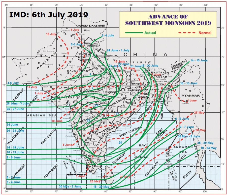
સૌથી ઉપર ની લીલી લીટી ના છેડે જે તારીખ હોઈ તે તારીખે લીટી ની નીચે ના ભાગ માં બધે ચોમાસું પોંચી ગયું છે તેમ સમજવું.
લાલ ત્રુટક લીટી જે તે વિસ્તાર માં નોર્મલ ચોમાસું બેસવાની તારીખ દર્શાવે છે
The date shown at the end of green line shows that the Southwest Monsoon has set in over areas below the green line on that date.
The red dashed line shows the normal date of onset of Southwest Monsoon over various regions
Saurashtra, Gujarat & Kutch: 6th July to 13th July 2019
Very windy and cloudy conditions expected throughout the Forecast period with winds reaching 25-35 km at some time during the day.
Forecast:
South Gujarat & East Central Gujarat could receive scattered Medium/Heavy Rainfall with Isolated very Heavy Rainfall till 7th July. The rain quantum as well as rainfall area will be less for rest of the forecast period.
Saurashtra, Kutch & Rest of Gujarat could receive scattered Showers/Light Rainfall on a few days of the forecast period with Isolated Heavy Rainfall. Saurashtra & Kutch has to yet wait for meaningful widespread Rainfall.
સૌરાષ્ટ્ર, ગુજરાત અને કચ્છ: તારીખ 6 જુલાઈ થી 13 જુલાઈ 2019
ચોમાસુ ઉત્તરી રેખા હાલ Lat. 25°N/Long. 60°E, Lat. 25°N/Long. 65°E, થી બારમેર, જોધપુર, શિકર, રોહતક, ચંદીગઢ, ઉના, અને અમૃતસર થી પાસ થાય છે. હજુ ચોમાસુ હરિયાણા પંજાબ ના બધા ભાગો તેમજ રાજસ્થાન ના થોડા વધુ ભાગો માં આગળ ચાલશે આવતા 2 દિવસ માં.
યુએસી 1.5 કિમિ ની ઊંચાઈ નું હાલ દક્ષિણ યુપી અને લાગુ નોર્થ એમપી પર છે.
સી લેવલ નું ટ્રફ નોર્થવેસ્ટ રાજસ્થાન થી નોર્થઇસ્ટ બંગાળ ની ખાડી તરફ જાય છે વાયા દક્ષિણ યુપી, ઝારખંડ, પશ્ચિમ બંગાળ અને તે 1.5 કિમિ ની ઊંચાઈએ છે. બીજી પાંખ ઝારખંડ થી મણિપુર જાય છે વાયા બાંગ્લા દેશ , આસામ , અને મેઘાલય.
3.1 કિમિ થી 3.6 કિમિ નું યુએસી દક્ષિણ ગુજરાત/દક્ષિણ સૌરાષ્ટ્ર અને લાગુ વિસ્તારો પર છે, જે હવે યુએસી નું ટ્રફ થશે.
નોર્થવેસ્ટ બંગાળ ની ખાડી બાજુ થી એક નવું યુએસી 7.6 કિમિ ના લેવલ સુધી ફેલાયેલ છે જે હવે પશ્ચિમ બંગાળ અને લાગુ ઝારખંડ પર છે.
આગાહી:
વાદળછાયું વાતાવરણ તેમજ દિવસ ના ક્યારેક પવન 25 થી 35 કિમિ ની ઝડપ સુધી ફૂંકાય આગાહી ના બધા દિવસો માં.
દક્ષિણ ગુજરાત અને મધ્ય પૂર્વ ગુજરાત માં છુટા છવાયો મધ્યમ/ભારે વરસાદ ની શક્યતા છે 7 તારીખ સુધી. ત્યાર બાદ વરસાદ ની માત્રા અને વિસ્તાર ઓછો રહેશે.
સૌરાષ્ટ્ર, કચ્છ અને નોર્થ ગુજરાત: છુટા છવાયા ઝાપટા /હળવો વરસાદ. સીમિત વિસ્તાર માં અમુક દિવસ મધ્યમ વરસાદ. સાર્વત્રિક નોંધપાત્ર વરસાદ માટે હજુ રાહ જોવી પડે.
Caution: Please refer/rely on IMD/RSMC Bulletins/Advisories for Storms & Weather related matter.
સાવચેતી:
સ્ટોર્મ કે હવામાન અંગે ની માહિતી માટે ભારતીય હવામાન ખાતા/ગવર્મેન્ટ ના બુલેટીન/સુચના પર નિર્ભર રહેવું.