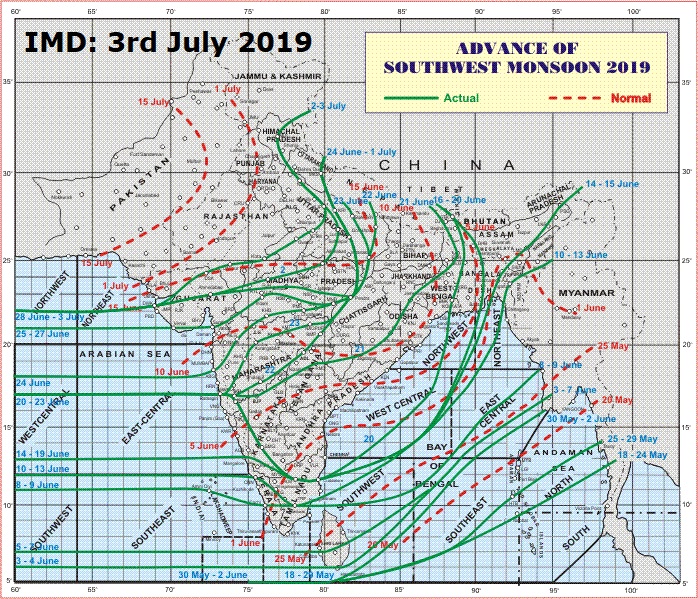
3rd July 2019 Update
Southwest monsoon has further advanced into some more parts of Gujarat, Rajasthan, Madhya Pradesh and Uttar Pradesh. Northern Limit of Monsoon (NLM) passes through Lat. 22°N/Long. 60°E, Lat. 22°N/Long. 65°E, Dwarka, Deesa, Udaipur, Kota, Gwalior, Shahjahanpur, Najibabad, Mandi and Lat. 33°N/Long. 79°E.
The Well Marked Low Pressure area over North Chhattisgarh and adjoining areas of Jharkhand & Odisha now lies over Northeast Madhya Pradesh & neighborhood and associated cyclonic circulation extends up to 7.6 km above mean sea level tilting Southwards with height.
In association with its likely westnorthwest ward movement, conditions are becoming favorable for further advance of Southwest Monsoon into remaining parts of North Arabian Sea, Gujarat, Madhya Pradesh, some more parts of Rajasthan, Himachal Pradesh, Jammu & Kashmir, remaining parts of Uttar Pradesh and Uttarakhand and some parts of Haryana, Chandigarh & Delhi during next 48 hours.
આજે ચોમાસુ ઉત્તર ગુજરાત માં ડીસા સુધી પહોંચી ગયું. નકશો જોવો.. વેલ માર્ક લો પ્રેસર હાલ નોર્થ ઇસ્ટ એમપી પર છે. ચોમાસુ હજુ 2 દિવસ માં અરબી સમુદ્ર, ગુજરાત ના બાકી ના ભાગો માં આગળ ચાલશે.
IMD Advance Of Southwest Monsoon Map
Current Weather Conditions on 1st July 2019
Well Marked Low Pressure Now Over Northwest Bay Of Bengal Near Coastal Odisha & West Bengal – Expected To Concentrate To A Depression by Tomorrow & Will Track Towards Madhya Pradesh.
વેલ માર્કંડ લો પ્રેસર નોર્થવેસ્ટ બંગાળ ની ખાડી અને લાગુ ઓડિશા/પશ્ચિમ બંગાળ ના કિનારા પર છે – 24 કલાક માં હજુ મજબૂત બની ડિપ્રેસન માં પરિવર્તિત થશે અને એમપી બાજુ ગતિ કરશે.
As per IMD :
Southwest monsoon has further advanced into some more parts of north Arabian Sea, Gujarat & Madhya Pradesh. Northern Limit of Monsoon (NLM) passes through Lat. 22°N/Long. 60°E, Lat. 22°N/Long. 65°E, Dwarka, Ahmedabad, Bhopal, Jabalpur, Pendra, Sultanpur, Lakhimpur Kheri, Mukteshwar and Lat. 31°N/Long. 80°E.
The Low Pressure Area over northwest Bay of Bengal & adjoining areas of north Odisha, West Bengal and Bangladesh coasts now lies as a Well Marked Low Pressure area over Northwest Bay of Bengal & adjoining areas of West Bengal and Odisha coasts. Associated cyclonic circulation extends up to 7.6 km above mean sea level tilting Southwestwards with height. It is likely to concentrate into a Depression during next 24 hours.
In association with this, conditions are very likely to become favorable for further advance of Southwest Monsoon into remaining parts of North Arabian Sea, Gujarat, Madhya Pradesh, Chhattisgarh, some parts of Rajasthan & Himachal Pradesh, some more parts of Uttar Pradesh and remaining parts of Uttarakhand during next 72 hours.
Due to likely westward movement of Low Pressure System, widespread rainfall with Heavy to Very Heavy falls at a few places &
Extremely heavy falls at isolated places very likely over Odisha on 01st July, Chhattisgarh, Vidarbha on 01st & 02nd July, East Madhya Pradesh on 2nd & 3rd July and over Telengana on 01st July, 2019. Konkan & Goa, Madhya Maharashtra, Marathwada, Gujarat region, East Rajasthan and West Madhya Pradesh are very likely to witness enhanced rainfall activity from 3rd July on wards.
IMD Advance Of Southwest Monsoon Map
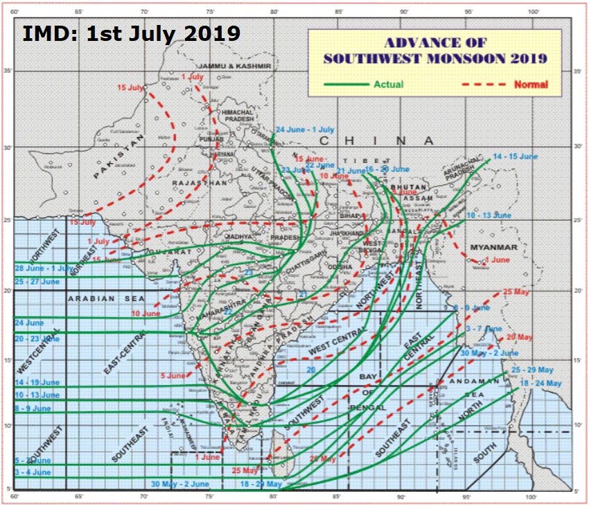
સૌથી ઉપર ની લીલી લીટી ના છેડે જે તારીખ હોઈ તે તારીખે લીટી ની નીચે ના ભાગ માં બધે ચોમાસું પોંચી ગયું છે તેમ સમજવું.
લાલ ત્રુટક લીટી જે તે વિસ્તાર માં નોર્મલ ચોમાસું બેસવાની તારીખ દર્શાવે છે
The date shown at the end of green line shows that the Southwest Monsoon has set in over areas below the green line on that date.
The red dashed line shows the normal date of onset of Southwest Monsoon over various regions
Saurashtra, Gujarat & Kutch: 1st July to 6th July 2019
The trough at mean sea level now runs from northwest Rajasthan to Center of the Well Marked Low Pressure Area over Northwest Bay of Bengal across North M.P. & Adjoining U.P., and Gangetic West Bengal and extends up to 0.9 km above mean sea level.
The Cyclonic Circulation over South Gujarat & neighborhood persists & now lies between 2.1 & 3.6 km above mean sea level.
An East-West Shear Zone runs roughly along Lat. 20°N between 4.5 & 5.8 km above mean sea level.
The Western Disturbance as a Cyclonic Circulation over North Pakistan & neighborhood persists and now seen at 3.1 km above mean sea level.
Forecast:
Due to cumulative effects of the UAC over South Gujarat, the East West Shear Zone & the UAC associated with the BOB System tracking towards M.P., more benefit to Gujarat Region compared to Saurashtra & Kutch Region.
South Gujarat & East Central Gujarat could receive Medium/Heavy Rainfall with Isolated very Heavy Rainfall on few days of the forecast period.
Saurashtra, Kutch & Rest of Gujarat could receive scattered Light/Medium Rainfall on a few days of the forecast period with Isolated Heavy Rainfall.
Note: Forecast based on majority models except German Model. The only Model which is very positive for both Gujarat & Saurashtra is the German Model.
સૌરાષ્ટ્ર, ગુજરાત અને કચ્છ: તારીખ 1 જુલાઈ થી 6 જુલાઈ 2019
હાલ ટ્રફ 0.9 કિમિ ના લેવલ માં નોર્થ વેસ્ટ રાજસ્થાન થી WMLP સેન્ટર સુધી લંબાય છે વાયા નોર્થ એમપી અને લાગુ યુપી અને પશ્ચિમ બંગાળ.
દક્ષિણ ગુજરાત અને લાગુ વિસ્તારો પર એક યુએસી છે 2.1કિમિ અને 3.6 કિમિ ના લેવલ માં.
એક ઇસ્ટ વેસ્ટ શિયર ઝોન 20N Lat. પર છે, જે અરબીયન સમુદ્ર, દક્ષીણ ગુજરાત પર થી WMLP સુધી લંબાય છે. જે 4.5 અને 5.8 કિમિ લેવલ માં છે.
એક વેસ્ટર્ન ડિસ્ટર્બન્સ નોર્થ પાકિસ્તાન અને લાગુ વિસ્તારો પર 3.1 કિમિ ના લેવલ પર યુએસી તરીકે છે.
હવામાન ખાતા મુજબ: બંગાળ ની ખાડી ની સિસ્ટમ તેમજ બીજા પરિબળો સુધારતા હોય દક્ષિણ પશ્ચિમ ચોમાસુ આવતા 72 કલાક માં સમગ્ર નોર્થ અરબી સમુદ્ર, ગુજરાત, એમ પી, છતીશગઢ , રાજસ્થાન અને હિમાચલ પ્રદેશ ના થોડા ભાગો, યુપી ના થોડા વધુ ભાગો અને ઉત્તરાખંડ ના બાકી ના ભાગી માં બેસી જશે.
આગાહી:
દક્ષિણ ગુજરાત ના યુએસી, ઇસ્ટ વેસ્ટ શિયર ઝોન તેમજ બંગાળની ખાડી ની સિસ્ટમ આનુસંગિક યુએસી કે તેનો ભાગ ની સંયુક્ત અસર થી ગુજરાત રિજીયન માં સૌરાષ્ટ્ર કચ્છ રીજીયન કરતા વધુ ફાયદો થશે.
દક્ષિણ ગુજરાત અને મધ્ય પૂર્વ ગુજરાત માં મધ્યમ/ભારે અને ક્યાંક ક્યાંક અતિ ભારે વરસાદ ની શક્યતા છે, આગાહી સમય ના અમુક દિવસો.
સૌરાષ્ટ્ર, કચ્છ અને નોર્થ ગુજરાત: છુટા છવાયો હળવો/મધ્યમ વરસાદ તો ક્યાંક ક્યાંક મધ્યમ/ભારે વરસાદ ની શક્તા આગાહી ના અમુક દિવસો.
નોંધ: આગાહી જર્મન મોડલ સિવાય ના ઘણા મોડલ પર આધારિત છે. જર્મન મોડલ પ્રમાણે ચાલે તો સૌરાષ્ટ્ર નો બેડો પાર થઇ જાય.
Caution: Please refer/rely on IMD/RSMC Bulletins/Advisories for Storms & Weather related matter.
સાવચેતી:
સ્ટોર્મ કે હવામાન અંગે ની માહિતી માટે ભારતીય હવામાન ખાતા/ગવર્મેન્ટ ના બુલેટીન/સુચના પર નિર્ભર રહેવું.