Update on 28th August 2018
Daily Rainfall figures are here
Gujarat Dam Rainfall figures are here
Gujarat Dam storage details are here
Meteorological features partly based on IMD Mid-Day Bulletin:
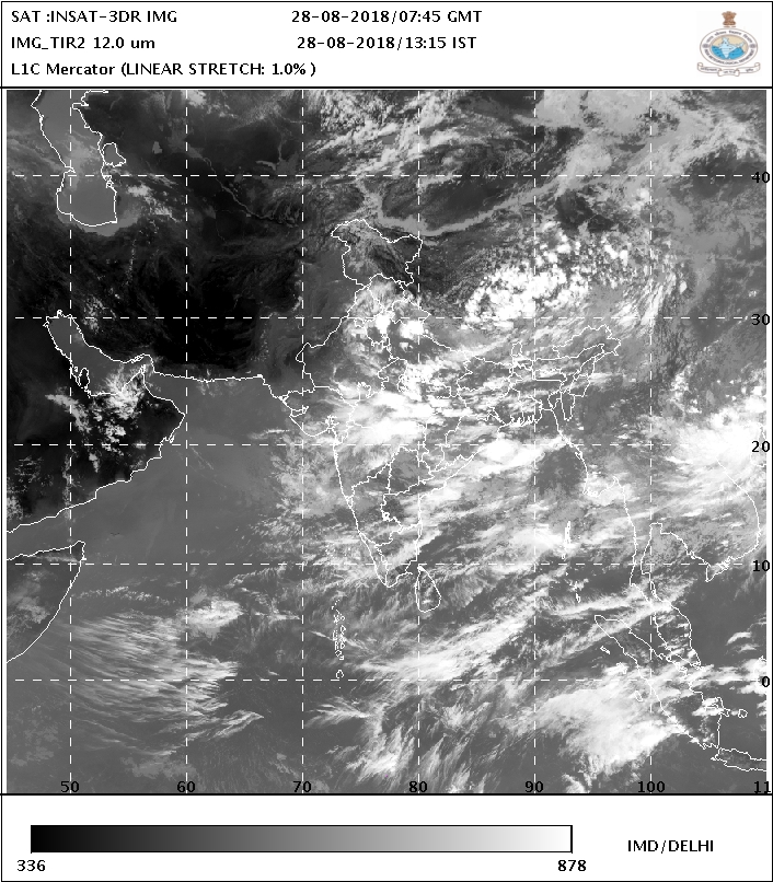
Low Pressure from BOB is now less marked over North Odisha/North Chatishgarh and its Associated Cyclonic Circulation extends up to 4.5 km above mean sea level tilting Southwestwards with height.
The Axis of Monsoon trough at mean sea level now passes through Bhatinda, Hissar, Alwar, Gwalior, Satna, Ambikapur, Jamshedpur, Digha, and thence towards northeast Bay of Bengal.
There is a UAC over South Haryana & neighborhood and extends up to 3.1 Km above mean sea level.
The Cyclonic Circulation over Saurashtra/Gujarat and neighborhood at 3.1 Km to 4.5 km above mean sea level.
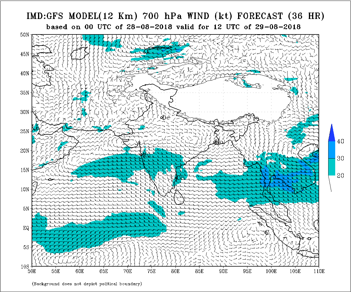
East West shear zone is forming near/over Saurashtra/Gujarat to Madhya Pradesh at 3.1 km to 4.5 km above mean sea level.
A Western Disturbance as a trough in Mid-level Westerlies with its axis at 5.8 km above mean sea level runs roughly along long. 72.0° E and to the north of 32.0° N.
Saurashtra, Gujarat & Kutch: 28th to 31st August 2018
Due to the UAC over Saurashtra & neighborhood, and formation of an East west Shear zone at 3.1 to 4.5 km near/over Saurashtra to Madhya Pradesh, rainfall is expected over many parts of Gujarat region and some parts over Saurashtra & Kutch. The rainfall coverage will depend upon the Latitude location of the East West shear zone. The rainfall will start from the border areas of Eastern side of Gujarat and later the rainfall area will move Westwards.
Gujarat expected to receive 25 mm to 75 mm rainfall during the forecast period. Some locations will receive less amount depending upon the location of East West shear zone.
Saurashtra expected to receive scattered showers/light/medium rain during the forecast period.
Kutch expected to receive scattered showers/light rain and isolated medium rain during the forecast period,
Caution: Please refer/rely on IMD/RSMC Bulletins/Advisories for Storms & Weather related matter.
હાલ ની પરિસ્થિતિ અને નિચોડ: 28 ઓગસ્ટ 2018
બંગાળ ની ખાડી નું લો પ્રેસર હવે નબળું પડ્યું અને તેનું અપર એર સાયક્લોનિક સર્ક્યુલેશન છે જે નોર્થ ઓડિશા/ નોર્થ છતીશગઢ આસપાસસ છે અને 4.5 કિમિ ની ઊંચાઈ સુધી ફેલાયેલ છે.
ચોમાસુ ધરી ભટિંડા, હિસાર,અલવર,ગ્વાલિયર, સતના, અંબિકાપુર , જમશેદપુર, અને ત્યાંથી નોર્થઇસ્ટ બંગાળ ની ખાડી તરફ લંબાય છે.
એક યુએસી દક્ષિણ હરિયાણા અને આસપાસ 3.1 કિમિ ના લેવલ માં છે.
સૌરાષ્ટ્ર/ગુજરાત આસપાસ એક યુએસી 3.1 થી 4.5 કિમિ ના લેવલ માં છે.
એક ઇસ્ટ વેસ્ટ શિયર ઝોન બનવામાં છે સૌરાષ્ટ્ર/ગુજરાત આસપાસ/પર થી એમપી સુધી 3.1 થી 4.5 કિમિ ના લેવલ માં.
વરસાદ ના આંકડા, ડેમ ઉપર વરસાદ ના આંકડા તેમજ ડેમ સ્ટોરેજ ની વિગત ઉપર લિંક માં આપેલ છે.
સૌરાષ્ટ્ર, ગુજરાત અને કચ્છ: તારીખ 28 ઓગસ્ટ થી 31 ઓગસ્ટ 2018
સૌરાષ્ટ્ર /ગુજરાત નજીક/ઉપર એક ઇસ્ટ વેસ્ટ શિયર ઝોન એમપી સુધી લંબાશે ને તેને હિસાબે ગુજરાત ના ઘણા ભાગો માં વરસાદ ની શક્યતા છે. સૌરાષ્ટ્ર અને કચ્છ માં વરસાદ વિસ્તાર અને માત્રા ની અનિશ્ચિતતા રહેશે જે શિયાર ઝોન લોકેશન પર નિર્ભર રહેશે. વરસાદ પહેલા ગુજરાત ના પૂર્વ બોર્ડર બાજુ થી ચાલુ થશે અને ત્યાર બાદ પશ્ચિમ બાજુ વરસાદ આગળ વધશે.
ગુજરાત : આગાહી સમય ના અમૂક દિવસો વિસ્તારો પ્રમાણે વરસાદ ની શક્યતા છે જેની કુલ વરસાદ ની માત્રા 25 મીલીમીટર થી 75 મીલીમીટર ની શંભાવના. ઇસ્ટ વેસ્ટ શિયર ઝોન લોકેશન પર અમૂક વિસ્તાર માં ઓછી માત્રા.
સૌરાષ્ટ્ર વિસ્તારમાં આગાહી સમય ના અમૂક દિવસો વિસ્તારો પ્રમાણે ઝાપટા/હળવો/મધ્યમ વરસાદ ની શંભાવના.
કચ્છ : આગાહી સમય ના અમૂક દિવસો વિસ્તારો પ્રમાણે ઝાપટા/હળવો ક્યાંક મધ્યમ વરસાદ ની શંભાવના.
સાવચેતી:
સ્ટોર્મ કે હવામાન અંગે ની માહિતી માટે ભારતીય હવામાન ખાતા/ગવર્મેન્ટ ના બુલેટીન/સુચના પર નિર્ભર રહેવું.