Update on 21st August 2018
Meteorological features partly based on IMD Morning Bulletin:
The Low Pressure Area from the Bay of Bengal now lies over Northeast Madhya Pradesh & neighborhood. The Associated Cyclonic Circulation extends at 3.1 km above mean sea level over Madhya Pradesh/Maharashtra while at 5.8 km above mean sea level is over Maharashtra & neighborhood.
The axis of monsoon trough at mean sea level now passes through Amritsar, Narnaul, Gwalior, centre of The Low Pressure Area over northeast Madhya Pradesh & neighbourhood, Jharsiguda, Chandbali and thence towards Eastcentral Bay of Bengal.
There is a Cyclonic Circulation over Northeast Arabian Sea Off Saurashtra Coast at 3.1 km above mean sea
level. Trough from this UAC extends Northeast towards Saurashtra & Southwest towards West Central Arabian Sea.
A broad Circulation from Madhya Pradesh to Gujarat and extending Southwest from Saurashtra over Arabian Sea is expected to form by tomorrow.

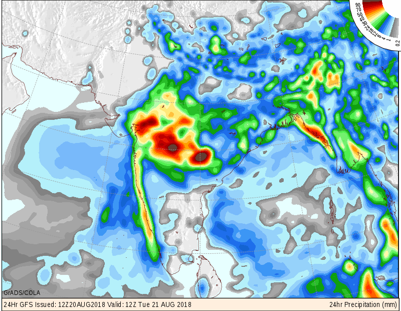
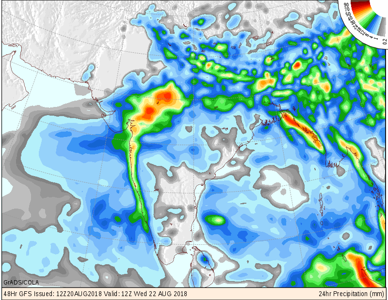
Saurashtra, Gujarat & Kutch: 21st-22nd August 2018
Central Gujarat, Northeast Gujarat & South Gujarat:
Failry widespread Medium to Heavy rain with very heavy rain at isolated places expected over these regions on 21st-22nd August 2018. See Precipitation maps.
Rest of Gujarat, Saurashtra & Kutch Areas :
60% areas expected to receive scattered showers/light/medium rainfall with isolated heavy rain on 21st and 22nd August 2018
40% areas expected to receive scattered showers/light rainfall on 21st and 22nd August 2018
COLA Precipitation Map – Color Table shows rainfall in mm for 24 hours.
COLA – જમણી બાજુ ખૂણા માં આપેલ વિવિધ કલર પ્રમાણે 24 કલાક નો અલગ અલગ વિસ્તાર માં મીલીમીટર માં વરસાદ સમજવો.
પરિસ્થિતિ અને નિચોડ: 21 ઓગસ્ટ 2018
બંગાળ ની ખાડી નું લો પ્રેસર પૂર્વ મધ્ય પ્રદેશ આસપાસ છે. તેના અનૂસંગિક સાયક્લોનિક સર્ક્યુલેશન 3.1 કિમિ માં મધ્ય પ્રદેશ/ મહારાષ્ટ્ર પર છે અને 5.8 કિમિ ના લેવલ માં મહારાષ્ટ્ર અને આસપાસ ના વિસ્તારો પર છે.
ચોમાસુ ધરો અમૃતસર, ગ્વાલિયર લો પ્રેસર સેન્ટર અને ત્યાંથી ચાંદબાલી અને મધ્ય પૂર્વ બંગાળ ની ખાડી તરફ લંબાય છે
એક યુએસી સૌરાષ્ટ્ર નજીક અરબીયન સમુદ્ર માં છે 3.1 કિમિ ના લેવલ માં. તેનો ટ્રફ સૌરાષ્ટ્ર તરફ છે અને બીજો છેડો દક્ષિણ પશ્ચિમ બાજુ માધ્ય અરબી સમુદ્ર બાજુ છે.
ઉપરોક્ત બંને સર્ક્યુલેશન નું એક બહોળું સર્ક્યુલેશન 3.1 મધ્ય પ્રદેશ થી ગુજરાત સૌરાષ્ટ્ર અને અરબીયન સમુદ્ર વાળા યુએસી સુધી આવતી કલ સુધી માં છવાશે
સૌરાષ્ટ્ર, ગુજરાત અને કચ્છ: 21-22 ઓગસ્ટ
દક્ષિણ ગુજરાત ,મધ્ય ગુજરાત, ઉત્તર પૂર્વ ગુજરાત :
સામાન્ય રીતે બહોળા વિસ્તાર માં (51-75% વિસ્તાર ) મધ્ય/ભારે વરસાદ ક્યાંક ક્યાંક અતિ ભારે વરસાદ તારીખ 21 -22 ઓગસ્ટ દરમિયાન પડે તેવી શક્યતા છે. વરસાદ વિસ્તાર અંદાજ માટે નકશા જોવો.
બાકી ગુજરાત, સૌરાષ્ટ્ર અને કચ્છ વિસ્તાર ના :
60% વિસ્તાર માં છુટ્ટા છવાયા ઝાપટા/હળવો/મધ્યમ અને ક્યાંક ક્યાંક ભારે વરસાદ તારીખ 21-22 ઓગસ્ટ દરમિયાન પડે તેવી શક્યતા છે. વરસાદ વિસ્તાર અંદાજ માટે નકશા જોવો.
40% વિસ્તાર માં છુટ્ટા છવાયા ઝાપટા/હળવો વરસાદ તારીખ 21-22 ઓગસ્ટ દરમિયાન પડે તેવી શક્યતા છે. વરસાદ વિસ્તાર અંદાજ માટે નકશા જોવો.
Click here for Weather Forecast in Akila & Sanj Samachar
Daily Rainfall figures are here
Gujarat Dam Rainfall figures are here
Gujarat Dam storage details are here
વરસાદ ના આંકડા, ડેમ ઉપર વરસાદ ના આંકડા તેમજ ડેમ સ્ટોરેજ ની વિગત ઉપર લિંક માં આપેલ છે
સાવચેતી:
સ્ટોર્મ કે હવામાન અંગે ની માહિતી માટે ભારતીય હવામાન ખાતા/ગવર્મેન્ટ ના બુલેટીન/સુચના પર નિર્ભર રહેવું.
Caution: Please refer/rely on IMD/RSMC Bulletins/Advisories for Storms & Weather related matter.