Update on 23rd July 2018
Daily Rainfall figures are here
Gujarat Dam Rainfall figures are here
Gujarat Dam storage details are here
Current Meteorological features based on IMD Bulletin :
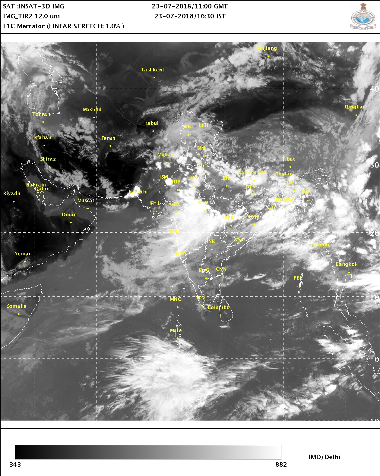
Bay of Bengal Depression System has tracked West Northwestwards towards Jharkhad/M.P and has weakened into a Well Marked Low Pressure area and now lies over Northeast Madhya Pradesh and neighborhood. Associated Cyclonic Circulation extends up to 5.8 km above mean sea level tilting Southwards with height.
The Axis of Monsoon trough at mean sea level now passes through Bikaner, Jaipur, Gwalior, Sidhi, Center of the Well Marked Low Pressure area over Northeast M.P. & neighborhood and thence to Northeast Bay of Bengal.
There is a UAC over Northeast Rajasthan and adjoining Haryana at 1.5 km above mean sea level.
Saurashtra, Gujarat & Kutch: 23rd to 27th July 2018
The Bay of Bengal System will track towards North M.P. and neighboring U.P. and Delhi. The UAC of this System is expected to be over North M.P. Under the influence of the UAC, there is a good chance of rainfall over Gujarat Districts bordering Rajasthan/M.P. and to a less extent over rest of North Gujarat & East Central Gujarat during 23rd to 27th July 2018. South Gujarat is also expected to get rain during this forecast period. Saurashtra & Kutch expected to get less benefit due to less humidity at 3.1 km level over parts of Saurashtra & Kutch.
North Gujarat Districts bordering Rajasthan & East Central Gujarat Districts bordering Madhya Pradesh expected to receive 50 mm to 80 mm rainfall during the forecast period along with South Gujarat.
Rest of the Districts of North Gujarat, East Central Gujarat expected to receive 25 mm to 50 mm rainfall during the forecast period.
Saurashtra & Kutch expected to get scattered showers/light rain and isolated medium rain on some days of the forecast period.
Windy and Cloudy weather conditions expected over Saurashtra on most days. Windy conditions for Kutch on most days.
Caution: Please refer/rely on IMD/RSMC Bulletins/Advisories for Storms & Weather related matter.
હાલ ની પરિસ્થિતિ અને નિચોડ: 23 જુલાઈ 2018
બંગાળ ની ખાડી ની ડિપ્રેસન સિસ્ટમ ઝારખંડ બાજુ ગતિ કરેલ આજે નબળી પડી હવે વેલ માર્કંડ લો છે જે નોર્થઇસ્ટ એમપી ઉપર છે. તેના અનુંસંગિક યુએસી 5.8 કિમિ ની ઊંચાઈ સુધી છે અને વધતી ઊંચાઈએ દક્ષિણ તરફ ઝુકે છે.
ચોમાસુ ધરી બિકાનેર,જયપુર, ગ્વાલિયર , સીધી, વેલ માર્કંડ લો નું સેન્ટર, અને ત્યાંથી નોર્થઇસ્ટ બંગાળ ની ખાડી સુધી લંબાય છે.
એક યુએસી 1.5 કિમિ ના લેવલ પર નોર્થઇસ્ટ રાજસ્થાન અને લાગુ હરિયાણા નજીક છવાયેલ છે.
સૌરાષ્ટ્ર માં પવન નું જોર રહેશે અને લગભગ દિવસો વાદળ છાયું વાતાવરણ રહેશે. કચ્છ માં પણ પવન નું જોર રહેશે.
વરસાદ ના આંકડા, ડેમ ઉપર વરસાદ ના આંકડા તેમજ ડેમ સ્ટોરેજ ની વિગત ઉપર લિંક માં આપેલ છે
સૌરાષ્ટ્ર, ગુજરાત અને કચ્છ: તારીખ 23 જુલાઈ થી 27 જુલાઈ 2018
બંગાળ ની ખાડી ની સિસ્ટમ હાલ વેલ માર્કંડ લો છે જે નોર્થ એમપી /યુપી તરફ ગતિ કરે છે. અનૂસંગિક યુએસી નોર્થ એમપી પર આવશે જેની અસર થી રાજસ્થાન બોર્ડર ને લાગુ નોર્થ ગુજરાત ના જિલ્લા ઓ તેમજ એમપી બોર્ડર ને લાગુ ગુજરાત ના જિલ્લાઓ માં તેમજ દક્ષિણ ગુજરાત માં સારા વરસાદ ની શક્યતા છે. બાકી ના નોર્થ/મધ્ય ગુજરાત માં પણ વરસાદ ની શક્યતા છે. સૌરાષ્ટ્ર કચ્છ ઓછો ફાયદો છે કારણ કે 3.1 કિમિ ના લેવલ માં ભેજ અમૂક વિસ્તાર માં ઓછો છે.
આગાહી સમય માં રાજસ્થાન ને લાગુ નોર્થ ગુજરાત ના જિલ્લાઓ માં, એમપી બોર્ડર ને લાગુ મધ્ય પૂર્વ ગુજરાતના જિલ્લાઓ અને દક્ષિણ ગુજરાત માં 50 મીલીમીટર થી 80 મીલીમીટર વરસાદ ની શક્યતા છે.
આગાહી સમય માં મધ્ય ગુજરાત ના બાકી ના જિલ્લાઓ તેમજ નોર્થ ગુજરાત ના બાકી ના જિલ્લાઓ માં 25 મીલીમીટર થી 50 મીલીમીટર વરસાદ ની શક્યતા છે.
આગાહી સમય માં સૌરાષ્ટ્ર અને કચ્છ માં છુટા છવાયા ઝાપટા, હળવો વરસાદ અને ક્યાંક ક્યાંક મધ્યમ વરસાદ આગાહી ના અમૂક દિવસો માં શક્યતા છે.
સાવચેતી:
સ્ટોર્મ કે હવામાન અંગે ની માહિતી માટે ભારતીય હવામાન ખાતા/ગવર્મેન્ટ ના બુલેટીન/સુચના પર નિર્ભર રહેવું.