Update on 12th July 2018
Average rainfall over whole Gujarat for this season is 22.86 % till 12th July 2018
Area wise average rainfall over different parts of Gujarat for this season is as under:
South Gujarat 38.35 %
Central Gujarat 20.71 % where Ahmadabad District is just 7.89 %
North Gujarat 12.00% where Banaskantha is just 5.85 %
Saurashtra 12.77% where Dev Bhumi District is just 1.9% & Surendranagar District is 3.93 %
Kutch 1.25%
Current Meteorological features based on IMD Bulletin :
The Axis of Monsoon trough at mean sea level continues to pass through Anupgarh, Jhunghunu, Shivpuri, Sidhi, Pendra, Chaibasa, Digha and thence East Southeastwards to East Central Bay of Bengal extending up to 0.9 km above mean sea level. Western end of Axis of Monsoon could track Southwards on some days during the forecast period but at different height.
The Cyclonic Circulation over NE Madhya Pradesh is now over South U.P. and neighborhood extending up to 1.5 km above mean sea level.
The Cyclonic Circulation over North Coastal Odisha and neighborhood now extends up to 5.8 km above mean sea level tilting Southwestwards with height. A Low Pressure area is very likely to form over North Bay of Bengal and neighborhood from this UAC.
The East West shear zone running roughly along latitude 21°N at 3.1 km above mean sea level & along latitude 20°N at 4.5 km above mean sea level. This shear zone will be present on multiple days at different Latitudes inn vicinity of Gujarat State.
The off-shore trough at mean sea level off Karnataka to Kerala coasts persists.
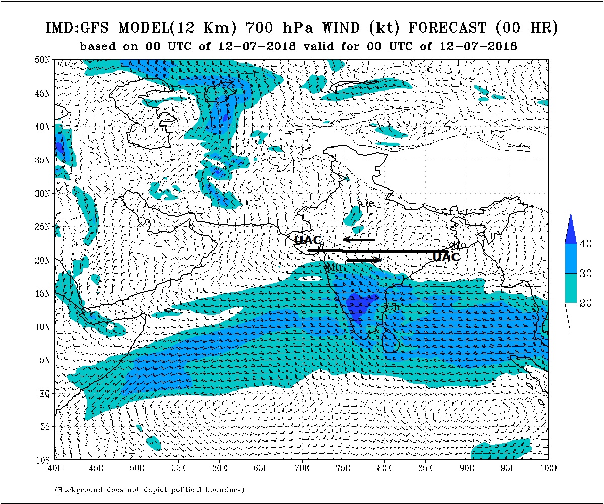
The Cyclonic Circulation is now over Saurashtra and adjoining Arabian Sea/Gujarat at 3.1 km above mean sea level and is expected to remain in a broad region of Saurashtra, Kutch, Gujarat and adjoining Arabian Sea during the forecast period for 4 to 5 days in various strength.
IMD Charts have been marked with UAC & East West shear zone.
Saurashtra, Gujarat & Kutch: 12th to 19th July 2018
South Gujarat & Central Gujarat expected to receive fairly widespread light/medium/heavy rain with very heavy rain in isolated places on some days days of the forecast period.
North Gujarat expected to receive rainfall in phases over different areas with cumulative totals of 50 mm to 80 mm during the period up to 19th July 2018.
60% areas of Saurashtra expected to receive rainfall in phases over different areas with cumulative totals of 50 mm to 80 mm during the period up to 19th July 2018. Isolated places could receive more than 100 mm rain cumulative
Rest 40% areas of Saurashtra & Kutch expected to receive rainfall in phases over different areas with cumulative totals of 35 mm to 50 mm during the period up to 19th July 2018. Rainfall of Kutch has been derived from various differing forecasts having rainfall from 20 mm to 60 mm.
Note: 25 mm is approximately 1 inch old measure.
Caution: Please refer/rely on IMD/RSMC Bulletins/Advisories for Storms & Weather related matter.
હાલ ની પરિસ્થિતિ અને નિચોડ: 12 જુલાઈ 2018
ચોમાસુ ધરી અનૂપગઢ, ઝૂનઝૂનુ, શિવપુરી, સીધી, પેન્દ્રા, પુરી, દીઘા અને મધ્ય પૂર્વ બંગાળ ની ખાડી સુધી લંબાય છે જે સી લેવલ થી 0.75 કિમિ ઉંચાઈ સુધી ફેલાયેલ છે. આગાહી સમય માં ચોમાસુ ધરી નો પશ્ચિમ છેડો દક્ષિણ તરફ સરકે તેવું છે જોકે જુદી ઉચાઈએ.
લો પ્રેસર થયેલ તેનું યુએસી હાલ દક્ષિણ યુ.પી. આસપાસ છે આસપાસ 1.5 કિમિ ઉંચાઈ સુધી છે.
નવું યુએસી નોર્થ ઓડિશા ના દરિયા કિનારા નજીક છે જે 5.8 કિમિ ની ઉંચાઈ સુધી ફેલાયેલ છે અને વધતી ઉંચાઈએ દક્ષિણ પશ્ચિમ તરફ ઝુકે છે. આ યુએસી માંથી બંગાળની ખાડીનું લો થવાનું છે.
ઇસ્ટ વેસ્ટ શિયર ઝોન latitude 20°N પર 4.5 કિમિ ઉપર છે. જે અરબી સમુદ્ર થી ઓડિશા ના યુએસી સુધી છે. તેમજ ઇસ્ટ વેસ્ટ શિયર ઝોન latitude 21°N પર 3.1 કિમિ ઉપર છે. જે સૌરાષ્ટ્ર થી ઓડિશા ના યુએસી સુધી છે.
ઓફ શોર ટ્રફ સી લેવલ પર કર્ણાટક થી કેરળ દરિયા નજીક છે.
એક યુએસી સૌરાષ્ટ્ર અને લાગુ અરબી સમુદ્ર અને લાગુ ગુજરાત પર 3.1 કિમિ ની ઉચાઈએ છે. આ યુએસી આગાહી સમય ના 4 થી 5 દિવસ સૌરાષ્ટ્ર, કચ્છ ગુજરાત અને લાગુ અરબી સમુદ્ર આસપાસ ઓછા વધતા પ્રમાણ માં રહેશે.
તારીખ 12 જુલાઈ સુધી ગુજરાત ના વરસાદ ના પ્રમાણ અંગે નું ટૂંકું અપડેટ ઉપર ઈંગ્લીશ માં છે.
સૌરાષ્ટ્ર, ગુજરાત અને કચ્છ: તારીખ 12 જુલાઈ થી 19 જુલાઈ 2018
દક્ષિણ ગુજરાત અને મધ્ય ગુજરાત માં ઘણા વિસ્તાર માં હળવો/મધ્યમ/ભારે વરસાદ અને ક્યારેક અતિ ભારે વરસાદ આગાહી સમય ના અમૂક દિવસો પડવાની શક્યતા છે.
નોર્થ ગુજરાત માં આગાહી સમય દરમિયાન ની કુલ માત્રા 40 મીલીમીટર થી 80 મીલીમીટર અલગ અલગ દિવસે અને તબકાવાર વિસ્તારો માં કુલ વરસાદ ની સંભાવના.
સૌરાષ્ટ્ર ના 60% વિસ્તાર માં આગાહી સમય દરમિયાન ની કુલ માત્રા 50 મીલીમીટર થી 80 મીલીમીટર અલગ અલગ દિવસે અને તબકાવાર વિસ્તારો માં કુલ વરસાદ ની સંભાવના. આમાં છુટા છવાયા વિસ્તાર માં 100 મીલીમીટર થી પણ વધુ ની સંભાવના છે.
બાકી ના 40% સૌરાષ્ટ્ર ના વિસ્તાર માં અને કચ્છ માં આગાહી સમય દરમિયાન ની કુલ માત્રા 35 મીલીમીટર થી 50 મીલીમીટર અલગ અલગ દિવસે અને તબકાવાર વિસ્તારો માં કુલ વરસાદ ની સંભાવના.
નોંધ: 25 મીલીમીટર એટલે આશરે જુના માપ પ્રમાણે 1 ઇંચ
સાવચેતી:
સ્ટોર્મ કે હવામાન અંગે ની માહિતી માટે ભારતીય હવામાન ખાતા/ગવર્મેન્ટ ના બુલેટીન/સુચના પર નિર્ભર રહેવું.
