Current Weather Conditions on 15th June 2018
As per IMD :
The Northern Limit of Monsoon (NLM) continues to pass through Lat. 19°N/ Long. 60°E, Lat. 19°N/ Long. 70°E, Thane (including Mumbai), Ahmednagar, Buldhana, Amraoti, Gondia,Titlagarh, Cuttack, Midnapore, Lat. 24°N/ Long. 89°E, Goalpara, Baghdogra and Lat. 27°N/ Long. 87°E. Further advance of southwest monsoon is not likely during next one weak due to the likely prevalence of weak monsoon pattern.
Strong dust raising winds of the order of 25-35 kmph likely to continue over Rajasthan, Punjab, Haryana, Chandigarh & Delhi and West Uttar Pradesh during next 24 hours. The density of dust loading is likely to decrease from today evening, with the likely development of weather systems leading to thundershowers over parts of northwest India.
IMD Advance Of Southwest Monsoon Map (click ‘Latest Advance for Latest Map)
Advance till 15-06-2018
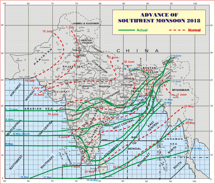
Latest Advance Map

Advance till 15-06-2018
Latest Advance Map
સૌથી ઉપર ની લીલી લીટી ના છેડે જે તારીખ હોઈ તે તારીખે લીટી ની નીચે ના ભાગ માં બધે ચોમાસું પોંચી ગયું છે તેમ સમજવું.
લાલ ત્રુટક લીટી જે તે વિસ્તાર માં નોર્મલ ચોમાસું બેસવાની તારીખ દર્શાવે છે
The date shown at the end of green line shows that the Southwest Monsoon has set in over areas below the green line on that date.
The red dashed line shows the normal date of onset of Southwest Monsoon over various regions
હાલ ની પરિસ્થિતિ અને નિચોડ:
હાલ ની પરિસ્થિતિ અને નિચોડ:
ચોમાસુ દેશ લેવલે સ્થગિત છે. ચોમાસુ રેખા હાલ 400 થી 500 કિમિ નોર્મલ થી પાછળ રહી ગઈ છે.
એક નવું વેસ્ટર્ન ડિસ્ટર્બન્સ નો ટ્રફ રૂપે 64એ અને 34 ન ઉપર 5.8 કિમિ ની ઉંચાઇએ છે.
એક યુએસી છે જે પંજાબ અને લાગુ પાકિસ્તાન ઉપર એક યુએસી છે જે 1.5 કિમિ ની ઉંચાઇએ છે.
ઓફશોર ટ્રફ કર્ણાટક થી કેરળ સુધી સી લેવલ ઉપર છે.
પવન નું જોર વધુ છે.
ગરમી નોર્મલ નજીક છે. ભેજ ને હિસાબે બફારો લાગે પણ પવન ને હિસાબે થોડો ફરક પડે છે. ભાવનગર માં ગરમી 40.8 C હતી જે નોર્મલ થી 3 સC ઉંચુ ગણાય. બાકી સેન્ટરો માં નોર્મલ નજીક તાપમાન હતું.
સૌરાષ્ટ્ર, ગુજરાત અને કચ્છ: તારીખ 15 જૂન થી 22 જૂન 2018
આવતા ચારેક દિવસ છુટા છવાયા ઝાપટા/ હળવો વરસાદ થવાની શક્યતા છે, ખાસ કરીને દક્ષિણ સૌરાષ્ટ્ર અને દક્ષિણ ગુજરાત બાજુ. હાલ સાર્વત્રિક મોટો વરસાદ ના સંજોગો નથી. 10 દિવસ થયા પવનો ઝડપી ફૂંકાય છે. આ પવનો દક્ષિણ પશ્ચિમ તરફ થી ફૂંકાય છે જે 17 તારીખ સુધી વધુ રહેશે ત્યાર બાદ થોડી રાહત બેક દિવસ અને ફરી થોડો પવન માં વધારો થશે. હાલ નોર્થ વેસ્ટ ઇન્ડિયા માં 990 મીલીબર (નોર્મલ 995 મીલીબાર) અને અરબી સમુદ્ર માં 1010 મીલીબર પ્રેસર છે જેથી ગ્રેડિયન્ટ (તફાવત) નોર્મલ થી વધુ છે એટલે પવન વધુ ફૂંકાય છે. તાપમાન માં નોર્મલ નજીક રહે ક્યારેક થોડું નીચું પણ થાય. નીચા લેવલ માં ભેજ સારો છે 0.75 કિમિ અને 1.5 કિમિ ની ઉંચાયે, પરંતુ 3.1 કિમિ ની ઉંચાયે પવન અતિ સૂકા છે.
ચોમાસા નું હાલ નું તારણ :
ચોમાસા ની આગેકૂચ દેશ લેવલે આવતા પાંચ સાત દિવસ સ્થગિત રહેશે.
Current Situation and Conclusions:
There is an Off-shore Monsoon trough at sea level along Karnataka to Kerala Coast.
There is an Upper Air Cyclonic Circulation over Punjab and adjoining Pakistan at 1.5 km above mean sea level.
There is a fresh Western Disturbance as a trough at 5.8 km above mean sea level along Long. 64°E to the North of Lat. 32°N.
Saurashtra, Gujarat & Kutch: 15th to 22nd June 2018
Winds are mainly blowing from Southwest & Westerly direction and will continue to blow during the forecast period, due to higher pressure gradient between Northwest India and Arabian Sea at 10N. High winds till 17th June and 18th/19th it would decrease and again pick up after on 21st/22nd June. Scattered showers/light rain expected mainly over South Saurashtra & South Gujarat next four days and then intermittent during the rest of forecast period. Widespread meaningful rainfall possibility is limited during this period. Temperature will be near normal to slightly below normal on some days. Low level humidity is high, however the higher level (3.1 km above mean sea level) air is dry.
Overall Monsoon Situation:
Advance of Southwest Monsoon expected to remain dormant for at least next five to seven days. The current Northern Limit of Monsoon line is about 400 to 500 km behind Normal Onset schedule. Good rainfall expected over Western Indian coast from Konkan to Kerala and over Northeastern States.
Caution: Please refer/rely on IMD/RSMC Bulletins/Advisories for Storms & Weather related matter.
સાવચેતી:
સ્ટોર્મ કે હવામાન અંગે ની માહિતી માટે ભારતીય હવામાન ખાતા/ગવર્મેન્ટ ના બુલેટીન/સુચના પર નિર્ભર રહેવું.

