Current Weather Conditions on 9th June 2018
As per IMD :
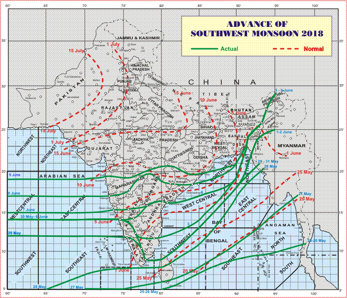
Southwest Monsoon has further advanced into most parts of Central Arabian Sea, most parts of Konkan, some more parts Madhya Maharashtra, Marathawada, Vidarbha, Chhattisgarh, Odisha and Northwest Bay of Bengal. The Northern Limit of Monsoon (NLM) passes through Lat. 19°N/Long. 60°E, Lat. 19°N/ Long. 70°E, Thane (including Mumbai), Ahmednagar, Parbhani, Yeotmal, Brahmapuri, Rajnandgaon, Bhavanipatna, Puri, Lat. 21°N/ Long. 90°E, Agartala, Lumding, North Lakhimpur and Lat. 29°N/ Long. 95°E. Conditions are becoming favorable for further advance of Southwest Monsoon into some more parts of Chhattisgarh, Odisha, some parts of West Bengal & Sikkim, remaining parts of northwest Bay of Bengal and Northeastern States during next 48 hours. Conditions are likely to become favorable for further advance of Southwest Monsoon into some more parts of West Bengal, Odisha and some parts of Jharkhand and Bihar during the subsequent 48 hours.
IMD Advance Of Southwest Monsoon Map (click ‘Latest Advance for Latest Map)
Advance till 09-06-2018
Latest Advance Map

Advance till 09-06-2018
Latest Advance Map
સૌથી ઉપર ની લીલી લીટી ના છેડે જે તારીખ હોઈ તે તારીખે લીટી ની નીચે ના ભાગ માં બધે ચોમાસું પોંચી ગયું છે તેમ સમજવું.
લાલ ત્રુટક લીટી જે તે વિસ્તાર માં નોર્મલ ચોમાસું બેસવાની તારીખ દર્શાવે છે
The date shown at the end of green line shows that the Southwest Monsoon has set in over areas below the green line on that date.
The red dashed line shows the normal date of onset of Southwest Monsoon over various regions
હાલ ની પરિસ્થિતિ અને નિચોડ:
બંગાળ ની ખાડી નું લો પ્રેસર હાલ ઉત્તર પૂર્વ બંગાળ ની ખાડી માં બાંગ્લાદેશ ના કિનારા નજીક છે જે વેલ માર્કંડ થઇ શકે 24 કલાક માં.
પૂર્વ પશ્ચિમ ટ્રફ પંજાબ થી બંગાળની ખાડી ના લો પ્રેસર સેન્ટર સુધી 1.5 કિમિ ની ઊંચા સુધી લંબાય છે, જે હરિયાણા, ઉત્તર પૂર્વ રાજસ્થાન, દક્ષિણ યુપી, ઝારખંડ, વેસ્ટ બંગાળ પર થી પાસ થાય છે.
ઓફ શોર ટ્રફ નોર્થ મહારાષ્ટ્ર થી કેરળ સુધી શક્રિય છે.
નોર્થ કર્ણાટક, દક્ષિણ કોંકણ અને ગોઆ કિનારા નજીક એક યુએસી 3.1 કિમિ અને 5.8 કિમિ ની ઉંચાયે હતું જે હવે 5.8 કિમિ ની ઉંચાયે છે.
સૌરાષ્ટ્ર, ગુજરાત અને કચ્છ: તારીખ 9 જૂન થી 16 જૂન 2018
ત્રણેક દિવસ થયા પવનો ઝડપી ફૂંકાય છે. આ પવનો દક્ષિણ પશ્ચિમ અને પશ્ચિમ ના ફૂંકાવાનું આગાહી સમય દરમિયાન ચાલુ રહેશે અને ક્યારેક હાલ ની ઝડપ કરતા પણ વધુ ઝડપે ફૂંકાશે. હાલ સાર્વત્રિક મોટો વરસાદ ના સંજોગો નથી. છુટા છવાયા ઝાપટા/ હળવો વરસાદ આગાહી દરમિયાન ચાલુ રહેશે અને વિસ્તાર વધશે. તાપમાન માં નોર્મલ નજીક રહે ક્યારેક થોડું વધુ. આગાહી ના પાછળ દિવસો માં તાપમાન થોડું ઘટશે. ગુજરાત માં તાપમાન સૌરાષ્ટ્ર કરતા વધુ રહેશે. નીચા લેવલ માં ભેજ સારો છે 0.75 કિમિ અને 1.5 કિમિ ની ઉંચાયે, પરંતુ 3.1 કિમિ ની ઉંચાયે પવન અતિ સૂકા છે.
ચોમાસા નું હાલ નું તારણ :
ચોમાસા ની બંગાળ ની પાંખ અરબી પાંખ કરતા વધુ ગતિશીલ રહેશે આવતા 4 દિવસ.
Current Situation and Conclusions:
The is a Low Pressure area is now over Northeast Bay of Bengal and adjoining Bangladesh Coast. Associated Cyclonic Circulation extends up to Mid-tropospheric levels. It is likely to become Well Marked during next 24 hours.
An East-West trough runs from Punjab to the Center of Low Pressure over North East Bay of Bengal across South Haryana, Northeast Rajasthan, South U.P.. Jharkhand, and West Bengal extending up to 1.5 km above mean sea level.
The Off-shore Monsoon trough now runs from North Maharashtra to Kerala.
There is a UAC was a UAC at 3.1 to 5.8 km above mean sea level off South Konkan, Goa, North Karnataka coast yesterday. Now the UAC exists at 5.8 km above mean sea level.
Saurashtra, Gujarat & Kutch: 9th to 16th June 2018
Winds are mainly blowing from Southwest & Westerly direction and will continue to blow during the forecast period. Pre-monsoon activity will continue with scattered showers/light rain over more area of Saurashtra, Kutch & Gujarat during the forecast period. Widespread meaningful rainfall possibility is limited during this period. Temperature will be near normal to slightly above normal on some days. Temperature over Gujarat will be higher than Saurashtra. Temperature expected to decline during latter part of forecast period. Low level humidity is high, however the higher level (3.1 km above mean sea level) air is dry.
Overall Monsoon Situation:
The Bay of Bengal branch of Monsoon expected to be active compared to the Arabian branch henceforth for next four days.

Caution: Please refer/rely on IMD/RSMC Bulletins/Advisories for Storms & Weather related matter.
સાવચેતી:
સ્ટોર્મ કે હવામાન અંગે ની માહિતી માટે ભારતીય હવામાન ખાતા/ગવર્મેન્ટ ના બુલેટીન/સુચના પર નિર્ભર રહેવું.

