Current Weather Conditions on 29th May 2018
As per IMD:
Southwest Monsoon has further advanced remaining parts of Southeast Arabian Sea, Comorin-Maldives area, entire Lakshadweep, most parts of Kerala, some parts of Tamilnadu and some more parts of southwest , central & northeast Bay of Bengal. Thus the southwest monsoon has set in over Kerala., today the 29th May, 2018. The Northern Limit of Monsoon (NLM) passes through Lat. 12°N/Long. 60°E, Lat. 12°N/ Long. 65°E, Lat. 12°N/ Long. 70°E, Kannur, Coimbatore, Kodaikanal, Tuticorin, Lat. 09°N/Long. 80°E, Lat. 13°N/Long. 85°E, Lat. 18°N/Long 90°E and Lat.21°N/Long. 93°E . Conditions are favourable for further advance of Southwest Monsoon into some parts of central Arabian Sea, remaining parts of Kerala; some parts of coastal & south interior Karnataka, some more parts of eastcentral & northeast Bay of Bengal and some parts of northeastern states during next 48 hours.
IMD Advance Of Southwest Monsoon Map
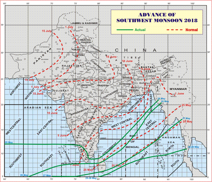
સૌથી ઉપર ની લીલી લીટી ના છેડે જે તારીખ હોઈ તે તારીખે લીટી ની નીચે ના ભાગ માં બધે ચોમાસું પોંચી ગયું છે તેમ સમજવું.
લાલ ત્રુટક લીટી જે તે વિસ્તાર માં નોર્મલ ચોમાસું બેસવાની તારીખ દર્શાવે છે
The date shown at the end of green line shows that the Southwest Monsoon has set in over areas below the green line on that date.
The red dashed line shows the normal date of onset of Southwest Monsoon over various regions
હાલ ની પરિસ્થિતિ અને નિચોડ:
આજે ચોમાસુ કેરળ અને તામિલનાડુ માં પહોંચ્યું.
દક્ષિણ પૂર્વ અરબી સમુદ્ર માં કેરળ/કર્ણાટક ના કિનારા નજીક વેલ માર્કંડ લો પ્રેસર છે.
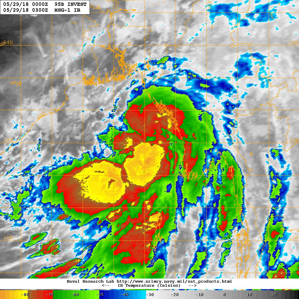
મધ્ય પૂર્વ બંગાળ ની ખાડી માં જે વેલ માર્કંડ લો પ્રેસર હતું તે હાલ ડિપ્રેસન ની માત્રા એ પહોંચ્યું છે.
Salient Weather Conditions:
Southwest Monsoon covers most parts of Kerala & some parts of Tamilnadu today.
The Well Marked Low Pressure area over Southeast Arabian sea off Kerala-Karnataka coasts and associated Cyclonic Circulation extending up to 7.6 km above mean sea level persists.
The Well Marked Low Pressure over East Central Bay of Bengal & neighborhood with associated Cyclonic Circulation extending up to 5.8 km above mean sea level has now concentrated to Depression strength.
There is an East-West shear zone along Lat. 12 °N at 3.1 km above mean sea level over Indian Region.
Posted IMD Bulletin No. 01 (BOB 01/2018) here below at 1630 IST
INDIA METEOROLOGICAL DEPARTMENT
BULLETIN NO. : 01 (BOB 01/2018)
TIME OF ISSUE: 1500 HOURS IST DATED: 29.05.2018
Depression over Northeast and adjoining East Central Bay of Bengal
Here below is a three page Document. Click Page Up Down arrows at the bottom left corner on the Document page to read all the pages.
indian_1527610386
NRL IR Satellite Image of 95B.INVEST ( Depression)
on 29th May 2018 @ 0300 UTC ( 08.30 am. IST)
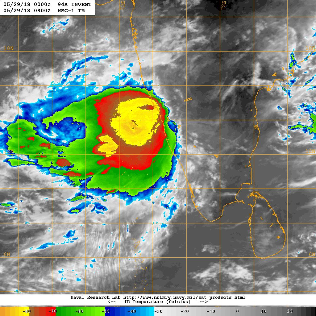
NRL IR Satellite Image of 94A.INVEST ( Well Marked Low Pressure)
on 29th May 2018 @ 0300 UTC ( 08.30 am. IST)
Caution: Please refer/rely on IMD/RSMC Bulletins/Advisories for Storms & Weather related matter.
સાવચેતી:
સ્ટોર્મ કે હવામાન અંગે ની માહિતી માટે ભારતીય હવામાન ખાતા/ગવર્મેન્ટ ના બુલેટીન/સુચના પર નિર્ભર રહેવું.