Current Weather Conditions on 28th May 2018
As per IMD:
Southwest Monsoon has further advanced into some more parts of Southeast Arabian Sea, Maldives-Comorin area and southwest Bay of Bengal, most parts of southeast Bay of Bengal, remaining parts of Andaman Sea, Andaman & Nicobar Islands, many parts of eastcentral Bay of Bengal and some parts of westcentral and northeast Bay of Bengal. The Northern Limit of Monsoon (NLM) passes through Lat. 5°N/Long. 65°E, Lat. 7°N/Long. 70°E, Lat. 8°N/Long. 80°E, Lat. 11°N/Long. 85°E, Lat. 17°N/Long 90°E, and Lat.20°N/Long. 93°E .
Conditions are becoming favourable for further advance of Southwest Monsoon into some more parts of South Arabian Sea, remaining parts of Comorin-Maldives area; some parts of Lakshadweep, Kerala and Tamilnadu, some more parts of Southwest, central and northeast Bay of Bengal during next 24 hours. Also, conditions are likely to become favaourable for further advance of southwest monsoon into remaining parts of south Arabian Sea, some parts of central Arabian Sea, remaining parts of Kerala, some parts of coastal and interior Karnataka and some parts of Tamilnadu, southwest, central and northeast Bay of Bengal and some parts of northeastern states during next 2-3 days.
IMD Advance Of Southwest Monsoon Map
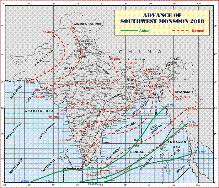
સૌથી ઉપર ની લીલી લીટી ના છેડે જે તારીખ હોઈ તે તારીખે લીટી ની નીચે ના ભાગ માં બધે ચોમાસું પોંચી ગયું છે તેમ સમજવું.
લાલ ત્રુટક લીટી જે તે વિસ્તાર માં નોર્મલ ચોમાસું બેસવાની તારીખ દર્શાવે છે
The date shown at the end of green line shows that the Southwest Monsoon has set in over areas below the green line on that date.
The red dashed line shows the normal date of onset of Southwest Monsoon over various regions
હાલ ની પરિસ્થિતિ અને નિચોડ:
દક્ષિણ પશ્ચિમ ચોમાસુ દક્ષિણ પૂર્વ અરબી સમુદ્ર ના ભાગો, માલદિવ્સ કોમોરીન ના બાકી ના ભાગો માં , સમગ્ર આંદામાન દરિયા અને બંગાળ ની ખાડી ના થોડા વધુ ભાગો માં આગળ ચાલ્યું. કેરળ ના દ્વાર સુધી પહોંચ્યું.
આવતા 24 કલાક માં ચોમાસુ કેરળ અને તામિલનાડુ પહોંચે તેવી શક્યતા છે.
દક્ષિણ પૂર્વ અરબી સમુદ્ર માં કેરળ/કર્ણાટક ના કિનારા નજીક લો પ્રેસર હવે વેલ માર્કંડ થયું છે.
મધ્ય પૂર્વ બંગાળ ની ખાડી માં એક લો પ્રેસર થયું છે જે વેલ માર્કંડ ની માત્રા એ પહોંચ્યું છે.
Other Salient Weather Conditions:
The Well Marked Low Pressure area over Southeast Arabian sea off Kerala-Karnataka coasts and associated Cyclonic Circulation extending up to 7.6 km above mean sea level persists.
Another Low Pressure area over East Central Bay of Bengal & neighborhood with associated Cyclonic Circulation extending up to 5.8 km above mean sea level has now become Well Marked.
There is an East-West shear zone along Lat. 12 °N at 3.1 km above mean sea level over Indian Region.
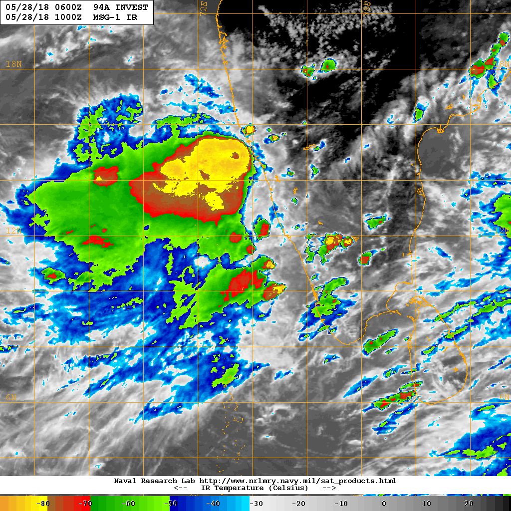
NRL IR Satellite Image of 94A.INVEST ( Well Marked Low Pressure)
on 28th May 2018 @ 1000 UTC ( 03.30 pm. IST)
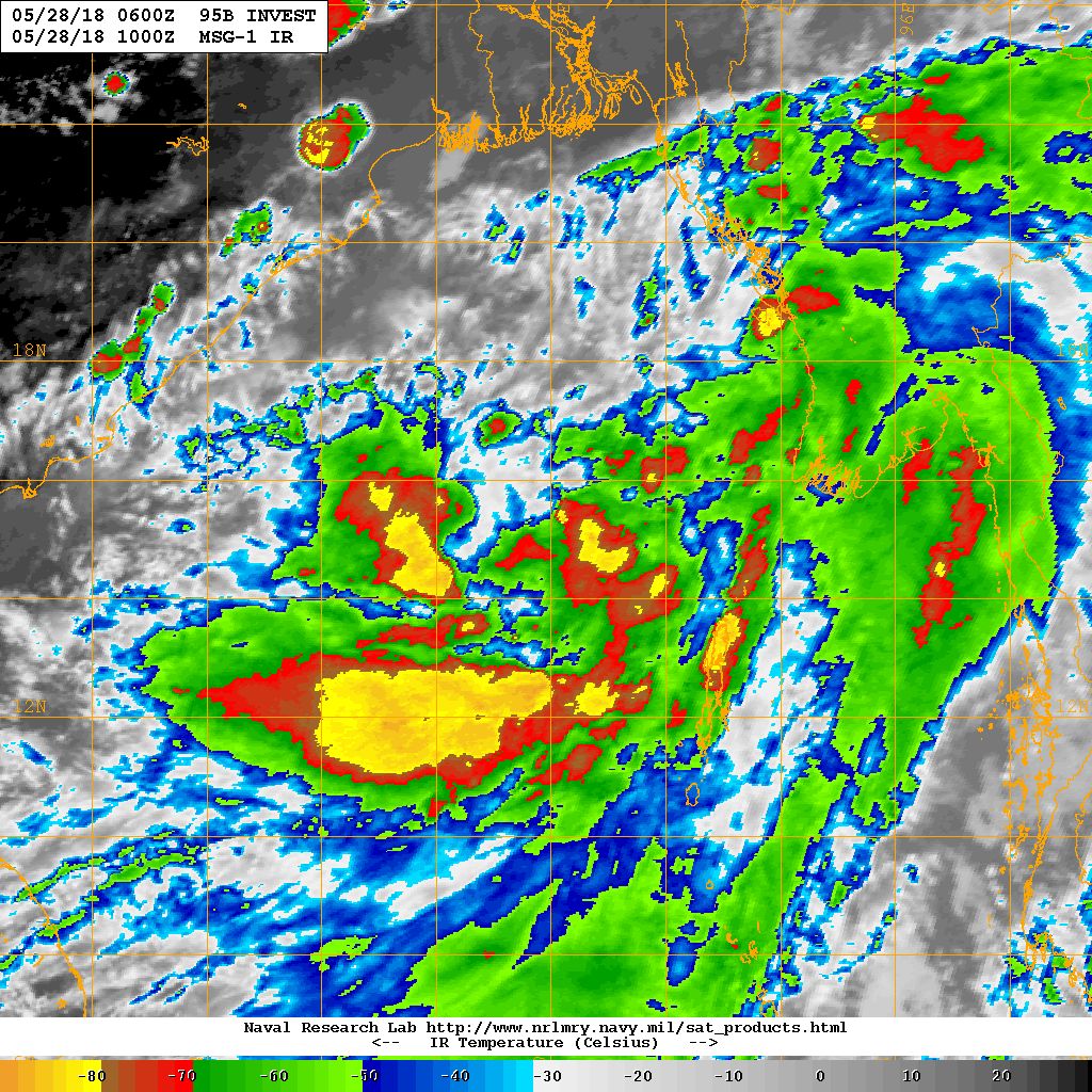
NRL IR Satellite Image of 95B.INVEST ( Well Marked Low Pressure)
on 28th May 2018 @ 1000 UTC ( 03.30 pm. IST)
Caution: Please refer/rely on IMD/RSMC Bulletins/Advisories for Storms & Weather related matter.
સાવચેતી:
સ્ટોર્મ કે હવામાન અંગે ની માહિતી માટે ભારતીય હવામાન ખાતા/ગવર્મેન્ટ ના બુલેટીન/સુચના પર નિર્ભર રહેવું.