Current Weather Conditions on 19th July 2017
Monsoon Status based on IMD Inferences:
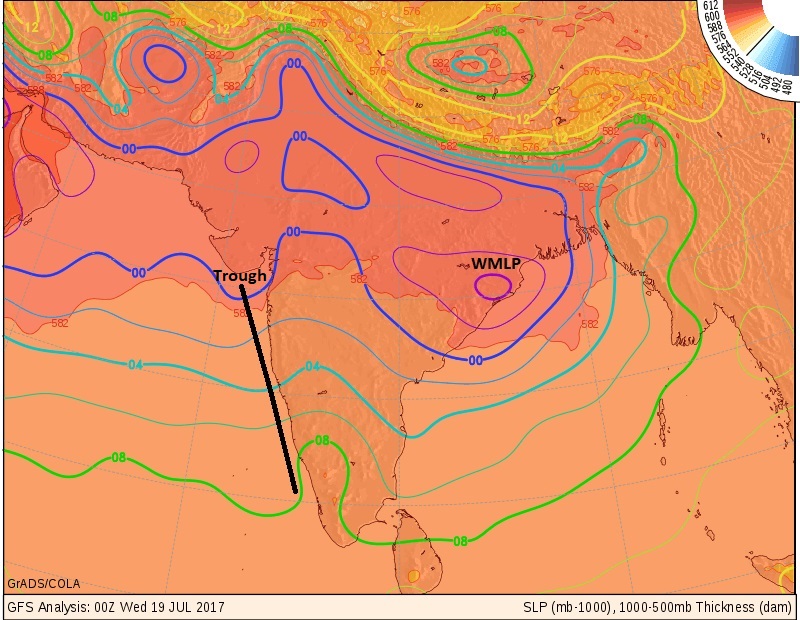
The Well Marked Low Pressure over Northwest Bay of Bengal has strengthened yesterday to a Depression. Subsequently this morning it has tracked over to Odisha vicinity of Puri and has weakened to a Well Marked Low Pressure again.
The trough at mean sea level runs from Southwest Rajasthan to Eastcentral Bay of Bengal across Madhya Pradesh, Chhattishgarh, Center of Well Marked Low Pressure area over Odisha.
The remnant of the last Low Pressure is yet prevailing as an Upper Air Cyclonic Circulation at 3.1 km above mean sea level over Northeast Arabian Sea close to Saurashtra & Kutch.
UAC at a lower level of 1.5 km above mean sea level is over whole Gujarat and adjoining Arabian Sea
There is a trough over Saurashtra and off-shore trough at mean sea level extends from South of Saurashtra to North Kerala coast.
બંગાળ ની ખાડી ની સિસ્ટમ ડિપ્રેસન હતી તે હવે નબળી પડી ને વેલ માર્કંડ લો પ્રેસર છે જે ઓડિશા ઉપર આવી ગઈ છે.
ટ્રફ દક્ષિણ પશ્ચિમ રાજસ્થાન થી મધ્ય પૂર્વ બંગાળ ની ખાડી સુધી લંબાય છે વાયા એમ.પી. છતીશગઢ ઓડિશા ના વેલ માર્કંડ લો પ્રેસર.
આગળ ના લો પ્રેસર ની વધઘટ નું યુએસી 3.1 કિમિ ના લેવલે સૌરાષ્ટ્ર/કચ્છ લાગુ અરબી સમુદ્ર ઉપર છે.
1.5 કિમિ લા લેવલે યુએસી છે જે સમગ્ર ગુજરાત અને લાગુ અરબી સમુદ્ર ઉપર છવાયેલ છે.
સૌરાષ્ટ્ર ઉપર દરિયા ની સપાટી લેવલે એક ટ્રફ છે અને ઑફ શોર ટ્રફ સૌરાષ્ટ્ર ની દક્ષિણે થી ઉત્તર કેરળ સુધી લબાય છે.
As per IMD:
IMD Advance Of Southwest Monsoon Map
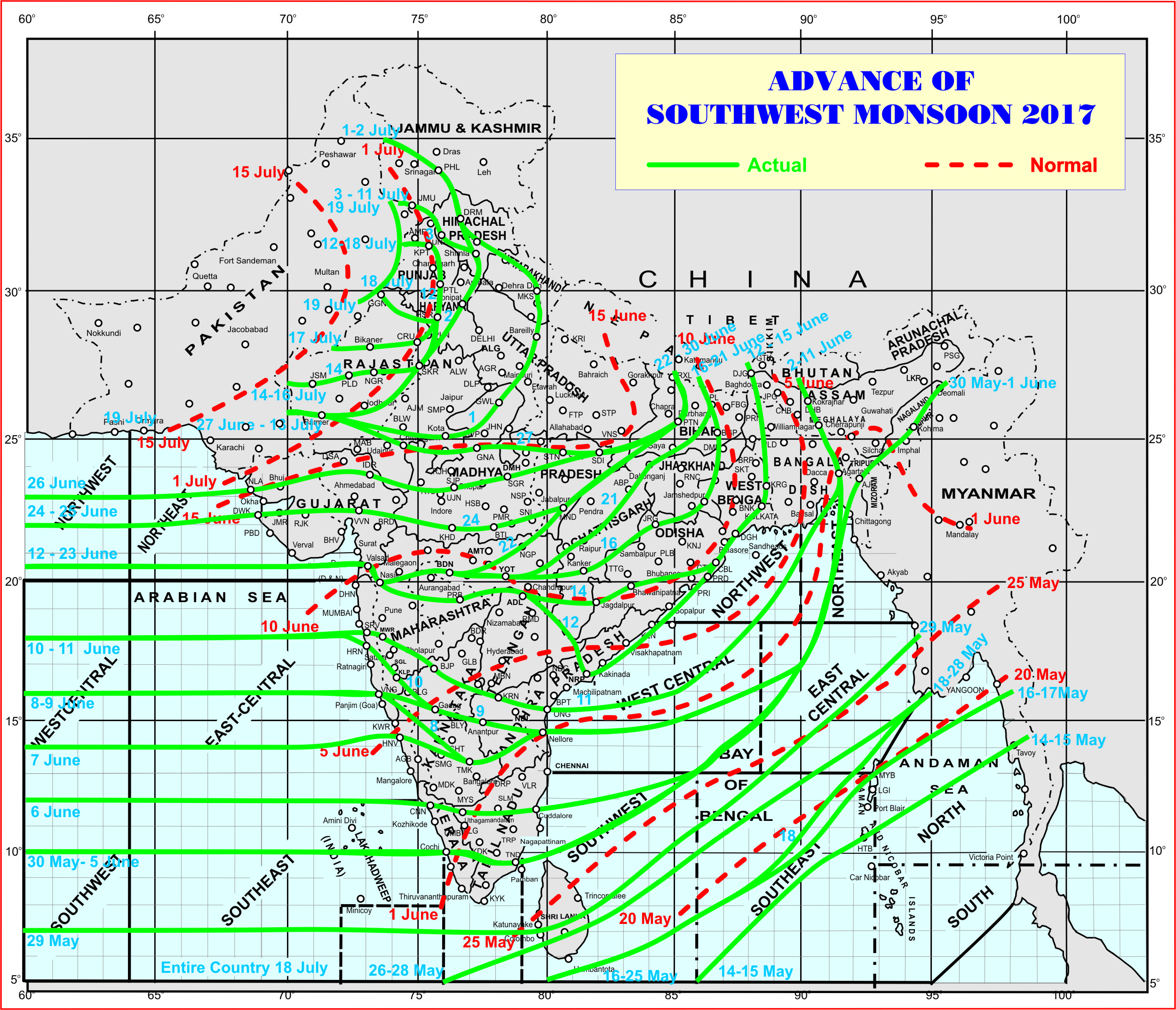
સૌથી ઉપર ની લીલી લીટી ના છેડે જે તારીખ હોઈ તે તારીખે લીટી ની નીચે ના ભાગ માં બધે ચોમાસું પોંચી ગયું છે તેમ સમજવું.
લાલ ત્રુટક લીટી જે તે વિસ્તાર માં નોર્મલ ચોમાસું બેસવાની તારીખ દર્શાવે છે
The date shown at the end of green line shows that the Southwest Monsoon has set in over areas below the green line on that date.
The red dashed line shows the normal date of onset of Southwest Monsoon over various regions.
Weather Forecast: 19th July to 25th July 2017
The UAC at 3.1 km above mean sea level over Northeast Arabian Sea close to Saurashtra/Kutch is expected prevail for some more days. This UAC at times will be as Western end of a broad Upper Air Circulation stretching from Northeast Arabian Sea close to Saurashtra/Kutch to Bay of Bengal System as it BOB System tracks towards Madhya Pradesh across Chattisgarh by 21st July.

Saurashtra, Kutch & Gujarat :
Saurashra, Kutch & Gujarat expected to receive good round of rainfall again with medium, heavy to very heavy rainfall during the forecast period. The rain is expected due to multiple factors. Saurashtra, Gujarat & Kutch will receive 5 centimeter to 10 centimeter of rainfall cumulatively. Many parts of M. P./Gujarat border areas, Rajasthan/Gujarat border areas, North Gujarat, East Central Gujarat, South Gujarat, & some parts of Saurashtra and Kutch could receive higher than 10 centimeters of rain. The rainfall from the Bay of Bengal System would be around 22nd/23rd July. However, there will be rain in different places on different days during the rest of the forecast period. This rainfall forecast relies on current and BOB System track and hence update will be given if there is significant change in the outcome.
Note: Refer/rely on IMD Advisories and Weather Bulletins
આગાહી: તારીખ 19 થી 25 જૂલાઇ
3.1 કિમિ ની ઊંચાઈએ સૌરાષ્ટ્ર/કચ્છ ની નજીક અરબી સમુદ્ર માં એક યુએસી છે જે હજુ થોડા દિવસો રહેશે। .ક્યારેક આ યુએસી એક બહોળા સર્કુલેશન ના પશ્ચિમ છેડા તરીખે જે બંગાળ ની ખાડી વાળી સિસ્ટમ સુધી લંબાશે।. બંગાળ ની સિસ્ટમ 21 તારીખ સુધી માં એમ પી માં પહોંચી જશે
સૌરાષ્ટ્ર , કચ્છ અને ગુજરાત :
સૌરાષ્ટ્ર, કચ્છ અને ગુજરાત માં આગાહી સમય માં અનેક પરિબળો ને હિસાબે ફરી એક વાર વરસાદ નો સારો રાઉન્ડ સમગ્ર ગુજરાત માં આવશે જેમાં મધ્યમ ભારે અને અતિ ભારે વરસાદ અલગ અલગ વિસ્તાર માં અલગ અલગ દિવસે પડશે જેની કૂલ માત્રા 5 સેન્ટિમીટર થી 10 સેન્ટીમીટર અંદાજ છે. એમપી/ગુજરાત બોર્ડર વિસ્તાર, રાજસ્થાન/ગુજરાત બોર્ડર વિસ્તાર, ઉત્તર ગુજરાત, મધ્ય પૂર્વ ગુજરાત, દક્ષિણ ગુજરાત ના ઘણા ભાગો તેમજ સૌરાષ્ટ્ર કચ્છ ના અમૂક ભાગો વધુ વરસાદ રહે જેની માત્રા 10 સેન્ટિમીટર થી વધુ નું અનુમાન છે. બંગાળ ની ખાડી વાળી સિસ્ટમ અનુસંધાન નો વરસાદ મુખ્યત્વે અંદાજે 22/23 જૂલાઇ ના હશે. બાકી ના દિવસો માં પણ અલગ અલગ વિસ્તારો માં વરસાદ પડશે. સૌરાષ્ટ્ર નો કોઈ વિસ્તાર બાકી નહી રહે એવું હાલ અનુમાન છે. આ આગાહી બંગાળ ની ખાડી ના ટ્રેક પર નિર્ભર હોય જો માત્રા માં વધુ પડતો ફરક હશે તો અપડેટ થશે.
નોંધ: હવામાન ખાતા ની આગાહી/સૂચના પર નિર્ભર રહેવું.
Please follow these guidelines or else comment facility will be disabled for some time.
Guideline for Comments:
1. Please post comment if you have a valid email address.
2. Read earlier comments and their reply before posting any comment.
3. Do not ask question about when the update will take place. Usually as and when deemed fit update will be given.
4. I do not forecast for long term, so do not ask for any forecast beyond 7 days.
5. When will we have ‘Good rain for Sowing seed ? Monsoon onset date has nothing to do with Sowing seeds. The latter is individual farmer’s discretion.
6. Do not ask when it will rain in any city, town or village or city. Normally the forecast is given for broad areas of Saurashtra, Kutch & Gujarat. However, for your information Multicity Wunderground Forecast link has been provided for various centers of Gujarat, Sayrashtra & Kutch.
7. All Comments will not be answered. Comments that is meant for larger audience is preferable and will be answered.
8. Please do not repeat your comment if the comment is in moderation (answer pending ).
9. When ever there is an update or I reply to any comment please do not comment ‘thank you’
કમેન્ટ માટે માર્ગદર્શન:
કમેન્ટ અંગે ના માર્ગદર્શન નો અમલ કરો.
1. ખરું ઈ મેઈલ એડ્રેસ હોઈ તો કમેન્ટ કરો.
2. આગળ સવાલો અને તેના જવાબ વાંચી ને તમારી કમેન્ટ કરો.
3. “અપડેટ ક્યારે થશે ?” તેવા સવાલ કરવા નહિ. સામાન્ય રીતે યોગ્ય લાગશે ત્યારે અપડેટ થશે.
4. હું લાંબા ગાળા ની આગાહી નથી કરતો માટે 7 દિવસ થી આગળ માટે આગાહી બાબત કમેન્ટ ના કરવી.
5. વાવણી લાયક વરસાદ ક્યારે થશે અને ચોમાસુ બેસવું બંને અલગ હોઈ શકે. વાવણી તે ખેડૂત નો નિર્યાય છે.
6. “મારા શહેર, કે ગામ માં વરસાદ ક્યારે થશે ?” તેવા સવાલ પૂછવા નહિ. સામાન્ય રીતે સૌરાષ્ટ્ર, ગુજરાત અને કચ્છ ના બહોળા વિસ્તારો ની આગાહી આપેલ હોઈ છે. તમારા વિસ્તાર ના મોટા સેન્ટર માટે વંડરગ્રાઉન્ડ ની આગાહી ની લિન્ક આપેલ છે અહીં મેનુ માં.
7. જે કમેન્ટ વધુ લોકો ને સ્પર્શતો હોઈ તે આવકાર્ય છે અને તેના યોગ્ય જવાબ મળશે. બધા કમેન્ટ નો જવાબ નહીં મળે.
8. કમેન્ટ મોડરેશન (જવાબ પેન્ડિંગ ) હોઈ બીજી વાર પૂછવું નહીં.
9. અપડેટ આવે એટલે કે જવાબ આપું ત્યારે થૅન્ક યુ ની કોમેન્ટ ના કરવી.
It’s too much now…sir how many days more we all have to suffer from this natural calamities….I feel very pain for those people who lost everything…we can’t do anything….
Yes it is beyond imagination.
Tamari weather ni wapsite khub sari 6