Current Weather Conditions on 16th April 2017 @ 12.30 pm. IST
મારુથા વાવાઝોડું મધ્ય પૂર્વ બંગાળ ની ખા માં છે – આજે રાત્રી ના મ્યાનમાર માં પહોંચશે – 16 એપ્રિલ 2017
INDIA METEOROLOGICAL DEPARTMENT
Bulletin No.: 9 (BOB 01/2017)
Sub: Cyclonic Storm (Maarutha) over East Central Bay of Bengal
Time of issue: 1100 hours IST
Dated: 16.04.2017
Sub: Cyclonic Storm (Maarutha) over eastcentral Bay of Bengal
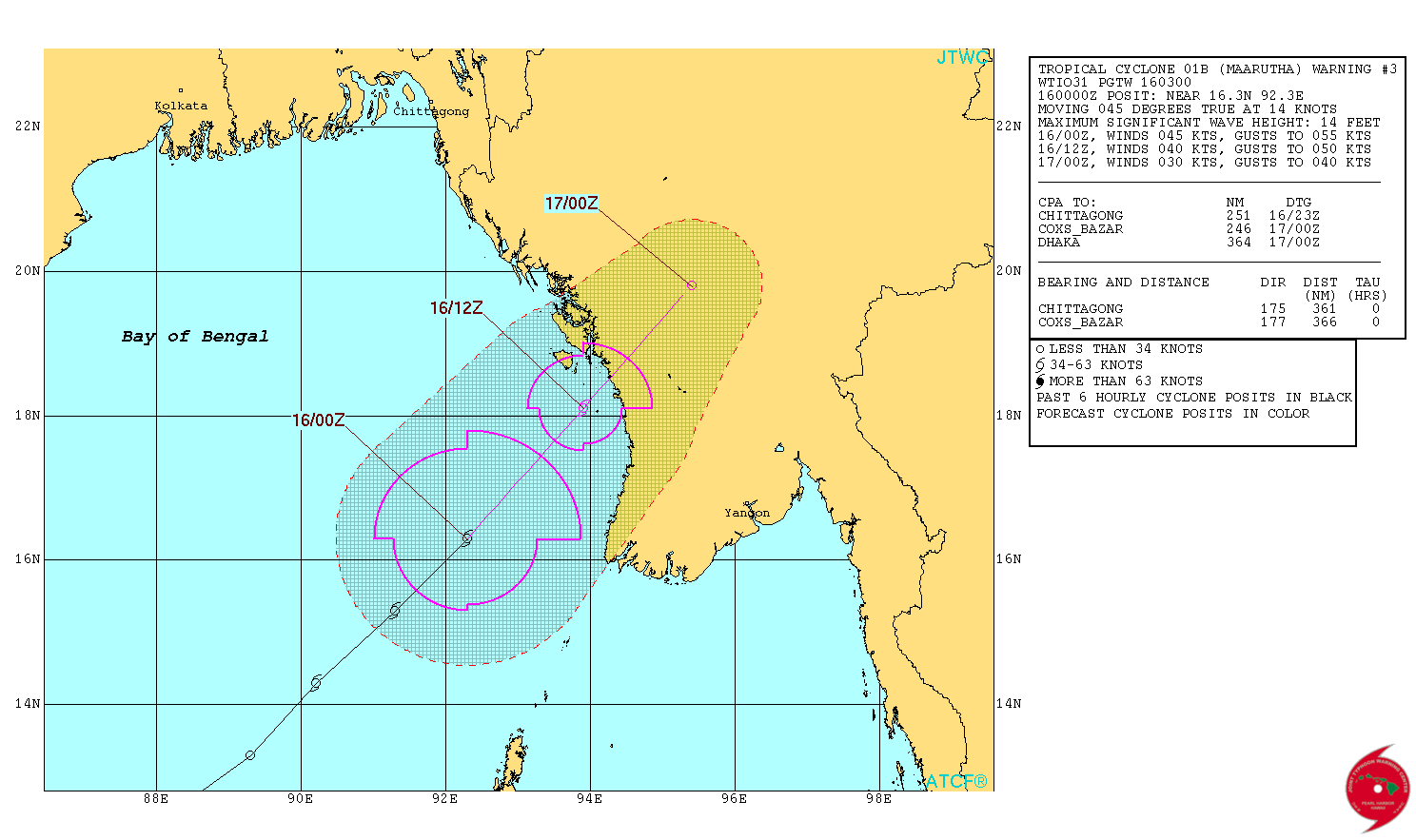
The cyclonic storm (Maarutha) over eastcentral Bay of Bengal further moved northeastwards with a speed of 32 kmph during past 06 hours and lay centred at 0830 hrs IST of today, the 16 th April, 2017 over eastcentral Bay of Bengal near Latitude 16.7º N and Longitude 92.5ºE, about 420 km nearly north of Maya Bandar (Andaman & Nicobar Islands) and 280 km southwest of Sandoway (Myanmar). The system is likely to move northeastwards and cross Myanmar coast near Sandoway around mid-night of today, the 16 th April 2017.
The details available here IMD Bulletin No.: 9 (Nine)
INDIA METEOROLOGICAL DEPARTMENT
Bulletin No.: 8 (BOB 01/2017)
Sub: Cyclonic Storm (Maarutha) over East Central Bay of Bengal
Time of issue: 0830 hours IST
Dated: 16.04.2017
The details of earlier Bulletin is available here IMD Bulletin No.: 8 (Eight)
1 knot= 1.85 km./hour
JTWC Tropical Cyclone 01B MAARUTHA ( Cyclonic Storm “MAARUTHA”) Warning No. 3
Issued at 0300 UTC on 16th April 2017
NRL IR Satellite Image of 01B.MAARUTHA (Cyclonic Storm “MAARUTHA”)
on 16th April 2017 @ 0600 UTC (11.30 am. IST)

| UW-CIMSS Automated Satellite-Based Advanced Dvorak Technique (ADT) Version 8.2.1 Tropical Cyclone Intensity Estimation Algorithm |
|
| Current Intensity Analysis | |
                     UW - CIMSS
              ADVANCED DVORAK TECHNIQUE
                  ADT-Version 8.2.1
         Tropical Cyclone Intensity Algorithm

             ----- Current Analysis -----
     Date :  16 APR 2017    Time :   050000 UTC
      Lat :   17:06:35 N     Lon :   92:58:04 E


                CI# /Pressure/ Vmax
                3.3 / 991.3mb/ 51.0kt


             Final T#  Adj T#  Raw T#
                3.3     3.5     3.5

 Center Temp : -58.0C    Cloud Region Temp : -59.2C

 Scene Type : IRREGULAR CDO*

 Positioning Method : FORECAST INTERPOLATION

 Ocean Basin : INDIAN
 Dvorak CI > MSLP Conversion Used : CKZ Method

 Tno/CI Rules : Constraint Limits : NO LIMIT
                   Weakening Flag : OFF
           Rapid Dissipation Flag : OFF

 C/K/Z MSLP Estimate Inputs :
  - Average 34 knot radii :   70km
  - Environmental MSLP    : 1006mb

 Satellite Name :   HIM-8
 Satellite Viewing Angle : 57.6 degrees

****************************************************
|
Estimate:
Distance of the Cyclonic Storm is around 250 kms. at 0500 UTC (10.30 am. IST) as per UW-CIMSS for landfall over Myanmar.
Caution: Please refer/rely on IMD/RSMC Bulletins/Advisories for Storms & Weather related matter.
સાવચેતી:
સ્ટોર્મ કે હવામાન અંગે ની માહિતી માટે ભારતીય હવામાન ખાતા/ગવર્મેન્ટ ના બુલેટીન/સુચના પર નિર્ભર રહેવું.
Sir dhumas atle hawey par vahan chalavama kai dekhai nahi laight chalu rakhi me gadi chalavi padi 8.30 a.m sudhi hati Rajpar thi Morbi haivey 20 k.m sudho
Sir Rajpar (Amran) mara game aje dhumas Avel6
Haji chalu6
Dhumas etle dhuvada ? ke Zakar ke bhej.
Samanya savare bhej vadhel chhe. Saurashtra ma Megharvo ke evu kai kahe. Ratre thi bhinu bhinu lage khula ma suta hoi toe.
Sir, I have a question.. tame anek comment ma aevu kahyu chhe ke “hu lamba gaada ni aagahi karto nathi”.Ashokbhai,tamari paase weather station chhe,knowledgeable chho,wel experienced chho..toe sir lamba gada ni agahi na karvama aapnu kyu reason hoy shake?hawaman na paribado satat badlata raheta hoy etle ke comment vadhi jay etle?
June ma tamari Long term update aave aevi apexa.
sir aa vrshe arab sagar garm rahese ke thando?
Haal IOD samanya positive chhe. ( Etle ke Arabian Sea garam hoi BOB thi)
Sir imd nu forecast jova maate ni link aapo ne…and mara answer kyaare malse any date .
http://www.imd.gov.in/Welcome%20To%20IMD/Welcome.php aa page ma Right side ni column ma NEW lakhel hoi tema scroll thatu hashe.
Sir amdavad ma garmi kyare ochi thase
Aaje ochhi chhe. Normal thi oonchu pan Heat Wave Nathi.
sir aa vakhte Arabian sea chomasa ma koi system lagu padse ke nahi kutch mate 3 varsh thi te negative chhe to su aa varse pan te negative rahese ke positive chomasa ma koi varsad ni system banse ke nai kutch ke gujrat mate aa vakhte Arabian sea faydo kravse ke nai e janavo sir
Chomasa ni sharoovat ma ane chhelle Arabian Sea ni System banti hoy chhe.
Sir , system banva mate 850 & 700 hpa wind direction par adhar rakhe.
Am I right , sir ?
Yes start UAC thi thay 850 ane 700 hPa
Sir kaale barfore 3 vaage imd monsoon prediction aapse ??
Yes
Sir can you please provide names of most active sea/oceans which give birth to more systems in a year. Bob may be somewhere there I think as I am not much aware but pacific and Atlantic must be there.
Pacific & Atlantic .
See https://en.wikipedia.org/wiki/2016_Pacific_typhoon_season
Test
Yes it worked !!
Today there are some clouds on Bhuj also satellite shows the same coming from Pakistan or from Rajasthan side. Anything special?
Nothing special about it. Morning humidity aaj thi vadhel chhe.
Thank you for answers sir
Sir. Is this appropriate time to prepare local clouds? Is it enough temperature or still some factors are missing? As there were around 45 In Gandhidham since 1 week.
Evu fix kai na hoi clouding nu.