Next Cold Spell 23rd-26th January 2022 Over Saurashtra, Gujarat & Kutch – Temperature To Decrease 5C To 6C From Current Levels
સૌરાષ્ટ્ર, ગુજરાત અને કચ્છ માં ફરી ઠંડી નો રાઉન્ડ 23 થી 26 જાન્યુઆરી 2022 – તાપમાન અત્યાર ના લેવલ થી ફરી 5 થી 6 C ઘટશે
Current Weather Conditions on 19th January 2022
Gujarat Observations:
The Minimum & Maximum Temperature have increased to near normal or above normal during the last two three days and the Minimum as well as Maximum Temperatures are about 1 to 3 C above normal.
Minimum Temperature on 19th January 2022 was as under:
Keshod 12.8 C
Gandhinagar 11.0 C
Rajkot 13.3 C which is 1 C above normal
Kandla 13.5 C
Ahmedabad 14.1 C which is 2 C above normal
Vadodara 12.6 which is normal
Deesa 12.2 C which is 3 C above normal
Bhuj 14.5 which is 5 C above normal
Maximum Temperature on 18th January 2022 was as under:
Ahmedabad 29.0 C which is 1 C above normal
Rajkot 30.9 C which is 3 C above normal
Vadodara 28.8 C which is 1 C below normal
Deesa 27.8 C which is 1 C above normal
Bhuj 30.2 which is 3 C above normal
Forecast: Saurashtra, Gujarat & Kutch: 19th To 26th January 2022
Mostly winds from North & Northeast till evening and subsequently Westerly winds till 23rd January. From 23rd night again winds from North and Northeast for the rest of the forecast period. A western Disturbance will affect North India and adjoining Rajasthan and North Madhya Pradesh. Due to WD there is a slight possibility of scattered showers on 21st/22nd. Very high probability of high wind speeds on 21/22nd January reaching 30 to 40 Km/hour on 22nd January.
Due to Westerly winds there is a good possibility of Foggy conditions on 20th to 22nd January over Saurashtra, Gujarat & Kutch.
Marginal increase in Maximum Temperature till 21st January and subsequently Maximum Temperature will decrease from 22nd January. Subsequently the Max. Temperature will be below normal. Marginal increase in Minimum Temperature till 22nd January and subsequently Minimum Temperature will decrease from 23rd and remain below normal till 26th January. Over all both the Max. and Min. Temperature will be lower by 5 to 6 C from current levels during 23rd to 26th January. Cold Spell Temperature range could again reach single digit over some centers.
પરિસ્થિતિ:
હાલ મહત્તમ અને ન્યુનત્તમ તાપમાન નોર્મલ નજીક અથવા નોર્મલ થી 1 થી 3 C ઉંચા રહે છે.
આગાહી સૌરાષ્ટ્ર, ગુજરાત અને કચ્છ 19 થી 26 જાન્યુઆરી 2022
હાલ નોર્થ અને નોર્થ ઇસ્ટ ના પવન છે તે આજે સાંજ થી પશ્ચિમી તરફ ના થશે . પશ્ચિમી પવન પહેલા કચ્છ અને પછી સૌરાષ્ટ્ર ગુજરાત માં જે 23 સુધી રહેશે. એક વેસ્ટર્ન ડિસ્ટર્બન્સ તારીખ 20/22 માં અસર કરશે નોર્થ ઇન્ડિયા અને લાગુ રાજસ્થાન અને નોર્થ એમ પી ને. આ WD ને હિસાબે સૌરાષ્ટ્ર ગુજરાત અને કચ્છ માં છુટા છવાયા ઝાપટા ની સામાન્ય શક્યતા છે અને સાથે પવન ની ઝડપ પણ વધશે 21/22 તારીખ માં, જે 30 થી 40 કિમિ સુધી 22 તારીખ માં થઇ શકે છે.
WD ને હિસાબે તારીખ 20 થી 22 માં ઝાકળ ની પણ શક્યતા છે સૌરાષ્ટ્ર, ગુજરાત અને કચ્છ માં.
મહત્તમ તાપમાન માં આંશિક વધારો 21 તારીખ સુધી અને ત્યાર બાદ તારીખ 22 થી મહત્તમ તાપમાન ઘટશે. મહત્તમ તાપમાન નોર્મલ થી નીચું આવી જશે તારીખ 23 થી 26 દરમિયાન.
ન્યુનત્તમ તાપમાન માં આંશિક વધારો 22 તારીખ સુધી અને ત્યાર બાદ તારીખ 23 થી ન્યુનત્તમ તાપમાન ઘટશે અને નોર્મલ થી નીચું આવી જશે તારીખ 23 થી 26 દરમિયાન.
મહત્તમ અને ન્યુનત્તમ તાપમાન તારીખ 23 થી 26 દરમિયાન આગળ દિવસો ના તાપમાન કરતા 5 થી 6 C નીચા આવી જશે. આ ઠંડી ના રાઉન્ડ માં ફરી એક ન્યુનત્તમ તાપમાન અમુક સેન્ટરો માં એક આંકડા માં આવી શકે.
Caution: Please refer/rely on IMD/RSMC Bulletins/Advisories for Storms & Weather related matter.
સાવચેતી: સ્ટોર્મ કે હવામાન અંગે ની માહિતી માટે ભારતીય હવામાન ખાતા/ગવર્મેન્ટ ના બુલેટીન/સુચના પર નિર્ભર રહેવું.
Read Comment Policy – કમેન્ટ માટે માર્ગદર્શન વાંચો
How To Upload Profile Picture For WordPress – વર્ડપ્રેસ માં પ્રોફાઈલ પિક્ચર કેમ રાખવું
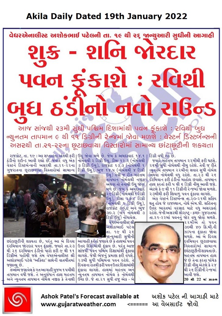
Forecast In Akila Daily Dated 19th January 2022
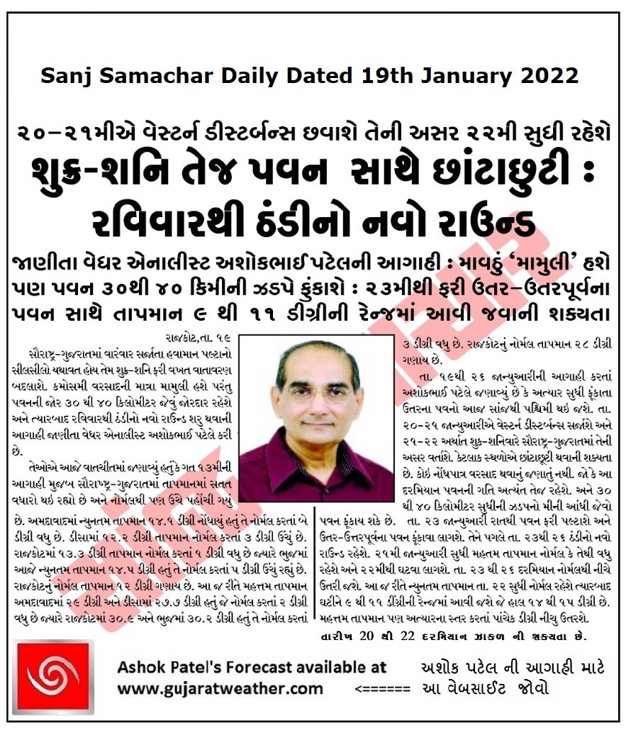
Forecast In Sanj Samachar Daily Dated 19th January 2022