Southwest Monsoon has advanced over entire Andaman Sea and Andaman & Nicobar Islands; into some more parts of Southern Bay of Bengal and some parts of Eastcentral Bay of Bengal today, the 22nd May, 2021
A Low Pressure Has Formed Over East Central Bay Of Bengal
Current Weather Conditions on 22nd May 2021
As Per IMD:
Southwest Monsoon has further advanced into some more parts of Southwest Bay of Bengal; most parts of Southeast Bay of Bengal; some parts of Eastcentral Bay of Bengal and entire Andaman Sea and Andaman & Nicobar Islands today, the 22nd May, 2021. The northern limit of Southwest Monsoon now passes through 5°N/80°E, 10°N/85°E, 13°N/90°E and 16°N/94.5°E.
Under the influence of the Cyclonic Circulation over Southeast & adjoining Central Bay of Bengal, a Low Pressure Area has formed over Eastcentral Bay of Bengal with associated cyclonic circulation extending up to mid tropospheric levels. It is very likely to concentrate into a Depression over Eastcentral Bay of Bengal by tomorrow, the 23rd May morning. It is very likely to move north-northwestwards, intensify into a Cyclonic Storm by 24th May and further into a Very Severe Cyclonic Storm during subsequent 24 hours. It would continue to move north-northwestwards, intensify further and reach north Bay of Bengal near West Bengal and adjoining north Odisha & Bangladesh coasts around 26th May morning. It is very likely to cross West Bengal and adjoining north Odisha & Bangladesh coasts around evening of 26th May, 2021.
IMD મુજબ:
ચોમાસુ પવનો વ્યવસ્થિત થવાથી તેમજ વાદળો અને વરસાદ વધવાથી તેમજ તેની સાથે 3.1 થી 5.8 કિમિ ના લેવલ નું યુએસી આંદામાન દરિયા અને મધ્ય પૂર્વ બંગાળ ની ખાડી પર હતું તે લો પ્રેસર માં પરિવર્તિત થયું છે તેથી આજે 22 મે ના રોજ દક્ષિણ પશ્ચિમ ચોમાસાએ આંદામાન ના દરિયા માં , દક્ષિણ બંગાળ ની ખાડી ના અમુક ભાગ તેમજ આંદામાન નિકોબાર ના સમગ્ર ટાપુઓ માં તેમજ મધ્ય પૂર્વ બંગાળ ની ખાડી માં પ્રવેશ કર્યો છે. 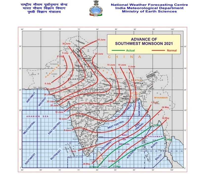 IMD SPECIAL MESSAGE TIME OF ISSUE: 1300 HOURS IST DATED: 22.05.2021
Weather Conditions on 22nd May 2021
Observations:
The Maximum Temperature has been below normal last few days. Now the normal Maximum Temperature for most centers is around 40C/41 C. Maximum Temperature on 21st May 2021 was as under:
Ahmedabad 36C
Rajkot 39.5C
Amreli 38.0C
Bhuj 37.0C
Surendranagar 40.0C
Forecast: Saurashtra, Gujarat & Kutch: 22nd May to 29th May 2021
The wind direction will vary but mainly it will be Westerly, Southwesterly and North Westerly direction during the Forecast Period. High wind speeds up to 15-30 km per hour possible evening time from 22nd-24th. Subsequently for rest of forecast period, the winds will be higher and at times may be up to 25-40 km/hour. Scattered Clouds expected from 25th May onwards.
The Maximum Temperature is below normal and will become normal during the forecast period. Maximum Temperature will be near normal (39/40C-41/42C).
Caution: Please refer/rely on IMD/RSMC Bulletins/Advisories for Storms & Weather related matter.
સાવચેતી: સ્ટોર્મ કે હવામાન અંગે ની માહિતી માટે ભારતીય હવામાન ખાતા/ગવર્મેન્ટ ના બુલેટીન/સુચના પર નિર્ભર રહેવું.
Click the links below. Page will open in new window
Read Forecast In Akila Daily Dated 22nd May 2021
Read Forecast In Sanj Samachar Daily Dated 22nd May 2021
Read Comment Policy– કમેન્ટ માટે માર્ગદર્શન
ઉપર ની બધી અલગ લિન્ક ક્લિક કરો. નવી વિન્ડો માં પેજ ખૂલશે